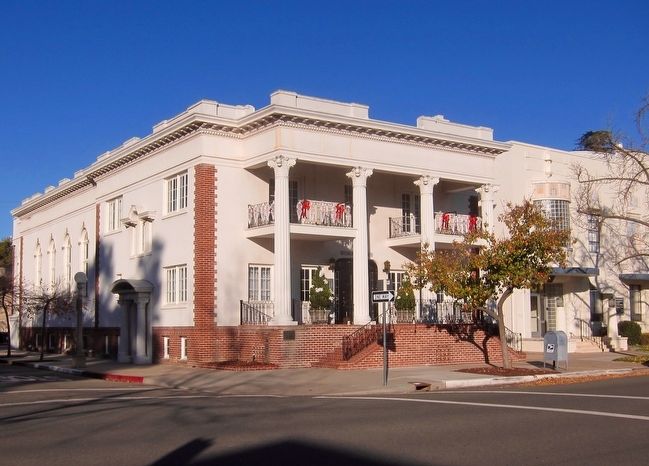
On West Pine Street at North Lee Avenue, on the right when traveling west on West Pine Street.
On May 20, 1988 this unique 1923 Roman style building was placed on the National Register of Historic Places.
In celebration we honor those women of vision who in 1906 started this club, first known as the Lodi Improvement Club. Their efforts . . . — — Map (db m91787) HM
This Property Has Been
Placed On The
NATIONAL REGISTER
OF HISTORIC PLACES
By The United States
Department Of The Interior
National Register of Historic Places Statement of Significance:
Building/structure dates: 1890 initial . . . — — Map (db m12539) HM
On Main Street south of Broadway Street, on the left when traveling south.
The finest playhouse between San Francisco and San Jose opened here January 20, 1896. In 1921, the building was purchased by Redwood City Masonic Lodge which was instituted August 28, 1863. — — Map (db m62625) HM
Near Woodside Road (California Route 84) north of Hess Road, on the right when traveling south.
The GRAND ARMY of the REPUBLIC was a fraternal organization composed of honorably discharged veterans of the Union Army, Navy, Marine Corps and Revenue Cutter Service who served in the American Civil War. Founded in 1866, it grew to include about . . . — — Map (db m202545) HM
On Clinton Street north of Broadway, on the right when traveling north.
The Redwood City Woman's Club was the first independent
women's organization in Redwood City. The women of Redwood
City and the vicinity formed the club to provide social, service,
and educational opportunities for its members. One of . . . — — Map (db m186431) HM
Near South Broadway (State Highway 135) south of West Main Street, on the right when traveling south.
On this site September 28, 1905 representatives of the Masonic Grand Lodge of California convened to place the cornerstone of the first Masonic temple in Santa Barbara County.
Among those famous representatives present were Edward H. Hart, acting . . . — — Map (db m162353) HM
On South McClelland Street south of East Cook Street, on the right when traveling south.
The original Masonic cornerstone was
dedicated October 1908 by Dr. W.T. Lucas,
past Grand Master of Masons in California
and the officers of Santa Maria's
Hesperian Lodge #264, E.&A.M.
A $10,000 grant from Andrew Carnegie financed
Santa . . . — — Map (db m161711) HM
On East Campbell Avenue at South 1st Street, on the left when traveling west on East Campbell Avenue.
The Campbell Country Woman's Club raised the funds to build this Spanish Colonial Revival-style structure in 1923. The town library and public meeting rooms were housed here until the 1960's .
The Woman's Club founded the Campbell Historical . . . — — Map (db m101521) HM
On Monterey Road, on the right when traveling north.
The town of Coyote was established on a popular route known as El Camino Real by the Mexicans who traveled it. This route linked the missions throughout California. Originally named Burnett, Coyote developed around a post office that was housed in a . . . — — Map (db m207448) HM
On South 11th Street, on the right when traveling south.
In December 1894, nine women met to form the San Jose Woman's Club . Supporting temperance and suffrage, the members also promoted education, community improvements and the arts. The club was opened to women of all creeds and nationalities. Today, . . . — — Map (db m108410) HM
On North 3rd Street north of Saint John Street, on the right when traveling north.
Local Scottish Rite Masons built their hall on this site in 1909. Designed by George Page, it was a simple rectangular structure with a severe Greek Revival façade. When the Masons moved into the new Scottish Rite Temple in 1925, the vacated . . . — — Map (db m30261) HM
On North 3rd Street south of Saint James Street, on the right when traveling north.
Built as the Scottish Rite Temple in 1925-25, this distinguished structure was designed by architect Carl Werner. The entry portico, with its six Ionic columns and unusual Egyptian ornamentation, lends the buildings special grandeur. In 1981, the . . . — — Map (db m30285) HM
Near Phelan Avenue east of Senter Road, on the left when traveling east.
Hanford Lennox Gordon was born in 1846 and over his lifetime held a variety of positions as attorney, and officer for the Union Army during the Civil War, a farmer, and a rancher.
Hanford and his wife, Mary, moved to San José from Minnesota in . . . — — Map (db m227093) HM
Near Phelan Avenue near Senter Road. Reported permanently removed.
Welcome to the
Gordon House
Home of the Rotary Club of San Jose
Hanford Lennox Gordon was born in 1846 and over his lifetime held a variety of positions as attorney, and officer for the Union Army during the Civil War, a farmer, and . . . — — Map (db m52126) HM
On Lafayette Street just south of Lewis Street, on the left when traveling south.
The Portuguese men and women of Santa Clara founded this building, commonly known as the S.E.S. Hall, in 1896. This fraternal organization was created as a means of communication and socialization. It gave the Portuguese community a place to meet, . . . — — Map (db m54026) HM
On De La Cruz Boulevard at Martin Avenue, on the right when traveling east on De La Cruz Boulevard. Reported permanently removed.
Second site 1799–1784 Mission Santa Clara de Asis.
Original site January 12, 1777 founded by the Franciscan Fathers 967 yards north, 334 yards south of Bayshore Highway Bridge No. 37–64. — — Map (db m195668) HM
Near Lasuen Mall south of Panama Mall, on the right when traveling south.
Built with funds raised by Stanford women
Formally opened February 18, 1915.
Presented to the University September 1, 1966, by the Board of Directors of the Stanford Women’s Club. — — Map (db m232008) HM
On Ocean Street, on the left when traveling north.
Founded in 1862, and continuously operated , by the Santa Cruz Lodge #96, Independent Order of Odd Fellows. The park has grown from a modest size lot to over 30 acres of well maintained grounds. The park has had endowment care since the turn of the . . . — — Map (db m203153) HM
On Pacific Avenue at Front Street, on the right when traveling south on Pacific Avenue.
The old Phoenix Building (1549 Pacific Ave.) was constructed about 1866, and became the old Phoenix Saloon and lodgings. Around 1900 it headquartered the Santa Cruz Stage & Express Co. until 1910, then Hugo Photo Studio (1924-27), a fruit market . . . — — Map (db m212314) HM
On Water Street at North Pacific Avenue, on the right when traveling west on Water Street.
Marker One:
Dedicated July 4, 1976 in celebration of the Bicentennial of the founding of our country. Originally erected by the Independent Order of Odd Fellows in 1900, the Town Clock was created and later restored in a legacy of freedom, . . . — — Map (db m212371) HM
On East Center Street at Howard Street, on the right when traveling north on East Center Street.
The Masonic Lodge was constructed of locally made brick on this site prior to 1866. Mount Shasta Lodge No. 281 F. & A.M. occupied the building from 1886 to 1895, then again from 1934 until they sold the building to the City of Anderson in 2001. . . . — — Map (db m70344) HM
On Main Street, on the right when traveling south.
The French Gulch Lodge No. 75, Independent Order of Odd Fellows was established on May 5, 1858. Erastrus Dickinson was first Noble Grand on June 24, 1864. All records of the lodge as well as the original charter were destroyed by fire. The new lodge . . . — — Map (db m70328) HM
On Niagara Street near Main Street, on the right when traveling south.
Officers of the International Order of Odd Fellows Lodge, chartered 1858, commissioned the construction of a private and public cemetery in August, 1866. The public section opened May 16, 1868, with the lodge members interred thereafter as their . . . — — Map (db m89137) HM
Historical dates conflict on the exact date of construction, but most agree it was built between 1883 and 1885. Records indicate the Clinton Lodge of the Free and Accepted Masons #119 held their first meeting in the in the new building in June of . . . — — Map (db m133560) HM
On Highway 299 near Mackley Alley, on the right when traveling west.
Oldest Chartered Masonic Lodge in California
Free and Accepted Masons
Originally chartered by the most worshipful Grand Lodge of Missouri, A F and A M
May 10th AL5848 (1848)
Dedicated in due and ancient form this 10th day of May AL5998 . . . — — Map (db m1137) HM
On Eureka Way (California Route 299), on the right when traveling west.
The oldest Masonic Lodge in the State of California. Chartered by the most worshipful Grand lodge of Missouri on the 10th of May, 1848.
This building was dedicated on Saint John’s day, the 27th of December, 1854 and has been in continuous use by . . . — — Map (db m70429) HM
On Commercial Street (California Route 49) at Pearl Street, on the left when traveling east on Commercial Street.
The Mountain Shade Lodge No. 18 F. & A.M. received it’s charter on May 5, 1852. Prior to that date they operated under a dispensation. The Masons met originally in the Craycroft Building. Then erected their own building on this site in 1852. The . . . — — Map (db m44242) HM
The Etna Chapter of the Independent
Order of Odd Fellow #184 was founded
on January 18, 1871. There were 11
charter members. This brick building
was designed by Louis Fafa and was
built in 1881. The upper floor was used
for lodge . . . — — Map (db m112494) HM
On Front Street near Henly-Hornbook Road, on the right when traveling north.
This plaque commemorates the 60th anniversary of the American Legion. The national charter was signed in Hornbook on Sept. 16, 1919 by President Woodrow Wilson while his train stopped enroute from Portland to San Francisco. — — Map (db m88022) HM
On 4th Street south of West Miner Street, on the left when traveling south.
On or near this site between 1854 and 1856 the members of the Ancient and Honorable Order of E Clampus Vitus had a meeting hall. During the day it was used as a court room and clerks office. — — Map (db m70186) HM
On West Miner Street, on the left when traveling west.
The Arcade Saloon once stood on this site in 1856 where Lotta Crabtree began her singing and dancing profession, and John C. Heenan, ‘The Benicia Boy’ started his fighting career. The building was completely destroyed by the Great Fire of 1871, but . . . — — Map (db m70131) HM
On West Miner Street near South Broadway Street, on the left when traveling west.
I.O.O.F. Yreka Lodge #19 was instituted in 1853 and has been at this location since that date. Multiple transactions in ownership and lot size and shape occurred before two, one-story brick buildings were erected on this site. These buildings . . . — — Map (db m70129) HM
On West Miner Street at 3rd Street, on the right on West Miner Street.
Originally known as the Wetzel Lot, a brick building stood here in 1880 which housed the fire department – Engine & Hose No. 1. A new building with a massive edifice was erected on the site in 1926 by four Masonic orders who sold shares at $50 . . . — — Map (db m70081) HM
This tablet dedicated to his memory. He was State Senator 1852-1853; Mayor of Santa Barbara, Captain of California Volunteers serving in Arizona during the Civil War 1861-1865. He was a loyal member of the Ancient and Honorable Order of E. Clampus . . . — — Map (db m58330) HM
On West J Street, on the right when traveling east.
The first Masonic hall built in California was begun in the summer of 1850, occupied by the lodge October 14, 1850, and formally dedicated December 27, 1850. This building served as the Masonic Temple for Benicia Lodge No. 5 until 1888, when the . . . — — Map (db m16317) HM
On Main Street near Davis Street, on the left when traveling east.
The Independent Order of Odd Fellows (I.O.O.F.,) Vacaville Lodge No. 83, re-built this structure of brick and cast-iron columns in 1889. The previous two building burned in 1877 and 1884. The earthquake of 1892 seriously damaged the front of the . . . — — Map (db m17636) HM
On Main Street near School Street, on the right when traveling east.
Kentucky native Sidney Clay Walker crossed the plains in 1850 and in 1872 settled in the Vaca Valley where he eventually owned 1,200 acres. He was an organizer of the Vacaville Water and Light Company in the 1890's and in 1896 built this brick . . . — — Map (db m17661) HM
In recognition for his continuous dedication to the preservation of western history through his world – renowned artistic endeavors: for expressing his love of the Order through the sculptured likeness of the men who have labored to preserve . . . — — Map (db m54590) HM
On Georgia Street near Sonoma Boulevard, on the right when traveling east.
The Red Men's Hall is a variant of the Renaissance Revival style and exhibits three Native American terra cotta portraits. The building is the home of Samoset Tribe No. 22, organized in 1869. The building was constructed in 1925 and is the work of . . . — — Map (db m100460) HM
Built by 1846 Missouri emigrants John and Harriet Ray in 1847. After his success in the Rose Bar Gold Fields, the large adobe portion was added in 1849 by Indian labor to the wooden house on the east end. It was leased as headquarters for officers . . . — — Map (db m15253) HM
On 1st Street East, on the left when traveling south.
Sonoma Valley Women’s Club was founded September 21, 1901 by eleven local women led by Martha Stearns.
In 1911 the lot at 574-First Street East was purchased by S.V.W.C. from Katherine Poppe on which their club house was to be built. Funds for . . . — — Map (db m78923) HM
On Sonora Road, 0.2 miles north of Kennedy Road, on the right when traveling north.
The establishment of Estanislao Chapter 58 occurred on June 21, 1958. The inaugural meeting took place at the historic Tulloch Flour Mill in Knights Ferry under the direction of Noble Grand Humbug W.S. 'Walt' Hargrove. There were forty-eight . . . — — Map (db m178005) HM
On Yosemite Boulevard (California Route 132), on the right when traveling east.
This is one of the oldest continuously occupied buildings in LaGrange. In 1857, Lodge #65 of the Independent Order of Odd Fellows of California was formed.
The Odd Fellows purchased the two story jail from the County in 1862 and it was used for . . . — — Map (db m94798) HM
Formerly Independent Order of Odd Fellows (Wildey Lodge) Cemetery
The flagpole and bricks used in this monument are from the Hughson Hotel built in 1913 by Luella Hughson. This modern hotel had a 36 foot redwood flagpole where the American . . . — — Map (db m58587) HM
On Main Street at Fresno Street, on the right when traveling north on Main Street.
The International Order of Odd Fellows building was a wooden structure built in 1892. It was replaced with the current building in 1928. After a 2009 fire, the Odd Fellows Lodge repaired the building. In 2011 the building was purchased by the City . . . — — Map (db m208404) HM
On Main Street at Tulare Street, on the right when traveling south on Main Street.
In 1886 the Lodge was organized in Hills Ferry. They moved to Newman in 1910 to the newly constructed 3 story building. Street level retail space, 2nd floor meeting rooms and 3rd floor the social hall. Knights of Pythias referred to their lodges as . . . — — Map (db m208394) HM
On 2nd Street at B Street, on the right when traveling north on 2nd Street.
The stone which the builders rejected, has become the head of the corner.
This stone appeared on the first Masonic Temple located at the corner of 2nd and Bridge Streets. — — Map (db m63238) HM
On State Highway 99, 1 mile north of South Avenue when traveling south.
This monument was erected on the 75th anniversary of the date of its charter May 10-th 1923 by
Western Star Lodge
No. 2 F.& A.M.
of Shasta, Calif.
The oldest Masonic Chapter in Calif.
Granted May 10-th
1848.
By the Grand . . . — — Map (db m113893) HM
On Main Street (California Route 3 / 229), on the right when traveling north.
In1852 the Cameron Bros. built a 2 story building. Madam La Batcheler purchased it in 1853 and operated the Golden Gate Saloon. Later known as the Polka Saloon, by 1855, the town lodges of ECV, Masons and Son of Temperance met in the upper story . . . — — Map (db m56024) HM
On Main Street (California Route 299), on the right when traveling north.
Built by Richard Clifford in 1855. One of three two story Weaverville structures with outside circular staircases hand made by village blacksmiths. Once home of Mt. Bally Parlor No. 87, Native Sons of the Golden West.
Dedicated by Grand Parlor, . . . — — Map (db m56004) HM
On Main Street (California Route 3/299) just south of Trinity Lake Boulevard (Highway 3), on the right when traveling west.
The first chapter of ECV in Weaverville began in 1855. After a rocky start in the Sierra Nevada Gold County, the organization got a foothold in Mokelumne Hill, in 1851. The first Noble Grand Humbug for the Weaverville Chapter was John C. Burch, a . . . — — Map (db m70304) HM
On Main Street (Route 299), on the right when traveling south.
The spiral staircases of Weaverville have always been a predominant part of this community’s architecture. The structures became a necessity because of the separate ownership of the upper and lower floors.
This stairway, the first of these . . . — — Map (db m56015) HM
On Sierra Drive (California Route 198) at Pogue Avenue, on the right when traveling north on Sierra Drive.
On this site, in 1879, a large two story thirteen room hotel was constructed, known as “The Cottonwoods,” by the partnership of C.W. Crocker and J.B. Wallace of San Francisco, and J.W.C. Pogue. The Pogue family came to this lime kiln area in 1865 . . . — — Map (db m155190) HM
On Parrots Ferry Road (County Road E18), on the left when traveling south.
The inspiration to revive the Ancient and Honorable Order of E Clampus Vitus, a benevolent society prominent in Gold Rush days, occurred fifty years ago to Carl I. Wheat as he traveled from Columbia down to Parrots Ferry on the Stanislaus River. ECV . . . — — Map (db m53303) HM
On Main Street at Lemon Drop Lane, on the right when traveling west on Main Street.
Ignacia Ramirez, female pioneer and native of Mexico, earliest known owner of this Gold Rush building. Upstairs meeting hall of St. James Masonic Lodge #54, acquired 1877 by R.A. Preston. Jamestown Post Office in 1930’s; later medical office of Dr. . . . — — Map (db m33781) HM
On Scott Street at Market Street, on the right when traveling west on Scott Street.
Women's Improvement Club has been placed on the National Register of Historic Places by the United States Department of the Interior. — — Map (db m193824) HM
On Main Street at Davis Street, on the left when traveling west on Main Street.
This is the site of the first meeting
of the Santa Paula Oddfellows lodge,
April 26 1884. The original hall was
destroyed by fire in 1903. The present
building with the clock tower was erected
in 1905. Community donations made it possible
to . . . — — Map (db m175682) HM
On Cleveland Avenue, on the right when traveling west.
Grandson of William Bull Meek; like his illustrious grandfather, Acton Cleveland served Camptonville very well over his lifetime. He operated the Meek Mercantile Store, became a Judge of the District Court, was a Deputy County Assessor, Post Office . . . — — Map (db m39816) HM
This 1854 A.J. Downing designed "Carpenters Gothic" is among the earliest such wood frame structures in the state. Built by Josiah Prentiss Brown, miner, 49er, local banker, multi-term state legislator and Commander of the Yuba Light Infantry, Co. . . . — — Map (db m39811) HM
Near Cleveland Avenue, on the left when traveling east.
Gravel Range Lodge No. 59 was granted dispensation on June 29, 1854. The charter was granted May 4, 1855. There was an original membership of 28 members. The first meetings were held over a store, which was later destroyed by fire. There were three . . . — — Map (db m61604) HM
Here lies a Clamper, and the namesake of Chapter 10, E Clampus Vitus; a long time resident of Camptonville, and pillar of community.
The chapter bearing his name was instituted on the second day of April in the year of our Clampatriarch Adam & of . . . — — Map (db m39810) HM
On Loma Rica Road at Summit Avenue, on the left when traveling north on Loma Rica Road.
The National Grange of the Order of the Patrons of Husbandry is a fraternal organization that encourages families to band together to promote the economic and political well-being of the community and agriculture and was founded in 1867. Loma Rica . . . — — Map (db m93917) HM
On 1st Street at D Street, on the right when traveling east on 1st Street.
Within these walls, on Jan. 22, 1896, Lord Sholto Douglas, theatrical entrepreneur, and son of the Marquis of Queensbury of Pugilistic fame, was initiated into the mysteries of ECV. Though Douglas went on to riches, subsequent publicity of his . . . — — Map (db m40152) HM
On South Rapp Street at West Littleton Boulevard, on the right when traveling south on South Rapp Street.
The Weston Lodge Number 22 of the Ancient Free and Accepted Masons was organized in Littleton in 1872. It was named for Allyn Weston, a Harvard graduate who had published a Masonic magazine in Detroit before moving to Colorado in 1860 to practice . . . — — Map (db m177636) HM
On Sixth Street at Rose Street, on the right when traveling west on Sixth Street.
Georgetown Lodge No. 12 AF & AM is one of the oldest continuously active fraternal orders in Colorado. The builder, Master Mason Charles Fish, incorporated Masonic symbols into the beautiful stained-glass windows. In 1912 this pioneer lodge combined . . . — — Map (db m173424) HM
On Auraria Parkway at 12th Street, on the right when traveling east on Auraria Parkway.
Auraria is the site of the first informal gathering of Freemasons in what is now Colorado in Fall of 1858 and the first regular communication of Freemasons in the Territory of Colo. on October 1, 1859. These Freemasons were gold seekers. The search . . . — — Map (db m203471) HM
The Association of Graduates Memorial Pavilion was
made possible through the generosity of more than 11,000
graduates, friends and parents. The Pavilion honors all
Academy graduates for their unwavering service to the
United States of . . . — — Map (db m162484) HM WM
On Grand Avenue (Colorado Route 82) south of 8th Street, on the right when traveling south.
Sovereign Grand Lodge of Independent Order of Odd Fellows (I.O.O.F) working hard to establish their own permanent meeting place.
After being in many different locations in the downtown, the began construction of their new lodge in 1898. The . . . — — Map (db m120086) HM
On West Main Street at North 5th Street, on the right when traveling west on West Main Street.
The Independent Order of Odd Fellows insignia still appears on the façade of this building, built in 1990. As with many early buildings, the ground floor was used for commercial purposes. Here the ground floor was occupied by a saloon, later by J.W. . . . — — Map (db m120119) HM
On Main Street, on the right when traveling south.
One of the brick “fire proof” buildings which was destroyed in the fire of 1874 was Abraham Jacobs’ old store, located on this site. By August, a new one story building had been completed here and the old store was back in business for . . . — — Map (db m51833) HM
On Virginia Avenue at Teller Street, on the right when traveling east on Virginia Avenue.
On October 30, 1919, a group of thirty returned soldiers met at the Court House to formulate plans for an American Legion post. The Charter of which was granted November 22, 1919. The Post was named Bruce-Frew, honoring two men from Gunnison . . . — — Map (db m158730) HM
On Main Street (State Highway 135) at Virginia Avenue, on the right when traveling north on Main Street.
The Independent Order of Odd Fellows, IOOF, is an international fraternal organization that was founded on the North American continent in 1819. The command of the IOOF is to "visit the sick, relieve the distressed, bury the dead and educate . . . — — Map (db m158806) HM
On Washington Avenue north of 11th Street, on the right when traveling north.
City of Golden
Downtown Landmark
The Stewart Block building was completed in 1892. It served as a grocery for 52 years under a variety of owners including Caleb E. Parfet, Elvyn E. Stewart, and Leonard Vogel. The motto of the original building . . . — — Map (db m50593) HM
On West 13th Street east of Slater Street, on the left when traveling east.
Erected through the cooperation of Federal, State and local governments by Works Progress Administration. Dedicated to the enrichment of human lives. A record of permanent achievement. — — Map (db m118240) HM
On Main Street (Colorado Route 14) east of South 4th Street (U.S. 6), on the right when traveling east.
With the faith and courage of their forefathers who made possible the freedom of these United States The Boy Scouts of America dedicate this copy of the Statue of Liberty as a pledge of everlasting fidelity and loyalty 40th Anniversary . . . — — Map (db m177078) HM
On South 4th Street at Ute Avenue (U.S. 50), on the right when traveling south on South 4th Street.
Lodge #575 was founded in 1900 by local drug clerk, 32-year-old J. Morrison Wohlfort. Before the present Lodge home was built, the founding Benevolent and Protective Order of Elks met in the I.O.O.F Hall at 454 Main Street.
Lodge #575 was . . . — — Map (db m120078) HM
On East Main Street, on the right when traveling north.
Within a few years, one generation passes and another comes on the scene. If those who follow are to have any notion of what it was that went before, it must fall to those who possess a tie to the past to preserve what may be known. In that . . . — — Map (db m120139) HM
On Scenic U.S. 50/287 at State Highway 196, on the right when traveling west on U.S. 50/287Scenic .
The Heart of the Old West Santa Fe Trail Scenic and Historic Byway is an 188 mile portion of the Santa Fe National Historic Trail designated as one of America's Byways and a Colorado Scenic Byway. The entire Santa Fe Trail begins in . . . — — Map (db m213699) HM
On 10th Avenue just north of 9th Street (Business U.S. 34), on the left when traveling north.
William Bowman designed this building for Greeley’s Masonic Lodge in 1927. Greeley’s Occidental Lodge No. 20 A.F. & A.M. was established in November 1870, and the group met in various locations until this temple was built, including in the Greeley . . . — — Map (db m222265) HM
On 9th Avenue at 9th Street, on the right when traveling south on 9th Avenue.
With the faith and courage of their forefathers who made possible the freedom of these United States The Boy Scouts of America dedicate this replica of the Statue of Liberty as a pledge of everlasting fidelity and loyalty 40th Anniversary . . . — — Map (db m177075) HM
On Prospect Street at Bailey Avenue, on the right when traveling west on Prospect Street.
In 1870, A Branch Line from the Branchville train station was built to offer service to the wealthy New Yorkers who began arriving to spend their summers in Ridgefield. Many of these "summer people" had their own private railroad cars. . . . — — Map (db m31591) HM
On Main Street (Connecticut Route 35) at Bailey Avenue, on the right when traveling south on Main Street.
The International Order Of Odd Fellows, Pilgrim Lodge No. 45 was established in Ridgefield in 1847, meeting in the Masonic Hall until 1895 when the structure was destroyed in the Great Fire. The Odd Fellows built their own building in 1928 and . . . — — Map (db m31970) HM
On Main Street north of Seyms Street, on the right when traveling south.
Johnson came to Hartford in 1916. She and her husband co-owned the only Black-owned funeral services company in the state of Connecticut at the time.
She co-founded the Colored Women's League in 1917 and was its president. Her organization . . . — — Map (db m230466) HM