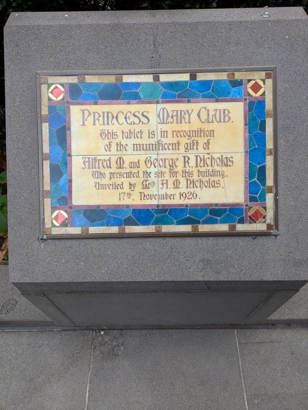
On Lonsdale Street 0.1 kilometers west of Jones Lane, on the left when traveling east.
Pharmacists and philanthropists
The founders of the Aspro company, Alfred and George Nicholas were generous benefactors to a range of causes in Melbourne. In the 1920s a £15,000 donation from the Nicholas brothers helped the Church construct . . . — — Map (db m303277) HM
On Exhibition Street 0.1 kilometers north of La Trobe Street, on the left when traveling south.
As the pre-eminent scientific society of the State of Victoria. The Royal Society of Victoria is modelled on the ideals of the Royal Society (London), and provides a focus for scientists and all members of the Victorian Community interested in . . . — — Map (db m302939) HM
On Exhibition Street 0.1 kilometers south of Victoria Street, on the left when traveling south.
The Royal Society of Victoria
Centenary Monument
1859-1959
This monument was unveiled by the Patron of the Society,
His Excellency, the Governor of Victoria, General Sir Dallas Brooks,
K.C.B. K.C.M.G. K.C.V.O D.S.O K.St.J.
7th . . . — — Map (db m302941) HM
On Casselden Place 0.1 kilometers south of Little Lonsdale Street, on the right when traveling north.
In 1867 William Henry Blakeley set up shop as a saw doctor in Melbourne, manufacturing saws and blades and importing tools. Hailing from a traditional cutler-trade family in Sheffield UK, Blakeley initially travelled to New Zealand in 1865, where he . . . — — Map (db m302203) HM
On Little Lonsdale Street 0.1 kilometers west of Gorman Alley, on the left when traveling west.
Walking around Little Lon today, it is hard to imagine life in the crowded urban neighbourhood of the nineteenth century. Above ground, very little is left that tells us about the many varied people who called this place home. Below ground is a . . . — — Map (db m302416) HM
On Madame Brussels Lane at Lonsdale Street, on the left when traveling north on Madame Brussels Lane.
Madame Brussels Lane
The Women of Little Lon
Mother? Sex worker? Entrepreneur?
Who were the women of Little Lon?
Popular press exaggerated Melbourne's back slums as a places of sin, poverty and fallen women. Brothel owner . . . — — Map (db m302942) HM
On Bowen Street at La Trobe Street, on the left when traveling south on Bowen Street.
Francis Ormond's vision and generosity
resulted in the establishment of
The Working Men's College
now the
Royal Melbourne Institute of Technology.
Classes commenced in this building
7th June 1887.
This commemorates the centenary of . . . — — Map (db m303839) HM
On Casselden Place 0.1 kilometers south of Little Lonsdale Street, on the left when traveling east.
(Source: Tasmanian Archives and Heritage Office, Prisoner's Record Book GD63)
Yokohama (real name Ti Cum Ah Chung), was a prostitute who operated out of 17 Casselden Place during the early nineteenth century. Her mugshot was taken in 1903, . . . — — Map (db m302208) HM
On Victoria Street (Victoria Route 32) 0.1 kilometers west of Cobden Street, on the left when traveling west.
Tombstone Territory
In the late 1950s, claims about corrupt merchants and unfair practices at the wholesale fruit and vegetable market led to a 1960 Royal Commission to examine the existence of cartels. The claims were unproven, yet the ill . . . — — Map (db m309686) HM
On Lonsdale Street 0.1 kilometers west of Jones Lane, on the left when traveling east.
Wesley Church is part of the Uniting Church in Australia. We acknowledge the sovereign First Peoples of this land and pay our respect to their past and present Elders and descendants.
The logo above includes these of the Uniting Church in . . . — — Map (db m303355) HM
On Victoria Street (Victoria Route 32) at Elizabeth Street on Victoria Street.
A Place to Meat
In the Meat Hall the colour of the Market is seen in all its hues. For years, the characters of the Meat Hall - not only the meat sellers, but also fishmongers and rabbitos - have added to the Market's charm. Queen Victoria . . . — — Map (db m308864) HM
On Victoria Street west of Cobden Street, on the left when traveling west.
Victoria Street Shops
The Melbourne General Market Site Act in 1877 enabled the Melbourne City Council to take over land to the north of the original Market. This included most of the land along Victoria Street that would be . . . — — Map (db m309682) HM
On La Trobe Street 0.1 kilometers east of Queen Street, on the left when traveling east.
Victorian Women Doctors of World War One
1914 - 1918
Women doctors of the British Empire were denied the right to officially enlist but these six courageous Melbourne women doctors served as surgeons and medical officers during World War . . . — — Map (db m309741) HM
On Lonsdale Street 0.1 kilometers west of Jones Lane, on the left when traveling east.
Guiding the way
Wesley Church was officially opened on 26 August 1858. Designed by pre-eminent Melbourne architect Joseph Reed, the Gothic Revival style church was completed in less than a year. This was Melbourne's first substantial church . . . — — Map (db m303289) HM
Near Little Lonsdale Street 0.1 kilometers south of Bennetts Lane.
A flaked glass tool was found during the 2017 Wesley Place archaeological excavations. The tool was expertly crafted using flaking techniques perfected by Aboriginal people originally for stone tools. This flaked glass scraper illustrates the . . . — — Map (db m303360) HM
Near Russell Street 0.1 kilometers south of MacKenzie Street.
This archway in the western Gaol wall, was later infilled to create a secure exercise Yard for female prisoners (west of this wall). The archway was subsequently re-opened and window installed to get some natural light into the Police Garage, . . . — — Map (db m303783) HM
On Victoria Street (Victoria Route 32) at Cobden Street, on the left when traveling west on Victoria Street.
A and B sheds were constructed from 1877 and form part of the Upper Market bounded by Queen, Victoria, Peel and Franklin Streets. In 1905 A and B sheds were extended to Peel Street and their verandah and parapet added. By 1920 massive retail trade . . . — — Map (db m309674) HM
On Bowen Stret 0.1 kilometers north of La Trobe Street, on the left when traveling north.
Working Men's College
Erected in 1891 as an extension to the Working Men's College, this Gothic revival building was designed by architects Oakden, Addison and Kemp.
Essentially a workshop, it is very much in the tradition of 19th century . . . — — Map (db m303840) HM
On Flinders Lane at Centre Place, on the right when traveling west on Flinders Lane.
Back in school, Craig was always picked last for sport. But when he dropped his brand new iPhone here on 30 October 2019, Craig instinctively threw out his leg. The phone bounced off his thigh, spun once in the air, and landed softly on top of his . . . — — Map (db m299346) HM
On Spring Street at Spring Street, on the left when traveling north on Spring Street.
A significant early example of modern multi-storey apartment buildings, Alcaston House was designed by architects A & K Henderson in 1928 to provide residential apartments and office suites. The use of Classical detailing and Renaissance Revival . . . — — Map (db m299433) HM
On Bourke Street at Spring Street, on the left when traveling west on Bourke Street.
The steps of Parliament House (1856) provide us with a good view of the emerging theatre, bohemian and cafe society end of Bourke Street in 1900. The Windsor Hotel annexe has changed little from the Old White Hart Hotel pictured here. The old . . . — — Map (db m299547) HM
On Collins Street 0.1 kilometers west of Russell Street, on the right when traveling west.
Melba was born in Burnley Street Richmond on 19 May 1861. Christened Helen Porter Mitchell, she worshipped in The Scots' Church, sang in its choir and attended Presbyterian Ladies College before making her debut at the Monnaie Theatre in Brussels in . . . — — Map (db m305883) HM
On Flinders Street at Russell Street, on the left when traveling east on Flinders Street.
Duke of Wellington Hotel
is registered by the Heritage Council of Victoria
This rare example of pre-gold rush Melbourne Hotel was built in 1850 and demonstrates the small scale and corner location typical of such buildings. It was used as . . . — — Map (db m296786) HM
On Russell Street at Collins Street, on the left when traveling south on Russell Street.
This is the site of Melbourne's earliest permanent church built in 1839 for the Independent or Congregational Church, which earlier had held services in John Pascoe Fawkner's Tavern. The present polychrome brick church was designed by Reed and . . . — — Map (db m305722) HM
On Swanston Street at Swanston Street and Collins Street, on the left when traveling south on Swanston Street.
Melbourne Town Hall
This building, designed by Reed and Barnes, Architects, was begun in 1867 on the site of the original Melbourne Town Hall. The clocktower, completed in 1869, was named in the honour of the visit of Prince Alfred. The . . . — — Map (db m296841) HM
On Spring Street at Little Collins Street, on the left when traveling north on Spring Street.
Scotch College rented premises on this site from 19 January 1852 to 1853. This was the second location of the school. The school moved to its own premises in Lansdowne Street, East Melbourne on 10 January 1854. — — Map (db m300871) HM
On Collins Street 0.1 kilometers west of Russell Street, on the left when traveling east.
In 1873 the Scots' Church was built in sandstone and limestone in the Gothic Revival style to the design of Joseph Reed, Architect.
The Assembly Hall, constructed in 1914-15 by Swanson Bros., was designed by H.H. Kemp to blend with the Church. In . . . — — Map (db m305887) HM
On Flinders Street at Swanston Street, on the left when traveling east on Flinders Street.
St Pauls Cathedral Precinct
is registered by the Heritage Council of Victoria
On the site of Melbourne's inaugural 1836 Church service, the 1880-91 Cathedral designed by English architect William Butterfield, was completed in 1926 with . . . — — Map (db m296789) HM
On Collins Street 0.1 kilometers Swanston Street, on the left when traveling east.
The Athenaeum Building
is Registered by Heritage Council Victoria
The original Mechanics Institute was built on this site in 1842. The present building was completed in 1886 to a design by architects Smith and Johnson. The statue of . . . — — Map (db m296790) HM
On Collins Street 0.1 kilometers east of Swanston Street, on the left when traveling east.
The Melbourne Athenaeum
Established as the Melbourne Mechanics' Institute 12 November 1839
The Melbourne Mechanics Institute was founded in 1839 with Mr Charles Joseph LaTrobe, Superintendent of the District of Port Phillip and . . . — — Map (db m296791) HM
On Bourke Street 0.1 kilometers west of Spring Street, on the left when traveling east.
'Every seat was taken long before the rising of the curtain.'
- The Age, 8 April 1912
This building has been a hotel or theatre since just after Europeans arrived in Melbourne. Its first owner was Thomas Mooney, whose National . . . — — Map (db m302947) HM
On Bourke Street 0.1 kilometers west of Spring Street, on the left when traveling east.
One of Melbourne's oldest and most "versatile" theatrical houses took on another change of identity and appearance yesterday. The St. James Theatre, at the top of Bourke st. (sic), was reopened as "the new Metro, Bourke st." - the fourth . . . — — Map (db m302944) HM
On Bourke Street 0.1 kilometers west of Mcilwraith Place, on the left when traveling west.
Built in 1890 for the Young Men's Christian Association the building was purchased by The Salvation Army in 1895 for its headquarters. Designed by Billing & Son and Oakden Addison & Kemp as architects in association it is a fine example of . . . — — Map (db m301133) HM
On Russell Street at Collins Street, on the left when traveling north on Russell Street.
The first service was held in April 1838.
The Rev. James Forbes officiated in temporary premises on this site from 1838 to 1841 when the first church was erected. In 1873 the foundation of this building was laid. — — Map (db m305723) HM
On Collins Street at Russell Street, on the left when traveling east on Collins Street.
(Stone Column)
To the
Glory of God
and in memory of
Officers
Non Com. Officers
and Men
of the
Victorian
Scottish Regiment
who fell in the
Great War,
1914 - 1918.
(Brass Plaque)
1939 1945
Australia . . . — — Map (db m305881) WM
On Spring Street 0.1 kilometers north of Little Collins Street, on the left when traveling north.
The Windsor Hotel
is registered by
Heritage Council Victoria
The Windsor Hotel is the grandest surviving hotel from Melbourne's 1880s boom period. Designed by Charles Webb, its flamboyant architecture reflects the optimism of . . . — — Map (db m299439) HM
On Collins Street at Collins Street and Swanston Street, on the left when traveling east on Collins Street.
This plaque commemorates the centenary of the laying of the foundation stone of the town hall on 29th November 1867.
It was unveiled by his excellency the Governor of Victoria, Major-General Sir Rohan Delacombe.
K.C.M.G. K.B.E. C.B. D.S.O. . . . — — Map (db m296839) HM
Near Fairlie Court 0.1 kilometers west of Fairle Court.
When Director William Guilfoyle set out to redesign the gardens in 1873 he removed his predecessor Mueller's straight lines of planting and replaced them with sweeping lawns, curving pathways, lakes and hidden vistas of the Gardens that we enjoy . . . — — Map (db m296259) HM
Near Anderson Street, on the left when traveling north.
The view looking back to the city from the botanic gardens is the subject of Henry Gritten's painting, which captures the tranquil scene of visitors "taking the air" in the Gardens.
While fashions have changed, the early settlers faced similar . . . — — Map (db m296258) HM
Near Anderson Street 0.1 kilometers west of Anderson St and Fairlie Ct, on the right when traveling north.
Prohibited Plant!
A prickly problem
One Opuntia species you Won't find in this garden is Opuntia stricta, also called Prickly Pear.
Native to the subtropical and tropical coast of the Americas, the British brought this . . . — — Map (db m296319) HM
Near Birdwood Avenue 0.2 kilometers west of Dallas Brooks Drive, on the right when traveling north.
An Atlas of 40 Million Stars
Star (def): heavenly bodies appearing as apparently fixed luminous points in the sky at night.
"Australasia's greatest contribution to astronomical knowledge is now in progress...the great international . . . — — Map (db m296517) HM
Near Birdwood Avenue 0.1 kilometers north of Birdwood Ave and Dallas Brooks Dr.
This plaque commemorates the life work of one of the 'fathers' of the Garden State.
Baron Ferdinand von Mueller K.C.M.G
1825-1896
This distinguished botanist and explorer was the founder of the National Herbarium of Victoria.
As . . . — — Map (db m296339) HM
Near Anderson Street 0.1 kilometers Anderson St and Fairlie Ct, on the right when traveling north.
In 2020, this garden was designed by landscape architect Andrew Laidlaw to showcase cacti and succulents including the extraordinary collection acquired from Robert Field.
This site has seen two previous garden styles; a palm house in the late . . . — — Map (db m296320) HM
Near Birdwood Avenue 0.1 kilometers north of Birdwood Ave and Dallas Brooks Dr.
"Never seen anything like it" - the truffle-like fungus Cribbea
Fungimap volunteers help uncover the distribution of Australian fungi. In 2003, two volunteers found a very strange fungus in the mallee country near Pinaroo (South . . . — — Map (db m296338) HM
Near Birdwood Avenue 0.1 kilometers north of Domain Rd and Hope St, on the right when traveling west.
During the 1880s, as many as seven families lived within the Gardens.
This four-roomed cottage was built in 1888 as the senior
gardener's residence. Being located beside a gate, it provided a handsome entrance and protection for the . . . — — Map (db m296327) HM
On Birdwood Avenue 0.2 kilometers south of Government House Drive, on the left when traveling south.
Edith Cavell
October 12th 1915
Erected by the Edith Cavell Trust Fund
Unveiled 11-11-1926
Sculptor: Miss Margaret Baskerville
(Rear of Sculpture): Nurse Cavell's Last Message to the World
"But to this I would say . . . — — Map (db m296659) WM
On Birdwood Avenue 0.3 kilometers west of Dallas Brooks Drive, on the left when traveling south.
In Memory of
Edward George Honey
1885-1922
A Melbourne Journalist who while living in London first suggested the solemn ceremony of Silence now observed in all British Countries in remembrance of all those who died in war
"Lest We . . . — — Map (db m296522) WM
On Birdwood Avenue 0.2 kilometers south of Government House Drive, on the left when traveling south.
This Gallipoli Oak tree was planted on 18 November 2018, on the 50th anniversary of the start of immigration from the Republic of Türkiye to Melbourne.
A project of Friends of Gallipoli Inc. — — Map (db m296657) HM
On Birdwood Avenue 0.2 kilometers west of Dallas Brooks Drive.
Daily and Nightly Life at Melbourne Observatory
nocturnal (def): active by night, as many animals
"It is a very popular belief that practical astronomy consists of star-gazing. Looking at the moon or searching for some unknown . . . — — Map (db m296457) HM
On Birdwood Avenue 0.1 kilometers east of Dallas Brooks Dri e, on the right when traveling north.
The National Herbarium of Victoria
The National Herbarium of Victoria holds Australia's oldest and most comprehensive collection of preserved plants and fungi. Established in 1853 by Ferdinand von Mueller, the Herbarium now holds more than 1.2 . . . — — Map (db m296335) HM
On Birdwood Avenue west of Dallas Brooks Drive, on the right when traveling north.
The Strange Nature of Planetary Magnetism
terrestrial magnetism (def): the magnetic properties of the earth as a whole
"Of more practical importance, however, is the knowledge of the distribution of the earth's magnetism, and the . . . — — Map (db m296344) HM
Near Alexandra Avenue 0.2 kilometers west of Anderson Street, on the right when traveling east.
Tubers of Murnong, also known as Yam Daisy, were a staple for local Aboriginal people - until European settlement.
They were mainly dug up by women and children, care being taken to leave tubers for future harvests. By digging, they helped . . . — — Map (db m298854) HM
Near Birdwood Avenue 0.2 kilometers west of Dallas Brooks Drive, on the right when traveling north.
The Reliable Science of Astronomy
astronomy (def): the science of celestial bodies, their motions, positions, distances, magnitudes, etc.
"Every well-determined star, from the moment its place is registered becomes to the . . . — — Map (db m296520) HM
On Birdwood Avenue 0.2 kilometers west of Dallas Brooks Drive, on the left when traveling west.
Studying the Stars of the Southern Sky
observatory (Def): a place or building designed for making observations of astronomical, meteorological or other natural phenomena
"The stars are the landmarks of our universe"
Robert . . . — — Map (db m296458) HM
Near Birdwood Avenue 0.2 kilometers west of Dallas Brooks Drive.
The Very Infrequent Transit of Venus
transit (def) : the apparent passage of a heavenly body across the disc of sun or planet
"Never perhaps, in the world's history, did morning dawn on so many waiting astronomers as it did on the . . . — — Map (db m296456) HM
Near Anderson Street, on the left when traveling north.
Welcome
This Arid Garden, which includes the Field Collection, is part of the Cacti and Succulent Collection of the Royal Botanic Gardens Victoria.
In 2020, the former 1945 Arid Garden was redesigned and the
1880s Tecoma Pavilion was . . . — — Map (db m296325) HM
Near Anderson Street 0.1 kilometers west of Fairlie Court.
From 1936-1938, a remarkable international cacti-collecting expedition took place in South America. Ralph Field invested financially and, for £200, was guaranteed delivery of at least thousand varieties. The two-year expedition covered 6000 . . . — — Map (db m296321) HM
Near Anderson St 0.1 kilometers west of Anderson St and Fairlie Ct.
A young boy's hobby
This is a wonderful story of how a young boy's hobby, first nurtured in these Gardens, grew over two lifetimes into an extraordinary cactus collection of international significance.
In 1908, Ralph Field was just 12 . . . — — Map (db m296324) HM
Near Birdwood Avenue 0.1 kilometers north of Dallas Brooks Drive.
Botany Bay 1770. Joseph Banks and Daniel Solander waded ashore and collected a plant they'd never seen before. One of the Banksia specimens they collected is in our Herbarium.
During the Endeavour voyage Banks and Solander discovered 110 genera . . . — — Map (db m296341) HM
Near Birdwood Avenue 0.1 kilometers north of Birdwood Ave and Dallas Brooks Dr.
What is a weed?
A weed is a plant considered to be growing 'out of place', generally with detrimental consequences. Environmental weeds invade native ecosystems, usually adversely affecting indigenous plants and animals. Weeds are also a . . . — — Map (db m296337) HM
Near St Kilda Road 0.1 kilometers south of Anzac Avenue.
Dedicated to the Men
of
3rd Cavalry Regiment
South Vietnam
1965-1972
Battle Honours
Long Tan ∙ Bein Hoa ∙ Hat Dich ∙ Binh Ba
Coral ∙ Balmoral
"Resolute" — — Map (db m310002) WM
On Saint Kilda Road near Linlithgow Avenue, on the left when traveling south.
Erected by Members of the
5th Victorian Contingent, V.M.R.,
in memory of their
Fallen Comrades in South Africa. 1901-02
Casualties (Plaque 1)
Capt. J. Kelly ∙ Lieut.(s) S.R. Coulter ∙ J.G. Chrisp ∙ A.G. . . . — — Map (db m309906) WM
On Birdwood Avenue 0.3 kilometers Government House Drive, on the left when traveling south.
Those heroes that shed their blood and lost their lives... You are now lying in the soil of a friendly country. Therefore rest in peace. There is no difference between the Johnnies and the Mehemets to us where they lie side by side now here in this . . . — — Map (db m296524) WM
Near Alexandra Avenue 0.3 kilometers west of Anderson Street.
Botanic Gardens
Established 1846
Curators or Directors
John Arthur 1846 to 1849
John Dallachy 1849 to 1857
Baron von Mueller 1857 to 1873
William R. Guilfoyle 1873 to 1909
John Cronin 1909 to 1923
William Laidlaw 1923 to 1925 . . . — — Map (db m299168) HM
On Birdwood Avenue 0.1 kilometers north of Domain Road, on the left when traveling east.
These gates, made in England, stood for 60 years at the entry to "Nareeb" Kooyong Road Toorak, the home of Mr. and Mrs. Walter Simmons and their family. Their daughter, Miss Gertrude Simmons, bequeathed them to the National Trust of Australia . . . — — Map (db m296255) HM
Near Alexandra Avenue 0.3 kilometers west of Anderson Street.
Earth, mother
You are standing on ancestral lands, the 'Country' of people of the Kulin Nation.
Aboriginal people felt intensely for their country. It was alive, it could talk, listen, suffer, be refreshed, rejoice. They were on it . . . — — Map (db m299159) HM
On Birdwood Avenue 0.1 kilometers north of Domain Road, on the left when traveling south.
Erected by the Rotary Club of Melbourne
To commemorate the work of Rotary's Founder
Paul Harris
and of
Angus S. Mitchell
First Australian President of Rotary International
Oct. 1953 — — Map (db m301812) HM
Near Birdwood Avenue 0.1 kilometers west of Dallas Brooks Drive.
Dedicated in Memory of the valiant Gurkha Soldiers who sacrificed their lives in the line of duty protecting World Peace.
Lest We Forget — — Map (db m316862) WM
On Birdwood Avenue 0.1 kilometers west of Dallas Brooks Drive, on the left when traveling south.
Charles Joseph La Trobe (1801-1875) arrived in October 1839 with his Swiss wife, Sophie, and their two-year-old daughter Agnes. He had been appointed Superintendent of the Port Phillip District of New South Wales.
Advised that there would be no . . . — — Map (db m310007) HM
On Saint Kilda Road at Linlithgow Avenue, on the left when traveling south on Saint Kilda Road.
This plaque was unveiled on 4th November 1966,
by the Right Honourable The Lord Mayor of Melbourne
(Councillor Ian F. Beaurepaire)
Commemorates the presentation, by the watchmakers
of Switzerland, of this Floral Clock
to the City of . . . — — Map (db m309895) HM
Near Birdwood Avenue 0.1 kilometers west of Dallas Brooks Drive.
Government Astronomers residence
observe (def): to perceive, mark, watch, take notice of
“The stars are the landmarks of our universe”
Three Government Astronomers presided over the Melbourne Observatory in its 82 years of . . . — — Map (db m296343) HM
Near Alexandra Avenue 0.2 kilometers south of Swan Street ( Route 20).
The Pioneer Women's Garden was created as a memorial to the pioneer women of Victoria, as part of the celebrations of Melbourne's Centenary in 1934.
Funded by the Women's Centenary Council with public donations, the garden was installed as a . . . — — Map (db m307620) HM
Near Anderson Street, on the left when traveling north.
Resurrecting a volcano
Guilfoyle's Volcano lay dormant for over 50 years but now it's active once again.
RBGV planning for the restoration of the Volcano site started in 2006, when the Myer Foundation and other private sponsors . . . — — Map (db m296257) HM
Near Alexandra Avenue 0.5 kilometers west of Anderson Street, on the left when traveling west.
Taming the river
The Yarra River or 'Birrarung' (River of Mists), originally flowed through this part of the Gardens.
The river and its wetlands were a life source for local Kulin people for at least 30,000 years. It supported . . . — — Map (db m299163) HM
Near Birdwood Avenue 0.2 kilometers west of Domain Road.
What's a wattle?
Wattle is a common name for acacias. Acacias are the second most widespread plants in Australia after the eucalypts.
Acacias often dominate in areas of low rainfall and poor soils. Many are well known for their vibrant . . . — — Map (db m301813) HM
Near Alexandra Avenue 0.3 kilometers Anderson Street.
Victoria's Grassy Woodland
When Sir John Pascoe Fawkner travelled up Birrarung (the Yarra River) in 1835, this is what he described:
"The velvet-like grass carpet decked with flowers of most lively hues, most liberally spread over . . . — — Map (db m299160) HM
On Alexandra Avenue 0.3 kilometers west of Anderson Street.
Victoria's native orchids
South-eastern Australia is one of Australia's two main centres of terrestrial orchid diversity. Many species are threatened.
As land is turned to agriculture and urban development, habitat is taken from . . . — — Map (db m299164) HM
Near Alexandra Avenue 0.2 kilometers south of Swan Street ( Route 20).
Dedicated by the War Veterans' Wives' Association
to Women who have Cared for the Valiant Veterans
of All Wars from Time Immemorial — — Map (db m307619) WM
On South Wharf Promenade 0.2 kilometers west of Clarendon Street ( Route 50), on the left when traveling west.
(Top Plaque)
Dedicated to
the men and women
of the Merchant Navy
who gave their lives willingly
for the freedom of others
and have no grave but the sea
(Bottom Plaque)
They have no grave but the cruel sea
No flowers at their . . . — — Map (db m311492) WM
On South Wharf Promenade 0.2 kilometers west of Clarendon Street ( Route 50), on the left when traveling west.
By the early 1980s, the business heart of Melbourne had grown up on the north bank-turning its back on the river-while the south bank was a mix of redundant factories and abandoned sites.
Professor The Honourable Evan Walker AO (Minister for . . . — — Map (db m311489) HM
On Orrs Walk 0.1 kilometers south of South Wharf Promenade, on the right when traveling south.
This section of the Yarra River was once a central meeting place for clans of the Kulin Nation. It was an ideal meeting place with plenty of natural resources and fresh water.
The former Yarra Yarra Falls, located near present day Queen Street, . . . — — Map (db m311494) HM
On Alexandra Avenue at Anderson Street, on the left when traveling east on Alexandra Avenue.
Carlo Catani C.E. J.P. 1852-1918
Engineer-in-Chief
Public Works Department of Victoria
In 1895 Carlo Catani planned and undertook to straighten the Yarra River upstream of Princes Bridge to alleviate flooding. He designed Alexandra . . . — — Map (db m301815) HM
On Alexandra Avenue at Anderson Street, on the left when traveling east on Alexandra Avenue.
The First Use of Reinforced Concrete in Victoria
Engineering Heritage Marker
The Institution of Engineers Australia
Founded 1919
The Anderson Street Bridge was part of the major works known as the Upper Yarra . . . — — Map (db m298849) HM
On Queens Bridge Street 0.1 kilometers east of Yarra Promenade, on the right when traveling north.
The redevelopment of the Sandridge Bridge precinct was envisioned by the Victorian Government and the City of Melbourne. Australians' History on the Sandridge Bridge was envisioned by Melbourne businessman, Les Erdi. These visionaries have . . . — — Map (db m311420) HM
On Queens Bridge Street 0.1 kilometers east of Yarra Promenade, on the left when traveling north.
The area across the river from where you are standing was one of the busiest places
in the colony during the mid to late 1800s.
The schooner Enterprize moored there on 30 August, 1835 and its crew became Melbourne's first permanent European . . . — — Map (db m311485) HM
On La Trobe Street at King Street ( Route 60), on the left when traveling east on La Trobe Street.
The hilly vantage point of Flagstaff Gardens is strongly linked to the colonial history of Melbourne.
In the 1840s the hill was the place where the early settlers came for a bird's eye view' of the harbour and to share the latest news. . . . — — Map (db m309821) HM
Near King Street (Victoria Route 60) 0.1 kilometers east of Batman Street.
Separation Monument was erected to commemorate the announcement of the proclamation in the Flagstaff Gardens on 11th November 1850 that the Parliament of Great Britain and Ireland had granted separate government to Victoria from the Colony of New . . . — — Map (db m309687) HM
524 entries matched your criteria. Entries 301 through 400 are listed above. ⊲ Previous 100 — Next 100 ⊳