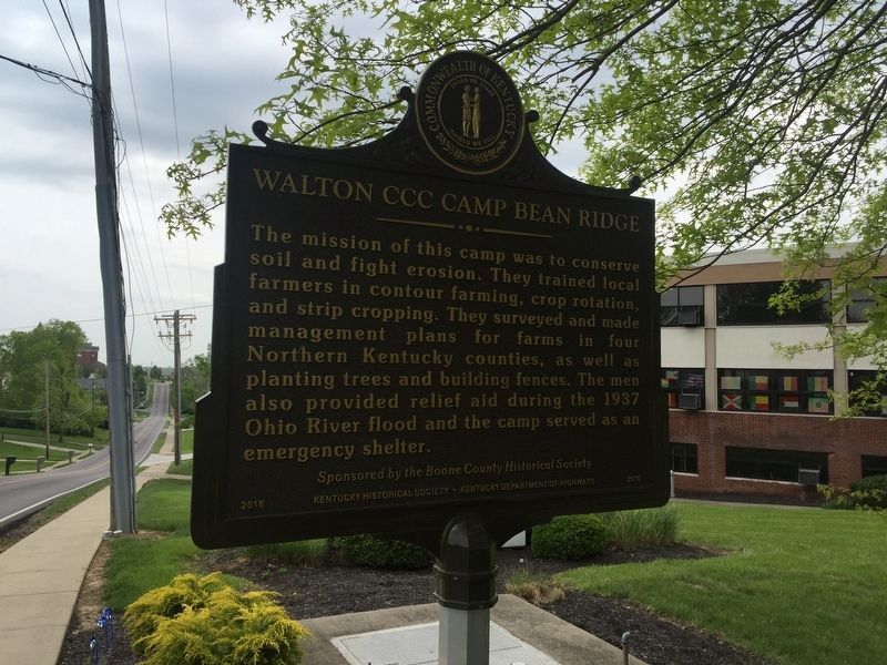
Civilian Conservation Corps (CCC) company
3541 began here in July 1935 on a former ball
park site owned by John L. Vest. Known as
Camp Bean Ridge to the 200 men stationed
here, it was 1 of 44 CCC camps in Kentucky
In all, more than 89,000 . . . — — Map (db m133269) HM
Death site of Edward Boone, a brother of renowned Kentucky pioneer Daniel Boone. Edward was killed by Indians here Oct 1780 at age 40 while hunting with Daniel. Boone Creek named for Edward. Daniel and Edward wed sisters, Rebecca and Martha Bryan, . . . — — Map (db m171825) HM
Established in 1867 under Rev. Thomas Gant after members left the fellowship of First Baptist Church, Paris, Rev. Elisha Green, pastor. Current church structure of wood mold brick built in 1904. Membership includes descendants of the original . . . — — Map (db m170051) HM
Born in Millersburg, Kidd devoted much of her life to civil rights causes. Served as representative in Ky. state legislature, 1968-85, earning her nickname, “Lady of the House.” Kidd led Ky.'s ratification of 13th, 14th, and 15th amendments to . . . — — Map (db m123690) HM
Alexander House
The federal style house was built for William W. Alexander, a state representative 1848-52. His father, William Alexander, owned a hemp factory until 1856, which was operated by 100 enslaved people. At 600 feet, it had one of . . . — — Map (db m170055) HM
Named for the royal French family who aided the colonies in the War of Independence. Bourbon was one of nine Virginia counties formed before Kentucky became a state in 1792. From its original area all of twenty-four counties and parts of ten other . . . — — Map (db m43621) HM
Bourbon Whiskey
Named after Bourbon Co. because of quantity and quality of whiskey produced within its borders. Made from a fermented mash of at least 51% corn, with less wheat, rye, or barley, yeast and limestone water. Distilled at no more . . . — — Map (db m35597) HM
Built by Presbyterians, 1791. Here Barton W. Stone began his ministry, 1796. Famous revival attended by pioneers of many faiths, 1801. Springfield Presbytery dissolved and "Christian Church" launched, June 28, 1804. — — Map (db m9724) HM
Colville Covered Bridge Built in 1877, this bridge spans Hinkston Creek. It is of Burr truss construction, which is the multiple king post type. The single span is 124 feet long and 18 feet wide. It was restored by Louis Bower in 1913 and by . . . — — Map (db m171786) HM
This log building lined with adz-hewn cherry was built as a tavern. In 1795 it became first post office in Paris. Thomas Eades then served as tavern owner and postmaster. Robert Trimble had home and law office here before becoming U.S. Supreme Court . . . — — Map (db m43626) HM
Sites of birthplace of Garrett A. Morgan, and Branch School, which he attended, are ¼ mile south. He invented the tri-color traffic signal, forerunner of the present type, and a gas mask worn in rescue work at Cleveland, Ohio, 1916. His mask was the . . . — — Map (db m170056) HM
First Christian Church organized 1827 by Thomas Allen, John Gano, and six "brave and forthright" women. Part of movement led by Barton W. Stone out of 1801 Cane Ridge Revival promoting Christian unity on New Testament authority. Prominent from its . . . — — Map (db m170054) HM
Frankfort & Cincinnati Railroad
Built 1888-90 as the Kentucky Midland Railroad, it spanned 40 miles from Frankfort to Paris. Had connections on both ends to the L&N. Name changed to Frankfort & Cincinnati in 1899, but it had no connections . . . — — Map (db m170050) HM
This lawyer, state legislator, and congressman, who played leading role in preventing 1861 secession of Kentucky, lived 1 block north. Davis represented Bourbon Co. in legislature. In Congress, 1839-47, 1861-72; Ky. Const. Conv., 1849. A Whig ally . . . — — Map (db m170079) HM
Hopewell, one of the oldest Presbyterian churches in Bourbon County, has held worship services since 1785. The first congregation included Dutch settlers. It was recognized by the Transylvania Presbytery in 1787. Original church was located near . . . — — Map (db m218204) HM
John Edwards 1748-1837
As early legislator, Edwards was member of the Virginia House of Delegates in 1781-83, 1785, 1786. He was a delegate to the convention to ratify Federal Constitution, June 1788, and to conventions that separated . . . — — Map (db m43623) HM
Robert Johnston, a Revolutionary War captain, was born in Virginia in 1749. He and his wife operated a tavern in their house here from 1796-1812. Located on what was the main road between Maysville and Lexington, this inn served stage and horseback . . . — — Map (db m67703) HM
Site of birthplace and early home of John Fox, Jr., famous Kentucky author, born 1862, graduated from Harvard in 1883. Died, 1919. Focusing on life in the Appalachian area, he wrote 12 novels and 45 short stories, including The Little Shepherd of . . . — — Map (db m170082) HM
Near his home Isaac Ruddell built a gristmill in 1788 on the north side of Hinkson bridge, and a sawmill in 1795 to be operated by his son, Abram. A 720-spindle cotton mill erected 500 feet west by Thomas and Hugh Brent in 1828, burned 1836. Soon . . . — — Map (db m171782) HM
Organized by 20 members of the Cooper's Run Church in 1800, with the help of Ambrose Dudley, George Eve and Augustine Eastin. They built at this site on land given, 1798, by Charles Smith, Sr. The log structure was replaced by a brick house of . . . — — Map (db m35860) HM
Built of two-foot blue ash logs as home by Daniel Matheny, 1790. With Jacob Leer as class leader Mt. Gilead Methodist Society was organized here by Reverend Caleb Jarvis Taylor, author of revival hymns. Members were not allowed to buy slaves except . . . — — Map (db m218137) HM
Originally a 1,400 acre land warrant, Townsend Springs was settled by John Townsend in 1775-1776. With Capt. John Hinkston Townsend traveled Ohio River exploring Shawnee territory. Named Townsend Creek in 1776. Townsend raised corn, sold to . . . — — Map (db m170052) HM
Settled by 1799 by members of the Poage family of Virginia. Known as Poage's Landing until named in 1854 for Henry Clay's Lexington estate, by the owners, Ky. Iron, Coal and Manufacturing Company. It engaged M. T. Hilton to lay out a town, then . . . — — Map (db m59244) HM
In 1894 Ashland Board of Education assumed management of “Negro School,” where African American William Reynolds was principal. In 1901 a bond issue passed with support of blacks and Superintendent J.G. Crabbe. School board then funded . . . — — Map (db m127190) HM
NORTON FURNACE. In 1967, the world’s oldest known operating blast furnace. Built by Norton Iron Works Co. in 1873, an iron shell stack 67 ft. high with maximum inner diameter of 18 feet, burning “stone coal.” It produced 10,502 tons . . . — — Map (db m128281) HM
Organized June 11, 1819, at home of Maj. Jas. Poage, north of this spot, as Bethesda Presbyterian Church by Rev. Robert Wilson with 20 members. First a mile SW on Pollard Rd.; moved 1828 to Beech Grove, ½ mile W. and in 1858 to this corner . . . — — Map (db m59242) HM
This stadium served the Ashland Public Schools. Built in 1937 for $6,500 as a WPA project, it was dedicated on Thanksgiving Day that same year. The Ashland High School Tomcats record of success includes 11 state championships. In 1944, the Tomcats . . . — — Map (db m73802) HM
USA post located here to protect Ohio River traffic. Became supply base and communications center for Union forces in the Big Sandy region. In winter 1861-62 troops under Col. J.A. Garfield, later 20th President U.S., drove CSA from area by victory . . . — — Map (db m73765) HM
For Linn Boyd. Born Tenn., 1800. Came to West Ky. in youth. Ky. Legislature, 1827-31. Congress, 1835-37, 1839-55, and Speaker 1851-55. Author of Resolution to annex Texas. The Ky. delegation proposed Boyd for Vice President at Democratic Convention, . . . — — Map (db m73754) HM
James H. McCoy. Oldest son of Randall and Sarah. Last living McCoy feudist before passing away in 1929. He was a peacemaker in the feud and tried to talk Frank Phillips out of killing Jim Vance & Bill Dempsey. In 1928, James & Tennis Hatfield, . . . — — Map (db m126114) HM
Buena Vista Furnace Built by William Foster and Co. in 1847, 2¼ miles west, named for Mexican War battle that year. It was an important factor in the Hanging Rock iron industry until dismantled in 1876. Its 1874 production was 4113 tons. Stone . . . — — Map (db m126266) HM
Princess Furnace. Built here in 1876-77 by Thomas W. Means (1803-90), for 50 years the leading figure in the iron industry of this area, owner of furnaces in Kentucky, Ohio, Virginia, Alabama. This iron-jacketed stack burned “stone . . . — — Map (db m126230) HM
Clinton Furnace. Stood one mile east. Its stone stack was 10 ft across inside, about 35 ft. high, built in 1832 by George, William Thomas H. and Hugh A. Poage. In 270 days of 1838 it used 2992 tons of ore, 247,000 bushels of charcoal to make . . . — — Map (db m126229) HM
Sandy Furnace. Built 1853 by Young, Foster & Co
(Dan and John Young, William Foster,
Irwin Gilruth), 4 miles west on a
9,000 acre tract. Stone stack
originally 32 ft. high, 10½ ft.
across inside. In 1854, its last
year of operation, . . . — — Map (db m126132) HM
Colorful college football coach and National Baseball League umpire. Coached Praying Colonels of Centre College into national football spotlight, 1916-23. See other side. First coached, 1898-99, at Bethel College, Russellville, Ky. Then held four . . . — — Map (db m121575) HM
In this block a thriving African American business district stood for over 100 years. Restaurants, barber and beauty shops, medical and dental offices, and retail shops drew patrons from Boyle and nearby counties. Until razed by urban renewal in . . . — — Map (db m49741) HM
Homesite and grave 1 mile west. B., Orange Co., Va., 1740. D., 1825. 40 years service to his country. Lt. at Fort Pitt, Dunmore's War, 1774. Captain, Botetourt County militia, 1776. Northwest Campaign of George Rogers Clark, 1778. Came to Ky., 1781. . . . — — Map (db m120112) HM
Founded on this campus in 1819 by pioneer Kentuckians who held that heart and mind must be trained together, and dedicated to the inculcation of ideals of culture and character in the hearts of American youth. Veritas Lux Mentis. — — Map (db m121562) HM
Early pioneer settlement erected before 1779. Developed by George Clark, brother-in-law of William Whitley, whose party came to Ky. about 1775. Located on Clark's Run Creek, named for George Clark, it was one of the first stations built in the . . . — — Map (db m105411) HM
For Judge John Boyle, 1774-1834. State representative, 1800; U.S. Congress, 1803-9; Kentucky Court of Appeals, Chief Justice, 1810-26; U.S. District Judge for Kentucky, 1826-34. The Judge "lived for his country," setting many important legal . . . — — Map (db m121555) HM
Boyle County's first courthouse erected here, 1842, destroyed by great fire of 1860. This building completed 1862. First occupied by Union forces as hospital after battle of Perryville, October 8, 1862.
On 11th a Union force drove CSA from . . . — — Map (db m121556) HM
Burial site of Ephraim McDowell, the “father of modern surgery.” His family moved here from Va. in 1784. He studied medicine in Va. and Scotland before practicing in Danville. In 1802, he married Sarah Shelby, dau. of Ky.’s first gov. . . . — — Map (db m50814) HM
Obverse
Home of Ephraim McDowell, the “father of modern surgery.” Here on December 25, 1809, McDowell performed the first successful abdominal operation when he took a 22-pound ovarian cyst from Jane Todd Crawford of Green . . . — — Map (db m71047) HM
On June 1, 1916, representatives of local churches, civic clubs and Centre College, inspired by Hull House and the Progressive Era, founded the Community Work Board (CWB), which made social work scientific, opposed begging; gave coal, meals, and . . . — — Map (db m170098) HM
Kentucky's first recorded hemp crop, 1775, was on Clark's Run Creek, near Danville. Grown by Archibald McNeill, who brought the first seed with him when he located here. Hemp production spread slowly throughout the area, but Boyle County later . . . — — Map (db m121560) HM
May 23, 1864, nearly 250 black men, most of them slaves, left Boyle Co. to march to Camp Nelson in Jessamine Co. to enlist in the Union army. On the way, some Danville citizens threw stones and shot pistols at the recruits. When they reached . . . — — Map (db m70996) HM
Stephen Albert Fisher, Rev. War soldier from Va., assigned in 1775 to active duty and wounded while serving with Colonel John Bowman's militia. Returned to Ky. in 1779 with wife Mary Magdalene Garr. He established garrison of military significance . . . — — Map (db m70981) HM
Mansion built by William Owsley at close of term as Governor of Kentucky, 1844-48. Tract on which house stands part of land claimed by James Harrod prior to 1785. Owsley (1782-1862) served as Judge on the Court of Appeals, State Senator, and . . . — — Map (db m153067) HM
Danville's first tavern, operated in this building before 1800 by Benjamin Grayson. Often within these walls the burning political issues of the day were discussed. The Danville Political Society, organized in 1786 and the first of its kind in the . . . — — Map (db m49742) HM
Kentucky School for the Deaf first opened 1823 in Danville, at 4th and Main Sts. In 1826, it moved to this campus. Jacobs Hall is oldest surviving building, constructed 1855-57, of Italianate design by architect Thomas Lewinski. Its interior is . . . — — Map (db m121561) HM
Born in Boyle Co. and a graduate of Centre College, 1850, Harlan practiced law in central Ky. after 1853. Although against Lincoln and abolition in 1860, he was a strong Unionist during Civil War; recruited 10th Ky. Infantry. Elected Attorney . . . — — Map (db m121559) HM
Abraham Lincoln’s friend and 1st law partner was born on Nov. 10, 1807, in Fayette Co. The son of a Presbyterian minister & Mary Todd Lincoln’s aunt, Stuart graduated from Centre College in 1826. Two years later he became a lawyer in Springfield, . . . — — Map (db m49746) HM
Side 1 Original site of Bate High School, built 1912 and named in honor of its founder, John William Bate. Born a slave in Louisville, Bate received an AB from Berea College in 1881 and and AM in 1891. He moved to Danville to teach in 1881 . . . — — Map (db m105414) HM
In December 1806, William Clark, coleader of the Lewis and Clark Expedition to the Pacific Ocean, visited his nephews in school in Danville. Clark was en route to Washington to report to President Jefferson and other government officials about the . . . — — Map (db m49744) HM
This dynamic Southern Baptist missionary spent almost forty years (1873-1912) teaching and ministering in China. She was a member of First Baptist Church, Danville, 1868-71, and taught at Caldwell Female Institute, later a part of Centre College. . . . — — Map (db m153068) HM
Old Crow Inn
The oldest existing stone house in Kentucky, built 1784, is part of this building. The house has been enlarged and Doric pillars added. Land purchased from John Crow by James Wright, 1781. Next owner, Colonel Joshua Barbee, who . . . — — Map (db m105413) HM
Reverend Francis Clark organized first Methodist Soc. in Ky., 1783; such groups formed Methodist Episcopal Church, established 1784. Clark, from Virginia, settled near here. A local preacher, he was assisted by John Durham, lay leader. Society, led . . . — — Map (db m170100) HM
(side 1)
Poet, Lawyer and Soldier
Theodore O'Hara was born in this city, Feb. 11, 1820. He read law with Judge Wm. Owsley. Newspaper work included editing Frankfort Yeoman and Louisville Times. He served in Mexican War, . . . — — Map (db m121558) HM
One of three founded, 1784, by Reverend David Rice; earliest of this denomination west of Alleghenies. Here worshipped: James G. Birney, whose presidential candidacy in 1844 caused defeat of Henry Clay; John C. Breckinridge, whose 1860 candidacy . . . — — Map (db m121839) HM
On this corner, in 1823, Kentucky founded the first state-supported school in the United States for the instruction of deaf children. Classes met in an old inn that was known as the Yellow House. Reverend and Mrs. John R. Kerr served as first . . . — — Map (db m121541) HM
Referred to by geologists as a “karst window”, sinking springs form when bedrock has collapsed to reveal groundwater moving through an aquifer. Water flows from the spring, creates a surface-flowing stream, and returns underground. This . . . — — Map (db m121572) HM
Kentucky District Court sessions held here March 14, 1785, until Court of Appeals set up in 1792. Created by Virginia statute on May 6, 1782, the court first met in Harrodsburg on March 3, 1783. Later meetings at Low Dutch Station and John Crow's . . . — — Map (db m121534) HM
Founded Danville, 1781. First Atty. Gen. of Ky. District, 1783. As a member of Commission went to Falls of Ohio to allot lands in Clark's grant to members of Ill. Regt. Daniel was killed by Indians, Aug. 1784, on way to visit brother at Bullitt's . . . — — Map (db m49743) HM
Willis Russell, a well-educated & emancipated slave of Rev. War captain Robert Craddock, relocated from Warren Co., Ky. to Danville around April 1838. He taught black children in this pre-1795 log home that he inherited when Capt. Craddock died in . . . — — Map (db m121564) HM
Isaac Shelby, 1st & 5th governor, came to Ky. as a surveyor in 1775. He claimed 1400 acres in 1776 by raising a crop of corn. In 1779 he received 1st land settlement & premption deed granted by Va. Land Commission. His home, Traveler's Rest, . . . — — Map (db m120115) HM
(left panel)
The battle was brought on by Confederate Lieut. Gen. Braxton Bragg as a delaying action to insure safe withdrawal of a huge wagon train of supplies and to enable him to effect a junction with the army of Maj. Gen. E. Kirby . . . — — Map (db m46239) HM
October 8, 1862 Here 16,000 Confederates under General Braxton Bragg fought 22,000 Federals under General Don Carlos Buell. Bragg, facing superior forces, withdrew.Union casualties 4211; Confederate, 3396. — — Map (db m5193) HM
Here 16,000 Confederates under General Braxton Bragg fought 22,000 Federals under General Don Carlos Buell. Bragg, facing superior forces, withdrew. Union casualties, 4211; Confederate, 3396. — — Map (db m55026) HM
October 8, 1862. Here 16,000 Confederates under General Braxton Bragg fought 22,000 Federals under General Don Carlos Buell. Bragg, facing superior forces, withdrew, Union casualties, 4211; Confederate, 3396. — — Map (db m68552) HM
Owned by Squire H. P. Bottom, it was a key position in Battle of Perryville, Oct. 8, 1862. At the beginning of battle, held by USA troops. After a massed attack, Confederates took the house and held it. The battle over, Bottom identified and buried . . . — — Map (db m167646) HM
Used by Confederate Gen. Braxton Bragg as headquarters during the Battle of Perryville, Oct. 8, 1862. Crawford Spring, back of the house, furnished vital water supply to CSA troops on the drought stricken battlefield. — — Map (db m46248) HM
As Confederate and Union armies converged over to the west the day and night before great Battle of Perryville, Oct. 8, 1862, there was constant fighting for water. Almost unprecedented drought had made water so scarce that troops contended for . . . — — Map (db m68319) HM
(obverse)
Karrick-Parks House
Bivouac for Confederate troops on Oct. 7, 1862, night before Battle of Perryville. Karricks ordered to vacate home the next day. Day after the battle they returned to survey damage, found little done. . . . — — Map (db m46396) HM
Near here was the home of Charles King and Caroline Purdom Kirkland. To escape the Battle of Perryville, they traveled with their 3 young children 10 miles south to the home of Caroline’s father in Forkland. When they returned a few days later, they . . . — — Map (db m68320) HM
(obverse)
Merchants' Row
Originally known as Main St., the town's historic commercial center renamed Buell St. to honor Union general D.C. Buell. Now called Merchants' Row, most buildings built 1830-40. Temperance leader Carrie . . . — — Map (db m46399) HM
Established as Harberson's Fort before 1783 by James Harberson, Thomas Walker, Daniel Ewing and others at the crossroads of Danville-Louisville and Harrodsburg-Nashville routes. Town laid out by Edward Bullock and William Hall, 1815, named for . . . — — Map (db m46400) HM
On the knoll, it was a key position on the Union left flank under Maj. Gen. McCook in Battle of Perryville, Oct. 8, 1862. The scene of desperate fighting, it changed hands twice and was hit many times. After the battle it was used as a hospital. — — Map (db m46355) HM
W. H. Rogers, president of Inter-County R.E.C.C., threw the switch at the Perryville substation on June 10, 1938, to energize 56 miles of line to 115 homes. In 2013, on the 75th anniversary of this event, Inter-County Energy served more than 25,000 . . . — — Map (db m68402) HM
Stephen Collins Foster, as youth, visited here, May 1833. His uncle, Dr. Joseph S. Tomlinson, was then President of Augusta College. The musical, harmonious voices from the old Negro church on the hill floated softly over the town. “It can . . . — — Map (db m136271) HM
In 1822 the trustees of Bracken Academy with conferences of the Methodist Church of Kentucky and Ohio, merged to found Augusta College. The first established Methodist college in the world. — — Map (db m85801) HM
By Sept. 1862 6,000 Union troops had gone from this district. Only 100 Home Guards left, under Col. Bradford. On Sept. 27, Col. Duke with 350 Morgan Raiders attacked. Guards secreted in houses fought until Raiders penetrated area, burned and . . . — — Map (db m85877) HM
During the 1870s, leading wine-producing county of US, furnishing over 30,000 gallons annually, half the entire national production. Germans, finding soil here similar to that in France and Spain, brought grape cultivation and wine production to . . . — — Map (db m136283) HM
Formed from parts of Campbell and
Mason. Named for William Bracken,
hunter, fisherman, Indian fighter,
came here 1773. Birthplace of John
Gregg Fee, founder of Berea College,
1855. Birthplace and home of Dr.
Joshua Taylor Bradford, . . . — — Map (db m136282) HM
Captain Philip Buckner, an Englishman, was a Revolutionary War veteran. He came to Va., served adopted colony as issuing commissary, received extensive land grants, then settled here. In 1797, he donated this lot for Augusta Public Square as part of . . . — — Map (db m86656) HM
Fort Ancient Village at Augusta Augusta is located on the site of a major settlement of the Fort Ancient people, who lived here between AD 1500 and 1650. The village consisted of large communal houses built around a central plaza. Archaeologists . . . — — Map (db m217822) HM
A rare example of a one-room schoolhouse. First through eighth grades, with about 25 children per year, were taught by one teacher. This schoolhouse was used until 1929. In Kentucky there were an estimated 6,752 one-room schoolhouses in 1901, and . . . — — Map (db m136270) HM
Walcott Covered Bridge This scenic bridge, also known as The White Bridge, is a 75-foot span over Locust Creek and has served Walcott community from 1824-1954. It is of King and Queen type, timber truss construction with hand-hewn joints and . . . — — Map (db m217818) HM
In summer of 1793 Indians crossed Ohio River, hid canoes at mouth of Holt’s Creek, site of Foster, and proceeded to Bourbon County to steal horses. Simon Kenton secured a small group to ambush them on their return. After lying concealed for four . . . — — Map (db m136268) HM
John Gregg Fee. Fee received degree from Augusta
College; went to Lane Theological
Seminary. Had spiritual experience
which began career as nationally
known and determined abolitionist.
A founder of Berea College who
wanted low-cost . . . — — Map (db m136344) HM
The courthouse that stood here, 1899-1963, was a landmark of Kentucky's "feudin' 'n' fightin'." Stemming from Civil War, feuds and political disagreements, unnumbered slayings, ambushes, and assassinations occurred between 1870-1920. In 11 months, . . . — — Map (db m73893) HM
During the Civil War animosity between Union and Confederate sympathizers in Breathitt County led to deaths of 20 citizens and 44 CSA and USA men discharged or on furlough. They were killed in personal fights, ambushes, or by murders at their homes. . . . — — Map (db m146468) HM
Formed from parts of Estill, Clay, Perry Counties, 1839. Named for Gov. John Breathitt, who died in office, 1834. Breathitt born in Va. 1786. Family came to Logan County, Ky. 1800. Representative Ky. Legis. 3 terms, Lt. Gov. 1828, Gov. 1832-34. . . . — — Map (db m73891) HM
During World War I, this county attained national prominence by filling its quota of service men by volunteers. No men had to be drafted from Breathitt, the only county in U.S. with this record. During war 3,912 men registered, 405 volunteered, 324 . . . — — Map (db m73892) WM
Samuel VanderMeer came here from New Jersey in 1923. “Uncle Sam” to generations of Ky. Youngsters, he became pastor of the Morris Fork Presbyterian Church in 1927, the year he married nurse Nola Pease. Missionaries, community builders. . . . — — Map (db m39151) HM
Part of Company I, 14th Kentucky Infantry, USA, attacked Confederates camped here, night of April 5, 1864. CSA loss: eight killed or wounded, three prisoners and 24 horses taken.
Gen. John H. Morgan’s CSA men, on tragic last raid into Kentucky, . . . — — Map (db m146426) HM
Cloverport, an important shipping point beginning in 1798 when Joe Houston came from Va.: built home and started trading and shipping business. Flatboats carried Ky. tobacco, other goods for sale in New Orleans. Boats sold as lumber. Men came back . . . — — Map (db m160276) HM
Four miles south. A fashionable health resort of 1840s which had the unique attraction of a 100-foot cliff from which tar bubbled while from its base flowed eleven springs, each with different type of mineral water. Indians knew and used these . . . — — Map (db m160289) HM
Six miles north are birthplace and grave of Joseph Holt, 1807-1896. He was commissioner of patents, postmaster general, and secretary of war in President Buchanan's administration, 1857-1861. Lincoln named him judge advocate general of the Union . . . — — Map (db m160290) HM
This is birthplace and grave of Joseph Holt, 1807-96. He served as Commissioner of Patents, Postmaster General, and Sec. of War in Pres. Buchanan's Administration. 1857-61.
Lincoln named him Judge Advocate General of the Union army in 1862. Holt . . . — — Map (db m160293) HM
1845 entries matched your criteria. Entries 101 through 200 are listed above. ⊲ Previous 100 — Next 100 ⊳