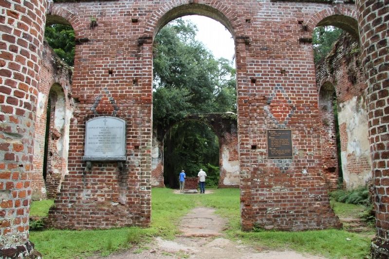
Near Old Sheldon Church Road north of Trask Parkway (U.S. 21), on the right when traveling north.
Church of Prince William's Parish
known as
Sheldon
Built Between 1745-1755
Burned By the British Army 1779
Rebuilt 1826
Burned By the Federal Army 1865 — — Map (db m106086) HM
On Old Sheldon Church Road near Trask Parkway (U.S. 21), on the right when traveling north.
These ruins are of Prince William's Parish Church, built ca. 1751-1757 and partially burned during the American Revolution, with its interior and roof rebuilt 1825-26. This Anglican church was primarily paid for by Lieutenant Governor William . . . — — Map (db m106077) HM
On Old Sheldon Church Road north of Bailey Road, on the right when traveling north. Reported permanently removed.
Built 1745-55. Burned 1779 by British. Rebuilt 1826. Burned 1865 by Federal Army. Named for ancestral home of the Bull family in Warwickshire, England.
Annual Services
Second Sunday after Easter — — Map (db m26366) HM
On Trask Parkway (U.S. 17 / 21) 0.1 miles north of Sheldon Drive when traveling north.
Sheldon Union Academy. Sheldon Union Academy, later Sheldon School, opened in 1893 on this site and educated the black children of rural Sheldon community for almost fifty years. The original Sheldon Union Academy board, which . . . — — Map (db m5785) HM
Near Old Sheldon Church Road north of Trask Parkway, on the right when traveling north.
William Bull
of Sheldon
Born 1683 Son of Stephen Bull,
the Immigrant
Member Colonial House of Commons
1706 - 1719
Colonel of Berkeley County Regiment
Tuscarora and Yemassee Wars.
Lord's Proprietors Deputy 1719.
Member and President . . . — — Map (db m106135)
On Charleston Highway (U.S. 17) near Boat ramp driveway, on the right when traveling south.
Combahee River Raid
On June 1-2, 1863, a Federal Force
consisting of elements of the 2nd
S.C. Volunteer Infantry (an African-
American unit) and the 3rd Rhode
Island Artillery conducted a raid
up the Confederate-held Combahee
River. . . . — — Map (db m66105) HM
On Ace Basin Parkway (U.S. 17) at Clover Hill Road, on the right when traveling north on Ace Basin Parkway.
A brick Chapel of Ease for St. Bartholomew's Parish was built here in 1758 in a town laid out in 1740 and named for Landgrave Edmund Bellinger. The Vestry reported the Chapel unfit for use in 1786, and in 1810 it fell in ruins. A new Chapel built . . . — — Map (db m220036) HM
On Oyster Row Lane 0.5 miles south of Palmetto Road, on the right when traveling south.
In the 1840s, the U.S. Coast Survey finally began the first-ever accurate mapping of our coasts. The agency's superintendent, Professor Alexander D. Bache, great grandson of Benjamin Franklin and West Point roommate of Jefferson Davis, was a . . . — — Map (db m208402) HM
On Oyster Row Lane 0.5 miles south of Palmetto Road, on the right when traveling south.
You understand how important safe airports, roads and shipping lanes are today. President Thomas Jefferson understood the same thing in 1807 (except tor the airports!) when he approved a survey of America's coastline to aid in navigation.
To . . . — — Map (db m208406) HM
On Oyster Row Lane 0.5 miles south of Palmetto Road, on the right when traveling south.
Placed here in 1850, this granite monument marks the western end of the Edisto baseline. Its mate still stands 6.68 miles east of this spot. They are among the few surviving end-point monuments of the seven baselines the U.S. Coast Survey measured . . . — — Map (db m208412) HM
On Oyster Row Lane 0.5 miles south of Palmetto Road, on the right when traveling south.
As you look at the dense maritime forest around you, imagine using only hand tools to clear a swath through that formidable vegetation. That's what faced faced Alexander Bache's assistant, Charles Boutelle, when he arrived at Edisto to prepare the . . . — — Map (db m208407) HM
On Bennetts Point Road south of Ashepoo Siding, on the right when traveling south.
On May 23-24, 1864, Union forces attempted an amphibious operation to destroy a railroad trestle across the Ashepoo River. Soldiers from the 34th U.S.C.T were carried up the Ashepoo on the steamer Boston. The boat was grounded on an oyster . . . — — Map (db m115202) HM
On Ace Basin Pkwy (U.S. 17) 0.1 miles south of Green Pond Highway (State Highway 303), on the left when traveling north.
On top of this ridge stood a sylvan temple erected before the Revolution by Colonel Barnard Elliott, patriot and sportsman. The structure was supported by columns in the classic manor. The site, a part of Colonel Elliot's plantation "Belleview," . . . — — Map (db m7869) HM
On Hendersonville Highway (U.S. 17A), on the right when traveling north.
Hendersonville
Settled in 1791 and known as Godfrey Savannah, this area later was the summer home for a colony of Combahee River rice planters. The settlement, known as Hendersonville by 1862, was named for Dr. Edward Rogers Henderson, a . . . — — Map (db m7028) HM
On Hendersonville Hwy , US 17 A, on the left when traveling north.
This was formerly the site of a
Presbyterian church organized in
1766 by the Reverend Arichibald
Simpson, minister from Scotland.
The church was incorporated on
December 17, 1808. Serving the
church were the Reverends Simpson,
Edward . . . — — Map (db m7118) HM
On Ritter Road (State Highway S-15-41) near Catholic Church Creek Road, on the left when traveling east.
In tribute to all those who, casting away the shackles of servitude and the humiliation of bondage, accepted the sweet yoke of Christ and the light burden of his teachings in the Holy Catholic Church founded by Jesus upon Simon Peter the Apostle, . . . — — Map (db m7885) HM
On Ritter Road (State Highway 15-41) 0.1 miles west of Catholic Hill Creek (State Highway 15-436), on the left when traveling east.
Settlers from Ireland of the Roman Catholic faith in this area helped form the ecclesiastical territory of Colleton, Beaufort, and Barnwell Districts under Bishop John England in 1831. The Church of St. James the Greater was dedicated on this site . . . — — Map (db m7883) HM
On Aviation Way, on the right when traveling north.
(Anderson Field side):
This airfield, the first in Colleton County, was built and dedicated in 1933 on 60 acres leased to the town of Walterboro by the estate of C.C. Anderson, foe whom it was named. By 1937 the town purchased the field and . . . — — Map (db m4290) HM
This church, originally located at Jacksonboro, was founded in 1728 by Rev. Archibald Stobo (d.1741), father of the Presbyterian church in S.C. The first building at Jacksonboro was replaced in 1746 by a "hansome sanctuary" that stood until it . . . — — Map (db m7117) HM
On Hampton Street at South Walter Street, on the left when traveling east on Hampton Street.
The original section of this courthouse, completed in 1882 after the county seat moved to Walterboro from Jacksonborough, was built by contractor William Thompson. The front portico is attributed to Robert Mills, who completed an unfinished design . . . — — Map (db m7063) HM
Short and tall, rich and poor,
black and white, farmer and
shopkeeper - they came from
every walk of life. The men and
women of Colleton County have
always answered the call to
defend the flag and protect
our freedom.
They have done this . . . — — Map (db m7150) WM
On Hampton Street (South Carolina Route 63) east of North Memorial Avenue, on the left when traveling east.
In the Fall of 1968, the Colleton Rural Fire Department was organized. A 1958 school bus service truck was donated to the fire department. With the help of the volunteer firemen, it was converted into the first fire truck to be used in District . . . — — Map (db m301413) HM
On Gruber Street at Ackerman Street, on the right when traveling west on Gruber Street.
Colleton Training School. Colleton Training School opened in 1925 and served African American students in the elementary and high school grades. In 1954 it was renamed Colleton High and remained in use until 1970 when Colleton County schools . . . — — Map (db m301415) HM
(Front face):To the Confederate soldiers of Colleton County, SC
To those who fought and lived
To those who fought and died
To those who gave much
And to those who gave all
(Rear face):
To the mothers, wives, sisters and . . . — — Map (db m7064) HM
On Fishburne Street (U.S. 1) at Wichman Street (Alternate U.S. 17), on the left when traveling north on Fishburne Street.
In 1784, brothers Paul and Jacob Walters, seeking refuge from the malaria-ridden rice swamps of the coast, found relief in the pinelands of this area. Here they constructed log cabin summer homes immediately north of where you're standing and to the . . . — — Map (db m200600) HM
On Wichman Street, on the right when traveling west.
Near here in a hickory grove Paul and Jacob Walter built in 1784 summer houses which formed the nucleus of a summer colony which grew into the town of Walterboro. The first store in the town was here and later the first drug store. The park here was . . . — — Map (db m7112) HM
On Jeffries Highway (U.S. 15) at Pleasant Grove Road, on the left when traveling north on Jeffries Highway.
The cemetery one-half mile west is on the site of a meeting house deeded to the Methodist Society by John Fontaine in 1802. Bishop Francis Asbury had held services at Island Creek on March 4, 1796, in "a pole house." In 1882 the members had moved to . . . — — Map (db m176608) HM
On Aviation Way near Lt.Col. Hiram Mann Driveway, on the right when traveling north.
During World War II over 400,000 German and Italian POWs were quartered in camps across the United States. In many cases the prisoners were used to fill vast labor shortages in production and agriculture. Their prisoner camps were small communities . . . — — Map (db m22627) HM
On Fishburne Street at Wichman Street (Alternate U.S. 17), on the right when traveling north on Fishburne Street.
St. Jude’s Episcopal Church
Walterboro
Historic District
The National Register
of Historic Places
South Carolina
Department of Archives
and History — — Map (db m200601) HM
On Wichman Street (Alternate U.S. 17) east of Fishburne Street, on the right when traveling east.
Tradition holds that this African Methodist Episcopal (A.M.E.) church first met after the Civil War before organizing in 1867 under Rev. James R. Nesbitt. It was part of the A.M.E Church's Walterboro Circuit, which Nesbitt formed in 1868. Members . . . — — Map (db m200426) HM
On Aviation Way, on the right when traveling north.
In 1945, the army deeded the Walterboro Army Airfield, previously known as Anderson Airfield, jointly to the City of Walterboro and Colleton County, including all surplus equipment. The Beacon (Aircraft Guiding Light) was left as part of the surplus . . . — — Map (db m7020) HM
On Aviation Way, on the right when traveling north.
In honor of the Tuskegee Airman, their instructors, and ground support personnel who participated in training for combat at the Walterboro Army Airfield during the Second World War.
Because of their heroic action in combat they were called . . . — — Map (db m4324) HM
On Aviation Way near Lt. Col. Hiram Mann Driveway, on the right when traveling north.
(Top left picture):
In April of 1944, Walterboro Army Airfield stopped training fighter groups and switched to advanced individual air combat training. Over 500 black airmen from the training program at Tuskegee trained at the airfield . . . — — Map (db m22611) HM
(Front text)
Graduates of the Tuskegee Army Flying School, who belonged to the first African-American units in the U.S. Army Air Corps, took further combat flight training at Walterboro Army Air Field from May 1944 to October 1945. Many of . . . — — Map (db m43420) HM
On North Jefferies Boulevard at East Wasghington Street on North Jefferies Boulevard.
Settled by Paul and Jacob Walter in 1784. Became a summer resort for Edisto, Combahee and Ashepoo planters. Incorporated in 1826. Since 1822 the County Seat of Colleton. In the court house was held, June 1826, the first Nullification Meeting under . . . — — Map (db m7084) HM
On Aviation Way near Lt.Col. Hiram Mann Driveway, on the right when traveling north.
"We were prisoners, but (we weren't made to) feel like prisoners. We were just people waiting to go back home"
- Helmut Ulbricht, German POW, Walterboro Army Air Field, 1945.The Press and Standard, 1994. Two Hundred and fifty German . . . — — Map (db m22631) HM
On Aviation Way at Lt. Col. Hiram Mann Drive, on the right on Aviation Way.
(Left Column)
Walterboro Army Airfield In the late 1920's and 1930's, a rough landing strip was made on the farm of C.C. Anderson just outside Walterboro. Starting in 1941, as part of the World War II effort,The U.S. Government . . . — — Map (db m22479) HM
On Aviation Way near Lt. Col. Hiram Mann Driveway, on the right when traveling north.
" Both white and negro troops will be stationed there, with negro troops to constitute about ten percent of the total personnel." - The Press and Standard, 1942
" A network of army air fields, used for training purposes and . . . — — Map (db m22562) HM
This neo-Gothic building, designed by Jones and Lee, noted architects of Charleston, and constructed by J.& B. Lucas in 1855-56, replaced the jail built in 1822 when Walterboro became the seat of justice of Colleton District. It served as a jail . . . — — Map (db m9970) HM
On Hampton Street (State Highway 63) near South Miller Street, on the right when traveling east.
Incorporated December 17, 1834, Walterborough Academy was the forerunner of the present city school system. Its trustees were Malachi Ford, John G. Godfrey, John D. Edwards, David Campbell, and Archibald Campbell. The Reverend John B. Van Dyke . . . — — Map (db m8665) HM
On Wichman Street, on the right when traveling west.
Marked geographic center of town
First location on present site of
St. Jude's Episcopal Church
Moved in 1845 to land given by
Richard B. Bedon
Now used by the
Colleton County Historical Society — — Map (db m7114) HM
On Cherry Grove Road (State Highway 25-621) 0.2 miles west of Harold Lane, on the right when traveling south.
This African-American church, a congregation of the Disciples of Christ, was founded in 1855 by members of Three Mile Creek Christian Church. A Rev. Ervin was its first pastor, and it met in a brush arbor before building its first sanctuary here. . . . — — Map (db m26015) HM
On Prince Williams Road (State Highway 25-512) east of Pond Town Road (State Highway 25-315).
Previously a branch of nearby Coosawhatchie Baptist Church (now Beech Branch), this church was constituted as a separate church in 1813 and takes its name from the parish in which it was located. Espousing Primitive Baptist principals, the church . . . — — Map (db m11500) HM
On November 7, 1872, a post office was established in this community, named for William E. Brunson, Sr., who donated the site. Brunson was chartered in 1874. The Town Hall, built in 1906, originally stood on stilts and covered the town's artesian . . . — — Map (db m11519) HM
On Sandy Run Road (State Highway 25-43) at Hickory Grove Road, on the right when traveling north on Sandy Run Road.
This church, founded by 1869 with Rev. G.D. Kinard as its first pastor and 22 charter members, was admitted to the Barnwell Association that year. The congregation first met in a brush arbor, then built a log church near this site. That building . . . — — Map (db m27162) HM
On Bamberg Road (U.S. 601), on the right when traveling south.
This area, called Whippy Swamp Cross Roads, was in Beaufort District before Hampton County was created in 1878. In 1840 the Whippy Swamp Guards of the 12th S.C. Militia built their “militia house” nearby. It hosted inspections, drills, picnics, . . . — — Map (db m43977) HM
On Keene Avenue at Nixville Road ( Route 3), on the right when traveling south on Keene Avenue.
Members of distant Lebanon Methodist Church held regular prayer meetings in Janie Boyd Rhodes's Estill home from 1902 until this church was built in 1908. Dr. W.M. O'Neal and his daughter Laura O'Neal Johnston donated the land here for a new . . . — — Map (db m287683) HM
On Clark Avenue 0.1 miles south of 5th Street, on the right when traveling north.
This church was founded in 1898 by residents of Estill and Lawtonville who were members of distant Presbyterian churches and desired to organize a congregation here. It held its first services in a school on Fourth St. the first permanent church, . . . — — Map (db m129258) HM
On Fourth Street at Lawton Avenue, on the right when traveling east on Fourth Street.
This Baptist Church, constituted in March 1775, was first situated on Pipe Creek in upper St. Peter's Parish near the Savannah River. Prior to 1836 it was moved to Lawtonville, where its building was used as a hospital by Union Forces in 1865. . . . — — Map (db m16476) HM
On Columbia Highway (U.S. 321), on the left when traveling north.
1922 Olympic Gold Medal winner Paris, France, while a student at Winthrop College. First woman in South Carolina Athletic Hall Of Fame. Outstanding educator at Columbia College. Daughter of William Asa and Lucie Ellerbe Godbold, Estill, South . . . — — Map (db m4767) HM
On Steep Bottom Road north of Bens Road, on the left when traveling north.
Steep Bottom Baptist Church was constituted in 1814 through the efforts of Rev. Hezekiah A. Boyd and Rev. James Sweat. Steep Bottom, along with Prince William and Cypress Creek Churches, was admitted into the Savannah River Baptist Association in . . . — — Map (db m287684) HM
On Columbia Highway (U.S. 321) at Nunn Street, on the right when traveling north on Columbia Highway.
Gifford Rosenwald School, sometimes Gifford Colored School, was built here in 1920-21. It was one of 500 rural schools built for African-American students in S.C., funded in part by the Julius Rosenwald Foundation from 1917 to 1932. The first of . . . — — Map (db m180063) HM
On 1st Street West (U.S. 601) north of Oak Street East, on the right when traveling north.
The Official Roster of South Carolina soldiers, sailors and Marines from Hampton County who died defending our country
World War I
1917-1918
Bennett, Eugene • Bowers, Charles E. • Buckner, Ben N. • Cochran, Dandy . . . — — Map (db m19814) WM
On Jackson Avenue near Hoover Street South, on the right when traveling north.
This 1933 cypress-log hut is the headquarters of American Legion Post #108. Legionnaires and other local citizens cut cypress trees for it, designed it, and built it, with funding from the Reconstruction Finance Corporation, a Depression-era . . . — — Map (db m39392) HM
On 1st Street East, on the left when traveling north.
The Bank of Hampton, built in 1892, was the first bank organized in Hampton and an important part of the rapid growth and development of the county seat from the 1890s to the mid-1920s. It was designed by Vincent Joseph Fontaine, a French-born . . . — — Map (db m35693) HM
On Holly Street West near Patrick Drive, on the left when traveling west.
Constructed for black students,this elementary school was built shortly after Hampton County School District purchased the land in the late 1920s. Two of the school's alumni of the 1930's and 1940s, brothers James F. and Julius C. Fields achieved . . . — — Map (db m19649) HM
On Elm Street (U.S. 278) near Lee Avenue, on the left when traveling west.
Established February 18, 1878, once a part of Beaufort District. It was named in honor of Wade Hampton, Lieutenant General C.S.A., Governor of South Carolina, 1876-79. United States Senator, 1879-91. Cornerstone of courthouse laid by Gen. . . . — — Map (db m6536) HM
This brick building was built in 1878-79 to house the Hampton County Jail. Its construction, as well as the building of the county courthouse, followed Hampton County's creation in 1878 from a portion of Beaufort County. Living quarters for the . . . — — Map (db m301358) HM
On Hoover Street South (U.S. 601) at Magnolia Street West, on the right when traveling north on Hoover Street South.
Huspah Baptist Church was organized c. 1873. The congregation first met in the homes of church members before erecting a permanent sanctuary. A two-room school was added to the property c. 1890 and was operated as a school for African American . . . — — Map (db m301360) HM
This house, built between 1878 and 1885, was the home of James Washington Moore (1837-1912), lawyer, Confederate officer, state legislator, and militia officer. Moore, a native of Gillisonville, was educated at the University of Ga. and returned . . . — — Map (db m26653) HM
On Jackson Avenue E near 1st Street East, on the right.
On this site stood the home of Miles Benjamin McSweeney (1854 - 1909 ), first Governor of South Carolina from Hampton County. He was the founder of the Hampton County Guardian, S.C. representative 1894 - 96, Lieutenant Governor 1897 - 99, . . . — — Map (db m9777) HM
On Pocotaligo Road (County Route 68) at Savannah Highway (U.S. 601), on the left when traveling south on Pocotaligo Road.
This was a major road in the northern part of old Beaufort District for many years, appearing in Mill's Atlas of 1825. Gen. Wm. T. Sherman used this route from Savannah, Georgia, to North Carolina in February of 1865 with much of his invasion . . . — — Map (db m4803) HM
On Hoover Street North (U.S. 601) near Plywood Street, on the right when traveling north.
Plywoods - Plastics Corporation. This complex, opened in 1942 as Plywoods - Plastics Corporation, has been significant in the industry and economy of Hampton and the lowcountry ever since. In 1941 Plywood Products Corporation bought this site . . . — — Map (db m65197) HM
On Mulberry Street W., on the right when traveling west.
Built 1911, by Town of Hampton.
Given to Hampton County 1925,
to become part of the county's
first public school system.
Closed 1954, upon consolidation
of district schools.
Building razed 1957.
This marker dedicated to our
school days, our . . . — — Map (db m7149) HM
On 1st Street West (U.S. 601) south of Elm Street West, on the right when traveling north.
In loving memory of those from this county who, as members of the Armed Forces of our country, made the supreme sacrifice that we may live in freedom…This living memorial of flowers is dedicated by us. — — Map (db m301356) WM
On 1st Street West (U.S. 601) south of Elm Street West, on the right when traveling north.
Dedicated to the memory of the Hampton County veterans that died in the Vietnam War
Sgt Joe W. Barnes •
PFC Wayne Crapse •
SSgt Walter Ferguson •
SFC Wilbur Greene, Sr. •
SP4 Lee A. James •
PFC Clark L. V. Williams
Pvt Lee . . . — — Map (db m301354) WM
On Hoover Street South, on the right when traveling north.
German prisoners of war were held in a camp on this site from September 1943 to the spring of 1946. This camp, one of 21 in S.C., was a sub-camp of Fort Jackson, in Columbia. 250 prisoners captured in North Africa were the first held here; later . . . — — Map (db m36557) HM
On Augusta Stagecoach Road (State Highway 25-20), on the left when traveling north.
This Baptist congregation, originally known as Savannah River, Carolina Church, was constituted near here March 1, 1775, mainly by members of Coosawhatchie (Beech Branch) Church. Rev. Joshua Lewis was its first known minister. In 1786, the church . . . — — Map (db m16037) HM
On Orangeburg Road (State Highway S-25-19) at State Highway S-25-20 on Orangeburg Road.
In old Lawtonville Community, across from this site, was the first Morrison Academy, a one-room elementary and college preparatory school. It was later moved 3.4 miles north of here on Orangeburg Road to be near the home of Rev. John Timothy . . . — — Map (db m10462) HM
On Yemassee Highway (South Carolina Route 68) east of Church Street South, on the right when traveling east.
Yemassee Rosenwald School. In 1929 Elvira Jackson sold 4 acres of land to Yemassee School District #26 for $500. The land was to be used to build an African American school and Yemassee Rosenwald School (Yemassee Colored School), a . . . — — Map (db m301352) HM
On Trask Parkway (U.S. 17/21), on the right when traveling east.
The Battle of Pocotaligo, the largest action of a three-day expedition intended to disrupt the Charleston & Savannah Railroad, took place nearby on October 22, 1862. With 2000 Confederates under Col. W.S. Walker defending the area between . . . — — Map (db m4776) HM
On Frontage Road 0.3 miles north of Gregorie Neck Road, on the right when traveling north.
On November 11, 1864, Union General W.T. Sherman would telegraph his Chief of Staff saying: "I would like to have Foster break the Charleston and Savannah Railroad about Pocotaligo about the 1st of December." It was his intention to cut off . . . — — Map (db m244739) HM
On Low Country Lane near Trask Parkway (U.S. 17). Reported permanently removed.
A large "earthwork," over 100 yards in length was raised on this site by General Robert E. Lee's troops c. 1862.
This fortification was a fall-back position from which to defend the Charleston to Savannah Railroad, an important supply line . . . — — Map (db m15398) HM
Near Kings Highway (U.S. 17) east of Yemassee Road, on the right when traveling east.
The black regiments that participated in the battle of Honey Hill were the 32nd (raised in Pennsylvania), the 35th (raised in North Carolina) and the roand (raised in Michigan), United States Colored Troops (USCT) and the 54th and 55th . . . — — Map (db m301326) HM
On Low Country Lane south of Kings Highway (U.S. 17), on the right when traveling south.
South Carolina's state tree, the Sabal Palmetto, thrives in sandy soils and coastal regions. This hardy palm can grow up to 65 feet tall and withstand both hurricane-force winds and brief periods of freezing temperatures, thanks to its flexible . . . — — Map (db m301340) HM
Near Low Country Lane south of Kings Highway (U.S. 17), on the right when traveling south.
A large "earthwork," over 100 yards in length was raised on this site by General Robert E. Lee's troops c. 1862.
This fortification was a fall-back position from which to defend the Charleston to Savannah railroad, an important line for the . . . — — Map (db m301329) HM
On Frontage Road east of Tulifinny Lane, on the right when traveling east.
General Robert E. Lee. Following the capture of Hilton Head, Beaufort, and the nearby sea islands in the fall of 1861, General Robert E. Lee was given command of the coastal military department of South Carolina, and East Florida. From his . . . — — Map (db m6195) HM
On Low Country Lane south of Kings Highway (U.S. 17), on the right when traveling south.
The Live Oak creates vast natural canopies that can spread over 100 feet wide and last for centuries. These magnificent trees are master survivors, having evolved to withstand hurricanes by developing deep root systems and wood so dense it was . . . — — Map (db m301339) HM
Near Low Country Lane at Kings Highway (U.S. 17). Reported permanently removed.
Our large Live Oaks are approximately 250 years-old. We are caring for them with pruning and periodic feeding. The massive branches also support other plants:
Gray strands of hanging Spanish Moss (which is an epiphyte and not a paracite), . . . — — Map (db m90442)
Near Kings Highway (U.S. 17) east of Yemassee Road, on the right when traveling east.
On the evening of November 28th, the Union expedition, accompanied by US warships, sailed up the Broad River, but heavy fog and a dark night, coupled with poor organization and inept pilots, scattered the army's transports. The lead elements of . . . — — Map (db m301325) HM
On Kings Highway (U.S. 17), on the right when traveling east.
The Frampton Lines. Remnants of a large earthwork originally more tha 100 yards long are still visible south,west and northwest of the Frampton House. This battery,constructed in 1861~62 by Confederate troops in the Department of S.C. and . . . — — Map (db m26368) HM
Near Low Country Lane south of Kings Highway (U.S. 17), on the right when traveling south.
The Lowcountry and its citizens played an important role during the final years of the struggle for American independence.
Throughout the four counties that make up the Lowcountry, there are many Revolutionary related locations: skirmish . . . — — Map (db m301331) HM
On Low Country Lane south of Kings Highway (U.S. 17), on the right when traveling south.
Jim wished for many things…
He wished for great exposure for the SC Lowcountry. He was able to promote her natural beauty and quaint towns.
He wished for a beautiful plantation house. With the help of his friends at SC PRT, he was able . . . — — Map (db m301350) HM