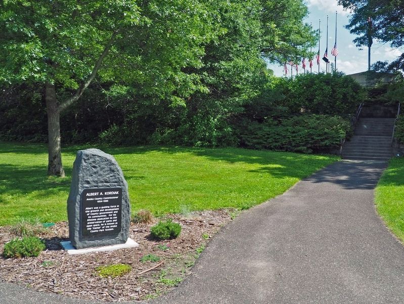
Near County Parkway C south of County Parkway B, on the left when traveling south.
Albert was a guiding force in the growth and development of County government and its communities. For his lifetime dedication to the preservation of parks and open space, he is known as the "Father" of the Anoka County Park System. — — Map (db m279218) HM
Constructed in 1986 for the citizens of Anoka County by authorization of the Anoka County Board of Commissioners
County Commissioners
Albert A. Kordiak • Natalie Haas Steffen • Dan Erhart • Robert Burman • Paul McCarron • Margaret . . . — — Map (db m280514) WM
The M41 Walker Bulldog was placed into service in 1953 during the Korean War. The tank, named for Army General Walton Walker, was an agile and well armed vehicle. However, due to its weight, fuel consumption and loud engine noise the tank saw . . . — — Map (db m282186) HM
The highest US military decoration, awarded by Congress to a member of the armed forces for gallantry and bravery in combat at the risk of life above and beyond the call of duty.
James Dennis LaBelle
Private First Class . . . — — Map (db m281431) HM WM
On West Main Street at Park Street, on the right when traveling east on West Main Street.
Dedicated to Aaron Greenwald and his comrades, who near this spot shortly after 10 A.M. on April 15, 1861, were the first Union Civil War Volunteers in the Nation.
Aaron Greenwald was killed at Gettysburg July 2, 1863, in the "Famous Charge That . . . — — Map (db m156730) HM WM
Near 2nd Avenue south of Adams Street, on the right when traveling south.
Anoka's first City Hall stood on Main Street between Second and Third Avenues and housed the fire department on the first level. Courtesy of the Anoka County Historical Society.
Starting in the 1950's, a series of annexations . . . — — Map (db m249568) HM
On the Rum River Regional Trail north of Harrison Street, on the left when traveling north.
The feed mill in the early 1950s had only two silos.
Owners Ernest Petersen and his sister, Alice, in the office, 1952 or 1953.
Anoka Independent Feed and Grain is one of Anoka's oldest family run businesses. . . . — — Map (db m248924) HM
Near 2nd Avenue south of Adams Street, on the right when traveling south.
Logging on the Rum River stretched from Mille Lacs to Anoka. This crew included J.W. Freeburg in 1894. Courtesy of the Anoka County Historical Society.
The last log drive on the Rum River occurred in the 1890's when the . . . — — Map (db m249652) HM
On E. Main Street at S. 3rd Avenue, on the right when traveling east on E. Main Street.
This building was designed by U.S. Government architect James Knox Taylor. It is a textbook example of Georgian Revival style architecture with its massive rectangular size, brick façade, cornice, arched windows, modillions under the eaves, and . . . — — Map (db m132571) HM
On 2nd Avenue north of Van Buren Street, on the left when traveling north.
Medal of Honor
Awarded to
Richard Keith Sorenson
Rank and Organization: Private US Marine Corps Reserve, 4th Marine Division
Place and Date: Namur Island, Kwajalein Attol [sic], Marshall Islands, 1-2 February 1944
Entered . . . — — Map (db m249068) WM
On Ferry Street (U.S. 169), on the right when traveling north.
Before this bridge was built, crossing the Mississippi River meant using either ice bridges or a ferry boat. The first ferry crossed the river at this point in the fall of 1855.
The first bridge to span the river between Anoka and Champlin . . . — — Map (db m288140) HM
Near South Ferry Road 0.3 miles east of South Ferry Street (U.S. 169).
The Mississippi River was an obstacle to overland travelers attempting to cross to the other side. From 1855 to 1884 a flat bottomed cable ferry was maintained between Anoka and Champlin. For a time two ferry companies operated at this . . . — — Map (db m158388) HM
Near South Ferry Road 0.3 miles east of South Ferry Street (U.S. 169).
The Dakota and Ojibwa people believed that the confluence of two great rivers was a sacred place.
The Point was used as an encampment and gathering place for several tribes. It was also a meeting place to form hunting parties going north . . . — — Map (db m70897) HM
On 3rd Avenue at Monroe Street, on the right when traveling north on 3rd Avenue.
Colonial Hall is a Georgian Revival style building that was designed as a home and medical-practice office for Doctors Alanson and Flora Aldrich. They were renowned for their civic engagement and medical practice. Dr. Flora Aldrich was one of . . . — — Map (db m286329) HM
On 1st Avenue at East Main Street, on the right when traveling south on 1st Avenue.
Father Louis Hennepin, Belgian Recollect missionary accompanying Sieur de la Salle's expedition to the Mississippi River region, left Fort Crevecoeur, Illinois, on February 29, 1680, for an exploration of the upper Mississippi River. On April 11, he . . . — — Map (db m225175) HM
Near South Ferry Road 0.3 miles east of South Ferry Street (U.S. 169).
Fireman's Grove is located here in the area just above the confluence of the Rum River. It was named for the firemen who pastured their horses at The Point. Fireman's Grove became a favorite gathering place for townspeople and visitors who . . . — — Map (db m70973) HM
On 2nd Avenue south of Harrison Street, on the right when traveling south.
In the early 1900s, brothers, J.W. (Bill) and Archie Freeburg were business partners in the W.H. LaPlant Company that sold feed, seed, coal and other farm related items. In 1933 Bill and Archie left the LaPlant Company and opened their own . . . — — Map (db m249021) HM
Map from the book, The Red River Trails by Gilman, Gilman, and Stultz. Minnesota Historical Society Pres, 1979.
Transportation is the key to the development of any community. The Rum and Mississippi Rivers were the . . . — — Map (db m249485) HM
Near South Ferry Road 0.3 miles east of South Ferry Street (U.S. 169).
The Rum and the Mississippi were highways for the earliest recorded European explorers of Minnesota. Many explorers traveled past The Point and some may have camped here including Radission, Hennepin, Du Luth, Pike, Faribault and Nicollet.
. . . — — Map (db m70569) HM
On W. Main Street at Green Avenue, on the right when traveling west on W. Main Street.
The first burial in Oakwood Cemetery was Alexander Lane on December 19, 1855. His grave is not the oldest grave here as his body was removed. The oldest grave in Oakwood Cemetery is that of Laura E. Little. She died in 1857 at age 22.
In . . . — — Map (db m283595) HM
On Jackson Street east of 2nd Avenue, on the right when traveling east.
The Jackson Hotel building stands at the heart of Anoka's business district and was a vital part of the prominent role Anoka played in Minnesota as a lumbering, agricultural, milling, and commercial trade center. The Jackson Hotel once featured . . . — — Map (db m308869) HM
On S. Ferry Road east of Ferry Street (U.S. 169), on the left when traveling south.
Built on one of Anoka's busiest thoroughfares, this French Second Empire style structure is of an impressive size, design, and prominent location, all of which were combined to make it unique. The building was Anoka's first hospital and played . . . — — Map (db m287611) HM
On the Rum River Regional Trail north of E. Main Street, on the left when traveling north.
Lincoln Mill, built in 1880 by W.D. Washburn, was the largest and most successful of Anoka's mills. The mill measured 60'x120' and was 7 stories tall. The mill was powered by two American turbine wheels, a 250-horsepower Corliss engine, and . . . — — Map (db m249327) HM
Near 2nd Avenue north of Van Buren Street, on the left when traveling north.
Logs were cut in the winter and stacked on the riverbank until they could be floated down river in the spring. Many rivers carried logs from more than one logging camp, so it was important to know which logs came from which camps. Before . . . — — Map (db m248813) HM
Near South Ferry Road 0.3 miles east of South Ferry Street (U.S. 169).
The white pine forests fell to the logger's ax in the northern Rum River pineries, "Seventy mills in seventy years could not exhaust the white pine I have seen on the Rum River" predicted Daniel Stanchfield, a lumber-wise timber cruiser . . . — — Map (db m70937) HM
On the Rum River Regional Trail north of E. Main Street, on the left when traveling north.
The first Main Street Bridge was built by Orin W. Rice as part of the Military Road project in 1853. The 140-foot wooden, single arch bridge served Anoka for more than 50 years. Around 1907, the wooden bridge was replaced with an iron . . . — — Map (db m249407) HM
Struggles and hardship are expected in building a community, but Anoka may have had more than its share of disasters. Through each trial, the community rebounded and Anoka continues to be a vital, dynamic community.
Anoka County was . . . — — Map (db m70953) HM
On Rice Street at Levee Avenue, on the left when traveling west on Rice Street.
The first ever swimming hole in the city of Anoka was known as Rice Street Beach. The beach was located at the west end of Rice Street and Levee Street on the Mississippi River. The beach first opened in 1931. The beach offered a recreational . . . — — Map (db m287155) HM
Near South Ferry Road 0.3 miles east of South Ferry Street (U.S. 169).
The Rum and the Mississippi were river highways for the Dakota, the Ojibwa, European explorers, traders and settlers.
Between 1850 and 1870 the Rum and the Mississippi became "working rivers" for lumbermen. In the fall loggers traveled . . . — — Map (db m70914) HM
Robert W. Akin (1871-1920) came to Anoka in 1898 and began working as a cashier in the State Bank. His property a few blocks south of Main Street on the east bank of the Rum River was said to be one of the "most picturesque sites in the . . . — — Map (db m162173) HM
Near North 2nd Avenue north of Jackson Street, on the left when traveling north.
The first dam was built here in 1853 of logs and earth fill by Caleb and W.H. Woodbury. It washed away in high water in the Spring of 1854. A second dam was built in 1854 by James McCann. This dam and its pool provided 5 sluiceways for water . . . — — Map (db m70264) HM
On the Rum River Regional Trail north of E. Main Street, on the left when traveling north.
Construction on the first dam began in late summer 1853. The dam was built using rocks, earth, and tamarack logs for pilings, which were cut from the swamps near Round Lake in Andover, MN. The dam was used to divert water to power the saw . . . — — Map (db m249175) HM
Near 2nd Avenue south of Adams Street, on the right when traveling south.
Oral traditions and archaeological evidence suggest early human habitation. Inhabitants hunted game, gathered plants, and made pottery. Conflict between the Dakota, who lived near Lake Mille Lacs, and the Anishinaabeg (Ojibwe) who were moving . . . — — Map (db m249680) HM
On Fremont Street at Franklin Lane, on the left when traveling west on Fremont Street.
The Greek Revival Architecture and its association with the founding of Anoka combine to make this property historically significant. The original east section of the house was built for Neil Shaw and his family, who were prominent land . . . — — Map (db m285801) HM
The square of land on the east side of the Rum River just south of Main Street has been a place for Anoka citizens to gather since the town began in the mid-1800's. Known as Bridge Square, it was a place to share news, to hear speeches and . . . — — Map (db m70586) HM
Peninsula Point is formed by the confluence of two great rivers. Throughout its history it has been the meeting place of many cultures. Now Peninsula Point Two Rivers Historical Park, "The Point," is a meeting place for you to discover the rich . . . — — Map (db m248604) HM
Near 1st Avenue south of East Main Street, on the right when traveling south.
Three stone houses were built during the 1920's by Thaddeus P. Giddings (1969-1954). Giddings was the Supervisor of Music for the Minneapolis Schools and founder of the National Music Camp in Interlachen, Michigan. The stone houses were part . . . — — Map (db m70825) HM
On Jefferson Street west of 3rd Avenue, on the right when traveling east.
This house was the home of three generations of the Ticknor Family, who greatly contributed to the development of Anoka. The architecture of the house incorporates design features of Gothic Revival (1867, design of original house) and the Queen Anne . . . — — Map (db m181514) HM
Near S. Ferry Road east of Ferry Street (U.S. 169).
100-year chronology of significant events affecting water quality in Anoka and the Mississippi River
c. 1900
Residential sewage flowed directly to the river without treatment.
1916
Anoka's first rudimentary wastewater . . . — — Map (db m288652) HM
On 2nd Avenue south of Harrison Street, on the right when traveling south.
Built in 1872 by W.D. Washburn & Co., the mill had an annual production of 16 million board feet of lumber. Combined with the planing mills, dry kilns, etc., the mill employed about 125 men. For 17 years logs from the headwaters of the Rum . . . — — Map (db m242327) HM
On Harrison Street at 2nd Avenue, on the right when traveling west on Harrison Street.
Washburn Saw Mill Chimney
On July 13, 1907, in front of a crowd of 3,000 onlookers, the iconic 90-foot Washburn Saw Mill chimney was razed. The chimney was constructed of approximately 125,000 Kelsey bricks; a high-quality . . . — — Map (db m248997) HM
Near South Ferry Road 0.3 miles east of South Ferry Street.
Native peoples and traders met at a trading post constructed across the Rum River from The Point in 1844 by Joseph Bellanger. The Ojibwa brought furs and skins to trade for copper cooking pots, cloth, blankets, decorative beads and iron . . . — — Map (db m70921) HM
Near South Ferry Road 0.3 miles east of South Ferry Street (U.S. 169).
The Mississippi River forms a unique and complex ecosystem spanning 2000 miles. From its origin at Lake Itasca in Northern Minnesota to its outlet in the Gulf of Mexico the river encompasses a diversity of life found only in a very few places . . . — — Map (db m70908) HM
Who Lived Here
Thousands of years ago, glaciers and inland seas covered much of North America. These early forces shaped the land to form lakes, rives, soil deposits, and land features. Sandy soil at the southern end of the Rum River . . . — — Map (db m236855) HM
Why Settle Here? Looking for Work
Timber was a resource that drew many west and in 1847, surveyor Daniel Stanchfield noted, "Seventy mills in seventy years couldn't exhaust the white pine I have seen on the Rum River". The rivers . . . — — Map (db m70982) HM
On Castle Field Boulevard west of 7th Avenue, on the left when traveling west.
Willard "Butch" Castle, was a lifelong resident of Anoka, Marine Corps Corporal, Veteran of World War II, and an outstanding athlete. He received All-Region and All-District honors in basketball while attending Anoka High School and was a . . . — — Map (db m279129) HM
On Ferry Street at the footbridge over the Rum River, on the right when traveling north on Ferry Street.
This amphitheater is a rare example of a semi-circular, open-air theater in Minnesota. It echoes the design of ancient Greek and Roman theaters. Set into the hillside, it was designed to accommodate 1,600 people. The idea for its construction . . . — — Map (db m230699) HM
Near Egret Boulevard NW, on the right when traveling south.
Coon Rapids Dam pictured above during construction in 1913. Near here, a small village sprang up during construction of the Coon Rapids Dam. At peak construction, the site became a community including bunkhouses, mess halls, official's quarters, . . . — — Map (db m279236) HM
The Mighty Mississippi River One of the world’s great rivers, the Mississippi trickles from Minnesota’s Lake Itasca, gathering the waters of the nation’s heartland as it flows to the Gulf of Mexico. On its timeless journey, the river weaves . . . — — Map (db m70952) HM
The gates of the Coon Rapids Dam have changed throughout the years to keep up with flow of the Mississippi River. The Coon Rapids Dam was built in 1913 to generate electric power for a proposed trolley line. The metal structure you see before . . . — — Map (db m280036) HM
Over 600 men worked around the clock using hand tools, horses and coal powered shovels to build the original dam in 1913.
From 1914 until 1966 the dam produced electricity using the energy of falling water. The water fell 19 feet to turn . . . — — Map (db m280346) HM
On E. River Road at Rice Creek Way NE, on the left when traveling north on E. River Road.
On the 12th of April 1870, Manomin County was admitted to Anoka County. At that time the name was changed to Manomin Township and later to Fridley Township. This Anoka County Park was formally dedicated 'Manomin' on the 6th of February 1973 by . . . — — Map (db m282372) HM
Near E. River Road at Rice Creek Way NE, on the left when traveling north.
[obverse]
The Banfill-Locke Tavern stands at the confluence of Rice Creek and the Mississippi River. This two story, Greek Revival style building was built in 1847. John Banfill, a retired Colonel and the state's first Auditor, used it as an . . . — — Map (db m282246) HM
On W. Moore Lake Drive at 61st Avenue NE, on the right when traveling south on W. Moore Lake Drive.
1938
In 1938, Moore Lake was surrounded by farms and forests and very few people. Despite the lack of modern development, Moore Lake still had its problems. Runoff from agricultural fields carrying sediment and nutrients appears to . . . — — Map (db m248397) HM
On W. Moore Lake Drive at 61st Avenue NE, on the right when traveling south on W. Moore Lake Drive.
What are Native Plants?
Plants found in Minnesota before extensive European settlement in 1850 are considered native to the state. These plant species are well-adapted to Minnesota's soil conditions and seasonal changes in . . . — — Map (db m248321) HM
On E. River Road at 51st Way N.E., on the right when traveling south on E. River Road.
1880 – Albin Riedel immigrated from Germany to New York City. He accepted a job offer to work on a farm in Minnesota. After earning enough money, he purchased land in Fridley and built this large farmhouse.
1889 – Swedish immigrant, . . . — — Map (db m248740) HM
On Swedish Drive NE, on the right when traveling east.
This church, the Swedish Evangelical Lutheran Church of Ham Lake as it is called on the National Register of Historic Places, has a rich history. Founded in 1872, the building was constructed on land donated by Johan and Fredrika Magnuson shortly . . . — — Map (db m207320) HM
On U.S. 10 0.8 miles east of Cleveland Street, on the right when traveling east.
Twenty thousand years ago, a great sheet of ice, the Superior lobe, covered this
area. At its farthest advance, it formed the St. Croix moraine, a series of high hills to the
west, south, and east. When it melted, it left behind vast . . . — — Map (db m70297) HM
On U.S. 10 0.8 miles east of Cleveland Street, on the right when traveling east.
Itasca grew up around an Indian trading post which was established 800 feet east of here in 1849 by Thomas A. Holmes and James Beatty. At the suggestion of Territorial Governor Alexander Ramsey, the settlement was named in honor of Lake Itasca, the . . . — — Map (db m69908) HM
On Riverdale Drive NW west of Ramsey Boulevard NW, on the right when traveling west.
The Mississippi National River and Recreation Area is a 72-mile river park that has opportunities for fishing, boating, and canoeing. On its banks are excellent locations for birding, bicycling, and hiking. Although annually millions of . . . — — Map (db m278724) HM
On Rum River Blvd NW at Bridge St NW (County Road 24), on the right when traveling north on Rum River Blvd NW.
The Rum River, a 148 mile river of gradual grade, is rich in history. The French explored it. The Chippewa and Sioux fought along it, and the pine logs that helped build the cities of the Midwest were floated down it during the lumber boom of the . . . — — Map (db m94721) HM
On Main Street East east of Broadway Street, on the right when traveling east.
Carver Historic District
has been placed on the
National Register
of Historic Places
by the United States
Department of the Interior
Church by-the River,
Presbyterian Church
1913 — — Map (db m79234) HM
On Broadway Street North at 4th Street East, on the right when traveling north on Broadway Street North.
Carver Historic District
has been placed on the
National Register
of Historic Places
by the United States
Department of the Interior
Funk Hardware Store
ca. 1880 — — Map (db m79278) HM
On Broadway Street (County Highway 40) at Main Street West (County Highway 40), on the right when traveling south on Broadway Street.
Carver Historic District
has been placed on the
National Register
of Historic Places
by the United States
Department of the Interior
Minnesota Valley Oil Co.
1925 — — Map (db m75255) HM
On Broadway Street at Main Street West (County Highway 40), on the right when traveling south on Broadway Street.
Carver Historic District
has been placed on the
National Register
of Historic Places
by the United States
Department of the Interior
Stephen Kult Clothing Store
1871 — — Map (db m79125) HM
On Oak Street North north of 4th Street East (County Highway 40), on the right when traveling north.
Carver Historic District
has been placed on the
National Register
of Historic Places
by the United States
Department of the Interior
Trinity Lutheran Church
1914 — — Map (db m79158) HM
On West 4th Street west of North Chestnut Street (Minnesota Highway 41), on the right when traveling west.
This property
has been placed on the
National Register
of Historic Places
by the United States
Department of the Interior
Brinkhaus Livery Stable
1890 — — Map (db m59555) HM
On North Walnut Street south of East 4th Street, on the right when traveling south.
City Square Park
City Square in Chaska has always been a gathering place and the heart of this community. The land was set aside for public purpose in 1852 in the original plat. Early settlers in Chaska found six earthen mounds on this . . . — — Map (db m63707) HM
On North Chestnut Street (State Highway 41) at Hundertmark Road, on the left when traveling north on North Chestnut Street.
This silo marks the site of the Christian Bender farm, homesteaded in 1854. George Bender, grandson of Christian, sold the farm to Henry McKnight in 1963. This was the first farm to become part of Jonathan.
Dedicated . . . — — Map (db m60394) HM
On Chaska Boulevard (County Highway 61) 0.3 miles west of North Hickory Street (County Road 140), on the right when traveling west.
By 1804 Jean B. Faribault was trading in furs for the Northwest Company near the "Little Rapids" of the Minnesota River, 5 miles south of this point, and in this vicinity. His fur post of 1824 on the site of Chaska became the nucleus for the first . . . — — Map (db m41051) HM
The first burial at this location was 1857.
There is no cemetery record of who or where people are buried in this location.
During the decade of 1960 vandals damaged monuments.
The damaged monuments were removed[.] In the process the . . . — — Map (db m311182) HM
Dedicated by the Luther League to the honor of the men from the East Union Evangelical Lutheran Church who took part in the World War 1914-1918.
George W. Lundquist •
Clarence A. Ekström •
Wilhard E. Olander •
Henry R. Nord •
J. Elmer A. . . . — — Map (db m94398) WM
On 1st St NW at County Highway 25, on the right when traveling east on 1st St NW.
James J. Hill
The Dakota Rail Regional Trail follows the route of a former railroad line that was once part of the Great Northern Railway. Built by James J. Hill in the late 1800s, this historic line played a part in connecting Minnesota to . . . — — Map (db m98390) HM
On Minnesota Veterans Memorial Highway (U.S. 212) at Tacoma Avenue, on the right when traveling east on Minnesota Veterans Memorial Highway.
Otto Oschner Jr • Army • WWI / KIA
Donald J Greene • Army • Vietnam KIA
Bill G Insall • Army • Vietnam KIA
Edward Born • Army • World War I KIA
Jerry E Auxier • Army • Vietnam KIA
Karsten H Panning • Army • Civil War / KIA
Wilmer H . . . — — Map (db m311229) WM
Near Grimm Road west of Victoria Drive (County Route 11), on the right when traveling west.
"The production of a forage plant so hardy as Grimm Alfalfa is almost without parallel in plant history... It is impossible to compute in dollars and cents what it has meant to the nation."
Everett Edwards, 1938
U.S. Department . . . — — Map (db m212539) HM
Near Grimm Road west of Victoria Drive (County Route 11), on the right when traveling west.
The Big Woods
When the first Euro-American settlers came to this area in the 1850s, the land looked very different than it does today. At that time, the spot where you now stand would have been near the center of a two-million-acre hardwood . . . — — Map (db m212415) HM
Near Grimm Road west of Victoria Drive (County Route 11), on the right when traveling west.
The Brick Farmhouse
The brick farmhouse before you was built by the Grimm family sometime around 1875. It replaced a small log cabin where the family had lived since they first acquired the property in 1857. More than just a new home, this . . . — — Map (db m212381) HM
On East 1st Street east of South Pine Street, on the left when traveling east.
To the Memory
of the
Defenders of the
Union,
1861 to 1865.
Erected by the Citizens
of
Carver County in 1892.
F. Anthony, S.M. Alexander, Ch. All, A. Arneson, L. Anderson, C.F. Anderson, S. Anderson, A.G. Anderson, J. Anderson, . . . — — Map (db m71715) WM
On Burandt Boulevard, on the left when traveling south.
There was a time, not long ago, that harvesting meant long hours of hard manual labor. The process of harvesting grain meant first cutting the grain with a cradle scythe. The stalks were then gathered by hand and tied into bundles. Groups of 15-20 . . . — — Map (db m163406) HM
Near East Main Street west of South Spruce Street, on the left when traveling west.
World War II
Poland -
Battle of the Atlantic -
Pearl Harbor -
Bataan -
Corregidor -
Coral Sea -
Midway -
Guadalcanal -
North Africa -
Bismarck Sea -
Salerno -
Tarawa -
Kwajalein -
Normandy -
Southern France -
The . . . — — Map (db m72282) WM
On East Main Street west of Spruce Street, on the left when traveling west.
Erected in Memory
of Those Who Served
During the World War
1914 —— 1918
Allmann Andrew •
Bade Ed. •
Bade Henry •
Beck Walter •
Beiersdorf O.H. •
Boettcher Otto •
Boehmke Herb •
Brandenburg Henry . . . — — Map (db m71520) WM
Near Mill Avenue Northeast 0.1 miles north of Carter Street Northeast, on the left when traveling north.
Watertown is one of the oldest settlements in Minnesota’s south central region. Chief Little Crow of the Dakota Nation and his tribe often camped by the Crow River. At first the Chief and the settlers trusted each . . . — — Map (db m213030) HM
On Lewis Avenue North just north of Territorial Street West, on the right when traveling north.
Minnie Christina Peterson Upon her father's death in 1914, Minnie became the sole proprietor of the Watertown General Merchandise Store. It's been said that Minnie was "way ahead of her time for a business woman." She passed away in a tragic . . . — — Map (db m213045) HM
On Mill Avenue Northeast just north of Carter Street Northeast, on the left when traveling north.
Kathryn M. Burns "There are no words that can ever begin to describe the depth and meaning of the years that Kitty helped serve multiple patients in the Watertown and Waconia area. Kitty was truly a gracious, caring, and loving unselfish . . . — — Map (db m213084) HM
On Lewis Avenue North 0.1 miles north of Territorial Street West, on the right when traveling north.
Civil War 100 Watertown pioneers served in the Union Army during the Civil War. They served in infantry, artillery, and cavalry regiments. By 1865 there was not a man left in the area between the ages of 18 and 45; the town remained at a . . . — — Map (db m213070) HM
On Park Trail (County Route 12) at Maple Lane, on the right when traveling north on Park Trail.
The village of Almelund and the Immanual Lutheran Church were established in 1887
Reverse
By Gods grace, the people of Amador Township and with the assistance of the Almelund Lions Club, this Triangle Park was developed in 1987. . . . — — Map (db m232288) HM
The pristine view in front of you would look much different without Walter F. Mondale's passion and tenacity. As Minnesota Attorney General, U.S. Senator, Vice President and an engaged citizen, he has spent a lifetime advocating for the . . . — — Map (db m235503) HM
Near the main park road north of the road to the boat landing, on the left when traveling north.
One seed at a time, human hands are reviving this rich prairie.
This area was named Amador Prairie in the 1850s. However, prairie species faded as crops were planted, farm animals grazed, and homes and schools were built.
Efforts to . . . — — Map (db m235618) HM
Off in the distance, near the river, is a stand of conifer trees. Can you find it? Conifers are trees that produce cones, such as pines, spruces, cedars, firs and tamaracks.
In this part of Minnesota, conifer forests often exist only in small . . . — — Map (db m231375) HM
[Panel 1]
View of Almelund, 1902.
Photographer: Seth Cedarholm
Relationships that began in the eastern United States sometimes resulted in two or more families settling together when they reached Minnesota. An example . . . — — Map (db m235615) HM
Logs collected above the dam until they were needed at sawmills downriver.
Photo courtesy of St. Croix National Scenic Riverway (National Park Service)
The Last Log Drive
Large numbers of logs were sluiced . . . — — Map (db m235036) HM
People Of The ValleyWe have evidence of many earlier users of the St. Croix River Valley. Why do you think they decided to come here?
People look for ways to make their lives better. Many people found what they needed along . . . — — Map (db m233090) HM
[First panel]
Farmers hauling milk into Almelund, ca. 1902.
Photographer: Seth Cedarholm.
The Military Road ran from Point Douglas in Hastings, Minnesota to Superior, Wisconsin.
Above: Superior, . . . — — Map (db m233093) HM
1139 entries matched your criteria. The first 100 are listed above. Next 100 ⊳