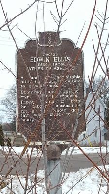
On Stuntz Avenue at 3rd Street East, on the right when traveling south on Stuntz Avenue.
A man of indomitable faith, he brought culture to a wilderness.
Learning and religion were of first concern. Freely giving to both, he labored unceasingly for a city whose good lay very close to his heart. — — Map (db m94062) HM
On Lake Shore Drive East (U.S. 2) 0.1 miles west of 20th Avenue East, on the right when traveling west.
William Daniel Leahy was born in Iowa in 1875 and his family soon moved to Wisconsin. He graduated from Ashland High School in 1892 and for the rest of his life considered Ashland his home town.
Leahy graduated from the Naval Academy and served . . . — — Map (db m204096) HM
On Ellis Avenue (State Highway 13) north of 16th Street east, on the right when traveling north.
North Wisconsin Academy, founded in 1892 by the Congregational Churches, provided the first high school education available to young people of the small, isolated lumber camp, sawmill and farm communities in the area known as the Great Lakes Pinery, . . . — — Map (db m209668) HM
On Lake Shore Drive West (U.S. 2) at Turner Road, on the right when traveling west on Lake Shore Drive West.
A crude structure of boughs of trees “layed acrosse, one upon an other” was erected near here by Pierre Radisson and Medart Groseilliers in 1659. The two French traders came to Chequamegon Bay from Montreal and Radisson's account of . . . — — Map (db m48410) HM
On Main Street West east of 3rd Avenue West, on the right when traveling east.
This property has been placed on the
National Register of Historic Places
by the United States Department of the Interior
Security Savings Bank 1889 — — Map (db m125034) HM
On Depot Drive at 3rd Avenue West, on the left when traveling north on Depot Drive.
When built in July 1900 by the Baldwin Locomotive Works of Philadelphia, engine 950 was the world's largest steam locomotive at a weight of 190,000 pounds with a tractive effort of 47,090 pounds. Originally numbered 600 by the Soo Line, it . . . — — Map (db m272586) HM
On East First Street (County Highway N) east of North Grant Street, on the left when traveling east.
Glidden State Bank
Circa 1905
has been placed on the
National Register
of Historic Places
by the United States
Department of the Interior
Nominated by
Jerry Hellenbrand - 2006 — — Map (db m47483) HM
On State Highway 13 2 miles north of State Highway 77, on the left when traveling north.
You are now on the great divide which separates the two principal drainage areas of Wisconsin. Water falling to the north of this point finds its way into Lake Superior, then down through the Great Lakes and the St. Lawrence River 2,000 miles into . . . — — Map (db m47222) HM
On East First Street (County Highway N) at North Grant Street on East First Street.
This white pine log was sleigh hauled to Glidden on Dec. 21, 1984 on the sleigh it sets on. It was cut on State 40 14 miles east of Glidden. Its estimated weight is 7000 lbs. The 20 ft log scaled 1960 [?] board ft. Estimated age 500 to 600 . . . — — Map (db m47534) HM
On Fort Road 0.5 miles south of Ferry Dock, on the right when traveling south.
Native American canoes launched North America’s maritime legacy about 12,000 years ago, making them among the world’s oldest watercraft.
The origins of the birchbark canoe are told in the oral traditions of the Ojibwe people. The spirit . . . — — Map (db m57836) HM
Early Native American Inhabitants
People have been using and occupying sites in the Apostle Islands area for thousands of years. But it was probably not until after 800 A.D. that more extensive use of the islands took place in the form of . . . — — Map (db m165677) HM
On Chief Buffalo Lane west of Old Fort Road, on the left when traveling north.
Established about 1836 as part of a Roman Catholic mission under the guidance of the dynamic Austrian priest, Frederick Baraga, later made a bishop.
The white man's style of house was adopted as a grave cover by the Christianized Ojibway . . . — — Map (db m144130) HM
On Bayfield - La Pointe Avenue at Colonel Woods Avenue (County Route H), on the left when traveling north on Bayfield - La Pointe Avenue. Reported permanently removed.
The largest of the Apostle Islands was one of the earliest areas of Indian settlement, fur trade, missionary activity and commercial fishing in the interior of North America. It was discovered by French explorers in 1659. Trading posts were built . . . — — Map (db m234580) HM
On Old Fort Road north of Capser Road, on the right when traveling south.
A French-Canadian trader built a post on this site about 1792. From his wife Madeline daughter of the Chippewa chief White Crane the island takes its present name.
The official French fort La Pointe was built in 1718 about 500 feet west. Its . . . — — Map (db m144128) HM
Aaniin, visitors. Welcome to Mooningwaanikaaning, the homeland of the Ojibwe people. The Ojibwe name for Madeline Island means “home of the yellow-breasted flicker bird.” This island was the last-foretold stopping point on the Ojibwe migration . . . — — Map (db m234361) HM
On the Lagoon Ridges Trail, on the right when traveling north.
This blow down area is a result of a wind storm to the island on June 27 1991. Winds were in excess of 100 mph. Damage to the island was spotty ranging from little to very intensive impact. — — Map (db m255116) HM
This willow tree began as a spring from a tree taken from the grounds of the birth place of Jeanne D'Arc of Dormery, Haute Marne, France. In May 1919, sprigs of this willow we're sent a number of Americans Legion Posts by the University of . . . — — Map (db m201014) HM
Near POW/MIA Memorial Highway (State Highway 13) at Fayette Avenue, on the right when traveling north.
Mellen, Wisconsin, nestled in a valley in the heart of the Penokee Range, was founded in 1881 by Samuel O'Grady Bennett for which Bennett Street is named.
Iron City, later renamed Mellen for William Mellen of the Wisconsin Central Railroad was . . . — — Map (db m201380) HM
Near POW/MIA Memorial Highway (State Highway 13) at Fayette Avenue, on the right when traveling north.
In honor of those who served.
In memory of: James Ledin and Melvin Gunderson, who gave the supreme sacrifice. This tree was planted, by Vietnam Veterans, on November 10, 2007, — — Map (db m201381) HM WM
On U.S. 2 at Old Odanah Road, on the left when traveling west on U.S. 2. Reported permanently removed.
The Mauvaise (Bad) River was so named by the French due to the difficulties of its navigation. The Indians called it Mushkeezeebi or Marsh River. In 1845 the Rev. L.H. Wheeler, Protestant missionary at La Pointe, planned an agricultural settlement . . . — — Map (db m63661) HM
You might know that Lake Superior is the largest body of freshwater in the world, but did you know that it is large enough to generate its own small tide?
This tidal action, called "seiche,” influences Fish Creek. At times, water from Chequamegon . . . — — Map (db m201391) HM
Near Major Richard I. Bong/POW-MIA Memorial Highway (U.S. 2) 1 mile west of Turner Road.
VOICES IN THE MIST
When the mist turns a waltz along the shoreline, and swirls heavenward via convection, lend your ears to the bay. There are forms in the mist, and in the forms there are faces. The faces smile, and the hint of a melody plays . . . — — Map (db m201384) HM
"Bayfield is settling down to its regular winter's business... cord wood, pine logs, oak timber, steamboat wood and fish are the staple products, and the supply is unlimited."
- Bayfield County Press, November 28, 1877 Changing . . . — — Map (db m258915) HM
The Hokensons at Little Sand Bay were just one of many commercial fishing families in the area. This pound net boat came from Rocky Island where a community of fish camps was established in the 1930s. The Olsen, Erickson, Benson, Edwards, Hadland, . . . — — Map (db m258911) HM
On South 1st Street at Wilson Street, on the left when traveling south on South 1st Street.
You are standing at the “turning Point” for the Bayfield Waterfront Walk and across the water is a place of significance where “turning points” in history occurred. Madeline Island, or “Mooningwanekaaning Minis,” . . . — — Map (db m98243) HM
On Washington Avenue at North Front Street, on the left when traveling east on Washington Avenue.
Bayfield’s history has been powerfully shaped by its location. Situated on the shores of a deep, natural harbor, the city is sheltered from Lake Superior’s notorious storms by the outlying Apostle Islands. Lighthouses, shipwrecks, and a historic . . . — — Map (db m57835) HM
"The planting of millions of fish, with regulations governing the size, limiting the number to be taken each day, and the season that they may be taken from our waters will make it possible to maintain the fish supply for all time to come." . . . — — Map (db m258926) HM
"This is the best combination of cultural heritage and land management that I can think of."
Bob Krumenaker, Superintendent
In October 2017, Apostle Islands National Lakeshore, in collaboration with the Red Cliff Band, Bad River Band . . . — — Map (db m201395) HM
"One could gather biographies of senior citizens around Lake Superior and find that nearly every individual engaged in multiple occupations in order to survive."
- Family Managed Commercial Fishing in the Apostle Islands, NPS Special . . . — — Map (db m258924) HM
On Front Street north of Rittenhouse Avenue, on the right when traveling north.
Dedicated in 1981 to the hard working commercial fishermen whose indomitable spirits will not be forgotten.
Commissioned by Edwin Erickson,
Mayor of Bayfield, 1970-1976 & 1980-1988
Designed by Harold Kerr (1909-1981)
Constructed by . . . — — Map (db m57811) HM
Near South 1st Street north of Manypenny Avenue, on the right when traveling north.
Pleasure boating grew hand-in-hand with boat clubs of the 1880s and 1890s.
Regattas and other competitions fostered growth in small sailing craft on Lake Superior. The first sailing regatta at Bayfield in 1899 offered a $100 prize.
Serious . . . — — Map (db m260378) HM
On South 1st Street at Wilson Street, on the right when traveling south on South 1st Street.
Listed on the National Register of Historic Places
In the waters off Outer Island lies the wreck of the Pretoria, one of the largest wooden vessels ever to sail the Great lakes. On September 1, 1905, Captain Charles Smart and nine crew . . . — — Map (db m98244) HM
On Washington Avenue at Front Street, on the left when traveling east on Washington Avenue.
At one time, a local fishery once encompassed this entire block. Early sailing vessels would bring their harvests here to be salt packed in barrels and shipped to market. Here in “The Cooperage,” one of the remaining buildings of that . . . — — Map (db m57810) HM
On State Highway 13 west of Siskiwit Falls Road, on the left when traveling east.
Once upon a time, according to an old Indian legend, the sand beach on the east side of this bay was a favorite camping ground. One spring a few lodges of Chippewa from La Pointe encamped here. When their chief, Bi-aus-wah, returned from the hunt, . . . — — Map (db m194929) HM
On Lenawee Road 0.1 miles south of Wisconsin Highway 13, on the left when traveling south.
When the community sought funding for a new gymnasium and town hall, they looked to the Work Progress Administration, a depression-era program, which utilized local materials and labor to create jobs for unemployed workers. Architect Roland C. Buck . . . — — Map (db m36553) HM
On Ino Road (Forest Road 236) at 407, on the left when traveling north on Ino Road.
In 1935 the Forest Service set aside the one square mile (640 acres) to the North of this point as a “natural area.” This area is administered for ecological research purposes to obtain a better understanding of the natural processes governing the . . . — — Map (db m215839) HM
On State Highway 13, on the right when traveling west.
The familiar sandstone outcroppings along Lake Superior's shoreline provided a popular building material for grand and massive structures all over the Midwest and Eastern United States throughout the last half of the Nineteenth and into the . . . — — Map (db m201591) HM
On State Highway 13 at Grand Avenue, on the right when traveling west on State Highway 13.
As the 20th century began, logging operations were in full swing in this area and the small log schoolhouses could not handle the increasing number of students. Some classes were held in churches but additional facilities were needed.
T.N. . . . — — Map (db m30845) HM
Near Little Sand Bay Road west of Allen Road, on the right when traveling west.
Leo, Roy, and Eskel Hokenson began fishing commercially at Little Sand Bay in the 1920s. During the fall herring season, the brothers fished at night when cooler temperatures helped preserve the catch. Noting this habit, friends began saying, . . . — — Map (db m258909) HM
On Little Sand Bay Road 0.5 miles west of Allen Road.
Harvesting the Waters
In 1927, the Hokenson brothers (Leo, Roy, and Eskel) began life as fishermen. For more than 30 years, they met the challenges of fishing the largest lake in the world, relying on their skills, strength, and . . . — — Map (db m46908) HM
Near Little Sand Bay Road 0.5 miles west of Allen Road.
Type: Steel, bulk and package freighter
Built: 1890, Frank W. Wheeler, Bay City, Mich.
Sank: September 2, 1905
Length: 372’ Beam: 41’
Cargo: Iron ore
Propulsion: Propeller
Depth of Wreckage: 25’
Lives Lost: 7
Listed on the . . . — — Map (db m46907) HM
On East Bayfield Street (State Highway 13) at Central Avenue, on the right when traveling south on East Bayfield Street.
The Bank of Washburn is a unique variation of the Romanesque Revival Style designed by architects Conover & Porter of Ashland, Wisconsin. Built in less than one year, the building was fashioned from brownstone quarried at Houghton Point located . . . — — Map (db m48439) HM
On State Highway 13 north of Burlager/Bodin Road, on the right when traveling north.
To the east is Madeline Island, known to the Ojibway as Moning-wunakauning, “The Home of the Golden Breasted Woodpecker.” The French soldier Pierre le Sueur built his post there in 1693. In 1718 a fort was erected which remained France’s principal . . . — — Map (db m208926) HM
The Sprague Well, believed to be the first drilled artesian well in Bayfield County, was completed at 119 feet 8 inches in April, 1903 by Monroe H. Sprague at the mill office of the Akeley–Sprague Lumber Co. Flow from the 4 inch casing was . . . — — Map (db m57812) HM
Near 6th Avenue West south of Lakeview Drive, on the left when traveling south.
In the early days of Washburn, the waterfront was filled with saw mills. The A.A. Bigelow Mill (1887-1902), later to become the Hines Mill, was the largest of three major sawmills in Washburn. It rested on pilings that ran directly out from the . . . — — Map (db m122317) HM
Near 6th Avenue West south of Lakeview Drive, on the left when traveling south.
(side 1)
Washburn Lumbering Days
Washburn begins on the shoreline of Chequamegon Bay. The city rises gradually 75 ft. above level of the water. In 1884, the town was created, born of the necessity of the railway (Chicago, St. Paul, . . . — — Map (db m57824) HM
On East Bayfield Street (State Highway 13) at Central Avenue, on the right when traveling south on East Bayfield Street.
This title was given back in 1892 when Frederick Prentice, president of the Prentice Brownstone Co. of Wisconsin, offered to supply a huge brownstone monolith for the Wisconsin Exhibit at the 1893 World’s Fair in Chicago. He proposed to furnish this . . . — — Map (db m48441) HM
On U.S. 2 at Ranger Road, on the right when traveling east on U.S. 2.
The Brule River flows in the former channel of a larger river which once flowed in the opposite direction and drained melting ice from glacial lake Duluth. The receding glacier created Lake Superior and also carved the valley now occupied by the . . . — — Map (db m58502) HM
Near U.S. 2 at Ranger Road, on the left when traveling west.
In June and July 1680
Daniel Greysolon Sieur Dulhut
“Gentleman of the King’s Guard”
Soldier, Explorer, Trader, and Governor
accompanied by four Frenchmen
LaMaitre, Bellegrade, Masson, and Pepin,
passed up the Brule River, . . . — — Map (db m58504) HM
On County Road Y at Antoine Circle, on the left when traveling east on County Road Y.
Antoine and Sarah Gordon settled here in 1858, establishing a home and businesses that would contribute to the founding of the town of Gordon. The Gordons built a cabin and trading post along the Trail to La Pointe, an overland path of Native origin . . . — — Map (db m276407) HM
Near Packer Avenue north of Spruce Drive, on the right when traveling north.
In September 1860, Antoine Gordon arrived from Madeline Island and established a trading post at the junction of the St. Croix and Eau Claire rivers. This land had long been the summer home of the Chippewa Indians who used the Brule-St. Croix . . . — — Map (db m43698) HM
On County Route B at County Route F, on the right when traveling west on County Route B.
Here, in 1903, Dr. W.B. Hopkins, Cumberland, opened the first tuberculosis sanatorium in Wisconsin. He built an office and three one-story frame buildings with screen sides – the men’s ward, the women’s ward and a dining hall.
Hopkins . . . — — Map (db m72193) HM
On Main Street east of County Highway D, on the left when traveling east.
It was here that Major Richard I. Bong was born, received his education, and grew to manhood. After attending Superior State College where he received his first pilot training, he joined the U.S. Army Air Corps on May 29, 1941. Assigned to the New . . . — — Map (db m72259) HM
On Memorial Drive east of South Village Road, on the left when traveling east.
This Lockheed P-38 Lightning fighter, through the efforts of General George C. Kenney, was donated by the United States Air Force in memory of Major Richard I. Bong. Major Bong a native of Poplar, was credited with destroying 40 Japanese aircraft in . . . — — Map (db m43433) HM
Approximately one mile northeast of this point, a continental divide separates the watersheds of the Brule and St. Croix Rivers. The Brule flows north to Lake Superior and the St. Croix flows southerly to the Mississippi. A time worn trail . . . — — Map (db m23482) HM
Near Business U.S. 53 0.2 miles north of U.S. 53, on the right when traveling north.
The Brule and St. Croix rivers provide the natural water highway between Lake Superior and the Upper Mississippi. Daniel Greysolon, Sieur du Lhut, in 1680 was the first white man to use this passage.
Traveling from Prairie du Chien in 1766, . . . — — Map (db m43476) HM
On County Road A 0.2 miles south of County Road P, on the right when traveling north.
Upper Lake St. Croix end of trail,
discovered 1680.
Indians, voyageurs, explorers,
missionaries, traders and pioneers travelled
this path from the waters of the
Great Lakes to those of the Mississippi.
To all who pass this way . . . — — Map (db m58505) HM
Near State Highway 13 at Old Highway 13, on the right when traveling east.
Built by Finnish immigrant and homesteader, Jacob (Tapola) Davidson, it served Old-Brule and Lakeside in the South Shore region from 1904 to 1926. Constructed of native materials, it was used for milling locally grown grains for both animal and . . . — — Map (db m76206) HM
On East 1st Street 0.2 miles west of 37th Avenue East, on the right when traveling west. Reported permanently removed.
These docks, the largest in the world, consist of three structures of concrete and steel. The longest dock is 2244 feet long, 80 feet high, and contains 374 individual pockets which can hold 100,000 long tons of ore, or 7 average trains of 205 . . . — — Map (db m285058) HM
Developed by U.S. Army Corps of Engineers, St. Paul Lake Superior Area in Cooperation with Cities of Superior and Duluth
Since 1861 when Captain George G. Meade (later, the victorious General at the Battle of Gettysburg) first surveyed the . . . — — Map (db m201061) HM
On Wisconsin Point Road 1.7 miles north of Moccasin Mike Road, on the right when traveling north.
"By the shores of Gitche Gumee,
By the shining Big-Sea-Water,"
Longfellow
Lake Superior - the largest body of fresh water in the world - almost chemically pure - mean . . . — — Map (db m47021) HM
Near East 2nd Street (U.S. 2 / 53) 0.4 miles east of 57th Avenue East (County Highway E), on the right when traveling east.
Over millions of years, the forces of nature have given Northwest Wisconsin some of the finest scenery in the world. The most striking feature is Lake Superior, largest freshwater lake in the world and the "Gitche Gumee" of Henry Wadsworth . . . — — Map (db m43390) HM
On Harbor View Parkway/East Second Street (U.S. 53).
The Sioux uprising in Minnesota during the Summer of 1862, culminating in the New Ulm Massacre, caused great alarm in Superior. A Committee of Safety was chosen, a Home Guard organized, and a stockade built on the bay shore here. An inventory of . . . — — Map (db m33950) HM
The Edmund Fitzgerald began service on June 7th, 1958. The Great Lakes Engineering Works, of Ecorse, Michigan built the 729 foot ship. It was the largest freighter sailing the Great Lakes at that time. The Northwestern Mutual Life Insurance Co. . . . — — Map (db m288280) HM
The Great Lakes whaleback fleet was the revolutionary result of Capt. Alexander McDougall's attempts to improve conventional ship design. Between 1888 and 1898, 43 whalebacks were launched and became forerunners of the bulk fleet on the Great Lakes . . . — — Map (db m201029) HM
On May 31, 1928, President Calvin Coolidge accepted former Senator Irvine Lenroot's invitation to spend the summer in the Superior area. Henry Clay Pierce had offered Cedar Island Lodge, part of a 4,000 acre Brule River estate, to serve as living . . . — — Map (db m52127) HM
The Superior Entry
The Superior Entry is a natural waterway between Minnesota and Wisconsin Points (in Ojibwe, Zhaagawaamikong-neyaashi or "point of land"), which together form the planet's largest natural freshwater baymouth bar (a . . . — — Map (db m201320) HM
Near Wisconsin Point Road 3.4 miles north of Moccasin Mike Road.
The Superior Entry is the only natural opening through the longest fresh water sandbar in the world. Sand deposits from the lake and the rivers created the bar forming the harbor about 3000 years ago.
The Entry, as first charted in 1861, was . . . — — Map (db m43395) HM
On Catlin Avenue 0.1 miles south of Belknap Street (U.S. 2), on the right when traveling south.
Authorized by the legislature in 1893, the University of Wisconsin-Superior opened its doors in 1896 as the state's seventh Normal School to train teachers, drawing most of its students from ten northern Wisconsin counties. The original building, . . . — — Map (db m43388) HM
On East 2nd Street west of Marina Drive, on the right when traveling west.
Wisconsin's shipyards made a significant contribution to Allied victory in World War II, setting national records for rapid and cost-effective production. Wisconsin shipyards built tugs, cargo vessels of various types, corvettes, frigates, and . . . — — Map (db m223799) HM
Jobs in the iron mines of the Penokee Range! Ample land to homestead!
News of the good life on the Penokee Iron Range brought Finnish immigrants here as early as 1887. By 1900, native born Finns were the largest ethnic group seeking a new . . . — — Map (db m46684) HM
The Gogebic Iron Range, which may be seen to the south of here, extends 80 miles from Lake Namekagon, Wisconsin to Lake Gogebic (Chippewa for “place of diving”) in Michigan. Prior to the discovery of iron ore the area was relatively uninhabited as . . . — — Map (db m210258) HM
Near U.S. 51 south of West Groveland Drive (U.S. 2), on the right when traveling south.
Although iron mining in Wisconsin had its beginnings in Sauk, Dodge and Jackson counties in the southern part of the state in the 1850’s, discoveries of vast new deposits shifted the focus to northern Wisconsin in 1880. The major iron mining area . . . — — Map (db m30849) HM
On Iron Street at 3rd Avenue South, on the right when traveling east on Iron Street.
Leon Lawrence Lewis
1888-1954
Lawyer, Activist, Spymaster
Leon Lewis, a Jewish Los Angeles attorney, ran an anti-Nazi spy ring from 1933 to 1941. Born in Hurley, Wisconsin, Lewis obtained his law degree in 1913 from the . . . — — Map (db m290980) HM
On Iron Street at 3rd Avenue, on the right when traveling east on Iron Street.
Ashland County was not willing to have its eastern most township, the Town of Vaughn, “secede” to form a new county in 1887.
The Town incorporated Hurley’s rich iron ore mines. The community’s wealth and population were booming. Iron . . . — — Map (db m45526) HM
This 5 ½ foot diameter drill core came from the Cary Mine shaft from a depth of 2400 feet below the surface. The shaft was drilled during the period 1942-44 from surface to the 31st level and was later enlarged to its full size of 13X21 feet. . . . — — Map (db m36838) HM
Children are the innocent victims of adult hatred, ignorance, and bigotry.
During the Holocaust, 1939-1945, 1.5 million Jewish children were murdered.
No child should ever be a victim again.
"How can a person not be moved . . . — — Map (db m258452) WM
On Manitowish Road at U.S. 51, on the right when traveling north on Manitowish Road.
Main streets developed at the cross roads of resources, transportation, and people. The town of Manitowish grew up on timber and the railroad.
By the turn of the century, the “inexhaustible” stands of white pine had been cut from . . . — — Map (db m45527) HM
On U.S. 51 at Moose Lake Road, on the right when traveling south on U.S. 51.
You are now standing on the “Continental Divide”, a geological demarcation line which splits Northern Wisconsin.
North of “The Divide”, rivers flow to Lake Superior and finally to the Atlantic Ocean. These waterways are . . . — — Map (db m46685) HM
On Railroad Street at Lakeview Avenue, on the right when traveling north on Railroad Street.
The arrival of the Milwaukee, Lake Shore and Western Railroad in 1889 was a major factor in the economic development of Mercer’s isolated logging settlement. Timber and other natural resources could now be shipped year ‘round to markets. Much needed . . . — — Map (db m45098) HM
Near Turtle Flambeau Dam Road 0.5 miles east of County Route FF, on the right when traveling north.
The Turtle Flambeau Flowage was born in 1926, when the Chippewa and Flambeau Improvement Company built a dam on the Flambeau River, downstream from its confluence with the Turtle River improving its usefulness for power-generating and papermaking . . . — — Map (db m59475) HM
On County Highway J at County Highway H, on the right when traveling east on County Highway J.
For centuries Native Americans and voyagers using the Flambeau Trail carried their birch bark canoes and cargo across the wide “plain” where you are standing, between Echo Lake (called Big Turtle Lake) and Grand Portage Lake (Little . . . — — Map (db m45097) HM
In days of yesteryear, traveling south on the Flambeau Trail, you arrived at Big Turtle Lake (now Echo Lake) and Little Turtle Lake (now called either Grand Portage Lake or Tank Lake) to what is now Mercer. At Echo Lake you had a choice depending on . . . — — Map (db m46687) HM
On County Route FF 0.5 miles north of Turtle Flambeau Dam Road, on the right when traveling north.
America saw the vast forests of the Great lakes as an endless supply of the timber needed to settle the west. Farmers, factories and mills needed wood for fuel and building materials.
Men came to the northern forests to make their fortunes . . . — — Map (db m59479) HM
The felling of Iron County’s great stands of timber began in the late 1870’s. The white pine was the first to be cut. Down the Turtle River and over Lake of the Falls, buoyant pine logs were floated to sawmills further south.
Spring, when the . . . — — Map (db m46688) HM
On County Route FF 0.5 miles north of Turtle Flambeau Dam Road, on the right when traveling north.
The railroad pushed into northern Wisconsin in the 1870s, opening the deep forests for harvest. Now hardwoods such as maple, oak, spruce, cedar, balsam, birch and aspen could be cut.
More logs could be shipped by rail than by water so more men . . . — — Map (db m59480) HM
On County Route FF 0.5 miles north of Turtle Flambeau Dam Road, on the right when traveling north.
This camp was Carl Nelson’s headquarters camp. From this camp, he directed the woods operations and sent rail cars of timber south to the main line at Camp 8.
While all of the buildings are gone, artifacts found at the site tell a story of what . . . — — Map (db m59481) HM
On County Route FF 0.5 miles north of Turtle Flambeau Dam Road, on the right when traveling north.
Large, heavy cable remains from the pulley system (called a jammer), used to load the logs from the landing into the rail cars. Stove parts, railroad ties, a wash tub and glass bottles suggest a long term camp with railroad connections. . . . — — Map (db m59482) HM
On County Route FF 0.5 miles north of Turtle Flambeau Dam Road, on the right when traveling north.
William Henry Roddis realized that a fortune could be made in the woods.
In 1903, he purchased a parcel of land to build a mill in Park Falls. Roddis bought 35,000 acres of timber land in Iron and Ashland counties from Wisconsin Central . . . — — Map (db m59477) HM
On County Route FF 0.5 miles north of Turtle Flambeau Dam Poad, on the right when traveling north.
In 1925, the Roddis company contracted with Carl Nelson, a jobber, to run the camps. Between 1925 and 1930, he chose the camp sites, bought supplies and delivered timber to the log landings.
From 1930 until the company abandoned logging in . . . — — Map (db m59478) HM
On Turtle Flambeau Dam Road 0.5 miles east of County Route FF, on the left when traveling east.
In 1925, the Chippewa and Flambeau Improvement Company began construction on a dam to create a water reservoir for hydroelectric power, where the Turtle, Manitowish, and Flambeau rivers join.
The Roddis company owned land in the area, which . . . — — Map (db m59476) HM
On Wisconsin Avenue (State Highway 77) at Elm Street, on the right when traveling west on Wisconsin Avenue.
You are standing on the ancient Flambeau Trail, an important route for commerce for Native Americans, voyagers, and explorers travelling between settlements at LaPointe on Madeline Island and Lac du Flambeau 90 miles to the south.
Until railroads . . . — — Map (db m45096) HM
On Wisconsin Avenue (State Highway 77) at Plant Street, on the right when traveling west on Wisconsin Avenue.
The son of Irish immigrant parents was born in New York July 5, 1882. After graduating from the U. of New York he ventured to Montreal in 1906 when the town and iron ore mining were in their infancies. He served as a teacher and Principal at the OLD . . . — — Map (db m40933) HM
On Wisconsin Route 77, on the right when traveling east. Reported missing.
1884 … The rush was on to discover “red gold” on the Penokee Range! Speculators, miners and immigrants flocked to this area seeking their fortune in iron ore. Established as a small open pit mine in 1885 by the Oglebay-Norton Mining . . . — — Map (db m45158) HM
On Montreal Street at Wisconsin Avenue ( Highway 77), on the left when traveling south on Montreal Street.
Neat white frame houses, gently curving streets, and gracious landscaping mark the City of Montreal – the only planned mining company town in Wisconsin.
In 1921 the Oglebay-Norton Mining Company designed a community that would provide an . . . — — Map (db m45408) HM
On Kokogan Street at Mellen Street, on the right when traveling south on Kokogan Street.
Mining Upside Down
The large tailing piles across the river from Gile Falls are waste rock left from its mining at the Montreal Mine #5 Shaft.
The Montreal Mine’s vertical shaft extended to the depth of nearly one mile underground. Like . . . — — Map (db m46689) HM
108 entries matched your criteria. The first 100 are listed above. The final 8 ⊳