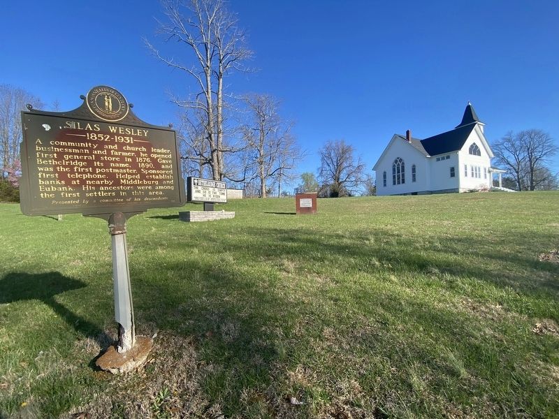
On State Road 70 at Bethel Ridge Road, on the right when traveling east on State Road 70.
A community and church leader, businessman and farmer, he opened first general store in 1876. Gave Bethelridge its name, 1890, and was the first postmaster. Sponsored first telephone. Helped establish banks at nearby Middleburg and Eubank. His . . . — — Map (db m244657) HM
On Courthouse Square at Campbellsville Street (Kentucky Route 70), on the right when traveling south on Courthouse Square.
Present seat of justice, built 1888, was preceded by log building, 1809, and brick structure, 1837. Architects for current courthouse were the noted McDonald Bros. of Louisville. Its asymmetrical design and lavish use of stone trim (by T. D. . . . — — Map (db m83438) HM
On Campbellsville Street (Kentucky Route 70) at Courthouse Square, on the left when traveling west on Campbellsville Street.
Dedicated To
The Memory Of Our Comrades
Who Entered The Service
Of Their Country
From Casey County, Kentucky
And Who Gave Their Lives
In The World War
Erected by the Citizens of
Casey Co. and elsewhere
under auspices of . . . — — Map (db m84102) WM
On KY-70 at Court House Square, on the left when traveling west on KY-70.
Civil War Crossroads
Less than 50 miles north of the Tennessee border, Casey Co. served as a strategic crossroads for Union and Confederate forces stationed in south-central Ky. Both armies had encampments in Liberty and Middleburg at . . . — — Map (db m301970) HM
On Campbellsville Street (Kentucky Route 70) at Courthouse Square, on the right when traveling east on Campbellsville Street.
A spirited USA Civil War leader. Enlisted July 11, 1861. Aided Col. Frank Wolford with recruiting of lst Ky. Cav. Distinctive service many campaigns. Succeeded Wolford in command, Mar., 1864. Mustered out, Dec. 31, 1864. Born, 1839, Pulaski Co. . . . — — Map (db m83441) HM
On North Wallace Wilkinson Boulevard (U.S. 127), on the right when traveling west. Reported permanently removed.
For Col. William Casey, early Ky.
pioneer and great-grandfather of
Samuel J. Clemens, "Mark Twain".
Casey born in Va. Came to Ky. in
1779. Built Casey's Station on
the Dix River in 1791. Member of
Convention, 1799, to frame second
Ky. . . . — — Map (db m301884) HM
On Campbellsville Street at Courthouse Square, on the right when traveling east on Campbellsville Street.
First Kentucky Cavalry
Casey County, home of one-third of this Union regiment and of its commanders Col. Frank L. Wolford and Col. Silas Adams. Others came from eight nearby Ky. counties. Recruited July 1861, trained at Camp Dick . . . — — Map (db m83439) HM
Entered land on Carpenter's Creek 8 miles north, 1780, on a Treasury Warrant for service in Revolution. Land Grant signed, 1783, by Gov. Benj. Harrison. Engaged in Battle of Point Pleasant, 1774. Served in Rockingham Militia, Va., during . . . — — Map (db m83446) HM
This bell was cast by the Whitechapel Bell Foundry in London, England, the same company that cast the original. This bell is an exact duplicate of the original Liberty Bell that arrived in America in 1753. Comprised of tin and copper the bell and . . . — — Map (db m215010) HM
On Lynn Street west of Thompson Street, on the left when traveling north.
Christopher Riffe accompanied Col. Wm. Casey, (Great-Grandfather of Mark Twain); to Kentucky in 1784. He lived at Bryan's Station, Boonesborough, Logan's Station and Carpenter's Station. He bought 800 acres of land from the Grandfather of Abraham . . . — — Map (db m244660) HM
On State Highway 837 at Fishing Creek Road, on the right when traveling north on State Highway 837.
Union Col. Frank Wolford started recruiting for the 1st Ky Cavalry here in July 1861. Unit fought in over 300 engagements, including Perryville & Mill Springs. Local recruits included: Col. Silas Adams, eventual commander of the unit, Eastham . . . — — Map (db m244659) HM
On Fishing Creek Road 0.3 miles east of Jones Road, on the right when traveling east.
Site of one of the first schools in Casey Co. Est. in the 1830s in a log building, was used as church and school. Around the Civil War, school dist. divided into Durham and Utah districts. This became the Utah district school. Area districts . . . — — Map (db m244658) HM
This historic structure was built at the peak of the iron industry in 1868. The furnace once produced high-quality iron used for railroad wheels and rails.
As you roam the grounds and explore this innovative construction, enjoy the opportunity . . . — — Map (db m131603) HM
Welcome to what was once the Fitchburg Furnace Community--a bustling settlement that made its living from the iron and wood resources of these mountains. Fitchburg had mills, shops, and homes for more than 100 families, all engaged in the smelting . . . — — Map (db m131604) HM
Each furnace operation was normally a self-contained community, known as an iron plantation, under the direction of an iron master, usually the owner. Under his direction several types of skilled laborers took part in the overall operation. Miners . . . — — Map (db m131607) HM
The casting house was a wooden shed, which covered the sand moulds where the iron was run. Note the depression in the stone directly above the archway, which probably held the roof of the shed. Long trenches, sloping gradually from the front of the . . . — — Map (db m131609) HM
"Give er fire." This cry ran through the woods as colliers tended huge piles of charring wood, which would be used as fuel at Fitchburg Furnace. Colliers, men who made charcoal, built many coal pits or hearths throughout the mountains during the . . . — — Map (db m131610) HM
On Main Street (Kentucky Route 89) near River Drive ( Route 52), on the left when traveling south.
Only Civil War battle in this area. Col. John S. Scott, CSA, and troops arrived here July 30, 1863, with plan to capture 14th Ky. Cavalry. Held Irvine only a few hours. Col. W. P. Sanders, USA, and his force pursued Scott, capturing some of rear . . . — — Map (db m136806) HM
On Broadway Street (Kentucky Route 2461) at Main Street (Route 89), on the right when traveling east on Broadway Street.
For Captain James Estill, gallant soldier and frontiersman. Fought one of bloodiest Indian battles, Estill's Defeat, on March 22, 1782, in what is now Montgomery County. He and 7 of his 25 pioneers were killed in violent combat with a band of . . . — — Map (db m136805) HM
On Main Street (Kentucky Route 89) south of Orchard Avenue, on the right when traveling south.
Estill Seminary
This site approved for Jefferson Seminary by act of Ky. General Assembly in February 1798. Name was changed to Estill Seminary, February 3, 1816. Trustees given authority to sell half of unclaimed lands, granted for educational . . . — — Map (db m136807) HM
On Main Street (Kentucky Route 89) south of Geneva Avenue, on the right when traveling south.
Mineral springs visited by Boone, Boyle, McAfee and other pioneers. Early camp of Shawnee Indians. First school of early settlers located here. Operated as resort, 1814 until hotel burned 1924. In 1861, owner Col. Sidney M. Barnes organized 8th Ky. . . . — — Map (db m136947) HM
On Main Street (Kentucky Route 89) at Broadway Street ( Route 2461), on the right when traveling north on Main Street.
Named, 1812, for Col. Wm. Irvine, member from Madison Co. of 1787 and 1788 conventions that sought separation from Va. and statehood for Ky.; member of Constitutional Convention, 1799. "He had strong hold on affection of people. Few have gone to . . . — — Map (db m136804) HM
On Tipton Ridge Road (U.S. 52) just east of Cobhill-Patsey Pilot Road ( Route 1182), on the right when traveling north.
Red River Iron Works Blackstone and Chandler Furnaces, a single stone structure 60 ft. high, 40 x 60 ft. Twin stacks 50 ft. high, 12 ½ ft. across inside. Three miles north. Built in 1869 by Sam Worthley, designed by Fred Fitch, with . . . — — Map (db m169099) HM
On Richmond Road (Kentucky Route 52) at Shady Lane ( Route 2473), on the right when traveling north on Richmond Road.
In that crucial battle of the Chattanooga campaign, Nov. 25, 1863, Capt. John C. Wilson and 5 others from Estill Co., of 8th Ky. Inf., answered call for volunteers to plant U.S. flag on Lookout Mtn. Reaching summit in sight of both armies, they . . . — — Map (db m136803) HM
On Richmond Road (Kentucky Route 52) at Shady Lane ( Route 2473), on the right when traveling west on Richmond Road.
Indian Trading Post and camping ground. Called "Ah-wah-nee," a grassy place, by the Shawnees who hunted here and obtained their lead supply in this vicinity. In 1769, Daniel Boone, Squire Boone, and Joseph Proctor were first of many pioneers to use . . . — — Map (db m136802) HM
On Kentucky Route 34 at Fisher Ford Road (County Route 1329), on the right when traveling west on Kentucky Route 34.
Birthplace of Carry A. Nation. With hatchet in hand, this famous Kentuckian harassed saloon owners across U.S. Four miles from here on Carry Nation Rd. is house where she was born, 1846; lived there five years and in other Ky. towns before . . . — — Map (db m70975) HM
On Danville Road (Kentucky Route 52) west of Paulding Street, on the left when traveling west.
Built ca. 1820 on lot #46 of the original town plat. Thomas Buford son of town founder, Wm. Buford., appointed sheriff of Garrard Co. in 1803. He was a member of Ky. Legislature, 1806-09, and served in Senate, 1809. Veteran of War of 1812. In 1841, . . . — — Map (db m67846) HM
On Camp Dick Road North north of Route 34, on the right when traveling north.
Maj. Gen. Wm. Nelson was authorized by President Lincoln to establish, Aug. 1861, first camp south of Ohio River for recruitment of federal troops in Civil War. Named for Richard M. Robinson, a Union supporter, who offered house and farm as . . . — — Map (db m170097) HM
On Lexington Road (U.S. 27) at Danville Street ( Route 52), on the right when traveling south on Lexington Road.
This tablet is dedicated in grateful recognition of Captain William Early Buford
Who served his country with ability during the American Revolution, on June 5, 1797 he sold fifty city lots and gave the “Publick Square” for the . . . — — Map (db m171879) HM
On Danville Road (Kentucky Route 52) west of Stanford Street ( Route 39), on the left when traveling west.
When founded in 1816 by Presbytery of Transylvania, it had 22 members. The first minister was James C. Barnes, who also served Paint Lick Church. Congregation worshiped in the Republican (Union) Church until 1846; second building on Buford and . . . — — Map (db m67844) HM
On Lexington Road (U.S. 27) east of Dora Road (County Route 1363), on the right when traveling north.
Constituted at Forks of Dix River, 1782, by Lewis Craig of "Traveling Church." Log church built here on Sugar Creek. John Routt gave one-acre tract for church and stone edifice erected, 1823. It was later torn down and used for foundation of present . . . — — Map (db m50810) HM
On Lexington Road (U.S. 27) at Danville Street ( Route 52), on the right when traveling south on Lexington Road.
This memorial is dedicated to those Garrard County servicemen who sacrificed their lives for their lives for their country and all Veterans that served their country
World War I
1917- 1919
John Baker • Jesse B. Calico • George H. Calico • . . . — — Map (db m172036) WM
On Stanford Street south of Danville Road ( Route 52), on the right when traveling south.
Taken from parts of Lincoln, Madison, and Mercer, it was the 25th county formed. Lancaster, county seat, established in 1798. Named for James Garrard, then governor of Kentucky, 1796-1804. A native of Virginia, served as militia officer in . . . — — Map (db m67841) HM
On Lexington Street (U.S. 27) north of Maple Avenue, on the left when traveling north.
Built about 1850, by A. A. Burton, Lincoln's Minister to Bogota; home of William O. Bradley, first Republican Governor of Kentucky, 1895-99. By special legislative action, 1865, permitted to take bar examination at 18 and passed. In 1904, seconded . . . — — Map (db m67850) HM
On West Maple Street at Baughman Street, on the right when traveling west on West Maple Street.
Side 1:
Two hundred feet west John Boyle built log cabin, 1798, that is still part of home. He and three others, who later set up housekeeping in that cabin, were state legislators and represented the district in Congress 28 years.
. . . — — Map (db m67848) HM
On Lexington Road (U.S. 27) north of Dora Road (County Route 1363), on the right when traveling north.
Burial site of first Lincoln Co. surveyor, commissioned Jan., 1781. Surveyed this area, then part of Lincoln Co. Daniel Boone was made Deputy Surveyor under him, 1783. Thompson, nephew of Isaac Shelby, was State Rep., Garrard Co., 1803; State . . . — — Map (db m50811) HM
On Lancaster Cemetery Road 6 0.2 miles east of Crab Orchard Street, in the median.
This memorial is dedicated in memory of the known and unknown soldiers of the Civil War and battle of Perryville Kentucky
1861 1865
Sponsored by Lancaster D.A.V. Chapter 25 — — Map (db m171883) WM
On East Maple Avenue east of North Adams Street (a.k.a.: Habit Court), on the left when traveling east.
In early 1776 John Wilson and Andrew Cowan erected two small cabins near this location. In October of 1782 James Speed settled near this spring. In 1797 William Buford chose this spring to furnish water for the new Garrard Court. It continued as . . . — — Map (db m67839) HM
On Lexington Road (U.S. 27) north of Maple Avenue, on the left when traveling north.
Eugenia Dunlap Potts, daughter of George Dunlap, US Congressman and lawyer, was born in Garrard County in 1840 and pursued her literary career here, where she died, 1912. The first of her nine works was "Song of Lancaster," a metrical history in . . . — — Map (db m67849) HM
On Stanford Street (U.S. 27) north of Industry Road (Route 39), on the left when traveling north.
Home of William Owsley and his son-in-law Simeon Anderson. Built about 1815. Owsley, 1782-1862, State House of Representatives and Senate; Court of Appeals; Kentucky Secretary of State and Governor of Kentucky 1844-48. Owsley County named for him. . . . — — Map (db m67842) HM
On Lancaster Road (Kentucky Route 39) at Gilbert Creek Road ( Route 642), on the right when traveling south on Lancaster Road. Reported missing.
In search of religious freedom, the Reverend Lewis Craig led his entire congregation of 200 Baptists and 400 other settlers from Spotsylvania County Virginia and established them here on Gilbert's Creek.
This expedition, guided through the . . . — — Map (db m173233) HM
Near Gilberts Creek Road (Kentucky Route 39) at Lancaster-Crab Orchard Road ( Route 642), on the left when traveling north. Reported permanently removed.
On this site in 1781 Pastor Lewis Craig and Capt. Wm. Ellis and members of the Upper Spotsylvania Virginia Baptist Church established the first church west of the Alleghany Mountains, which is known as the Traveling Church — — Map (db m253667) HM
On Lancaster-Crab Orchard Rd. (State Road 39) near Gilbert's Creek Rd. (County Road 1230), on the right when traveling south.
In search of religious freedom, the Reverend Lewis Craig led his entire congregation of 200 Baptists & 400 other settlers from Spottsylvania Co., Va. and established them here on Gilbert's Creek. This expedition, guided through the wilderness by . . . — — Map (db m254823) HM
Swiss immigrant vinedresser John James Dufour established The First Vineyard, the nation's first commercial winery. A steep slope above the big bend of the Kentucky River, across from the large shipping port Quantico, provided ideal growing . . . — — Map (db m262965) HM
On Richmond Road (Kentucky Route 52) east of County Route 1239, on the right when traveling east.
"The Kentucky Mountain Boy," born at Point Leavell, Garrard County, was radio's pioneer singer of folk songs and ballads in the 1920s-40s. Kincaid began in 1926 at Chicago's WLS; later performed on WSM Grand Ole Opry (1944-50). He recorded over 200 . . . — — Map (db m67837) HM
On Richmond Road (Kentucky Route 52) south of Old Railroad Grade Road (County Route 1104), on the left when traveling south.
Side 1:
500 ft. north is site of log fort and stockade built by Lt. Col. Wm. Miller. Born in Virginia, he came to Kentucky with Daniel Boone's party and helped mark a trace to Boonesboro; served with Capt. James Estill in Battle of Little . . . — — Map (db m67835) WM
On Richmond Road (Kentucky Route 52) near Manse Road (County Route 1140), on the left when traveling west.
Founded 1784 by Rev. David Rice. Early elders of the church: Thomas Maxwell, Alexander Henderson, James Woods, Samuel Woods, Robert Brank, George Denny, Robert Henry. First located in Paint Lick Cemetery. Second building erected circa 1830 on . . . — — Map (db m50812) HM
On Gooch Pike (Kentucky Route 1647) south of Richmond Road ( Route 52), on the left when traveling south.
Site of John W. Walker's home where he and George Washington Maupin, avid hunters, bred and developed famous Walker foxhounds. With red fox migration into central Ky., ca. 1852, Virginia hounds were crossed with "Tennessee Lead," a dog noted for . . . — — Map (db m67838) HM
Along War Fork Creek, two miles east, coursed a primeval trail between the Shawnees of Ohio and Cherokees of east Tennessee. The Indians called it Athiamiowee, Path of the Armed Ones. On English map, 1755. Path was followed by Gabriel Arthur, when . . . — — Map (db m136644) HM
On Main Street (U.S. 421) at 2nd Street, on the right when traveling west on Main Street.
For Andrew Jackson, the 7th US President, 1829-37, first to be elected from west of Appalachians. First Representative in Congress from Tenn., 1796-97. In US Senate twice, 1797 and 1823. Victorious commander at New Orleans, 1815. County formed from . . . — — Map (db m136788) HM
On William Whitley Road, on the left when traveling east.
The races at Sportsman’s Hill began at dawn and were followed by an elaborate breakfast which was prepared in the yard of the house and served out of doors to all the guests. A tradition that continues today at the Kentucky Derby with “The . . . — — Map (db m311785) HM
The threat of an attack by a large Native American raiding party was a very real possibility in 1788 when William Whitley established a horse race track at Sportsman’s Hill. This threat continued for the next six years. By 1794, most attacks were by . . . — — Map (db m105504) HM
On William Whitley Road, on the left when traveling east.
Disagreements in early Kentucky were not always settled by duels, but often, by a horse race, run in a straight course of about a quarter mile distance on the public roads. Quarter horses were specifically bred to run these straight-coursed races. . . . — — Map (db m105499) HM
On William Whitley Road, on the left when traveling east.
Most American celebrations of the 18th and 19th centuries were centered about the agrarian cycle of planting and harvesting. Autumn, the harvest season, was the time for gathering of people to assist with the harvesting of crops and the trading of . . . — — Map (db m105500) HM
Near Cemetery Road (County Route 2032) at Cedar Street.
(south side)
Here,
off duty till the last reveille,
rest the Southern soldiers, few in number,
who were slain
in this and in the adjoining counties,
during the War of Secession.
They fell among strangers,
unknown, unfriended, . . . — — Map (db m258045) WM
On Lancaster Street (Kentucky Route 39), on the left when traveling north.
Site of popular watering place 1827 until early 1930's. Famed for number and excellence of mineral springs. Crab Orchard Salts, medical remedy, produced here by evaporation. — — Map (db m105265) HM
On Main Street (Kentucky Route 39) south of Cherry Street, on the right when traveling north.
Long Hunters, led by Elisha Walden, first recorded the beautiful orchard of crab apple trees in 1763. Soon, the long hunter's trail from Cumberland Gap to Crab Orchard, as it became known, carried a swelling tide of settlers. Crab Orchard, long . . . — — Map (db m105269) HM
On Stanford Street (Kentucky Route 2750) east of Walnut Street, on the right when traveling west.
CSA Gen. J.H. Morgan's cavalry on first Kentucky raid, returning from Cynthiana, burned Dix River bridge above here and camped on July 20, 1862. Burned 120 USA wagons here and at Somerset.
See map on other side.
After battle of Perryville Oct. . . . — — Map (db m105264) HM
Panel 1 Forerunner of Kentucky Derby. Site of one of the earliest circular racetracks. Crowd gathered within the half-mile track, able to see entire race. Built about 1780 by Col. Wm. Whitley, owner of estate. A fervent patriot, he built . . . — — Map (db m103736) HM
On County Route 1369 at William Whitley Road, on the left when traveling west on County Route 1369.
Built at Whitley's Station by Col. William Whitley, noted pioneer and Indian fighter. He was born in Virginia in 1749, came to Kentucky in 1775, and was killed at the Battle of the Thames in 1813. — — Map (db m103726) HM
Sportsman Hill Site of one of the earliest circular racetracks. Crowd gathered within the half-mile track, able to see entire race. Built about 1780 by Col. Wm. Whitley, owner of estate. A fervent patriot, he built track to contrast with the . . . — — Map (db m103731) HM
Before his death in 1813 at the Battle of the Thames, Whitley suspended the highly competitive racing at Sportsman’s Hill when he discovered evidence that a nail had been put in the hoof of his prized horse. However, evidence in family history and . . . — — Map (db m105502) HM
“The Sport of Kings”, or horse racing, has a long tradition within the culture of the British Crown dating back to 1174, when Henry II held the first recorded royal race at Smithfield. James I had a palace and track at Newmarket where he . . . — — Map (db m105503) HM
On Short Pike (Kentucky Route 1562) 0.1 miles north of Route 198, on the right when traveling north.
At the height of the Cold War, on the night of Dec. 12, 1966, the residents of McKinney were startled by the sound of an explosion. Many locals converged on this hill to find a large fiery crater, and the wreckage of an Air Force B-58. All . . . — — Map (db m83448) HM
On Kentucky Route 198 at Durham Street (County Road 1358K), on the right when traveling south on Kentucky Route 198.
Built by Archibald McKinney by 1792, this early trading post was an important stop on Cumberland Trace. The settlement began as four log cabins and a stockade. Early settlers are buried in a cemetery on a knoll visible due south of this marker. In . . . — — Map (db m83454) HM
On Kentucky Route 198 0.1 miles south of Railroad Street, on the right when traveling south.
PFC William B. Baugh, USMC
This Congressional Medal of Honor recipient born near here July 7, 1930. Baugh served with Co. G, 3rd Battalion, First Marines, First Marine Div. (Reinforced). Awarded honor posthumously for gallantry at risk of . . . — — Map (db m83460) HM
On Danville Avenue (County Route 300), on the right when traveling south.
Alcorn Homestead Former home of Sophia K. Alcorn. Born in Lincoln County in 1883, she invented the Tadoma method to teach deaf~blind individuals to speak through the feel of sound vibrations from the lips and cheeks. The method was named for . . . — — Map (db m105362) HM
On Mill Street at Plum Street, on the left when traveling north on Mill Street.
Completed in 1881 and originally named Lincoln Mills, it struggled to be successful until purchased by S. H. Baughman in 1892. Joined by his brothers, Jim and John, and brother-in-law, Walter McKinney, it became J. H. Baughman & Co. The mill ground . . . — — Map (db m105273) HM
On Boneyville Road at Spoonamore Road, on the right when traveling west on Boneyville Road.
One of several “free towns” in Lincoln Co. Created in 1867 from Hugh Hays’ estate and named for founder, Napoleon Bonaparte Hays (1838-1907). “Boney” earned freedom in 1864 enlisting at Camp Nelson as Pvt., Co. C., 12th Regt. . . . — — Map (db m120132) HM
On Danville Road (County Route 300) at Wilderness Road ( Route 150) on Danville Road.
Bright's Inn, a stagecoach stop near the Wilderness Road, was built in 1815 by Capt. John Bright. The original inn was constructed of logs, and, in 1820, a two-story limestone addition was built for travelers going from Lexington to the Cumberland . . . — — Map (db m105361) HM
On East Main Street, on the left when traveling east.
Chiefs Oconostota, Attacullaculla, & Sewanooko signed the Treaty of Sycamore Shoals in 1775 which relinquished Cherokee claims to most of present-day Kentucky. It was the largest land cession in the history of the frontier, up to that time, & led to . . . — — Map (db m105391) HM
On Main Street (Business U.S. 150) at 3rd Street, on the right when traveling west on Main Street.
For Benjamin Lincoln, 1733-1810. Born Mass. In War of Revolution took Mass. Regts. to reinforce New York, 1776; at Saratoga, 1777, cut Burgoyne's communications with Canada; 1778, command of Southern Department. Commissioned by Washington to . . . — — Map (db m299144) HM
On Main Street (Business U.S. 150), on the left when traveling west.
The Stanford Presbyterian Church, founded 1788 on this site, on Old Wilderness Trail. Land given by Mary Briggs, sister of Gen. Benjamin Logan. Church moved to its present site, 1838; land given by Logan, one of founders. In 1797, David Rice, father . . . — — Map (db m49736) HM
On Depot Street at Plum Street, on the right when traveling south on Depot Street.
The Stanford Depot has been a source of heartbreak and joy for the families of Lincoln County since May 17, 1866. The arrival of passenger service meant that loved ones departed, sometimes never to return. The first Louisville & Nashville depot, . . . — — Map (db m105355) HM
On Goshen Church Road/John Logan Trail (Kentucky Route 642) north of Wilderness Trail ( Route 78), on the left when traveling north.
Pioneer, soldier, statesman, John Logan established land claim for 1400 acres in Lincoln County and built stone house here. He was in Lincoln County Militia; member of first Kentucky Court, 1781; Lincoln Co. delegate to Virginia Assembly and to 1787 . . . — — Map (db m218315) HM
The General and Statesman
Isaac Shelby’s military decisions at the Battle of King’s Mountain in 1779 secured a critical victory for America during the Revolutionary War. Before war’s end, Shelby had also served in the North Carolina . . . — — Map (db m120217) HM
Isaac Shelby, soldier, statesman, and surveyor, was Kentucky’s first governor. He served from 1792 to 1796 and was re-elected in 1812.
Shelby came to Kentucky in 1774 when he was hired by the Transylvania Company to survey the new Kentucky . . . — — Map (db m120117) HM
On Main Street at Mill Street, on the left when traveling east on Main Street.
The city of Stanford was incorporated on April 4, 1861 but its history goes back to 1775. Stanford is the second oldest permanent settlement in Kentucky and the county seat of Lincoln County, one of the original three counties of Kentucky. . . . — — Map (db m105363) HM
On 3rd Street at Main Street, on the left when traveling north on 3rd Street.
Benjamin Logan built Logan's Fort at St. Asaphs, mile to west, 1776. Kentucky County, Virginia, formed 1776. First land court, St. Asaphs 1779. Kentucky made into Lincoln, Jefferson, Fayette counties, 1780. In 1785 part of Lincoln taken for Madison . . . — — Map (db m105390) HM
World War I Jasper E. Bennett • Jaceal Blaine • Ed Broner • Jessie D. Carter • Jessie Cummins • Simmie L. Davis • Vernice W. Griffin • William R. Griffin • Charlie Hocker • Joseph Kidd • Walter Manning • John W. Martin • Isaac McCormack • . . . — — Map (db m215026) WM
On Danville Street (Business U.S. 150) at Water Street (or Martin Luther King, Jr. Blvd), on the left when traveling north on Danville Street.
Colonel Benjamine Logan settled here after leaving party of Colonel Henderson at Hazel Patch because of settlement plans. Scene of courageous rescue of fallen companion by Logan in Indian attack – 1777. — — Map (db m49737) HM
On Danville Road (Kentucky Route 150), on the right when traveling north.
Lt. Richard Caswell Saufley This aviation pioneer was awarded two Aviation Medals of Merit by the Aero Club of America: one for efficient air service in an expedition, 1914, and another for breaking the world's altitude record twice in . . . — — Map (db m105409) HM
Daniel McCormack donated land for church, graveyard and school, 1819, to replace log church built by Baptists, circa 1785. Structure was used by several denominations. In 1830 most of original members became affiliated with the Disciples of Christ, . . . — — Map (db m120129) HM
On U.S. 27 at Route 643, on the right when traveling north on U.S. 27.
A German-Swiss settlement, 4 miles southeast, started by immigrants, early 1880s. Guided here by Joseph Ottenheimer "to this land of great opportunity" they found it to be a wilderness. Undaunted they built crude log cabins, then cleared the virgin . . . — — Map (db m67852) HM
Alverson, John S. • Bailey, John • Barnett, James P. • Barnett, Robert • Blaine, Alexander • Bosley, Gideon • Briggs, Benjamin • Bruce, William • Burch, Benjamin • Carpenter, Adam • Carpenter, Conrad • Carpenter, John • Colyer, John • Curtis, . . . — — Map (db m215033) WM
“You triumphed over obstacles which would have overcome men less brave and determined” President McKinley 458,151 • Everyman a volunteer Erected in honor of by the Veterans of the Spanish-American War The Department of Kentucky . . . — — Map (db m215019) WM
On East Main Street (U.S. BUS 150) at 1st Street, on the left when traveling east on East Main Street.
Stanford
Founded 1781, on Wilderness Trail,
by Benjamin Logan.
Established 1786.
Logan built Ft. St. Asaph, 1775.
1st Court House in Ky. 1781. Lincoln Formed 1780, one of 3 original
counties on Ky.
Named for Benjamin . . . — — Map (db m166187) HM
Side 1 The Stanford Female Seminary was incorporated by the Ky. Legislature on Feb. 26, 1869, but the name was changed to the Stanford Female College in 1871. The original brick structure (west side of building) was completed & the college . . . — — Map (db m105358) HM
On Somerset Street, on the left when traveling north.
Side 1 This home was built in 1853 by Dr. Thomas Montgomery, son of James Montgomery, a judge and congressman. His wife, the former Evaline Whitley, was the niece of Gen. Benjamin Logan, founder of Stanford, and granddaughter of Col. William . . . — — Map (db m105396) HM
On Main Street (Business U.S. 150) near Lancaster Street, on the right when traveling west.
Wilderness Road
Benjamin Logan left Boone’s Road, April 15, 1775, following trace that became the final segment of “Wilderness Road.” Logan’s path ran along an obscure trail from this area to Harrodsburg, then to Falls of the . . . — — Map (db m49735) HM
Clay City Timber Industry -With Kentucky Union Railway Company's track laid in Powell Co. in 1886, the area's timber industry expanded. Red River Lumber Mills (1880)became largest steam powered sawmill in Ky. In 1890, the steady run began at . . . — — Map (db m73860) HM
The Red River Museum preserves and interprets the cultural heritage of Powell County and the Red River area. The Museum, home of the Red River Historical Society and headquarters for the Kentucky Old Mill Association, opened in July of 1967. It is . . . — — Map (db m73887) HM
For Gov. Lazarus W. Powell, born Henderson Co., 1812. Graduated, 1833, from St. Joseph's College in Bardstown. Attended Transylvania law school. State legislature, 1836-38, Governor of Ky., 1851-55. U.S. Senate, 1859-65. Resolution for his expulsion . . . — — Map (db m73862) HM WM
Twenty-two Kentucky courthouses were burned during Civil War, nineteen in last fifteen months; twelve by Confederates eight by guerrillas, two by Union accident. See map reverse side. Courthouse and records at Stanton and other buildings were burned . . . — — Map (db m79182) HM
On Washington Street (Kentucky Route 2486) just north of Atkinson Street, on the left when traveling north.
We proudly honor our brave ones who served in the Persian Gulf War Jan. 16, 1991
Baker, Sean D. Sr. •
Banks, Anthony W. •
Blevins, Kevin •
Bowen, Major W. •
Crabtree, Karl J. •
Dixon, James W. Jr. •
Edwards, John G. •
Eversole, . . . — — Map (db m165474) WM
On Washington Street (Kentucky Route 2486) north of Atkinson Street (Route 2476), on the left when traveling north.
This monument is dedicated to all Veterans who served their country in all wars and to the memory of all Powell County Veterans who died in action.
Afghanistan War
SPC John D Morton
WW I
Bert D Hamons •
John . . . — — Map (db m165209) WM
170 entries matched your criteria. The first 100 are listed above. The final 70 ⊳