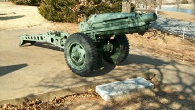
This 75mm Howitzer is a memorial to
1st Lt. Robert F. Trigalet, U.S.M.C.
The first Marine from Bristow who gave
his life for God and Country in the
Vietnam Conflict. (Died May 2, 1969) — — Map (db m41919) HM
This 3 Inch 50mm Deck Gun is
dedicated to Clifford Murl Satterfield
Aviation [Machinist's] Mate First Class
U.S. Navy, Killed in Action
off the U.S.S. Enterprise. South Pacific
April 29, 1944 — — Map (db m41922) HM
On Seventh Street, on the left when traveling west.
In 1895 a concrete walk was installed by the City of Bristow across Main Street at 7th Street. The sloping sides allow the wagons to cross the walk. When Main Street was paved in 1915 the walk was removed. Both the installation and removal were . . . — — Map (db m41941) HM
Near East 7th Avenue west of North Walnut Street, on the left when traveling west.
1920 - Washington Public
School cornerstone.
Once located at 601 South
Poplar, this east side
elementary housed 1st-6th
grade students and was
demolished in 2017.
1929 - Clinic Building and
Hospital lintel.
Once located at 115 West . . . — — Map (db m272842) HM
On Main Street (State Highway 16/66), on the right when traveling north. Reported permanently removed.
[There are several dozen family histories on permanent markers on the plaza. One marker is transcribed, while the names on the other markers are listed for future reference]
The Abrahams [on Panel 1]
Only a little inquiry is needed . . . — — Map (db m41953) HM
VFW Post 3656 dedicates this
U.S. Army Corporal Missile
in memory of
Cpl. Larry E. Caldwell
U.S. Army
Killed In Action
Mar. 19, 1970 in Tam Ky Vietnam — — Map (db m41933) HM
Bristow V.F.W. Post 3656
dedicates this WWI French 75mm Cannon
to Cpl. Peter W. Klingensmith.
First Bristow man killed in action in WWI
and all other Doughboys who served
their country. — — Map (db m41923) HM
On East 7th Avenue just east of Main Street (U.S. 66), on the right when traveling east.
This historic FRISCO train depot was built in 1923. Families and businessmen caught trains here, soldiers departed and returned home from war here, and freight including cotton, peanuts and oil was shipped from this location. Slated for demolition . . . — — Map (db m263568) HM
On West 6th Avenue just west of Main Street (Old U.S. 66), on the right when traveling west.
Dedicated October 25, 1923 ——— Built by A.A. Rollestone — C.L. Freeland Pioneer Bristow Oil Men ——— Dedication ceremony broadcast over pioneer radio station KFJK on one of Oklahoma’s first radio stations ——— This hotel building was the home of radio . . . — — Map (db m263948) HM
Bristow VFW Post 3656 dedicates
this 81mm Mortar to
Sgt.1C Donald J. Hurt,
from Bristow, Co. G, 2nd Bn
279th Inf, 45th Div. U.S. Army,
who was killed in action in the
Korean War April 10, 1952 — — Map (db m41924) HM
On North Chestnut Street south of East 10th Avenue, on the right when traveling north.
Julius Rosenwald Fund. In 1912, Tuskegee Institute President Dr. Booker T. Washington invited Jewish-American philanthropist Julius Rosenwald to serve on the Tuskegee board of directors to help African American education, where rural, . . . — — Map (db m232470) HM
On West 7th Avenue north of Country Club Drive, on the left when traveling north.
March 17, 1937 was a very special day in Bristow as Mrs. Eleanor Roosevelt arrived in town for the dedication of the Klingensmith Park Amphitheater. This facility was built by the combined efforts of the National Youth Administration and the Works . . . — — Map (db m272845) HM
This hatchcover from the WWII submarine USS Batfish SS 310 is dedicated to the men of the U.S. Navy who have given their lives in defense of their country. — — Map (db m41918) WM
By the authority of the Veterans of Foreign Wars of the United States be it known that Comrades
Elbert R. Anderson ∙ Walter G. Bisbee ∙ Edward R. Burris ∙ Clarence A. Davis ∙ Ralph H. Gable, Jr. ∙ Lee J. Johnson . . . — — Map (db m41939) HM
The Veterans of Foreign Wars Post #3656 and the Ladies Auxiliary of Bristow, Oklahoma, honor the men who served in the Spanish American War, World War I, World War II, Korea, and Vietnam, and especially the men listed below who made the supreme . . . — — Map (db m41937) HM
On Main Street near Malley Avenue, on the right when traveling west.
Dedicated to those who
served their country
from a grateful
Depew community
☆ By Name Reflects Killed in Action
Abbett, Chas. R. ∙ Abbett, Geo. E. ∙ Alexander, William ∙ Allee, Marion D. ∙ ☆ . . . — — Map (db m139715) HM
On East Broadway Street (Oklahoma Route 33) east of North Harley Avenue, on the right when traveling west.
Site of the No. 1 F.M. Wheeler, discovery well of the Drumright-Cushing Oilfield. It's completion by C.B. Shaffer, et al, on April 1, 1912, set off one of the greatest "oil booms" in history. The well produced oil for more than 35 years. — — Map (db m213818) HM
On State Highway 33 east of Greenwood Road, on the right.
Site of ranch headquarters was 2-1/2 mi. north of here. Roundups were on present site of Cushing. This area was grazing land for Texas cattle driven north, 1866 to 1885. The region was opened to settlers on Sept. 22, 1892. Sac and Fox village 1/4 . . . — — Map (db m187809) HM
On State Highway 48 at West 11th Street (County Highway 600), on the right when traveling north on State Highway 48.
Began 1/4 mi. east on the Creek Headrights of Tom & Hazel Mann. Town was named for Mann's Ford across Cimarron R. In 1895 G.M Evans leased this 90 acres and surrounding land. AV&W-RR (Frisco) came in 1902 and P.O. est. Apr. 11, 1903. Hall C. Miller . . . — — Map (db m185001) HM
On Coonrod Drive (State Highway 51) at E Trower Blvd, on the right when traveling south on Coonrod Drive.
This area along the Cimarron River Valley with it's many bluffs, caves, overhangs and dense wooded bottom land was a hideout for the infamous Dalton Gang. From 1891 to 1894, Emmett, Grat, and Bob Dalton and their gang robbed trains, stole horses and . . . — — Map (db m284528) HM
On Dewey Avenue (State Highway 66) near Main Street, on the right when traveling east.
Headright oil income of Earle, Creek Roll No. NB988 (a minor), utilized as an investment for him by his father Theodore, Cr. No. 2519 (son of George W.), built this building, completed in 1909.
Earliest Tenants
American National Bank, . . . — — Map (db m41978) HM
On East Taft Avenue (State Highway 117) east of South Division Street, on the left when traveling west.
Creek Indian "Chief" Sapulpa had a ranch, blacksmith shop and store here by 1850. Serving in Confed. Army, he was discharged a Lieut., and is buried N. of his old homestead in cemetery owned by Nancy Green Chap., NSDAR, 2 blks. S. Local RR station . . . — — Map (db m180760) HM
On State Highway 48 0.3 miles south of Old Highway 12 (County Route D138), on the right when traveling south.
Est., 1834, by Lieut. T.H. Holmes, later Lt. Gen., C.S.A. This post was visited~June, 1834~by Gen. Henry Leavenworth on his expedition to the Plains tribes. Edwards' Store, site 1 mile west of here, was the last trading post until Santa Fe on the . . . — — Map (db m64074) HM
On Oklahoma Route 150 0.1 miles south of East 1100 Road, on the right when traveling south.
Cherokee Indian policeman.
First Town Marshal, Tahlequah, Indian Territory, 1890.
Jail guard, Muskogee, Indian Territory, 1893.
Killed at Brush Hill Feb. 27, 1895 when he charged the hideout of Texas outlaws.
“A brave and . . . — — Map (db m282113) HM
On Broadway (Business U.S. 69) at North Avenue, on the right when traveling north on Broadway.
• Was a 2290 mile transcontinental "National Trail" from Winnipeg, Canada to New Orleans, Louisiana;
• Roadway through town ran from North Broadway to Gentry Avenue, then on SW 2nd Street and back to South Broadway;
• Route formed what . . . — — Map (db m73153) HM
On Gentry Avenue (U.S. 266) at 2nd Street, on the right when traveling west on Gentry Avenue.
Established - 1890
Sanctuary Built - 1917
Has been placed on the
National Register
of Historic Places
by the United States
Department of the Interior
November 13, 1984 — — Map (db m73156) HM
On Paul Carr Drive 0.2 miles south of Gentry Avenue (U.S. 266), on the left when traveling south.
Gunner's Mate 3rd Class Paul Henry Carr, USNR (1924-1944), heroic Gun Captain of the After 5-inch Mount of the Destroyer Escort, Samuel B. Roberts (DE-413), died during the battle off Samar, Battle of Leyte Gulf, 25 Oct. 1944. He was awarded a . . . — — Map (db m73155) HM
On Broadway (Business U.S. 69) at Gentry Avenue (U.S. 266), on the right when traveling north on Broadway.
From 1898-1902, ambitious Checotah townspeople invested in the city's future by building impressive red brick Romanesque structures. The Block shown in the antique engraving was planned by Mr. W.E. Gentry, "The Father of Checotah."
This arch . . . — — Map (db m73196) HM
On Selmon Road (State Highway 9) at 2nd Street, on the right when traveling west on Selmon Road.
Birthplace: 2½ miles N.E., 1873
Creek Poet: "Dew and the Bird," "Ode to Sequoyah," and other poems. Columnist: famous "Fus Fixico" letters. Editor, "Muskogee Times" and Eufaula "Indian Journal." Supt. of Creek Orphan School; in charge of . . . — — Map (db m73198) HM
On Business U.S. 69 north of Border Street, on the left when traveling north.
This monument is dedicated to the memory of Pioneer Methodists who built and established Asbury Manual Labor School for Indian children and youth. These stones are from the original buildings. Out of this school came First Methodist Church, . . . — — Map (db m199873) HM
On Business U.S. 69 north of Elm Street, on the left when traveling north.
A plat nearby contains graves moved from behind the Buckner home five miles southeast of here, now inundated by the Eufaula Reservoir.
Henry Frieland Buckner, D.D., his first and second wives, an infant son, the wife of J.S. Murrow, James . . . — — Map (db m199747) HM
On Forest Avenue west of South 6th Street when traveling west.
Greatest ceremonial rite of Creek Indians was Green Corn Dance. It was held at time of year when before corn had fully matured and while grains were soft. Dance was celebration of harvest season and was of intense religious devotion.
In . . . — — Map (db m64184) HM
On Selmon Road west of Main Street, on the left when traveling east.
Mr. and Mrs. T.H. Palmer, Sr. came to Eufaula in a covered wagon in 1915. After settling down he began selling apples from Judge Mills' orchard. Then he built this little store at the edge of town. In 1927 he bought a block of property located . . . — — Map (db m200408) HM
On State Highway 9 at County Road 4110, on the left when traveling west on State Highway 9.
Annie Walker Armstrong (1850-1938), Corresponding Secretary of Woman's Missionary Union, Southern Baptist Convention, made five extended trips to Indian Territory, (now Oklahoma) between 1900 and 1905 to strengthen work among women's mission . . . — — Map (db m284331) HM
Near Honey Springs Battlefield Road 1.5 miles north of East 1020 Road, on the right when traveling north.
Prior to the battle, Confederate
camps were located along either
side of Elk Creek and near the
Honey Springs Depot. Six
thousand men needed ample
room for themselves, their
equipment, tents, wagons, and horses.
With the battle and the . . . — — Map (db m243463) HM
On State Highway 71 5.5 miles west of State Highway 2, on the right when traveling west.
Formerly a strong southerly bend in the Canadian River was located here. The course of the river was permanently changed after the construction of the Lake Eufaula Dam in 1964. It is thought that the bend is named for Cole Younger who served in the . . . — — Map (db m146401) HM
Near Honey Springs Battlefield Road 0.1 miles north of East 1020 Road, on the right when traveling north.
In 1861 the 1st Choctaw and Chickasaw Mounted Rifles was organized under
the command of Choctaw and Chickasaw Indian agent Douglas H. Cooper. After
his promotion to brigadier general, the regiment served under Choctaw Col.
Tandy Walker. The . . . — — Map (db m243458) HM
On 11th Street 0.6 miles north of Gertrude Avenue, on the right when traveling north.
On July 17, 1863, at the Battle of Honey Springs, the 1st Kansas Colored Volunteers wrote a stirring page in American history, becoming one of the first Black units of the Civil War to play a key role in a Union victory as Major General James G. . . . — — Map (db m80514) HM
On North Intosh Street north of Gertrude Avenue, on the left when traveling north.
All-Black Towns of Oklahoma
The All-Black towns of Oklahoma represent a unique chapter in
American history. No where else, neither the Deep South nor the Far
West, did so many African American men and women come together to
live in and . . . — — Map (db m243922) HM
Near 11th Street 0.6 miles north of Gertrude Avenue, on the right when traveling north.
America's battlefields inspire us to contemplate the meaning of the battle,
its causes, consequences, and cost. They connect us to our past through such timeless virtues as duty, loyalty, honor, and courage, as well as cowardice, brutality, fear, . . . — — Map (db m243452) HM
Near Honey Springs Battlefield Road 0.2 miles north of East 1020 Road, on the right when traveling north.
Those who died were quickly buried, often where they lie, as the
summer heat and the high humidity led to unbearable conditions.
In 1868 contractors were hired to open the graves and remove bodies
whose uniforms had US buttons. These were . . . — — Map (db m243460) HM
On 11th Street 0.6 miles north of Gertrude Avenue, on the right when traveling north.
"Lord God of Hosts be with us yet, lest we forget, lest we forget" This commemorative marker is respectfully dedicated to honor the brave soldiers of the Confederate States of America who gallantly fought and died here on July 17, 1863. The Battle . . . — — Map (db m52289) HM
On 11th Street 0.6 miles north of Gertrude Avenue, on the right when traveling north.
Order Of Battle (Indian Units)
Federal Forces:
First Indian Home Guard (Cherokee)
Second Indian Home Guard (Cherokee)
Confederate Forces:
First Choctaw Regiment
Second Choctaw Regiment
First Chickasaw and Choctaw Regiment . . . — — Map (db m52286) WM
On 11th Street 0.6 miles north of Gertrude Avenue, on the right when traveling north.
The Texas Road was the main route traveled by settlers and traders from Missouri and
Kansas to Texas. The small community of Honey Springs, named for several natural springs in the area, developed near the road. There were a few buildings, among . . . — — Map (db m243450) HM
Many resources give us information on the Civil War, including battle reports,
diaries, letters, and on-the-spot reporting. Interviews with those who participated in or were affected by the war, as well as their memoirs, offer firsthand . . . — — Map (db m243454) HM
On Honey Springs Battlefield Road 0.1 miles East 1020 Road, on the right when traveling north.
Variously known as the Combs, Lane or
McIntosh Cemetery, this burial ground was
incorporated by the Pumpkin Ridge Cemetery
Association in the 1920's. As a private entity,
no state manpower or funds can be used on it's
upkeep.
A Confederate . . . — — Map (db m243505) HM
Near Honey Springs Battlefield Road north of East 1020 Road, on the right when traveling north.
Following their overnight 20-mile
march from Fort Gibson and the day-long
battle, the Federal soldiers were exhausted.
The units camped on the battleground
on both sides of Elk Creek. The next day
part of the Federal Army marched back to
Fort . . . — — Map (db m243462) HM
Near 11th Street 0.6 miles north of Gertrude Avenue, on the right when traveling north.
Brig. Gen. Cooper held Scanland's and Gillette's cavalry squadrons in reserve to
guard the supply depot. As the battle progressed, he ordered the squadrons to join the
Creek regiments protecting his left flank. When the Confederate troops started . . . — — Map (db m243451) HM
On Honey Springs Battlefield Road 0.1 miles north of East 1020 Road, on the right when traveling north.
The last organized Confederate resistance occurred here. As Federal troops pushed south along the Texas Road toward the Honey Springs Depot, they encountered the 1st Choctaw and Chickasaw Regiment. Armed largely with shotguns and antiquated weapons, . . . — — Map (db m243457) HM
Near Gertrude Avenue east of 11th Street, on the left when traveling east.
Prior to the movement of settlers into Texas in the 1830s and 1840s, the
northern portion of the road, which passed through what would later
become Honey Springs, was known as the Osage Trace. During the late
18th and early 19th centuries, the . . . — — Map (db m243507) HM
Near Honey Springs Battlefield Road 0.2 miles north of East 1020 Road, on the right when traveling north.
The medical and surgical materials available in the field were
generally limited to what the surgeon carried in his case,
known as the surgeon's field companion. The regimental hospital steward
carried a hospital knapsack--a bulky, cumbersome . . . — — Map (db m243459) HM
On 11th Street 0.6 miles north of Gertrude Avenue, on the right when traveling north.
"We here highly resolve that these dead shall not have fallen in vain" This commemorative marker is dedicated to the memory of the Union soldiers who bravely fought and died here on July 17, 1863. Major General James G. Blunt began moving 3,000 . . . — — Map (db m52288) HM
On Honey Springs Battlefield Road 0.1 miles north of East 1020 Road, on the right when traveling north.
William Frederick McIntosh was the second son of Chilly McIntosh and
Leah Porter. He served under his uncle, Daniel Newnan McIntosh, as
Captain of the First Regiment of Creek Mounted Volunteers for the
Confederacy in the Civil War. He owned the . . . — — Map (db m243502) HM
On Cemetery Road 0.1 miles east of Sterling Hill Dr.
Civil War Dead
An estimated 700,000 Union and Confederate soldiers died in the Civil War between April 1861 and April 1865. As the death toll rose, the U.S. government struggled with the urgent but unplanned need to bury fallen Union troops. . . . — — Map (db m284377) HM
On East Ash Avenue just east of Lee Street, on the left when traveling east.
Originally built on this site by the United States Army, Colonel Matthew Arbuckle and the United States Infantry. Rebuilt by WPA and the State of Oklahoma in 1935-36. The exact duplicate of the original. — — Map (db m136565) HM
On W Poplar StReet at E Railroad St, on the left when traveling north on W Poplar StReet.
Founded April 21, 1824, by Col. Matthew Arbuckle, 7th. Inf., farthest west in chain of forts, north to south, to guard western frontier. Named for Col. George Gibson. More than 100 West Point graduates, including Lt. Jefferson Davis, served at Ft. . . . — — Map (db m284375) HM
On Cemetery Road 0.1 miles east of Sterling Hill Dr.
Civil War Fort Gibson
The U.S. Army established a post here in 1824 and named it for Col. George Gibson, the army's first commissary general. Thirty-three years later, the federal government turned the fort over to the Cherokee Nation, which . . . — — Map (db m284383) HM
On North Lee Street at E Blackjack, on the right when traveling north on North Lee Street.
In December 1832, the Rev. John Fleming, Presbyterian Missionary, arrived at Fort Gibson to take up the work of chaplain for the soldiers at the fort and settlers in the area of the fort, and also, as a missionary to the Creek Indians, who were . . . — — Map (db m284387) HM
On U.S. 62 0.5 miles east of South Manard Road, on the right when traveling west.
Site of Manard Settlement on Bayou Menard. Named for Pierre Menard (1766-1844. Menard, an early day fur trader, merchant and member of the Chouteau family. Served as the first territorial governor of Illinois.
Springs at Manard identified . . . — — Map (db m52605) HM
On South Lee Street at Business U.S. 62, on the right when traveling south on South Lee Street.
This marker commemorates the men and women who achieved American independence. These Patriots, believing in the noble cause of liberty, fought valiantly to found a new nation.
Presented by Oklahoma Society Daughters of the American Revolution . . . — — Map (db m284391) WM
On East Ash Avenue just east of Lee Street, on the left when traveling east.
The first commercial long distance telephone line in Oklahoma was placed in service here in 1886. It connected Fort Gibson with Tahlequah and Muskogee. The line was built by a company formed by a group of Cherokees, namely L.B. Bell, J.S. Stapler, . . . — — Map (db m136566) HM
On Cemetery Road 0.1 miles east of Sterling Hill Dr.
In honor of those who gave the Ultimate Sacrifice in service to the United States of America and the families they left behind. The sacrifice will not be forgotten. — — Map (db m284376) WM
On Broadway (U.S. 62) south of Spruce Street, on the left when traveling south.
[Honor Roll of Veterans]
(back)
The Town of Haskell
This memorial testifies to future generations our everlasting appreciation for all Korean War Veterans. Some gave much, others gave all. Yours was a much appreciated gift . . . — — Map (db m108959) HM WM
On Chickasaw Avenue/194th Street West (State Highway 72) 1 mile Haskell Boulevard (U.S. 64), on the right when traveling north.
Toll Donaghe • WW I • 1918
Lee Elliott • WW II • 1943
Donaghe - Elliott
Post 56
Haskell Oklahoma
Chartered 1934
Honoring
All American Veterans
In times of trouble and of war
God and the Soldier we all adore
With trouble ended and . . . — — Map (db m111692) WM
On U.S. 64 0.7 miles south of Skelly Road (County Route E0830), on the left when traveling south.
First peace council and alliance in Oklahoma between a European nation and Indian tribes held here at a Tawakoni village by Comdt Bernard De La Harpe on his first visit to the Arkansas River. He erected a post here carved with the coat-of-arms of . . . — — Map (db m77867) HM
On Chickasaw Avenue/194th Street West (State Highway 72) 1 mile north of Haskell Boulevard (U.S. 64), on the right when traveling north.
Dedicated to the men
and women of Haskell
who served their
country with honor
In Memoriam
1917 - 1918
Toll Donaghe
1941 - 1945
Raymond Harmon • Lee Elliott, Jr.
Tommie Riddle • Arthur Miller
Joe S. Ferguson • Ralph Cantrell . . . — — Map (db m111690) WM
In memory of
Benjamin Howard Gaston, M.D.
1926 - 1997
1947 - Graduated
Johns Hopkins Medical School
Captain, United States Army
Surgical Research Unit
Brooke Army Medical Center
In honor of
forty years of surgical service . . . — — Map (db m108930) HM WM
This open air theatre is dedicated as a living memorial to our comrades of World War I and World War II who gave their lives in the service of their beloved country.
It looks across to the Cookson Hills, the site of Camp Gruber, where the . . . — — Map (db m108931) HM WM
On Honor Heights Drive, on the left when traveling north.
The American Society of
Landscape Architects
1899-1999
This site is recognized as
a National Landmark for Outstanding
Landscape Architecture — — Map (db m108934) HM
On Old Bacone Road east of Daniel Rogers Road, on the right when traveling east.
Built and completed in 1932 as an art lodge, this pioneer-style building became a focal point for many college activities, as well as housing the college's extensive artifact collection as a museum for many years. The building was constructed . . . — — Map (db m251420) HM
On Old Bacone Road north of Daniel Rogers Road, on the left when traveling north.
Wacoche Hall was Bacone College's first stand-alone dining hall built in 1924 thanks to a generous donation by its namesake Benjamin Wacoche, Creek, of Coweta, OK. The building was erected at a cost of $50,000, with $20,000 being donated by Benjamin . . . — — Map (db m251388) HM
Iron Sculpture by
John Carson,
Muskogee Artist
Contributed by
Marie White Rhodes
in Commemoration of
Dr. John Hutchings White
pioneer Physician and Surgeon who emigrated
from Virginia to Indian Territory in 1902 to work
among the . . . — — Map (db m108936) HM
On York Street (State Highway 16), on the left when traveling north.
Established Nov. 1861 by Gen. Albert Pike, C.S. Army. Named for Pres. Jefferson Davis, who had been stationed in the area when a Lieut. U.S. Army. Nearly one million dollares spent on this post by Confederates. In Second Federal Invasion Ft. Davis . . . — — Map (db m52277) HM
On Old Bacone Road at East Shawnee Road, on the left when traveling north on Old Bacone Road.
Founded as Indian University
Tahlequah Indian Territory
February 9, 1880 by Almon C. Bacone
moved to Muskogee, Indian Territory
June 1885
Plaque on right hand column
This Gateway Erected by
the Oklahoma . . . — — Map (db m251436) HM
On North 6th Street just south of Court Street, on the right when traveling north.
The present building was constructed at Sixth and Broadway in 1905 and was moved to this site and enlarged in 1923. Church HistoryThe first Episcopal Bishop of Oklahoma Indian Territory the Rt. Rev. Francis Key Brooke established Grace Church . . . — — Map (db m259698) HM
385 entries matched your criteria. The first 100 are listed above. Next 100 ⊳