On Gunderson Road just south of Elevator Road, on the right when traveling south.
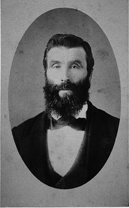
This site, on the world's greatest salmon river, lured many pioneer canners in the late 1860's and early 1870's. Pre-eminent was Alexander Ewen, a founder and first president of B.C. Packers, who established a cannery here in 1871. The new salmon . . . — — Map (db m187923) HM
On Royal Avenue at Merivale Street, on the right when traveling east on Royal Avenue.
Arriving in British Columbia from the United States in 1859, Scottish-born Capt. William Irving pioneered the riverboat trade of the lower Fraser River. In 1862-64, Royal Engineers built his fine home of California redwood in the popular San . . . — — Map (db m187992) HM
On Esplanade Avenue, 0.4 kilometers north of Murray Street, on the right when traveling north. Reported missing.
Colonel R.C. Moody, R.E., recognized the potential value of Burrard Inlet for military defence. Named in his honour, Port Moody became the western terminus of the Canadian Pacific Railway. Although a branch line was built in 1887 to the growing city . . . — — Map (db m187971) HM
In commemoration of the tenth anniversary of the terror attacks of September 11, 2002, the United States Consulate General in Vancouver, on behalf of the people of the United States, wishes to thank the people of British Columbia for their support . . . — — Map (db m236164) HM
On Water Street, on the right when traveling west.
William Harold Malkin, a wholesale grocer and general merchant, built three warehouses on Water Street within eight years. This massive brick and timber warehouse, his third, was constructed to meet the growing demand. The W.H. Malkin Co. prospered . . . — — Map (db m236408) HM
On Stanley Park Drive, on the left when traveling west.
You are standing on thousands of years of history. The clearing around Lumbermen's Arch has been the perfect gathering spot for generations.
Place of the Mask
The local Coast Salish named this site Xwdyxway (pronounced whoi . . . — — Map (db m236022) HM
On Carrall Street, on the left when traveling south.
This hotel dates back to 1887, part of the rapid development of the city prior to and upon arrival of the Canadian Pacific Railway. The original hotel here, known as Tremont House, was a wood frame building with a second floor balcony spanning the . . . — — Map (db m236472) HM
On West Hastings Street, on the right when traveling north.
BC & Yukon Chamber of Mines
Architect: John C. Day
This was built in 1926 as the corporate offices for the Royal Financial Trust Co., in Classical and Gothic ornamentation with terra cotta cladding. By 1931 the company was . . . — — Map (db m236785) HM
Near Stanley Park Drive, on the right when traveling west.
During its heyday, the Brockton Point Lighthouse played a key role in guiding ships safely in and out of Coal Harbour.
Early Warning System
The first Brockton Point lighthouse, built in 1890, alerted ships to shore-related dangers and . . . — — Map (db m198612) HM
Built to service the trading forts of the Hudson's Bay Company, the BEAVER regularly steamed the H.B.C.s territory between Puget Sound and Russian Alaska for 24 years. In 1862, the BEAVER was chartered to the Royal Navy and, after a refit, began a . . . — — Map (db m236206) HM
CARVED IN 1987 BY NISGA’A ARTIST NORMAN TAIT ALONG with his son Isaac, brother Robert, and nephew Ron Telek, this pole depicts how the Tait family's Eagle clan adopted the beaver as their crest, and how the eagle and raven met and shared the . . . — — Map (db m236192) HM
The local Coast Salish people gathered clams and mussels along these shores when this lagoon was a saltwater inlet of Coal Harbour.
[caption] Lost Lagoon got its name in the earl 1900s from Canadian poet Pauline Johnson, who presented the name . . . — — Map (db m236365) HM
On Carrall Street, on the left when traveling north.
The Byrnes Block was built after the fire of 1886 by George Byrnes. It stands on the site of the Deighton House, Gassy Jack Deighton’s second saloon and hotel.
The buildings housed the Alhambra Hotel, one of the city's fancier hotels at the . . . — — Map (db m236463) HM
Canada Pacific Railway Station
Architects: Barott, Blackader & Webster
As the terminus for the Canadian Pacific Railway, this site has been an important landmark since the completion of the railway in 1886. This Neo-Classical . . . — — Map (db m236312) HM
From May 2, to October 13, 1986, Canada Place was the home of the Canada Pavillion at the 1986 World Exposition. The Canada Pavillion images depicted in this sculpture represent the enterprise, excellence, and beauty of Canada, whose . . . — — Map (db m236378) HM
Canada Place was the Canadian Pacific Railway's Pier B-C ocean liner terminal in the 1920s. In 1982, the Government of Canada redeveloped it as the Canadian Pavilion for The Expo '86 World Fair and dedicated it as a legacy for the Canadian people. . . . — — Map (db m236308) HM
On West Hastings Street, on the right when traveling east.
Ceperley Rounsefell Building
Architects: Sharp and Thompson
Built in 1921, this was the headquarters of one of the province's largest insurance and real estate firms with roots going back to the city's incorporation. Henry . . . — — Map (db m236783) HM
AN OLDER VERSION OF THIS POLE WAS RAISED IN THE Haida village of Skidegate about 1870. It honours the Raven Chief of Skedans and depicts the chief's hereditary crests. The two tiny figures in the bear's ears are the chief's daughter and son-in-law . . . — — Map (db m236187) HM
IN KWAKWAKA'WAKW (KWAKIUTL) CEREMONIES, CARVED staffs called talking sticks are held by people making important speeches on behalf of a chief. This pole represents the talking stick and characters in an Owikeno story belonging to Chief Wakas. The . . . — — Map (db m236193) HM
Cordage Building
Architect: Hugh Braunton
This residential hotel built in 1911 replaced an older section of the Granville Hotel which had connected to what is now the Grand Hotel to the west. Its elegant Edwardian and Classical . . . — — Map (db m236411) HM
Near Stanley Park Drive when traveling north. Reported missing.
Originally built to access the North Shore, the Lions Gate Bridge is now one of the city's busiest thoroughfares with over 60,000 vehicles driving across each day.
Tension over the Suspension
In 1927, Vancouverites voted against building a . . . — — Map (db m198590) HM
Near Stanley Park Drive, on the right when traveling west.
As ships navigated the Narrows' powerful tidal flows, they relied on warnings from the Prospect Point Lighthouse to stay clear of its rocky hazards.
Response to Disaster
In 1888, just off this point, the historic steamship S.S. Beaver ran . . . — — Map (db m198611) HM
Once a thriving logging town, the downtown of Vancouver's skyline is now dominated by
residential and retail developments, corporate headquarters, hotels and the distinctive
"sails" of the convention and cruise ship centre. The City of Vancouver . . . — — Map (db m236126) HM
James Till PhD and Ernest McCulloch MD are globally recognized as the Fathers of Stem Cell Science for their research in the 1960s at the Ontario Cancer Institute and Princess Margaret Hospital, Toronto. They received Canada's Gairdner . . . — — Map (db m236487) HM
On Water Street at Cambie Street, on the left when traveling west on Water Street.
On this site the Regina Hotel, the only building in Gastown to survive the fire of 1886. A small group of men trapped in the building fought to save their lives and managed to save the building as well. The Regina was demolished in 1906 and replaced . . . — — Map (db m236401) HM
On West Hastings Street at Granville Street, on the left when traveling north on West Hastings Street.
In 1888, the Bank of British Columbia and the Bank of Montreal became the first of many financial institutions to open their offices on Hastings Street west of Cambie. By 1912, Hastings was firmly established as the city's financial district with . . . — — Map (db m236313) HM
First Known AIDS Memorial
Planted on October 20, 1985
The grove was planted, and this plaque donated by staff friends and loved ones of AIDS Vancouver.
This grove of cherry trees is a living monument, planted in loving . . . — — Map (db m236211) HM
In the area then known as West Capilano, and today as Ambleside, a former Canadian Pacific Railway conductor. John Lawson, purchased land in 1906. He moved his family there the following year, Lawson had big ideas for his land, which he christened . . . — — Map (db m235892) HM
This grassy area, now Devonian Harbour Park, represents lavers of historic use from early settlement to industrial waterfront.
Coal Harbour
In 1859 Captain George Henry Richards from the British Royal Navy named this bay Coal Harbour, . . . — — Map (db m235893) HM
GA'AKSTALAS, CARVED BY WAYNE ALFRED AND BEAU DICK IN 1991, is based on a design by Russell Smith. The pole depicts many important figures in Kwakwaka'wakw culture. Red Cedar-bark Man is an ancestor who survived the great flood and gave the people . . . — — Map (db m236188) HM
This clock is located at the western boundary of the old Granville townsite, known as Gastown. In 1870, the shore of Burrard Inlet was only a few yards north of this point. Through the early 1900's, Gastown was the commercial centre of Vancouver. . . . — — Map (db m236389) HM
George Leslie's Lane Cottage
Builder: George Leslie
This circa 1901 Yaletown home was relocated to Mole Hill in 2002 and restored by the Vancouver Heritage Foundation. It was originally situated on the lane at [t]he rear of . . . — — Map (db m236746) HM
On Water Street, on the right when traveling west.
Greenshields Building
Builder: J.J. McLuckie
This former Warehouse was constructed in 1901-02 as two separate buildings designed to appear as one. Greenshields, Son & Company was a prominent Montreal-based dry goods firm which . . . — — Map (db m236396) HM
Commemorating the pioneering of the work of the Salvation Army in Vancouver. It was on this clearing the Salvation Army erected a rugged shelter, picnic tables, and then held services of song. In the silent atmosphere of early Burrard Inlet, the . . . — — Map (db m236209) HM
"The will to do, the soul to dare"
Sir Walter Scott
Harry Winston Jerome
Born September 30, 1940
Died December 7, 1982
British Columbia's Athlete
of the Century 1871-1971
World Records
1960 100 yards 9.3 seconds
. . . — — Map (db m236027) HM
Her Majesty's Canadian Ship Discovery was commissioned on November 1, 1941. Thousands of men and women have been recruited and trained at these naval reserve facilities of Deadman's Island for service to Canada in peace and war.
World War . . . — — Map (db m236197) HM
On West Georgia Street at Howe Street, on the right when traveling north on West Georgia Street.
This distinguished hovel designed in the Georgian Revival style was opened in 1927 by Edward Prince of Vale, who later became King Edward VII. Though the 1920s prominent buildings such as this were quickly replacing the area's early houses and . . . — — Map (db m236323) HM
On Hornby Street, on the left when traveling north.
Architects: John S. Archibald & John Schofield
In 1887, the first Hotel Vancouver opened at Georgia and Granville Streets. It was replaced in 1916 by more lavish building at the same location. In 1928, construction began on the third and . . . — — Map (db m236318) HM
The totem was the British Columbia Indian's "Coat of arms", totem poles are unique to the North west coast of B.C. and lower Alaska. They were carved from western red cedar and each carving tells of a real or mythical event. They were not idols, nor . . . — — Map (db m236186) HM
This ancient symbol of the Inuit culture is traditionally used as a landmark and navigational aid and also represents northern hospitality and friendship. Constructed of grey granite by Alvin Kanak of Rankin Inlet, this monument was commissioned by . . . — — Map (db m236351) HM
Jack Poole was a giant or a man, a builder of better communities who voluntarily provided
exceptional leadership with an unwavering commitment to the public good as exemplified by his extraordinary service as Chairman of the Vancouver Organizing . . . — — Map (db m236212) HM
KWARWARA' WARW CARVER ELLEN NEEL AND HER UNCLE Mungo Martin were among the first artists to achieve wide recognition for their totem poles commissioned by museums, cities, and art collectors. Neel was also the first woman to become a Northwest . . . — — Map (db m236194) HM
On May 23, 1914, the steamship Komagata Maru arrived in Coal Harbour after a seven week crossing from Hong Kong via Japan. The ship was carrying 376 Indians from India and the Far East who claimed right of entry as citizens of the British Empire. . . . — — Map (db m236311) HM
The Guinness brewing family built the Lions Gate Bridge which opened in 1938 to provide access to its British Properties lands in West Vancouver. Ownership was transferred to the Province in 1955. Tolls were removed in 1963 and the bridge was . . . — — Map (db m236789) HM
This was one of the first parking garages in Vancouver, opened in 1930. It was operated by Nagle Bros. until 1937, an early service facility for tracks that moved goods from Gastown warehouses. In the late 1940s it became the Water Street Garage. . . . — — Map (db m236412) HM
On Granville Street, on the right when traveling north.
Orpheum Theatre
Architects: B. Marcus Priteca & Frederick J. Peters
The Orpheum, built and financed by local entrepreneur Joseph F. Langer, was part of the Chicago-based Orpheum Circuit theaters. It opened in 1927 as the largest . . . — — Map (db m236733) HM
FIRST NATIONS ORIGIN STORIES TELL OF THE ANIMALS AND supernatural beings who helped found family lineages. These stories are celebrated in songs, dances, and totem pole carvings. Kwakwaka'wakw artist Oscar Maltipi carved this pole in 1968. . . . — — Map (db m236190) HM
On Expo Boulevard, on the left when traveling west.
Percy williams blasted down the track in Amsterdam at the 1928 Olympic Games to win gold in the 100 and 200 meter sprints. His unexpected Olympic victories catapulted the twenty year old, and his hometown of Vancouver, into the international . . . — — Map (db m236713) HM
This statue of Robert Burns, Scotland's National Bard, was unveiled by J. Ramsay MacDonald, a Prime Minister of Britain, on 25th August, 1928.
Robert Burn's sincere desire for friendship and brotherhood among all people is clearly shown in his . . . — — Map (db m235907) HM
The Robinson Block was built in 1889 Zebulon Franks, a Jewish immigrant from Russia who arrived in 1887, relocated his general supply store here from Carrall Street in the early 1890s. It catered to resource industry workers - loggers, fishers, . . . — — Map (db m236403) HM
On Barclay Street, on the right when traveling north.
Roedde House
Attributed to Francis Mawson Rattenbury
This Queen Anne style home of Vancouver's first bookbinder was built by Gustav and Matilda Roedde in 1893. Efforts to restore the house and establish a unique heritage park . . . — — Map (db m236348) HM
Developed to reflect the aspirations of early Vancouver, the Shakespeare Garden is a secluded arboretum of trees mentioned in the Bard's plays and poems.
The first tree was planted by Mrs. Jonathan Rogers in 1916 on the three hundred year . . . — — Map (db m236203) HM
"Our art comes from spirituality. From after the onslaught of another culture, our spirituality and our belief are alive. In this pole we wanted to acknowledge the arts and ceremonies of our grandparents' generation and show that the arts are here . . . — — Map (db m236191) HM
On Jervis Street, on the left when traveling west.
St. Paul's Anglican Episcopal Church
Architect: W.H. Archer
This attractive wooden Gothic Revival church, built in 1905, was modelled after a typical English Parish church. Regional influences in the building can be seen in . . . — — Map (db m236749) HM
The first public garden of the city was created from 1911 to 1920 by master gardener John Montgomery from unwanted boulders excavated for the adjacent park pavilion. Stretching from Pipeline Road to Coal Harbour this early park attraction, had by . . . — — Map (db m236204) HM
On Water Street, on the right when traveling east.
Taylor Building
Architects: Grant & Henderson
Walter Taylor and Edward Clarence Taylor commissioned this commercial building in 1911. Walter Taylor was the founder and managing director of the Empress Manufacturing Company, . . . — — Map (db m236398) HM
Terry Fox Plaza
Terrance Stanley “Terry” Fox
July 28, 1958 – June 28, 1981
Terry Fox was a young athlete from the Vancouver suburb of Port Coquitlam. In 1977, at the age of 18, he was diagnosed with osteosarcoma in his right knee. . . . — — Map (db m236717) HM
On Nelson Street at Howe Street, on the left when traveling north on Nelson Street.
Vancouver's postmaster, Jonathan Miller, hired four mail carriers to commence delivery in the city. Citizens were instructed regarding proper numbering and servicing began February 1, 1895, from the main post office at the N.W. corner of Granville . . . — — Map (db m236743) HM
The world's first steam powered clock has been created for the enjoyment of everyone. The live steam winds the weights and blows the whistles. Every 4.5 minutes one steel weight will travel by steam power to the top of the clock. The gravity driven . . . — — Map (db m236391) HM
The Grand Motel was built in 1889. It was known as the Granville Motel until its expansion in 1904. Designed by Noble Stonestrott Hoffar, one of Vancouver's earliest architects, it is a fine example of the Victorian Italianate style, and one of . . . — — Map (db m236409) HM
Near Lions Gate Bridge (Provincial Highway 99) north of Stanley Park Drive, on the right when traveling south.
[English] A tribute to the engineers who built and renovated this bridge, the landmark structure of the Vancouver area.
When opened in 1938, the 1550 ft. main span was the longest suspension span outside the United States. Design engineer: . . . — — Map (db m198610) HM
Following the longest national torch relay in Olympic History, the Olympic Cauldron was lit on February 12, 2010 marking the official opening of the Vancouver 2010 Olympic and Paralympic Winter Games.
Arriving from Athens, Greece, the Olympic . . . — — Map (db m236213) HM
On Water Street, on the right when traveling west.
Originally built as The Sunnyside Hotel in 1874, the property was devastated by the Great Vancouver Fire in 1886. It was rebuilt and operated as The Alexandra Hotel for several years. As of 1912, the building was home to Swift Canadian Company, a . . . — — Map (db m236457) HM
First planted by the Kiwanis Club in 1920, the Stanley Park Rose Garden now displays over 3500 bushes and features a wonderful arbor which is bedecked with the blossoms of climbing varieties throughout the summer. — — Map (db m236867) HM
Thomas Fee House
Architects: Parr and Fee
This early West End home was designed and built in 1904 as the private home of Thomas Fee, a partner in the well-known architectural firm of Parr and Fee. The firm was responsible for the . . . — — Map (db m236747) HM
This sundial commemorates three English Greenhorns Samuel Brighouse, John Morton, and William Hailstone who in 1862 filed the first claim and planned the first home and industry in the heavily wooded area now bounded by Burrard Inlet, Stanley Park, . . . — — Map (db m236361) HM
CARVED HOUSE POSTS ARE USED IN TRADITIONAL FIRST Nations cedar houses to support the huge roof beams. This pole is a replica of a house post carved by Kwakwaka' wakw artist Charlie James in the early 1900s. Tony Hunt carved this replica in 1987 to . . . — — Map (db m236189) HM
By 1865, fortunes were made in BC, thanks to world demand for the plush pelt of the northern seal.
Sealing dominated the city of Victoria's economy for nearly 50 years. At its height, 122 schooners employed over 3,000 hunters, the majority . . . — — Map (db m236307) HM
Park visitors have long gathered here, at the Stanley Park Pavilion and Malkin Bowl, to enjoy food, music and social pursuits.
GETTING TOGETHER IN STYLE
The pavilion built in 1911, became hub of social activity as one of Vancouver's . . . — — Map (db m236865) HM
On Granville Street, on the right when traveling north.
Bright lights, glamorous decor, and streamlined forms are features which make the Vogue a magnificent example of the Art Deco style. Built by the Odeon chain in 1941, the theatre was unusual in its ability to accommodate both movies and . . . — — Map (db m236740) HM
[Left]
"What an object lesson of peace is shown today by our two countries to all the world. No grim-faced fortifications mark our frontiers, no huge battleships patrol our dividing waters, no stealthy spies lurk in our tranquil border . . . — — Map (db m235996)
You can thank Vancouver's early shipping activities for this viewpoint -originally the site of a signal station that guided ships through First Narrows.
Towering Beacon of Safety
A two-storey signal station once sat atop . . . — — Map (db m236128) HM
Asbestos causes 40 percent of work-related deaths in North America.
The installation recalls the ominous history of asbestos from when it was heralded as a "magic mineral" to recognition of its devastating impact on human health.
. . . — — Map (db m236306) HM
The violent windstorm of December 2006 severely damaged more than 10% of the Stanley Park forest, downing over 10,000 trees as well as damaging the Prospect Point escarpment and the seawall below. The public response was an outpouring of financial . . . — — Map (db m236127) HM
On West 10th Avenue, on the right when traveling east.
Grocer Fred Welsh was the first owner of this home which was built in 1894 during the early development of the Mount Pleasant neighbourhood. This Queen Anne style cottage has elaborate wooden decoration including delicate brackets, shingles and . . . — — Map (db m236645) HM
On West 10th Avenue, on the right when traveling east.
This 1908 house is a good example of the Edwardian Builder style which was popular during the city's building boom in the early years of the 20th century. These wooden frame buildings were often two and a half stories with a full front porch simple . . . — — Map (db m236641) HM
On West 10th Avenue, on the right when traveling east.
Like its neighbour at 118 West 10th Avenue, this house is characteristic of Edwardian design which was popular in the early 20th century. The upper storey balcony with its arched opening and balustrade is a particular attractive feature. This house . . . — — Map (db m236639) HM
Captain George Vancouver R.N.
June 22nd 1757 May 12th 1798
On June 12th, 1792 Captain George Vancouver, R.N. celebrated mariner and intrepid explorer, under authority of his majesty King George III of England, sailed into . . . — — Map (db m236650) HM
On West 10th Avenue, on the left when traveling west.
JC. Turnbull built and briefly lived in this 1909 Queen-Anne-styled home. It was later acquired by Jacob Grauer, a postmaster at Eburne, whose sons became public figures. The front facade features outstanding ornamentation, coloured glass windows, . . . — — Map (db m236647) HM
On Yukon Street, on the right when traveling north.
This feminist reformer forged alliances among diverse groups to effect critical social and political benefits for women and workers. She brought female wage earners like herself into Canada's mostly middle-class suffrage movement, implementing . . . — — Map (db m236648) HM
From Kuchinotsu, Japan, Manzo was the first known Japanese immigrant to Canada. In March 1877, at age 24, he left Japan for North America aboard a British steamer, arriving in May in British Columbia. He fished near Rivers Inlet and eventually . . . — — Map (db m236652) HM
On West 2nd Avenue at West 5th Avenue, on the right when traveling north on West 2nd Avenue.
Nye’s Gas Station
Architects: Townley and Matheson
The firm of Townley and Matheson, best known for designing Vancouver's City Hall further up Cambie Street, designed this early brick gas station in 1922 for Captain Percival Nye . . . — — Map (db m236701) HM
On Cambie Street, on the right when traveling north.
You are looking at one of the greenest neighbourhoods in North America.
Buildings in this neighbourhood are heated by the city's first renewable district energy system, the Southeast False Creek Neighbourhood Energy Utility (NEU). The NEU . . . — — Map (db m236709) HM
Vancouver City Hall
Architects: Townley and Matheson
Built in 1935-36 as a symbol of Vancouver's growth, City Hall is a prime example of Moderne design. Its geometric silhouette, stylized bands of ornamentation, elegant light . . . — — Map (db m236651) HM
Athlete, educator and community leader, Barbara Howard was the first black female athlete to represent Canada in international competition.
One of the fastest sprinters in the British Empire, she helped Canadian relay teams to silver and . . . — — Map (db m236708) HM
Model School
Architect: E.E. Blackmore
Built in 1905 as an elementary school for teacher-training, this was the first institutional building in the area. This richly textured sandstone building with deeply set windows, a formal . . . — — Map (db m236687) HM
Normal School
Architects: Pearce & Hope
Gothic Revival details such as the arched entranceway, rough granite and sandstone walls, and stained glass windows contribute to this building's image of permanence. School teachers from . . . — — Map (db m236689) HM
This rare surviving 1894 Victorian home was one of the first homes built in Fairview Slopes. Within a decade houses covered the entire neighbourhood. Shaw House draws from the Italianate style with elements of the Eastlake style, such as elaborate . . . — — Map (db m236698) HM
On West 2nd Avenue, on the right when traveling north.
The original rocket, designed by Lew Parry and built for the 1946 Pacific National Exhibition Jubilee Parade, stood at the first Vancouver air terminal for 37 years.
This replica was constructed through the joint efforts of the Sheet Metal . . . — — Map (db m236703) HM
Erected between 1917-1919, this station was built as the western terminus for the Canadian Northern Railway. It is an excellent example of Neoclassical Revival Style design which was popular for train stations. The monumental central archway with an . . . — — Map (db m235881) HM
Near Beacon Lane, 1.1 kilometers south of Marine Drive when traveling south.
Site named by Capt. Vancouver June 14, 1792
Wall of original tower, built in 1874, still
stands near present tower, completed in 1912
Tower 60 ft high - light 108 ft above high water
light beam a 500 watt bulb
foghorn range - 10 miles . . . — — Map (db m198587) HM
Near Beacon Lane, 1.1 kilometers south of Marine Drive when traveling south.
[English] This lighthouse replaced an 1875 building of which the foundations of the keeper's dwelling survive. Built in 1912 by contractor W.H. Rourke, the hexagonal reinforced concrete tower, 18.3 metres high, is an early example of this . . . — — Map (db m198577) HM