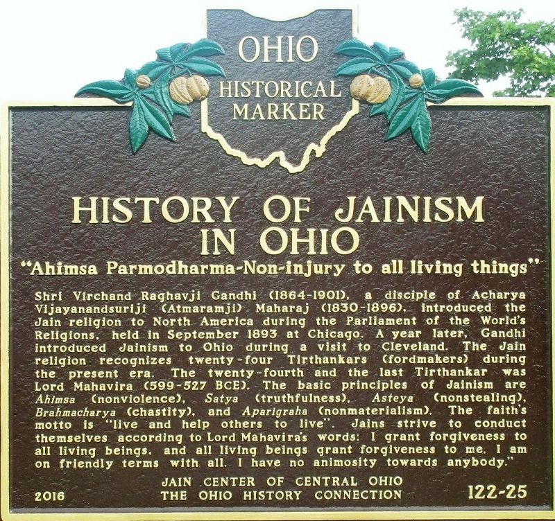
On South Old State Road (County Route 10) at Ashcreek Avenue, on the right when traveling north on South Old State Road.
First Jain Temple in Central Ohio. “Souls render service to one another”. The Jain Center of Central Ohio was established on May 12, 1991. The foundation stone of the Jain temple, the first of its kind in Central Ohio, was laid . . . — — Map (db m105528) HM
First Jain Temple in Ohio
"Souls render service to one another"
The Jain Center of Cincinnati and Dayton was established on April 22, 1979 as a non-profit tax-exempt organization under the laws of the United States and the State of Ohio. . . . — — Map (db m24073) HM
On East State Street west of South 3rd Street, on the right when traveling west.
Ohio in the Civil War. With five army camps in Columbus, Capitol Square was a military crossroads from 1861 to 1865. Ohio troops were mustered, paid, and on some occasions garrisoned at the Statehouse. Three of every five male Ohioans between . . . — — Map (db m9840) HM
On Commercial Avenue SE (Ohio Route 416) at Canal Avenue SE, on the left when traveling south on Commercial Avenue SE.
1825–1913. Seeking an alternative transportation route to distant markets, many farmers and manufacturers in Ohio wanted to connect the Ohio River to Lake Erie with a canal. Beginning in Cleveland the Ohio-Erie Canal ran south, the length of the . . . — — Map (db m293) HM
On South Columbus Street (Ohio Route 13) north of Summit Street, on the right when traveling south.
A Seed of Catholic Education in Ohio. In April 1830 four Dominican sisters from St. Catherine's, Kentucky, founded St. Mary's Academy, the first Catholic school in Perry County. Bishop Edward Fenwick, first Bishop of Ohio, donated a small . . . — — Map (db m11996) HM
First held in Cincinnati in 1850, the Ohio State Fair was organized by the Ohio Board of Agriculture to promote agricultural education and recognize achievements. The second fair was held in Franklinton (now part of Columbus) on the farm of Michael . . . — — Map (db m2043) HM
On Sunbury Road, on the left when traveling south.
Ohio Dominican University Est. 1911 The Dominican Sisters of St. Mary of the Springs founded Ohio Dominican University on this site on October 5, 1911. It was incorporated that year as the Ladies Literary Institute of St. Mary of the Springs, . . . — — Map (db m94624) HM
On Main Street (Ohio Route 235) at College Avenue, on the right when traveling south on Main Street.
Henry Solomon Lehr founded Ohio Northern University in 1871 as the Northwestern Ohio Normal School. Its purpose was to train teachers and to provide higher education to the people of Northwest Ohio. In 1885, the school became Ohio Normal . . . — — Map (db m29025) HM
On East Whittier Street at Blackberry Alley, on the right when traveling west on East Whittier Street. Reported missing.
Site of First Ohio State Home Football Game
In the fall, life for many in Columbus revolves around Ohio State University football, from the first kickoff in September to the last play in November. O.S.U.'s first home game took place at 2:30 . . . — — Map (db m267285) HM
On Riverside Drive at the north bank of the Great Miami River, on the right when traveling north on Riverside Drive.
Welcome to the
Ohio Korean War Memorial
and All Veterans' Memorial Walkway
During the 120th General Assembly regular
session 1993-1994, both houses of the
State of Ohio Legislature unanimously
voted Dayton as the official site
of . . . — — Map (db m29596) WM
On Prairie Street east of North Street ( Route 61), on the right when traveling east.
Historic New Haven, Ohio. New Haven, Ohio. was the mercantile center of southwest Huron County during the first half of the 19th century. Residents described immense wagons, or "land schooners," lined up for miles on the New Haven-Worthington . . . — — Map (db m309232) HM
On North Detroit Avenue south of Benore Road, on the right when traveling north. Reported missing.
Ohio's
Revolutionary
Memorial
Trail
Text on North Side :
Hull-Winchester Marches
1812 • Marches • 1813
- - - - -
Michigan
—
Ohio
State Line
Text on South Side : . . . — — Map (db m93602) HM
On Zane Street (U.S. 40) near Bridge Park, on the right when traveling west. Reported missing.
Ohio County. Formed in 1776 from West Augusta. Named for the river which bears an Indian name meaning “Beautiful River.” Scene of last battle of the Revolution, 1782. Visited by La Salle, Celoron, Gist, Washington, and later explorers.
. . . — — Map (db m9386) HM
On Fremont Pike (U.S. 20) at Bradner Road (County Route 16), on the right when traveling east on Fremont Pike. Reported missing.
Ohio's
Revolutionary
Memorial
Trail
Text on West Side :
Harrison's
March • 1813
- - - - -
25
Miles to
Whittaker's
Reserve
Text on East Side :
Harrison's
March • 1813
- - . . . — — Map (db m93495) HM
On Fremont Pike (U.S. 20) east of Thompson Road, on the right when traveling east. Reported missing.
Ohio's
Revolutionary
Memorial
Trail
Text on West Side :
Harrison's
March • 1813
- - - - -
28
Miles to
Brady's
Island
Text on East Side :
Harrison's
March • 1813
- - - - . . . — — Map (db m93477) HM
On West Boundary Street (Ohio Route 25) near West Front Street ( Route 65), on the left when traveling north. Reported missing.
Ohio's
Revolutionary
Memorial
Trail
Text on South Side :
Harrison-Hull-Tupper
1812 • Marches • 1813
- - - - -
½
Mile to
Fort
Meigs
<————
Text on North . . . — — Map (db m93521) HM
On West Front Street (Ohio Route 65) at West Boundary Street ( Route 25), on the right when traveling west on West Front Street. Reported missing.
Ohio's
Revolutionary
Memorial
Trail
Text on East Side :
Harrison's March - 1813
- - - - -
½
Mile to
Fort
Meigs
Text on West Side :
Harrison's March - 1813
- - - - - . . . — — Map (db m76976) HM
On Pittsburg Landing Road, on the right when traveling west.
(Front):Ohio 65th Infantry commanded by Col. Charles G. Harker Garfield's (20th) Brigade Wood's (6th) Division Army of the Ohio (Back): This regiment arrived on the field at 1.20 p.m., April 7, 1862, advanced to the front near Shiloh . . . — — Map (db m21673) HM
On River Road at South Detroit Avenue, on the right when traveling north on River Road. Reported missing.
Ohio's
Revolutionary
Memorial
Trail
Text on North Side :
Hull-Winchester Marches
1812 • Marches • 1813
- - - - -
5
Miles to
Hull's
Crossing
Text on South Side : . . . — — Map (db m93522) HM
On Dixie Highway (Ohio Route 25) at Ovitt Road (County Route 104), on the left when traveling north on Dixie Highway. Reported missing.
Ohio's
Revolutionary
Memorial
Trail
Text on South Side :
Harrison-Hull-Tupper
1812 • Marches • 1813
- - - - -
6
Miles to
Dudley's
Massacre
Text on North Side : . . . — — Map (db m93456) HM
On Ohio Route 199 at County Route 42, on the left when traveling north on Ohio Route 199. Reported missing.
Ohio's
Revolutionary
Memorial
Trail
Text on South Side :
Harrison's March - 1813
- - - - -
2
Mile to
Crawford's
Burning
Text on North Side :
Harrison's March - 1813
- - - - . . . — — Map (db m93691) HM
On Slocum Avenue, on the right when traveling north.
(Front):29th Ohio Infantry 1st Brig. 2nd Div. 12th Corps. This memorial is erected by the State of Ohio (Left):Gettysburg July 2d and 3d 1863 Engaged 332 - Killed 7 Wounded 31 - 2 mortally Total loss 38 (Back):Principal . . . — — Map (db m13947) HM WM
On S. Sandusky Avenue (Ohio Route 53) at E. Wyandot Avenue (U.S. 30), on the right when traveling north on S. Sandusky Avenue. Reported permanently removed.
On Pittsburg Landing Road, on the right when traveling west.
(Front):Ohio 1 - 2 - 3 Battalions 5th Cavalry commanded by Col. Wm. H.H. Taylor 1st and 2d Battalions. Hurlbut's (4th) Division 3d Battalion. L. Wallace's (3d) Division Army of the Tennessee (Back): 1st and 2d Battalions were in . . . — — Map (db m21672) HM
On Main Cross Street (Ohio Route 12) at Cory Street, on the right when traveling west on Main Cross Street.
Side A: The Ohio Oil Company-Marathon Oil Company
Site of the first Findlay Field Office for what was to become a world-wide oil company, formerly locally owned and operated.
1887: The Ohio Oil Company was incorporated by five independent . . . — — Map (db m29180) HM
On South Green Drive 0.1 miles east of Richland Avenue (U.S. 50), on the right when traveling east.
Ohio University’s Peden Stadium is the oldest of the Mid-American Conference stadiums and one of the oldest of its type in the country. It was dedicated in 1929 with a victory over Miami University. The stadium served as housing for the influx of . . . — — Map (db m42162) HM
Fawcettstown, later to become East Liverpool, marked the first Ohio community to be encountered by early river travelers as they headed toward new challenges and new lives in the expanding nation. Indian canoes, flatboats, and steamboats carried . . . — — Map (db m49713) HM
Built in 1910, the old Ohio Union was the first student union building constructed on a public university campus and the fourth to be built in the United States. Made possible by a direct appropriation from the 77th Ohio General Assembly and private . . . — — Map (db m223483) HM
Near Shingle Road 0.1 miles north of Military Road.
East Side Erected by the State of Ohio in memory of the Ohio troops that were engaged in the Battle of Lookout Mountain, Tennessee Nov. 24, 1863. 1st Brigade 2nd Division 12th Army Corps Col. Charles Candy Col. William R. Creighton 5th . . . — — Map (db m35701) HM
On Tarlton Road at Kingston Pike, on the left when traveling east on Tarlton Road.
90th Ohio Volunteer Infantry. Across the road was the site of Camp Circleville, where members of the 90th and 114th Ohio Volunteer Infantry (O.V.I.) were mustered into service during the Civil War. Pickaway Township farmer Jacob Ludwig donated . . . — — Map (db m13642) HM
On Howard Avenue 0.5 miles east of Carlisle Road (Pennsylvania Highway 34), on the right when traveling east.
(Front):107th Ohio Infantry 2nd Brigade 1st Division 11th Corps This memorial is dedicated by the surviving members of the regiment to their fallen comrades Ohio's Token of Gratitude (Back):The 107th Ohio Infantry left Emmittsburg . . . — — Map (db m61172) HM WM
On Geary Avenue at Slocum Avenue, on the left when traveling north on Geary Avenue.
(Front):Boy's Keep the Colors Up 5th Ohio Infantry 1st Brigade 2nd Division 12th Corps Erected by the State of Ohio (Right):5th Ohio Infantry ——— Gettysburg July 1.2.3. 1863 ——— Present for duty . . . — — Map (db m13858) HM WM
Near North Water Street south of 2nd Street, on the left when traveling north.
From its starting point at the confluence of the Allegheny and Monongahela rivers in Pittsburgh, Pennsylvania, the Ohio River flows 981 miles in a southwesterly direction to Cairo, Illinois, where it joins the Mississippi River. Henderson, Kentucky, . . . — — Map (db m121678) HM
On River Road 0.1 miles north of East John Street, on the right when traveling south.
Here, on May 5, 1813, Colonel Dudley's troops spiked the British artillery besieging Fort Meigs; but, in the enthusiasm of victory they were led into an ambush where over 600 were lost. — — Map (db m18774) HM
Near Ohio River Scenic Byway (Ohio Route 124) south of New Portland Road, on the right when traveling south.
After thirty-eight days of raiding for supplies,
damaging bridges and rail lines, and drawing
the pursuit of Union troops, Morgan's men arrived
here on the evening of July 18, 1863. His objective
was to reach the Buffington Island ford . . . — — Map (db m108335) HM
On Wendy Lane at 2nd Street ( Route 335), on the right when traveling south on Wendy Lane.
The Ohio and Erie Canal, built between 1825 and 1832, had a significant influence on Ohio's economy. In the early 19th century Ohio was largely rural and dependent on subsistence agriculture as the primary business. The canal, which cost nearly . . . — — Map (db m25371) HM
Near Milan Road (U.S. 20) east of Dewitt Avenue (County Route 92), on the right when traveling east.
Following the Civil War, many of Ohio's disabled and wounded veterans found inadequate provisions for their long-term needs. In response, the Grand Army of the Republic's Department of Ohio lobbied for a state-operated veterans' home. In 1886 . . . — — Map (db m79101) HM
On Union Street at Court Street, on the right when traveling east on Union Street.
[Marker front]
Manasseh Cutler, Rufus Putnam, Winthrop Sargeant, and Benjamin Tupper of the Ohio Company conceived Ohio University, which was encouraged by the Ordinance of 1787 and the Northwest Territorial Legislature in 1799, . . . — — Map (db m15564) HM
On Howard Avenue 0.2 miles north of Old Harrisburg Road (Business U.S. 15), on the right when traveling east.
(Front):25th and 75th Ohio Infantry 2nd Brigade 1st Division 11th Corps This monument marks the left flank of the 25th and the right flank of the 75th Ohio Infantry, July 1, 1863. This memorial is erected by the State of Ohio . . . — — Map (db m11335) HM WM
In 1897, a farm boy investigating the disappearance of water into a sinkhole in a nearby field discovered this system of subterranean passageways. Digging down a few feet, he found an opening to a cave that had begun forming perhaps several . . . — — Map (db m198028) HM
On Milan Road (U.S. 250) east of Dewitt Avenue (County Route 92), on the right when traveling east.
Following the Civil War, many of Ohio's disabled and wounded veterans found inadequate provisions for their long-term needs. In response, the Grand Army of the Republic's Department of Ohio lobbied for a state-operated veterans' home. In 1886 . . . — — Map (db m79102) HM
On S. Defiance Street (Ohio Route 66) south of Stryker Street ( Route 2), on the left when traveling south.
(Side One)
Henry Simon Winzeler, founder of The Ohio Art Company, was born in 1876 in the Winzeler family home just north of this site in Burlington. As a young man, he opened a dental practice in 1900 in the Murbach Building in Archbold . . . — — Map (db m68979) HM
On University Terrace 0.1 miles south of East Union Street, on the left when traveling north.
Site of first Ohio University
building erected in 1807
Here Hon. Thomas Ewing
was graduated in 1815
One of the first two graduates — — Map (db m42164) HM
Near Congressman Ralph Regula Towpath Trail 1.3 miles east of Cherry Street West ( Route 93), on the right when traveling east.
Sounds of boat horns and brawling packet crews resounded for many years at this lock and 142 others on the Ohio and Erie Canal. The canal was a 308-mile water toll road built between 1825 and 1832 from Lake Erie at Cleveland to the Ohio River at . . . — — Map (db m246581) HM
On Williams Road at Gerlaugh Drive, on the left when traveling east on Williams Road.
The Ohio General Assembly established the Ohio Agricultural
Experiment Station in 1882. From its inception until 1892, the
Station occupied 17 acres on the Columbus campus of The Ohio
State University before relocating to 470 acres in Wayne . . . — — Map (db m131935) HM
On Second Street at St. Clair Street, on the right when traveling south on Second Street.
The Northwest Ordinance, 1787. Following the establishment of the public land system in 1785, the Continental Congress appointed a committee, chaired by James Monroe, to establish government in the new territory north and west of the Ohio . . . — — Map (db m20653) HM
On South High Street at Church Street, on the right when traveling north on South High Street.
On December 30, 1847, six educators met at the Summit County Courthouse to organize the first convention of the Ohio State Teachers' Association, now known as the Ohio Education Association (OEA). The organizers Josiah Hurty (Richland County), . . . — — Map (db m299758) HM
Near Taneytown Road (State Highway 134), on the right when traveling north.
(Front):Huntington's Battery H 1st Ohio Light Artillery 3rd Volunteer Brigade Artillery Reserve July 2d and 3d 1863. Erected by the State of Ohio (Back):Battery H 1st Ohio Light Artillery Organized at Camp Dennison, Ohio, November . . . — — Map (db m16811) HM WM
On Slocum Avenue at Williams Avenue, on the right when traveling north on Slocum Avenue.
(Front):7th Ohio Infantry 1st Brigade 2d Division 12th Corps July 1, 2, 3 1863 (Left):Dulce et Decorum est Pro Patria Mori 7th Ohio Infantry ————Arrived near Little Round Top evening of July 1 on July 2, held . . . — — Map (db m13943) HM WM
On Parkwood Avenue at Maplewood Alley, on the right when traveling north on Parkwood Avenue.
The Ohio Baptist General Association (OBGA) acquired 48 Parkwood Avenue in 1954 and used the former residence as its headquarters until 1996. Formed in 1896, the Association includes more than forty African American churches, many formed prior to . . . — — Map (db m247605) HM
On South Crest Road 0.1 miles south of Ridge Road, on the right when traveling south.
The preliminary movements of both armies for position occurred the 18th September; the battle was the 19th and 20th; the army was established at Rossville the night of the 20th, and occupied Chattanooga the morning of the 22d.
Rosecrans the . . . — — Map (db m38683) HM
On East 11th Avenue at Essex Avenue, on the right when traveling west on East 11th Avenue.
The Division of Natural Areas and Preserves, in partnership with the Ohio Biological Survey, is celebrating Ohio's unique role in America's westward expansion by highlighting the natural heritage of the region in the 18th century. Updating the 1966 . . . — — Map (db m280893) HM
The Ohio Agricultural and Mechanical College grew out of the Cannon Act of March 22, 1870. “But let it be started,” Governor Rutherford B. Hayes told the Legislature in 1873, “with the intention of making it a great State University.” The little . . . — — Map (db m16944) HM
On South Crest Road 0.1 miles Ridge Road, on the right when traveling south.
3d Ohio Cavalry.
Long's Brig., Crook's Div., Stanley's Corps.
Lieut. Col. Charles B. Seidel.
Nov. 25, 1863.
Crossing the Tennessee in the rear of Gen. Sherman's column on the 24th, the regiment advanced with . . . — — Map (db m38667) HM
On Ohio Route 109 at Route 120, on the left when traveling north on Ohio Route 109.
The Ohio Michigan Boundary War. The Northwest Ordinance of 1787 defined the boundary of the northern and southern tier of states to be carved out of the Northwest Territory, as a line drawn east from the southernmost tip of Lake Michigan . . . — — Map (db m21009) HM
On East 11th Avenue at Essex Avenue, on the right when traveling north on East 11th Avenue.
A geologic cross section depicts the distribution of rock layers in Ohio as being like the layers of a cake. This cross section traverses from the Ohio-West Virginia boundary at Belpre, Ohio, to Bellefontaine, then to the Michigan-Indiana-Ohio . . . — — Map (db m280879) HM
On Main Street south of 4th Street (U.S. 50), on the left when traveling south.
Shoals was the location of the connecting point of the main east-west railroad line, which was laid westward from Cincinnati, Ohio by the Ohio and Mississippi Railroad Company and eastward from St. Louis, Missouri by the Baltimore and Ohio Railroad . . . — — Map (db m180290) HM
On Baltimore Pike (State Highway 97), on the right when traveling north.
(Front):4th Ohio Infantry. 1st Brigade, 3rd Division, 2nd Corps. Carroll's Brigade. Ohio's Tribute. (Left):On the evening of July 2, 1863. Carroll's Brigade was sent from its position with the 2nd Corps to re-enforce this position of . . . — — Map (db m16945) HM
On Steinwehr Avenue (Business U.S. 15) at Long Lane, on the left when traveling north on Steinwehr Avenue.
(Front Inscription):8th Ohio Infantry, Carroll's Brig. 3d Div. 2d Corps. July 2,3, 1863. (Left Side Inscription): The 8th Ohio Infantry under Lt. Col. Franklin Sawyer took this position at 4 p.m. July 2 after a brisk skirmish and held . . . — — Map (db m12190) HM
On Steinwehr Avenue (Business U.S. 15) at Hancock Avenue, on the right when traveling north on Steinwehr Avenue.
(Front): Companies G and I, 4th Ohio Infantry, 1st Brigade, 3d Division, 2d Corps, July 2, 1863. (Left): At 3 p.m., July 2, 1863, while the regiment was lying on Cemetery Ridge, Companies G and I, 4th Ohio Infantry, detached under . . . — — Map (db m12189) HM
On Taneytown Road (Route 134) at Pleasonton Avenue, on the right when traveling south on Taneytown Road.
(Front):Sixth Ohio Cavalry 2 Brigade 2 Division Cavalry Corps Erected by the State of Ohio (Left):The Sixth Ohio Cavalryserved during the Gettysburg Campaign with Huey's Brigade, taking part in several severe engagements. During the . . . — — Map (db m15975) HM WM
On Fred Taylor Drive at Borror Dr., on the left when traveling north on Fred Taylor Drive.
A.B. Graham and the 4-H Movement. In 1902, Albert Belmont Graham (1868-1960), a school teacher and superintendent, established the Boys and Girls Agricultural Experiment Club in Springfield, Ohio. Graham believed in learning by doing, a concept . . . — — Map (db m94110) HM
On MUOT Boulevard north of Glendale Avenue, on the right when traveling north.
State interest in medical education for northwest Ohio became a reality when the Medical College of Ohio at Toledo was established in December, 1964. Located initially at South Detroit and Arlington on Lucas County property, MCO moved to the present . . . — — Map (db m94749) HM
Rail transportation in the United States began in Baltimore, Maryland on July 4, 1828, when Charles Carroll, the only living signer of the Declaration of Independence, laid the cornerstone of the Baltimore and Ohio Railroad.
On the same day . . . — — Map (db m12060) HM
On West Front Street at Pearl Street, on the right when traveling west on West Front Street.
In 1784, the state of Virginia ceded all of its Northwest Territory
to the federal government except for this tract to satisfy the
land bounties owed to its Revolutionary War soldiers. The Virginia
Military District extended from the Scioto River . . . — — Map (db m136532) HM
On Lakeside Avenue at East 6th Street on Lakeside Avenue.
Following the national merger of the American Federation of Labor (AFL) and the Congress of Industrial Organizations (CIO) in 1955, more than 2,000 labor delegates representing one million union members convened at the Cleveland Public Auditorium . . . — — Map (db m17953) HM
On Main Street (U.S. 40) east of 4th Street, on the left when traveling east.
In 1809 the citizens of Zanesville erected a building on this site which served as the capitol of Ohio from October 1, 1810, until May 1, 1812. The 9th and 10th sessions of the Ohio General Assembly met here before returning to Chillicothe in May . . . — — Map (db m275) HM
On Howard Avenue 0.1 miles east of Carlisle Road (Pennsylvania Highway 34), on the right when traveling east.
(Front): The 82d Ohio Infantry Arriving from Emmittsburg at Noon July 1, 1863. Moved rapidly to the support of Dilger's Battery near the Carlisle Road. At 3 p.m. changed front to the right and advanced to a position 125 yards in front of . . . — — Map (db m11171) HM WM
Near Pickerington Road Northwest (County Road 20) south of Broad Street Northwest, on the right when traveling south. Reported permanently removed.
Ohio's 1000-mile network of navigable canals, constructed between 1825 and 1847, provided a system of economical transportation where none had previously existed. The canals opened many markets for its agriculture and industrial products, and . . . — — Map (db m271030) HM
On West Main Street 0.1 miles west of South Union Avenue ( Route 183), on the right when traveling west.
In 1866, Alliance physician, amateur horticulturalist, and politician Dr. Levi Lamborn propagated the scarlet carnation from French seedlings in greenhouses at this site. Opposing William McKinley for the 18th Congressional District in 1876, . . . — — Map (db m78945) HM
[Side A:]
Born in Massachusetts in 1805, Sala Bosworth spent all but nineteen years of his eighty-five years in Washington County. After studying at the Philadelphia Academy of Fine Arts, he returned to the county to paint many full size . . . — — Map (db m20127) HM
On Fremont-Tiffin Road (Ohio Route 53) at Township Road 1020 on Fremont-Tiffin Road.
Ohio
Revolutionary
Memorial
Trail
Text on South Side :
Harrison • Shelby
Marches • 1813
- - - - -
12
Miles to
Brady's
Island
Text on North Side :
Harrison • Shelby
Marches . . . — — Map (db m20577) HM
On Main Street (U.S. 40) west of Broadway Street, on the right when traveling west.
Near here, at the forks
of the Mad River, in 1799
Simon Kenton and other
Kentuckians erected the
first American Stockade
in the Mad River Valley. — — Map (db m137376) HM
Near East Pike National Road (U.S. 40) at Zane Grey Road (County Route 199).
The Act of Congress in 1806, which authorized the construction of the National Road, required that mile markers be placed at regular intervals. These reference points reassured travelers that they were following the correct route. They also . . . — — Map (db m205520) HM
On North Main Street (Ohio Route 66) at Elm Street ( Route 362), on the right when traveling south on North Main Street. Reported missing.
Here, at the headwaters of the Miami, St. Mary’s and Auglaize Rivers, was the only land travel necessary in early days between the Lakes and the Ohio River. — — Map (db m249992) HM
On North Crest Road north of Crest Terrace Drive, on the left when traveling north.
14th Ohio Infantry.
Phelp's Brig., Baird's Div., 14 Corps.
Lieut. Col. Henry D. Kingsbury.
Nov. 25, 1863.
On the morning of the 25th, after marching to Tunnel Hill to support Gen. Sherman, the Division . . . — — Map (db m44578) HM
On Carmack Road 0.2 miles north of West Lane Avenue, on the right when traveling north.
The Ohio General Assembly established the Ohio Agricultural Experiment Station in 1882. From its inception until 1892, the Station occupied 17 acres on the Columbus campus of The Ohio State University before relocating to 470 acres in Wayne County. . . . — — Map (db m46136) HM
On Route 245 at Township Road 47, on the right when traveling east on Route 245. Reported missing.
Here was fought the first of the major engagements of Logan’s 1786 campaign, in which eight Shawnee towns were destroyed and Chief Moluntha killed. Kenton here ran the gantlet in 1778. — — Map (db m136689) HM
On Corinth-Pittsburg Landing Road, on the right when traveling west.
(Front):Ohio 1st Infantry commanded by Col. B.F. Smith Rousseau's (4th) Brigade McCook's (2d) Division Army of the Ohio (Back): This Regiment was engaged here about 10 a.m., April 7, 1862. Its loss was 2 men killed, 2 officers and 45 . . . — — Map (db m43247) HM
On Columbus Street (U.S. 62) near Main Street ( Route 125), on the right when traveling south.
Ohio
Revolutionary
Memorial
Trail
$50 Fine
or
10 days
imprison-
ment or
both for
defacing
this
marker
Ohio State
General Code
Section 12489 — — Map (db m137356) HM
Near West Canal Street (Ohio Route 183), on the right when traveling east.
Side A
The Great Trail
Gateway to the Ohio Country
The ancient trail that passed near this spot was the major overland route entering the Ohio Country from the east through the 1700s. Also known as the Tuscarawas Path, the . . . — — Map (db m80715) HM
Side A:
The hills before you were inspiration for the design of The Great Seal of the State of Ohio. The seal, first depicted in 1803, was often reconfigured until the present image was sanctioned by the Ohio General Assembly in 1967 and . . . — — Map (db m28639) HM
On West 2nd Street at Washington Avenue, on the right when traveling east on West 2nd Street.
Built by General Wm. H. Harrison in Oct. 1812 and named for General Winchester.
For a time it was the only defensive work against the British and Indians in Northwestern Ohio. — — Map (db m18717) HM
On Wainwright Avenue, on the left when traveling north.
(Front):Ohio Honors Her brave sons 25th & 75th Ohio Infantry 2nd Brigade, 1st Division, 11th Corps This memorial is erected by the State of Ohio (Left):After a Severe Battle In the open fields beyond Gettysburg on July 1, 1863, the . . . — — Map (db m17154) HM WM
On Poe Road south of Lafayette Road, on the right when traveling south.
Inscription on stone monument:
14th Ohio Infantry
2nd Brigade, 3rd Division, 14th Army Corps.
Text on bronze plaque:
This regiment, Lieutenant Colonel Henry D. Kingsbury commanding, engaged the enemy . . . — — Map (db m65612) HM WM
On West Main Street (U.S. 40) at South Market Street, on the left when traveling east on West Main Street.
Belmont County. On September 7, 1801, Belmont County became the ninth county in what became the State of Ohio. On April 1, 1803, the state’s first General Assembly appointed a commission to determine if it was necessary to move the county . . . — — Map (db m214486) HM
On South Broadway Street (Ohio Route 49) at West Main Street, on the right when traveling south on South Broadway Street.
Site of
Fort Greene-Ville
»»««
The largest pioneer fort
in Ohio, built in 1793, by
General Anthony Wayne.
Here, August 5, 1795, the
Treaty was signed by which
much of present Ohio was
opened to White . . . — — Map (db m19878) HM
12294 entries matched your criteria. The first 100 are listed above. Next 100 ⊳
Thin black lines indicate changes in relevance. Between each pair of lines entries are ordered geographically but all have the same relevance.
* Inflectional forms of words are their plurals, singulars, and possessives as well as gramatical tenses and similar variations.