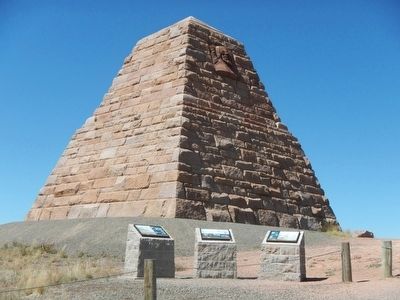
On Monument Road near Hermosa Road, on the right when traveling south.
Commissioned by the Union Pacific Railroad, the Ames Monument is a memorial to the Ames brothers, Oakes and Oliver, for their contributions to the building of the Transcontinental Railroad. Their strong support, drive and influence were . . . — — Map (db m89647) HM
Near Interstate 80 at milepost 332, on the left when traveling east.
This area of southeast Wyoming is rich in history, geology and recreational activities. Within a short distance from this point, sites abound of early day events that have shaped the western heritage of this area, including the Arapaho and . . . — — Map (db m68052) HM
On Monument Road near Hermosa Road, on the right when traveling south.
At first glance, the Ames Monument may seem out of place on this high, wind-swept setting. If you step back and view the Monument from a distance, you will notice its design and shape mimic the surrounding features of the mountain landscape. The . . . — — Map (db m89645) HM
Near Interstate 80 at milepost 332, on the left when traveling east. Reported missing.
The Sherman Mountains are erosional remnants rising above the general level of the surface of the Laramie Range. The flat topped characteristic of the range resulted from beveling during an ancient erosion cycle. Bedrock here is granite, a . . . — — Map (db m287129)
Completed in 1882 at a cost of $65,000. this monolithic, 60-foot high granite pyramid was built by the Union Pacific Railroad Company. It stands on the highest elevation (8,247 feet) of the original transcontinental route. Until 1901, when the . . . — — Map (db m308142) HM
On Interstate 80 Service Road (Local Route 80) near Warren Road, on the right when traveling west.
The granite rocks to the west are more than a billion years old (Pre-Cambrian in age). The sedimentary rocks to the east are some 10 million years old (Late Miocene in age). After the mountains were elevated, some 20,000 feet of rocks were eroded . . . — — Map (db m92157) HM
On Monument Road near Hermosa Road, on the right when traveling south.
Construction of the Transcontinental Railroad across the United States was one of the most significant historic events of the 1800s. Built almost exclusively with manual labor and hand tools, the cross-country railroad took only four years to . . . — — Map (db m89646) HM
This tree was growing out of a crevice in the rock when the Union Pacific Railroad built its original main line fifty feet south of this rock in 1868.
The fence and cable were provided by the Union Pacific Railroad Co. at the request of the . . . — — Map (db m95273) HM
This small pine tree that seems to be growing out of solid rock has fascinated travelers since the first train rolled past on the Union Pacific Railroad. It is said that the builders of the original railroad diverted the tracks slightly to pass by . . . — — Map (db m62159) HM
On Hansen's Road at State Highway 10, on the left when traveling south on Hansen's Road.
The architecture of the Woods Landing Dance Hall reflects the Scandinavian heritage of this area. Typical of Scandinavian construction, this log hall exhibits peeled and rounded logs with stepped and notched corners. Chinking was not necessary . . . — — Map (db m153399) HM
On North 2nd Street near East University Avenue, on the left when traveling north.
Built in 1869 for the Methodist Episcopal Church, this edifice is likely the oldest church building in Wyoming.
It originally was located across the street where the Elks Lodge now stands. — — Map (db m76783) HM
On East Ivinson Avenue east of South 1st Street, on the left when traveling east.
In the late 1800's, the saloons, dance halls and alleys of Laramie were packed
with a cast of colorful women who entertained men for a living. Meet 5 of
these women and hear about their lives. Make sure to see all 16 locations on
the Legends of . . . — — Map (db m280731) HM
On Interstate 80 at Wyoming Highway 210 on Interstate 80.
This monument commemorates the sesquicentennial of Lincoln's birth by the State of Wyoming in 1959 Charles W. Jeffrey, M.D., Rawlins - Wyo. Donor Robert I. Russin, Sculptor — — Map (db m47144) HM
On Grand Avenue near 17th Street, on the right when traveling west.
This bronze sculpture captures the moment when Chief Washakie first raises his lance challenging Crow Chief Big Robber to a duel.
The Battle of Crowheart Butte was ignited when Crow Chief Big Robber and his braves refused to leave an area . . . — — Map (db m95342) HM
On South 2nd Street north of East Garfield Street, on the right when traveling north.
Wyoming has a pretty remarkable suffrage history. Without a lot of fanfare, Wyoming women stepped up with rights equal to men on all counts because of the impressive Suffrage Act of 1869. Come learn more!
Wyoming Women's History House . . . — — Map (db m280736) HM
On State Highway 230 near County Route 33, on the left when traveling west.
From 1849 through the end of the 19th century, thousands followed the Overland Trail into Wyoming, across the Laramie Plains, to a toll bridge near tree on the Laramie River. The historic crossing of the marshy plains consisted of a corduroy road . . . — — Map (db m89621) HM
On Grand Avenue (Business Interstate 80) near 17th Street, on the right when traveling west.
The history of the American West recognizes Washakie as one of its most remarkable leaders. Revered for statesmanship and respected in battle, he united his people into a significant political and military force. A skilled orator and charismatic . . . — — Map (db m95347) HM
On South 2nd Street north of East Garfield Street, on the right when traveling north.
Laramie women who served first on a jury — March 1870
Amelia Hatcher, Jane Hilton, Mary Mackel, Annie Monehan, Sarah Pease, Eliza Stewart
The first woman bailiff — March 1870
Martha Symons Boies
The first woman voter with full . . . — — Map (db m280749) HM
Near West Garfield Street near Snowy Range Road (Wyoming Highway 130), on the right when traveling west.
In 1875, the inmates of the Wyoming Territorial Prison constructed a dwelling for the warden and guards. The dwelling, worth $3,000, consisted of six rooms - a kitchen, dining room, and four bedrooms. On July 3, 1877, Laramie's local newspaper, . . . — — Map (db m95312) HM
Near West Garfield Street near Snowy Range Road (Wyoming Highway 130), on the left when traveling west.
The 1907 photograph to the left shows, from left to right, the boiler plant (foreground), broom factory, outhouse, blacksmith and candle shop, and kitchen extension.
Before shops were built inside the stockade, inmates worked outside cutting . . . — — Map (db m95327) HM
Near West Garfield Street near Snowy Range Road (Wyoming Highway 130), on the right when traveling west.
On June 24th, 1975, the Laramie Sentinel reported, "An icehouse has been built in the bank a few feet from the prison, and some 60 tons of ice were taken out and stored in it for the use of the prison. This, also done by convict labor, . . . — — Map (db m95314) HM
On West Garfield Street near Snowy Range Road (State Highway 130), on the left when traveling west.
Steam was used to heat the new cellblock and administration wing added to the prison in 1889. Though the boiler was only intended to serve the new addition it heated the entire prison (both cellblocks). Working beyond its capacity, the old boiler . . . — — Map (db m95325) HM
Near West Garfield Street near Snowy Range Road (Route 130), on the left.
The original kitchen was constructed in 1873. The bakery ovens sat directly behind it. The extension to the left of the kitchen was added by 1894 and used for a variety of things: store room, icehouse, guards' dining hall, carpentry shop, and . . . — — Map (db m95330) HM
Near East Ivinson Avenue near 6th Street, on the right when traveling west.
Four plaques are located around a monument locate on the Ivinson Mansion grounds in Laramie, Wyoming.
Laramie Woman's Club, organized in 1898, honors Laramie's "First Ladies" who pioneered civic and political responsibility by women . . . — — Map (db m89657) HM
On U.S. 287 at Cavalryman Ranch Road, on the right when traveling north on U.S. 287.
The emigrant trails across Wyoming were a vital link in the transcontinental migration of an estimated 250,000 Americans in the 19th century, and opened the area to settlers. The Indians resented this intrusion and threatened these . . . — — Map (db m67994) HM
Tall trees, short trees, shrubs, grasses and flowering plants -- mountains, canyons, river bottoms, and prairies -- all intermingle to form the landscape. The greater the variety of landforms and vegetation, the more homes or habitats there are for . . . — — Map (db m47149) HM
On South Second Street at East Custer Street when traveling north on South Second Street.
The first person to cross America
by motorcycle, riding from
San Francisco to New York City
May 16-July 6, 1903
George A. Wyman was the first person to make a transcontinental journey across
America by means of a motorized vehicle. Wyman . . . — — Map (db m287438) HM
Near Interstate 80 at Happy Jack Road (Wyoming Highway 210), on the right when traveling west.
"That there should be a Lincoln Highway across this country is the most important thing"
In memory of Henry B. Joy
The first president of the Lincoln Highway Association
Who saw realized the dream of a continuous improved highway from the . . . — — Map (db m84887) HM
This monument commemorates the Lincoln Highway, America's first transcontinental automobile road, and Henry Bourne Joy, the first president of the Lincoln Highway Association (1913). Joy, also president of the Packard Motor Car Company, is . . . — — Map (db m47145) HM
On South 2nd Street north of East Garfield Street, on the right when traveling north.
This plaza honors the historic women of Laramieband Wyoming and recognizes the state, national and worldwide history they have made through their actions and achievements.
On September 6, 2003 the plaza was dedicated and named for the following . . . — — Map (db m280738) HM
On S. 3rd Street (U.S. 287) north of E. Boswell Drive, on the right when traveling south.
Founded in 1868 upon the arrival of the Union Pacific Railroad, Laramie was named after the fur trader Jacques LaRamie. The first female jurors served here in 1870 after Wyoming Territory in 1869, for the first time in history, gave women full . . . — — Map (db m67993) HM
Near South 1st Street at East Kearney Street, on the left when traveling north. Reported missing.
Founded in 1868 upon the arrival of the Union Pacific Railroad, Laramie was named after the fur trader Jacques LaRamie. The first female jurors served here in 1870 after Wyoming Territory, in 1869, for the first time in history, gave women full . . . — — Map (db m280774) HM
On South 1st Street at Grand Avenue, on the right when traveling north on South 1st Street.
This marker is made up of a dozen plaques embedded in a cement patio and a map of historic Laramie also embedded in patio. As each plaque has the same format, only a few of them have been illustrated.
1810-1820
French Canadian . . . — — Map (db m76849) HM
This area of Albany and Laramie Counties is noted for its rich agricultural history. The forests and rolling hills were home to large sheep and cattle herds from the mid 1800s into the 1900s. After the Civil War, trees harvested from what is now the . . . — — Map (db m47150) HM
On S. Kiowa Street 0.1 miles east of Fort Sanders Road, on the right when traveling east.
This Monument
Marks the Site of
Fort Sanders
Established September 5, 1866
Abandoned May 18, 1882
Named in Honor of
Brigadier General
William P. Sanders
Erected by the
State of Wyoming
and
Jacques Laramie Chapter . . . — — Map (db m67995) HM
On East Ivinson Avenue at South 3rd Street (U.S. 287), on the right when traveling west on East Ivinson Avenue.
Laramie circa 1868: 23 saloons. Not 1 Church.
In 1896, Laramie was in need of a little reform. Constructed from local limestone, St. Matthew's Cathedral was built to tame the unruly masses. And today, it sits as the highest Cathedral in the . . . — — Map (db m280730) HM
On May 25, 2019, this location was dedicated to Steen Gronlund, Citizen Driver. Steen was born in Copenhagen, Denmark, but moved to Canada with his family at age nine. Settling in a small farming community in Saskatchewan, Steen was soon hauling . . . — — Map (db m275912) HM
The first in the west through which a telephone line was run. The first conversation over this line was held in 1882 between Bill Nye at Laramie and Hon. E. E. Warren at Cheyenne. — — Map (db m47148) HM
On Grand Avenue (Business Interstate 80) near 17th Street.
The legendary war-horse of the Nez Perce has a rich history dating as far back as 20,000 years. Detailed images of spotted horses can be found on cave walls in southern France. In Austria, a scabbard dating back to 1000 B.C. was found decorated with . . . — — Map (db m95348) HM
On South 2nd Street near East Garfield Street, on the right when traveling north.
The title “The Franchise” refers to the recognition and bestowal of the right of women to vote under full civil equality with men. In 1869, Wyoming became the first state or territory to grant this right.
This act was inspirational to both . . . — — Map (db m76744) HM
On Snowy Range Road (State Highway 130) near Cactus Hill Road, on the right when traveling west.
The route that later became the Overland Trail was followed in 1825 by William Ashley and members of the Rocky Mountain Fur Company, who entered the Laramie Valley from the south, forded the Medicine Bow River near Elk Mountain, and crossed the . . . — — Map (db m89623) HM
The Purple Heart Medal was originated by General George Washington on August 7, 1782 for distinguished valor and is now awarded only to members of the armed forces of the United States, who have been wounded in combat against an armed . . . — — Map (db m47143) HM
On East Ivinson Avenue at S 8th Street, on the right when traveling east on East Ivinson Avenue.
Built in 1888, this Folk Victorian is accentuated with
clapboard, decorative shingle work, half-timbering,
nine-over-one windows and three porches. It was
originally the home of the vice-president of the
University of Wyoming, John D. Conley, . . . — — Map (db m305422) HM
In remote areas of Albany County, Wyoming, passenger trains carrying mail, payroll monies, and express deliveries were tempting targets for bandits. On June 2, 1899, the Union Pacific Overland Flyer No. 1 was flagged down near Wilcox Station, east . . . — — Map (db m89659) HM
To the north lies Como Bluff - "The Dinosaur Graveyard" - one of the greatest and well known fossil beds of dinosaur remains in the world. There paleontologist of the 19th century discovered and unearthed many excellent fossil specimens of the . . . — — Map (db m89665) HM
On Banzhaf Lane (County Route 67) at U.S. 30, on the left when traveling north on Banzhaf Lane.
In memory of those who
passed this way to win
and hold the West
on the Fort Halleck-
Fort Laramie Road
Frontier town of
Rock Creek 10 miles
north east — — Map (db m89658) HM
This stone marks the place where The Overland Stage Line on its way to the West, June 1862 - 1868, crossed the Colorado-Wyoming boundary line. — — Map (db m89620) HM
On Wyoming Route 34, on the left when traveling west.
Edwin Thomas Thorne
May 20, 1941 - December 29, 2004
Tom Thorne earned a BA in zoology and D.V.M. at Oklahoma State
University. In 1968, he started work as a wildlife veterinarian with
the Wyoming Game and Fish Department. There he . . . — — Map (db m285420) HM
On Wyoming Route 34, on the left when traveling west.
Elizabeth Storm Williams
November 15, 1951 - December 29, 2004
Beth Williams earned her D.V.M. at Purdue University in 1977 and
moved on to Colorado State University for a residency in veterinary
pathology and a Ph.D.
Soon . . . — — Map (db m285421) HM
On Greybull Hwy (U.S. 20 / 16), on the left when traveling west.
No larger than a dog, the eohippus, or dawn horse, first appeared approximately 55 million years ago. It had four toes on its front legs and three on its hind legs. Eohippus remains have been found in Wyoming’s Wind River Basin. Over time, . . . — — Map (db m86912) HM
On Greybull Hwy (U.S. 20 / 16), on the left when traveling west.
This region is totally unfit for either rail or wagon roads and can only be traversed with the greatest of difficulty. - U.S. Army Lieutenant Henry Mayandier, while attempting to map a wagon route across the Big Horn Basin in . . . — — Map (db m86910) HM
On East Main Street at South Mountain View Street, on the left when traveling east on East Main Street.
This statue by artist/sculptor, Steve Wirth, depicts Byron Sessions, survey map case in hand, as he prepares to oversee the construction of the Sidon Canal.
It was the policy of the Church of Jesus Christ of Latter-Day Saints, often . . . — — Map (db m91254) HM
On Alternate U.S. 14A at milepost 35, on the right when traveling east.
Following Mormon settlement of the Salt Lake Valley beginning in 1847, church leaders envisioned colonization of the entire inter-mountain region. In following decades, Mormons emigrated from Utah into Idaho, Arizona and Wyoming. Seeking to . . . — — Map (db m91252) HM
Near South Division Street near 1st Street South, on the right when traveling north.
In 1900 the prophet and president of The Church of Jesus Christ of Later-day Saints, sent settlers to northern Wyoming under direction of Apostle Abraham Owen Woodruff. They wee to establish two communities, Byron and Cowley, and build the Sidon . . . — — Map (db m190065) HM
On South Division Street near Main Street (State Highway 789), on the right when traveling north.
In 1900, Lorenzo Snow, prophet and president of The Church of Jesus Christ of Later-day Saints, sent settlers to northern Wyoming under direction of Apostle Abraham Owen Woodruff. They were to establish two communities, Byron and Cowley, and build . . . — — Map (db m190064) HM
On Road 2 North near Road 3 North, on the left when traveling east.
The Deaver Reservoir equalizing, or regulating reservoir missing word(s) serves water to about 1,800 acres on missing word(s) Frannie Division of the Project. For 75 years, the reservoir provided the domestic water supply for . . . — — Map (db m190068) HM
Douglas Fir Bark BeetleThe Douglas fir bark beetle enters the bark where it introduces a fungi and creates galleries in the phloem – the layer under the bark that transports nutrients from the leaves throughout the tree. The galleries . . . — — Map (db m88169) HM
The prominent hill to the east is known as Sheep
Mountain. It is the surface expression of an upward
fold in the earths crust that geologists refer to as
an anticline. Sheep Mountain is a text book example
of an anticline fold. It is 15 miles . . . — — Map (db m308135) HM
On Dry Medicine Lodge Creek 0.1 miles north of County Road 52, on the left when traveling north.
For at least 10,000 years, the area where Medicine Lodge Creek flows out of the Bighorn Mountains has provided a home for humans.
Discovering Ancient Cultures In 1968, the University of Wyoming began an eight-year archaeological . . . — — Map (db m163208) HM
On Dry Medicine Lodge Creek, on the left when traveling north.
Petroglyphs and pictographs often preserve the only known records created by our human predecessors. The rocks are found at Medicine Lodge, some believe to be as old as 2500 years, has barely wasted the affects of time and weather. Mosaic of . . . — — Map (db m163206) HM
On Alternate Route 14A at milepost 74 near Forest Road 651, on the right when traveling east.
Big Horn Basin in northwest Wyoming is bound on the west by the Beartooth and Absaroka Mountains, on the south are the Wind River and Owl Creek ranges, on the north the Pryor Mountains and on the east are the Big Horns. The Basin is nearly . . . — — Map (db m91289) HM
Near U.S. 14A at milepost 74 near 651, on the left when traveling east.
These two plaques offer brief history of the Bighorn Basin.
Bighorn Basin -- It's Creation
Before you lies the Bighorn Basin, which has its southern end in Wyoming and extends into Montana. Six hundred million years of . . . — — Map (db m91305) HM
Near Forest Road 12 near U.S. 14A, on the left when traveling west.
Several of the prehistoric trails that led through the Big Horn Mountains intersect here. The first people using these trails may have entered the area on the very same path you are now using, as long as 10,000 years ago! Over time, possibly due to . . . — — Map (db m91307) HM
On U.S. 14A at milepost 79 near 130, on the right when traveling west.
The large rocks next to you are granite. These were formed within the earth's crust 1 billion years ago. Their exposure is the result of the eroding forces of wind, water, and ice. This granite contains quartz and resembles the rock containing gold . . . — — Map (db m91320) HM
On East Main Street (U.S. 310) near Montana Avenue, on the right when traveling east.
The Flying Tigers were American boys from 41 of our states, fighter pilots trained in our own Army and Navy, who became members of the new A.V.G. (American Volunteer Group) employed by the government of Generalissimo Chiang Kai-shek to protect the . . . — — Map (db m91260) HM WM
Near Alternate U.S. 14A at milepost 59 near Crystal Creek Road, on the right when traveling south.
Side A
One of the largest cattle operations in the Wyoming Territory, the Mason-Lovell Ranch moved its headquarters here in 1883. At its peak the ranch grazed cattle from Thermopolis, Wyoming to the Crow Reservation in Montana. . . . — — Map (db m91280) HM
On U.S. 14A at milepost 79 near Forest Road 130, on the right when traveling west.
Medicine Mountain to your left, was named for the Medicine Wheel, a stone circle that lies atop a ridge below its summit. Designated a National Historic landmark, this symbol remains a mystery as the builders and purpose of the Medicine Wheel remain . . . — — Map (db m91319) HM
Thousands of stone circles lie scattered over the Northern Plains and Rocky Mountains. What were they used for?
Over 100 of these stone circles are known as Medicine Wheels. The Bighorn Medicine Wheel is probably the most well known and sacred . . . — — Map (db m169029) HM
The white man called it the Medicine Wheel, but to many Native Americans Indians it is, "The Place Where the Eagle Lands." To many people it is a sacred place, and there are few that leave without experiencing something outside the ordinary.
It . . . — — Map (db m169030) HM
Near 12 near U.S. 14A. Reported permanently removed.
"Eventually one gets to the Medicine Wheel to fulfill one's life." -- Old Mouse, Arikara
High in the Big Horn Mountains at nearly 10,000 feet above sea level, lies the Medicine Wheel - a place of worship, a National Historic Site, and an . . . — — Map (db m169026) HM
Raptors are graceful hunters of Bighorn Canyon. The location is ideal home for these birds of prey because of the abundance of food and excellent nesting spots. Watch for these magnificent birds in action. — — Map (db m62158) HM
On Alternate U.S. 14A at milepost 71 near Old U.S. Highway 14A, on the left when traveling east.
Reconstruction of 52 miles of US 14A between Big Horn Lake and Burgess Junction, began with a bridge and causeway at the lake in the mid-60s. The mountain project was described as "one of the most difficult" in the Department's history.
Then, . . . — — Map (db m91285) HM
On East Main Street (U.S. 310) near Montana Avenue, on the right when traveling east.
was developed for the U.S. Army during WWII by the Willys Motor Company. Its tough four-wheel drive made it the first all-terrain vehicle. By 1945 over 500,000 had been delivered to the Army and other branches of the armed forces. The Jeep was also . . . — — Map (db m91259) HM
On West Main Street (U.S. 310) near Alternate U.S. 14A, on the right when traveling east.
In honor of
The Mormon Colonists
of the Big Horn Basin
who, under the leadership of
Abraham O. Woodruff, first camped near this site in May 1900. These pioneers, under many difficulties, established towns, notably Byron, Cowley and . . . — — Map (db m91255) HM
On U.S. 14A at Old U.S. Highway 14A, on the left when traveling east on U.S. 14A.
For many years, the northern most road over Wyoming's Big Horn mountains was commonly referred to as the Dayton-Kane Road. It connected those two towns on opposite sides of the mountain, the latter now just a memory beneath the waters of Big Horn . . . — — Map (db m91284) HM
Near Forest Road 12, 1.7 miles north of Federal Highway 14A, on the left when traveling north.
A National Historic Landmark
Located on Medicine Mountain, the Medicine Wheel is one of North
America's most important and well preserved Native American
sacred landscapes which has played and continues to play an
essential role in the . . . — — Map (db m169033) HM
The earthbound journey begins . . . . . . when a raindrop or snowflake hits the upper slopes of the Big Horn Mountains. It joins other drops and gains momentum seeking the path of least resistance. Say “goodbye” to the drop as it . . . — — Map (db m88182) HM
The hillside below the cliffs is managed as a wildlife winter range. Elk and deer in the Big Horn Mountains live at high elevations during the summer, but move down to the lower areas during the winter. The Forest Service helps maintain this winter . . . — — Map (db m153241) HM
The presence of humans in the Big Horn Basin goes back more than 10,000 years. Evidence suggests that the prehistoric people were nomadic hunters and gatherers. Indians inhabited this area until 1878. In the late 1870s settlers, ranchers, and . . . — — Map (db m88172) HM
The large, granite building blocks of Shell Canyon are an extraordinary 2.5 billion years old. Called basement or bedrock, they form the bottom layer covering the molten material in the earth’s core. At some point, the huge plate of bedrock . . . — — Map (db m88189) HM
The red cliff face to your left flanks Sunlight Mesa. At the top is Elephant Head Rock, so named because of its shape. The triangle-shaped mountain to the right is named Pyramid Peak. To your far right is a prominent rock-topped mountain called . . . — — Map (db m68892) HM
If you are a seeker of waterfalls . . . . . . . mark Shell Falls as unique in terms of waterfall origin. Waterfalls form in three basic ways: 1. Where Hard Meets Soft Falls commonly form where a hard, resistant streambed meets a softer one. . . . — — Map (db m88179) HM
Shell Creek nourishes a rich diversity of flowering plants, which in turn attracts tiny winged visitors. Hummingbirds are noted for their uncanny ability to hover in the air like helicopters. By turning their wings upside-down on the backstroke, . . . — — Map (db m89166) HM
Water is a scarce commodity in the arid west. Wherever streams and rivers flow, you will find the pathways of early exploration and travel, the magnets of human settlement. Shell Creek is no exception. Archaeologists discovered evidence that . . . — — Map (db m88186) HM
Can water really move mountains? Bit by bit, grind of water rippling over rock wears the mountain away. In a more dramatic fashion, run-off from melting snow during May and June creates a massive force capable of muscling huge boulders downstream. . . . — — Map (db m88168) HM
On U.S. 14 1 mile west of Forest Road 17, on the right when traveling west.
In June 1959, a tornado roared over the south rim of the canyon directly before you. Its path was along Granite Creek to your left and through what used to be Granite Creek Campground. One person was killed. The twister ripped up timber and laid it . . . — — Map (db m71500) HM
So, what is an “Oasis” anyway? The dictionary defines it as “a green area in a dry, arid region.” What makes it so green? If you guessed WATER, then you were right. Most of this area gets less than ten . . . — — Map (db m88192) HM
2.5 billion years of geologic history lie exposed in the canyon walls of Shell Creek. Gradual cutting action by Shell Creek eventually exposed the basement granite layer that lies above the earth’s molten core. However, Shell Canyon itself formed . . . — — Map (db m88178) HM
Fire has a number of beneficial effects. It eliminates diseased and dying trees, recycles nutrients back into the soil, and starts the cycle of growth again by allowing sunlight to reach the ground, stimulating the growth of grass. The Forest . . . — — Map (db m88171) HM
By the late 1800s, settlers were already trying to wring a livelihood from the harsh environment in Shell Canyon and the valley below. Average precipitation here is less than ten inches per year and land suitable for cultivated crops is scarce. . . . — — Map (db m131490) HM
Near South Douglas Highway (State Highway 59) near East 8th Street, on the right when traveling south.
Behind every name on these bricks is the story of a man or woman who believed in duty and sacrifice to this great nation. Their stories crisscross the globe and speak of glory, honor and sacrifice of individuals who became part of a greater whole, . . . — — Map (db m306297) HM
Near East Warlow Drive at North Osborne Avenue, on the left when traveling east.
The ditch was prone to flooding during heavy rains. One of the worst floods was in August 1912 when two inches of rain fell in two hours. Gillette Avenue flooded as well as the many businesses and homes in the area. The sidewalks which were made of . . . — — Map (db m306495) HM
Near South Douglas Highway (State Highway 59) at East 8th Street, on the right when traveling south.
When the Burlington & Missouri Railroad laid tracks to this area in August of 1891, the town of Gillette came into existence. The railroad provided local ranchers with the means to transport large herds of livestock to markets in the East. After . . . — — Map (db m306293) HM
On Wyoming Hwy 50 (Wyoming Route 50), on the right when traveling south.
The early 20th century explosion of the automobile into American life highlighted a deplorable lack of surfaced roads. Newly minted drivers discovered the unsuitability of wagon trails for the automobile, and local good roads associations formed to . . . — — Map (db m288650) HM
1491 entries matched your criteria. The first 100 are listed above. Next 100 ⊳