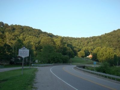
By J. J. Prats, July 14, 2008
Arnoldsburg Skirmish Marker
| On U.S. 33 at Arnoldsburg-Rocksdale Road, on the left when traveling east on U.S. 33. |
| On Arnoldsburg Road (U.S. 33/119) at County Route 33/119, on the right when traveling west on Arnoldsburg Road. |
| On U.S. 33 west of Arnoldsburg-Rocksdale Road (Local Route 18). |
| On U.S. 33 west of Arnoldsburg-Rocksdale Road (Local Route 18), on the right when traveling west. |
| On Little Kanawha Parkway (West Virginia Route 5) 1.3 miles west of the Big Bend Post Office, on the right when traveling east. |
| On Main Street (West Virginia Route 5) at Market Street ( Route 5) when traveling west on Main Street. |
| On Main Street (West Virginia Route 5) at Court Street, on the left when traveling west on Main Street. |
| On Park Place (West Virginia Route 16) at Heritage Drive, on the right when traveling east on Park Place. |
| On Main Street, on the right when traveling north. |
| On Main Street (West Virginia Route 5) at Jarvis Street, on the left when traveling north on Main Street. |
| On Calhoun Highway (West Virginia Route 16) at Milo Road (Local Route 13), on the right when traveling south on Calhoun Highway. |
| Near West Virginia Route 23 at Pike Fork (Local Route 10), on the right when traveling south. |
| On Stone Valley Road near Arnold Creek Road, on the right when traveling east. |
| On Greenbrier Road (County Route 17) 2.2 miles west of Patterson Fork Road (County Route 29) when traveling west. |
| On West Virginia Route 18 at Carter Camp Run Road, on the right when traveling north on West Virginia Route 18. |
| On West Virginia Route 18 at Porto Rico Road, on the right when traveling south on West Virginia Route 18. |
| On Dempsey Road North (West Virginia Route 23) 0.2 miles west of Flanigan Avenue ( Route 23/41), on the left when traveling north. |
| On Greenbrier Road (County Route 17) 0.9 miles west of Patterson Fork Road (County Route 29), on the right when traveling west. |
| On Deepwater Mountain Road South. |
| On North Bend Rail Trail. |
| On Smithton Road at East Main Street, on the right when traveling north on Smithton Road. |
| On High Street, on the right when traveling north. |
| On Old Highway 50 1.5 miles south of U.S. 50, on the left when traveling south. |
| On High Street just east of Chancery Street, on the left when traveling east. |
| On Davis Street (West Virginia Route 18) 0.1 miles north of Howell Street, on the right when traveling south. |
| On West Virginia Route 18 1.7 miles west of Slaughter Run Road (County Route 24), on the right when traveling west. |
| On Davis Street / Old U.S. 50 (West Virginia Route 18) just north of Main Street ( Route 18), on the left when traveling north. Reported missing. |
| On Little Kanawha Parkway 0.1 miles east of Job Run Road (County Road 35/4), on the left when traveling east. |
| On North Court Street just north of Linn Street (County Road 5/3), on the left when traveling north. |
| On Pioneer Way (County Route 5/3) 0.2 miles east of North Court Street, on the right when traveling east. |
| On Lynn Street (County Road 5/3) 0.1 miles north of North Court Street, on the right when traveling south. |
| On West Virginia Route 5 0.1 miles west of Spruce Run (County Route 30), on the left when traveling west. Reported permanently removed. |
| On Little Kanawha Parkway (West Virginia Route 5) just east of 3rd Run Road (County Route 20), on the right when traveling east. |
| On College Street (County Road 119/10) 0.2 miles south of Lynn St (County Road 5/3), on the left when traveling north. |
| On Pioneer Way (County Route 5/3) 0.2 miles east of North Court Street, on the right when traveling east. |
| On Sycamore Road (County Route 12) at Sycamore Run Road (Local Road 12/7), on the left when traveling north on Sycamore Road. |
| On N. Court Street, on the left when traveling north. |
| On East Main Street (U.S. 33) south of South Lewis Street (U.S. 33), on the right when traveling south. |
| On East Main Street west of Court Street, on the left when traveling west. |
| On Linn Street (County Road 5/3) 0.2 miles north of North Court Street, on the right when traveling south. |
| On Lynn Street, on the right when traveling north. |
| On Little Kanawha Parkway (West Virginia Route 5) 0.1 miles east of Job Run Road (Route 35/4), on the right when traveling east. |
| On College St (County Road 119/10) 0.1 miles north of Beallview Drive, on the right when traveling south. |
| On North Lewis Street (U.S. 33) at Factory Road ( Route 5), on the right when traveling east on North Lewis Street. |
| On West Virginia 5. Reported permanently removed. |
| On Little Kanawha Parkway (West Virginia Route 5) just west of Millseat Run Road (Local Road 24/2), on the right when traveling east. |
| On East Main Street just east of Morris Street, on the left when traveling east. |
| On East Main Street at Court Street, on the right when traveling east on East Main Street. |
| On West Virginia Route 47 west of U.S. 33, on the right when traveling east. |
| On Linn Cox Mills Road (West Virginia Route 47) 3.1 miles west of U.S. 119, on the left when traveling west. |
| On Anmoore Road (County Route 58) east of Philippi Pike (County Road 23/9), on the left when traveling west. |
| On Philippi Pike (County Road 23/9) north of Anmoore Road (State Route 58), on the left when traveling north. |
| Near Benedum Drive (West Virginia Route 131) 0.1 miles north of Northwestern Turnpike (U.S. 50), on the right when traveling north. |
| On Northwestern Pike (U.S. 50), on the right when traveling west. |
| Near Water Avenue at Virginia Avenue, on the right when traveling west. |
| On Northwestern Turnpike (U.S. 50) at East Philadelphia Avenue, on the left when traveling east on Northwestern Turnpike. |
| On Interstate 79 4 miles south of Route 279, on the right when traveling south. |
| On Jennings Randolph Highway (Interstate 79 at milepost 122), 1.1 miles north of Johnson Avenue, on the right when traveling north. |
| On Oakdale Avenue at Maple Avenue, on the left when traveling east on Oakdale Avenue. |
| On Forrester Boulevard 0.3 miles north of Benedum Drive ( Route 131), on the right when traveling north. |
| On Meadowbrook Road (West Virginia Route 24). |
| On West Main Street (U.S. 50), on the right when traveling east. |
| Near Benedum Drive (West Virginia Route 131) south of Park Avenue, on the right when traveling north. |
| On Jerry Dove Drive (County Route 13/5) 0.1 miles west of Shinns Run Road (County Route 707), on the right when traveling west. |
| On Despard-Summit Park Road (County Route 24/7) near Bridgeport-Meadowbrook Road (County Route 24). |
| On North Virginia Avenue just north of West Main Street (U.S. 50), on the right when traveling north. |
| On West Main Street at South 3rd Street, on the right when traveling east on West Main Street. |
| On West Pike Street west of South 5th Street, on the right when traveling west. |
| On West Main Street east of South 6th Street, on the right when traveling east. |
| On Milford Street (U.S. 19) at Sampson Street, on the right when traveling north on Milford Street. |
| On West Main Street at South 6th Street, on the left when traveling east on West Main Street. |
| On West Main Street at Court Street, on the right when traveling east on West Main Street. |
| On West Pike Street west of South 6th Street, on the left when traveling west. |
| On West Pike Street west of South 2nd Street, on the left when traveling west. |
| On West Main Street just east of South 3rd Street, on the left when traveling east. |
| On Kiwanis Drive 0.2 miles north of South 2nd Street, on the left when traveling east. |
| On West Main Street east of Sumner Street, on the right when traveling east. |
| Near West Main Street just east of Sumner Street, on the right when traveling east. |
| On West Main Street east of Sumner Street, on the right when traveling east. |
| On West Pike Street west of North 3rd Street, on the right when traveling west. |
| On West Main Street at South 4th Street, on the left when traveling east on West Main Street. |
| On E. B. Saunders Way just south of Lee Avenue, on the right when traveling south. |
| On West Main Street at South 2nd Street, on the right when traveling east on West Main Street. |
| On West Main Street at South 3rd Street, on the right when traveling east on West Main Street. |
| On West Pike Street west of South 2nd Street, on the left when traveling west. |
| On West Main Street just east of South 3rd Street, on the left when traveling east. |
| On West Main Street at South 3rd Street, on the right when traveling west on West Main Street. |
| On South 3rd Street at West Main Street, on the right when traveling south on South 3rd Street. |
| Near South Linden Avenue east of Cherry Street, on the left when traveling east. |
| Near South Linden Avenue east of Cherry Street, on the left when traveling east. |
| On West Main Street just east of South 3rd Street, on the left when traveling east. |
| On West Pike Street (U.S. 19) at Milford Street (U.S. 19), in the median on West Pike Street. |
| On South 3rd Street north of Washington Avenue, on the left when traveling north. |
| On E. B. Saunders Way just south of Lee Avenue, on the right when traveling south. |
| On E. B. Saunders Way just south of Lee Avenue, on the right when traveling south. |
| On West Main Street at South 3rd Street, on the left when traveling east on West Main Street. |
186 entries matched your criteria. The first 100 are listed above.
The final 86 ⊳
