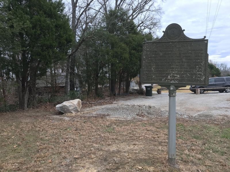
On Reedyville Road (State Road 185) 0.3 miles south of Lock 5 Road, on the left when traveling south.
William Stephens, Sr., gunsmith by trade, came to America from England with his two sons, 1832. They traveled overland, then down the Ohio to the Green River, where they bought 150 acres in 1854. The gunshop operated from 1855-61, when Stephens' two . . . — — Map (db m162250) HM
On Park Street east of Woodbury Loop, on the right when traveling east.
Federal Headquarters for
Green and Barren River Navigation
from 1912 until the 1930s. Today the
building houses exhibits focusing on
the history and culture of the Green River
region, with a special emphasis on
Butler County. — — Map (db m159196) HM
On Lock 4 Road 0.1 miles east of Barren River Road (Kentucky Highway 403), on the left when traveling east.
The career of this naval officer spanned Spanish-American War and World Wars I and II. A native of Butler County, he attended public schools and Ogden College in Bowling Green;
graduated from Annapolis, 1899. Assumed command of USS . . . — — Map (db m159198) HM
On Woodbury Loop (Kentucky Route 403) east of Hines Street, on the left when traveling east.
Capt. Thomas Henry Hines enlisted in the Confederate Army, 1861. With Brig. Gen. John H. Morgan, 1862-63. Captured, July '63, in Ohio with Morgan. Led escape from Federal prison, Nov. '63. Leader of northwest conspiracy '64. Termed most dangerous . . . — — Map (db m123424) HM
On State Highway 1351 at Groce Gibson Road, on the left when traveling south on State Highway 1351.
Side 1:
Residents and students alike held the traditions of the school in high esteem. Two became college presidents: Drs. A. B. Mackey and T. W. Willingham. Others who gave years of service to the community well beyond the school era were Dr. . . . — — Map (db m244686) HM
On Cumberland Street at South Cross Street, on the left when traveling west on Cumberland Street.
Champ Ferguson born here in 1821. Guerrilla leader with Confederate leaning, but attacked supporters of both sides thruout Civil War in southern Ky., Tenn. Over 100 murders ascribed to Ferguson alone. Hunted by both CSA and USA. Taken after end of . . . — — Map (db m136581) HM
Near Clear Fork Road 0.1 miles east of County Road 1150K, on the left when traveling east.
Front
Isaac Denton, Sr., first preacher in region, 1798. He founded the Stockton Valley Church, 1801, and constituted Clear Fork Baptist Church, April 1, 1802; founded Stockton Valley Assn., 1805. Organized first school in area, 1806. . . . — — Map (db m136773) HM
On North Washington Street at Cumberland Street, on the left when traveling north on North Washington Street.
For DeWitt Clinton, 1769-1828. In New York Senate, nine years; U.S. Senate, 1802-03, where he introduced XII Amendment, present method of electing U.S. president, vice president. Mayor, New York, nine years; leader, tax supported school movement. . . . — — Map (db m136583) HM
On Jefferson Street at South Cross Street (Business U.S. 127), on the left when traveling east on Jefferson Street.
Twenty-two Kentucky courthouses were burned during Civil War, nineteen in last fifteen months: twelve by Confederates, eight by guerrillas, two by Union accident. See map on reverse side. The courthouse at Albany was burned by guerrillas late in . . . — — Map (db m136768) HM
Near South Clearfork Road 0.3 miles north of Cedar Knob Road ( Route 969), on the right when traveling north. Reported missing.
Thomas E. Bramlette born near here on Jan. 3, 1817. State legislature in 1841. Appointed by Gov. John Crittenden as the commonwealth's attorney, 1848. Circuit judge, 1856-1860. Accepted Federal Army commission in 1861. Raised and commanded 3rd Ky. . . . — — Map (db m136585) HM
On North Washingtgon Street at Jefferson Street, on the left when traveling north on North Washingtgon Street.
William Wood (1773-1851), native of Virginia, was a founder of Cumberland and a leader in Clinton Co. He represented Cumberland Co. (when Clinton was part of it) in the General Assembly for 23 years. One of the founders of Clear Fork Baptist Church, . . . — — Map (db m136771) HM
On Seventy Six Falls Road (State Road 1062) west of Morris Thomas Road, on the right when traveling north.
Side 1:
Born near here in August 1909. Served 16th dist. in state senate, 1952-1959. In 1954 sponsored both Minimum Foundation Act (school support) and lowering the voting age to 18. In 1958 he promoted the veterans bonus legislation & public . . . — — Map (db m244687) HM
On Banks Street south of Upper River Street, on the right when traveling south.
John Hunt Morgan’s Great Raid into Kentucky, Indiana and Ohio began in Cumberland County, Kentucky. The raid lasted 25 days and covered a thousand miles, making it the longest Confederate raid of the Civil War.
Morgan commanded 2,460 cavalrymen . . . — — Map (db m98884) HM
On Celina Road (Kentucky Route 61) 0.4 miles north of Cold Springs Road, on the right when traveling south.
During late June 1863 Confederate Gen. John Hunt Morgan's scouts and portions of his nine regiments moved into Cumberland County preparing for the Great Raid in Kentucky, Indiana, and Ohio.
The 1st Brigade, numbering 1,450 cavalrymen under Col. . . . — — Map (db m98882) HM
On Courthouse Square at North Main Street, on the left when traveling south on Courthouse Square.
This memorial is dedicated to those Cumberland countians killed in action while serving in the military forces of the United States during armed conflicts. They answered their nation's call and sacrificed their lives that others might live free. . . . — — Map (db m245333) WM
On North Main Street (Kentucky Route 61) at Hill Street, on the left when traveling south on North Main Street.
Established 1798, taken out of Green County. Later, between 1800 and 1860, parts of Wayne, Monroe, Russell, Clinton, Metcalfe were taken from its original territory. First known white men here, 1769. Daniel Boone explored area, 1771. Burkesville, . . . — — Map (db m98889) HM
On Upper River Street east of Veterans Street, on the left when traveling east.
In appreciation for his fifty four years of outstanding service to the community as a physician and as an energetic and generous supporter of many improvements which enhanced the quality of life for citizens of Cumberland County. Some of the major . . . — — Map (db m245359) HM
On North Main Street (Kentucky Route 61) at Hill Street, on the left when traveling south on North Main Street.
Thomas Lincoln made claim for land in Cumberland County in May, 1801. In Jan., 1802 and again in 1804 he was appointed constable. On Sept. 5, 1802, he was commissioned ensign in Cornstalk Militia of Cumberland County. Returned to Washington County. . . . — — Map (db m98887) HM
On South Main Street (Kentucky Route 61) at Upper River Street, on the left when traveling north on South Main Street.
July 2, 1863, CSA Gen. John Hunt Morgan crossed Cumberland River near here, brushing aside Union patrols on north bank. Morgan placed some troops in ambush one mile from here and drove Union forces back to camp at Marrowbone. Morgan crossed Kentucky . . . — — Map (db m98891) HM
On North Main Street (Kentucky Route 61) at Hill Street, on the left when traveling south on North Main Street.
CSA Morgan's Raiders entered Kentucky here July 2, 1863. Union forces skirmished at Burkesville that day, followed by battles at Tebb's Bend July 4 and Lebanon on the 5th. At Brandenburg crossed Ohio River July 8 into Indiana. In northeastern Ohio, . . . — — Map (db m98886) HM
On Norris Branch Road 0.1 miles north of Glasgow Road ( Route 90), on the left when traveling north.
After the initial wave of Morgan's 1st Brigade crossed the Cumberland River, he sent about twenty men to reconnoiter west of Burkesville. The objective was to deflect the attention of the 3,000 Union soldiers camped at Marrowbone, seven miles west, . . . — — Map (db m98894) HM
On Hill Street at North Main Street ( Route 61), on the right when traveling east on Hill Street.
It all began in 1814 when three brothers, John, Philip, and Reuben Alexander opened a store called the "J.P.R. Store." Throughout the 19th century this store, not only sold drugs for man and animal, but sold everything from planks to cuff buttons. . . . — — Map (db m98885) HM
On Courthouse Square at North Main Street, on the left when traveling south on Courthouse Square.
The Coe Family. In 1811, John Coe (1784-1854), arrived in Cumberland County with at least 3 people he enslaved. They grew dark tobacco, cotton, oats, wheat and corn. The plantation thrived because of the talents of Sukey, Patsy Ann, Ezekiel, . . . — — Map (db m244684) HM
On Upper River Street at City Street 1074, on the left when traveling east on Upper River Street.
Cumberland County was organized in 1798 and received its
name from the Cumberland River which flows through the county from end to end. Exploration of the river led to the settlement of its county seat, Burkesville, in 1810. For many years folks . . . — — Map (db m244685) HM
On Glasgow Road (Kentucky Route 90) at Roadside Spur Road, on the left when traveling west on Glasgow Road.
Both Union and Confederate troops used Marrowbone as a camp several times during the Civil War. In mid-February 1863, Federal 1st Kentucky Cavalrymen under Col. Frank Wolford encamped at Marrowbone. During the spring of 1863, detachments of at least . . . — — Map (db m98895) HM
On Nolin Dam Road (Kentucky Route 728), on the right when traveling east.
Nolin River Lake is a multipurpose flood control project operated by the U.S. Army Corps of Engineers. Any run-off which falls in Nolin Lake’s 703 square mile watershed will eventually flow through the dan’s conduit and into Nolin River below the . . . — — Map (db m233348) HM
"All of this offers
exceptional opportunity
for developimg a great
national recreational
park of outstanding
service in the very
heart of our nation's
densest population."
Southern Applachian National Parks Commission
The . . . — — Map (db m107607) HM
On Main Cross Street at Route 259, on the right when traveling north on Main Cross Street.
Established 1828 and named for Jacob Brown, Commanding General of the United States Army, 1821 until death, 1828, age 53 years. Defended New York state frontier against British in War of 1812, engaging them at Ogdensburg, Sackett's Harbor, Chippewa, . . . — — Map (db m233314) HM
On Main Street (Kentucky Route 70/259) at Main Cross Street, on the left when traveling east on Main Street.
Brig. Gen. T. C. Hindman's force, reconnoitering to protect Bowling Green portion of CSA defense line, approached Brownsville on Nov. 20, 1861. They skirmished here with the Union cavalry Col. James S. Jackson, posted at Leitchfield. The Union loss . . . — — Map (db m171802) HM
On Main Cross Street at Washington Street, on the right when traveling north on Main Cross Street.
For Capt. John Edmonson, b. 1764, Va. In War of Revolution a private in company led by father. Battle of King's Mountain, 1782. Came to Ky., 1790. In War of 1812, raised rifle company in Fayette County. Killed at Battle of River Raisin, Jan. 22, . . . — — Map (db m170838) HM
On Main Cross Street at Washington Street, on the right when traveling north on Main Cross Street.
In Honor of Edmonson County Veterans Who Gave Their Lives for Their Country
World War I
Deaths ~ World War I
Edmonson County
April 6, 1917 through
November 11, 1918
Athel Cummings • Estill Durbin • Elzie French • Loren . . . — — Map (db m233343) WM
On Main Street at Jackson Street, on the right when traveling west on Main Street.
This is the only natural entrance to
Mammoth Cave. Over 2,000 years ago
Indians used this opening for shelter,
for burials, and as an avenue to farther
reaches of the cave. According to legend,
the entrance was "discovered” in 1799 . . . — — Map (db m171793) HM
On Main Cross Street at Washington Street, on the right when traveling north on Main Cross Street.
Sgt. Sanders received the Distinguished Service Cross and the French Croix de Guerre with gilt star for bravery in the battle for Hill 204 in the Aisne-Marne Defensive, and other major campaigns in WWI. Following WWI, Pleas served as Edmonson Co. . . . — — Map (db m233344) WM
On Brownsville Road just west of Fairview Church Road, on the right when traveling east.
U. S. Senator from Kentucky, March 1931 until his death Oct. 1939. Born, 1875, on this farm, attended Brownsville schools. Admitted to bar, 1896, practiced here. State Attorney General, 1916-17. Judge Ky. Court of Appeals, 1927-1930. Grand Sire of . . . — — Map (db m171807) HM
During the first 50 years of Mammoth Cave tourism, much of Kentucky was considered the American West. The road leading to Mammoth Cave was sometimes as rugged as the primitive trails within it. In 1859, the Louisville and Nashville Railroad was . . . — — Map (db m79295) HM
On Chalybeate Road at Route 3611, on the right when traveling south on Chalybeate Road.
Chalybeate Springs
Discovered by Dr. William Ford in
the early 1800s, the springs were
famous for their supposed healing
powers. The Chalybeate Springs
Hotel provided dancing, dining
horse racing, golf, tennis, and
fox hunting. Andrew . . . — — Map (db m171223) HM
On Kentucky Route 259 0.1 miles south of Cottonwood Lane, on the left when traveling south.
Bituminous sandstone, better known as rock asphalt, composed of silica sand that is saturated with oil. Chief deposits in Ky. were found in Edmonson Co. along the Nolin River. Primarily used in road construction, it could be applied without heating . . . — — Map (db m170857) HM
On Moutardier Road south of Oakland Hills Road, on the right when traveling south.
Nolin Furnace Also called Baker Furnace after its
ironmaster, John H. Baker,
was built in 1848, a mile north,
by Craddock &. Co. The top of the
stone stack, about 40 ft high
originally, is still visible when
water in the Nolin Reservoir . . . — — Map (db m171787) HM
Near Mammoth Cave Pkwy west of Beaver Dam Chapel Road.
In 1839 African American slaves Stephen Bishop (buried here), Mat Bransford, and Nicholas Bransford, came to Mammoth Cave to work as cave guides. Cave visitors from around the world extolled their exploits as guides and cave explorers. The guides’ . . . — — Map (db m233234) HM
On Kentucky Route 70 0.2 miles west of Joppa Ridge Road, on the right when traveling west.
Life in the Joppa Ridge area centered on community, and its heart was often the Church. Memories were made at weddings, revivals and funerals. Members were empowered by congregational support, and that support was relied upon from generation to . . . — — Map (db m233318) HM
The Mammoth Cave Railroad Company used four 04-2T-type “dummy” engines to pull cars along its branch line. Steam engines work by burning fuel to heat water to produce steam under high pressure.
The pressurized steam is then channeled through a . . . — — Map (db m79296) HM
Near Mammoth Cave Parkway (Kentucky Route 70) 0.6 miles west of Route 255.
Although the house is gone, the stone hearth remains – a silent reminder of the home that once stood here. It is not difficult to imagine a family enjoying the warmth of their fire as the steam engine of the Mammoth Cave Railroad rattled . . . — — Map (db m79294) HM
Prehistoric people were the first to stand beneath this forest canopy and feel the chilly breath coming from a black, gaping hole in the ground.
Local tradition has it that, in the late 1790s, a young pioneer chased a wounded bear into the same . . . — — Map (db m252623) HM
Near Mammoth Cave Parkway (Kentucky Route 70) 0.2 miles west of Route 255.
The Mammoth Cave Railroad didn’t wind through wilderness – once families, communities, and congregations called these hills home. An abandoned chimney, a foundation stone, or even a line of daffodils may mark an old homeplace. Among the most . . . — — Map (db m79292) HM
Near Mammoth Cave Parkway 3 miles north of Route 70.
Through the collective recognition of the community of nations expressed within the principles of the convention concerning protection of the world cultural and natural heritage Mammoth Cave National Park has been designated a World Heritage . . . — — Map (db m154996) HM
On Mammoth Cave Parkway (Kentucky Route 70) 2.4 miles west of Route 225, on the left when traveling west.
Long before the establishment of Mammoth Cave National Park, the town of Glasgow Junction, now Park City, cooperated with the private owners of Mammoth Cave and other caves in the area in sharing this region with travelers. They were connected by . . . — — Map (db m154965) HM
On Brier Creek Road 0.5 miles west of Nolin Church Road, on the left when traveling west.
The Nolin River is named for the early American explorer and Kentucky militia member Benjamin Lynn. Serving under George Rogers Clark during the Revolutionary War, Lynn traveled to Illinois to spy on the British and Indian forces, and also played a . . . — — Map (db m233349) HM
This cemetery, known as 'Old Guide's Cemetery,"
probably began as a slave cemetery. Others buried
here were early visitors to Mammoth Cave. They
share this resting place with cave guide Stephen
Bishop, who died in 1857 and is the only known . . . — — Map (db m252515) HM
Near Mammoth Cave Parkway 0.5 miles west of Beaver Dam Chapel Road.
The Green River linked the nineteenth-century Mammoth Cave community to the rest of the world. Kentucky pioneers found it less expensive and more efficient to transport large loads by Green River than by horse and wagon over rough overland roads. . . . — — Map (db m233237) HM
On Mammoth Cave Parkway 3 miles north of Route 70.
He laid the foundation of the National Park Service, defining and establishing the policies under which its areas shall be developed and conserved unimpaired for future generations. There will never come an end to the good that he has done. — — Map (db m71150) HM
On Mammoth Cave Entrance Road south of Cave City Road, on the right when traveling north.
As you look out across this valley, you stand at the very western reach of central Appalachia. If you continue west beyond this county, you leave behind a vast region of distinct natural and cultural flavor.
Spanish explorers in 1548 gave . . . — — Map (db m285820) HM
Along this stretch of the Mammoth Cave Railroad, passengers looking out their small passenger coach were greeted with views of open fields. Then, the route of the Mammoth Cave Railroad was not through the forest, but through rural farmland.
For . . . — — Map (db m79298) HM
Near Mammoth Cave Entrance Road, on the left when traveling north.
Veterans groups set the American Legion Monument and the American War Mother’s Monument at this spot in the 1920s to commemorate the dead of World War I, a war whose violence, brutality and carnage stunned the world. People called the war “The Great . . . — — Map (db m233312) HM
On Mammoth Cave Entrance Road south of Cave City Road, on the right when traveling north.
You stand at the head of forested Doyel Valley. It has not always looked this way.
Native Americans traveled this way through old-growth forest of oak, hickory and other trees. European settlers found an ancient woodland thick with the bark . . . — — Map (db m285712) HM
On Mammoth Cave Parkway 0.8 miles north of Route 70, on the left when traveling north.
Most of Mammoth Cave National Park’s landscape is an upland plateau dissected by deep, dry valleys. Here, Doyle Valley posed a significant challenge to the Mammoth Cave Railroad.
In 1886 a trestle leveled the grade. Today the park roadway is . . . — — Map (db m79297) HM
On Turnhole Bend Hiking Trail north of Route 70, on the right when traveling west.
Turnhole Bend Spring, 75 feet below, is the third largest spring in Kentucky, draining 345km2 of the surrounding region into Green River. Water flow can range from 100 to 6,000 gallons per second. Much of this water originates from a large area . . . — — Map (db m285845) HM
Near Mammoth Cave Parkway (Kentucky Route 70) 0.5 miles west of Route 255.
Here along the Mammoth Cave Railroad and at the junction of two country roads, John Newton “Newt” France operated a country store in the 1920s. Here also starting in 1922 automobile travelers would have to make a choice. The main county . . . — — Map (db m79293) HM
On Nolin Dam Road (Kentucky Route 728) 0.1 miles north of Ollie Road, on the left when traveling north.
John Swadden Sanders and brothers Joseph, Joshua, and Samuel were among earliest settlers of Forks region, between Nolin and Green Rivers. Sanders family first came to Ky., 1779. John later settled in present-day Edmonson Co., ca. 1804; buried at . . . — — Map (db m233315) HM
On Louisville Road (U.S. 31w) at Chaumont Road, on the right when traveling west on Louisville Road.
One mile west is an archaeological site located about 200 yards southeast of Federal style house built in early 1800s. Variety of stone implements found on this five-acre site indicates long span of occupation. There is evidence of hunting, stone . . . — — Map (db m233316) HM
On S. Depot Street south of Henry Street, on the left when traveling south.
Union Generals from Greensburg.
MAJ. GEN. WM. T. WARD, 1808-1878. Congressman 1851-53. He recruited three regiments in this area. On Sept. 2, 1864 Atlanta surrendered to him. In Sherman’s March to Sea.
BRIG. GEN. E.H. HOBSON, . . . — — Map (db m96865) HM
On Henry Street at Hodges Street, on the right when traveling east on Henry Street.
Edward Henry Hobson was born in Greensburg, Kentucky, on July 11, 1825. He was educated in the common schools of Greensburg and Danville, Kentucky. He worked for his father who was a successful merchant in Greensburg. In 1846 Hobson enlisted for . . . — — Map (db m96862) HM
Edward Henry Hobson was born in Greensburg, Kentucky, on July 11, 1825. He was educated in the common schools of Greensburg and Danville, Kentucky. He worked for his father who was a successful merchant in Greensburg. In 1846 Hobson enlisted for . . . — — Map (db m96925) HM
In honor and memory of those Green Countians who served and died in defense of freedom and liberty.
WWI
Anderson, Jake • Barnett, Marshall • Cook, Eugene • DeWitt Sylvester • Donan, Jack • Goff, Carl E. • Grimsley, John • Grimsley, . . . — — Map (db m96929) WM
Incorporated in 1794, Greensburg, the county seat of Green County, began as Glover’s Station, a wilderness settlement in the Kentucky Territory on the Cumberland Trace, an offshoot of the Wilderness Road. From 1800 to 1840, Greensburg flourished as . . . — — Map (db m96924) HM
Formed from parts of Lincoln and Nelson counties. The last of seven formed during first legislature. Named for Gen. Nathaniel Greene, who, in the Revolutionary War, commanded a unit at Boston, 1776; helped plan defense of New York; fought at . . . — — Map (db m96930) HM
One of the oldest public buildings still standing in Kentucky. Built between 1802-1804 by Robert Ball, Edward Bullock, Thomas Metcalfe, Walter Bullock and Daniel Lisle. Used as a courthouse for 135 years. Jane Todd Crawford Library on second floor. — — Map (db m96927) HM
On Skinhouse Branch Road (State Road 2188) at Long Hunters Camp Road (State Road 767), on the right when traveling south on Skinhouse Branch Road.
Here in 1770, Col. James Knox settled with 22 men from Virginia and Carolina. They explored this section, cured and stored 2300 deer hides and other furs in a skin house. The glowing description of the Kentucky wilderness by the "Long Hunters" to . . . — — Map (db m245360) HM
On North Main Street (State Highway 70) south of West Hodgenville Avenue, on the right when traveling south.
Home of Rev. David Rice, founder of first Presbyterian churches west of Alleghanies, 1784. Born in Va., 1733; moved to Danville, Ky. in 1788 after having founded “Rice’s School,” or Transylvania Seminary near there, 1785. Member, State . . . — — Map (db m121837) HM
On S. Depot Street at Henry Street, on the right when traveling south on S. Depot Street.
Home of Union Gen. Edward Henry Hobson, the captor of Gen. John Hunt Morgan at Buffington Island, Ohio
The Federal style house was originally built for Hobson’s father, Capt. William Hobson, in 1823. The house is a brick . . . — — Map (db m96863) HM
Home of Union Gen. Edward Henry Hobson, the captor of Gen. John Hunt Morgan at Buffington Island, Ohio
The Federal style house was originally built for Hobson’s father, Capt. William Hobson, in 1823. The house is a brick . . . — — Map (db m96928) HM
On Columbia Highway at County Road 1187, on the right when traveling north on Columbia Highway.
This pioneer woman rode a horse from this home sixty four miles to Danville. On Christmas Day 1809 was operated on by Ephraim McDowell, M.D. for an ovarian tumor. Four weeks later she came back after recuperating from the word's first ovariotomy. — — Map (db m244690) HM
On S. Main Street (U.S. 68) south of W. Columbia Avenue, on the right when traveling south.
Birthplace of William H. Herndon, 1818. Family moved to Illinois, 1820. An anti-slavery advocate and partner with Abraham Lincoln in practice of law, 1844-61. Herndon, Mayor of Springfield; State Bank Examiner. After Lincoln’s death, devoted life to . . . — — Map (db m96932) HM
On E. Columbia Avenue (State Highway 417) east of S. Depot Street, on the right when traveling east.
Reuben Creel, Greensburg native, appointed by Lincoln as consul from U.S. to Chihuahua, Mexico, 1863. Served until 1866. His son Enrique C., in turn, served as ambassador from Mexico to U.S., 1907-09. Reuben went to Mexico with Gen. Ward, Greensburg . . . — — Map (db m96866) HM
On S. 2nd Street at W. Court Street, on the right when traveling south on S. 2nd Street.
Graham was born & raised in Green Co. He was headmaster of Greensburg Academy, located at this site, from 1818-1823. In 1826, he moved to New Salem, Il. where Abraham Lincoln attended his school learning grammar and arithmetic. They remained close . . . — — Map (db m124184) HM
On Hodgenville Road (State Highway 61) 0.1 miles south of State Highway 566, on the right when traveling north.
(Side One)
Iron in Green County
Three iron furnaces built along Brush Creek after iron ore was found, 1815. Jacob Holderman and Charles Wilkins built furnace and forge, 1816, 10 miles downstream. Joseph Harrison erected furnace, . . . — — Map (db m96939) HM
On Hudgins Highway (State Highway 569) at Hodgenville Road (State Highway 61), on the right when traveling west on Hudgins Highway.
Three miles west, birthplace of Mentor Graham, 1800-86, “The Man Who Taught Lincoln”. Sixty years a teacher. Green County 1818-26. After Illinois voted down slavery, moved to New Salem, 1826. There, from 1831-37, as tutor and friend, he . . . — — Map (db m124186) HM
On Bacon Creek Road (State Highway 728) east of North Dixie Highway (U.S. 31W), on the left when traveling east.
In 1788, William Smuthers, Gilbert LeClerc and his wife, pioneers, were on their way to settle the land they bought, which later became the site of Munfordville. The men were killed by Indians, about 4 mi. SE of here. The deed taken as part of the . . . — — Map (db m39936) HM
On North Dixie Highway (U.S. 31W) at Morgans Raiders Avenue, on the right when traveling south on North Dixie Highway.
The Louisville & Nashville RR, completed in 1859 and running north and south, was used by both Union & Confederate armies. Bridge spans on the line were particularly targeted by raiders. The L&N bridge crossing Bacon Creek was destroyed several . . . — — Map (db m174379) HM
On North Dixie Highway (U.S. 31W), on the right when traveling north.
The L & N R.R. bridge near here, a main USA supply line between Louisville and Bowling Green, was destroyed by Confederate troops in late 1861. Before repairs were complete, Morgan's Raiders burned it Dec. 5, 1861. This act brought Morgan's daring . . . — — Map (db m38507) HM
On North Dixie Highway (U.S. 31W) at Morgan's Raiders Avenue, on the right when traveling north on North Dixie Highway.
The unlucky L&N Railroad trestle over Bacon Creek received harsh treatment at the hands of Confederate raider John Hunt Morgan not once, but twice during the Civil War. The first destruction, in August 1861, was the first of many attacks Morgan . . . — — Map (db m39938) HM
On Hammonsville Road (State Highway 357) at Hammonsville-Jonesville Road (State Highway 2785), on the right when traveling north on Hammonsville Road.
Sergeant Joseph Timberlake, born in Va., 1752: buried here, 1841. Revolutionary soldier. One of the members of General Washington's body guard. All were chosen as being "sober, young, active and well built, men of good character that possess pride . . . — — Map (db m182935) HM
Discovered 1799 by Martha A. Woodson on land granted by the first Congress to Colonel Charles A. Woodson as a part of the Lands South of Green River, reserved for Veterans of the American Revolutionary War.
Kentucky Caverns served as a source . . . — — Map (db m201441) HM
On N. Dixie St. (U.S. 31W) at State Highway 218, on the right when traveling west on N. Dixie St..
Shot down a lead plane of first invading flight of the Korean War, June 27, 1950. Four of enemy's nine fighter planes destroyed. Lt. Moran was killed in action 40 days later, Aug. 7, 1950. Member of the 58th Fighter (AW) Squadron. Born in Horse Cave . . . — — Map (db m41475) HM
On Old Lexington Road at South Jackson Highway (U.S. 31E), on the right when traveling west on Old Lexington Road.
Politician and outstanding orator who came to Barren Co. at an early age. He was born in Virginia in 1795, and is buried near here. A surveyor and teacher, who for many years represented Barren Co. in the Kentucky Legislature. Town of Hardyville in . . . — — Map (db m244677) HM
Near Old Dixie Road 0.1 miles north of J. Harper Road, on the left when traveling north.
Unknown
Soldier C.S.A.
Was a Member
Of Gen.
Clay Anderson
Division
11th Louisiana
Killed
Sept. 9, 1862
Erected 1934
by
Sam Lively — — Map (db m96729) HM WM
On U.S. 31E at Powder Mill Road ( Highway 569), on the right when traveling north on U.S. 31E.
Two miles east on Lynn Camp Creek John Courts built, 1811-12, first commercial gunpowder mill in the State of Kentucky. Located near two large springs that furnished power to grind the charcoal made on site. Mixed with saltpeter and sulphur, finer . . . — — Map (db m96818) HM
On U.S. 31E at Aetna Furnace Highway ( Highway 936), on the right when traveling north on U.S. 31E.
Built in 1816, first iron furnace in western half of Kentucky. Salt and iron sought by early settlers. Charles Wilkins, Ruggles Whiting, and Jacob Holderman were partners in this furnace until 1826, when Holderman became the sole owner. Property . . . — — Map (db m96819) HM
On North West Street north of South Street, on the left when traveling north.
Internationally known saxophonist, Homer Louis "Boots" Randolph attended the old Munfordville High School on this site from 1942-1944. While here he played guitar and trombone. Randolph started playing saxophone as a high school senior in . . . — — Map (db m40027) HM
On Main Street (U.S. 31W) south of Union Street (State Road 357), on the left when traveling south.
Side 1
This village's first postmaster and a charter member of Munfordville Presbyterian Church, John Thompson Street Brown (1793-1875) is the forbear of a remarkable and internationally known Kentucky family. William and Hannah Street Brown . . . — — Map (db m39985) HM
On Caldwell Street east of East Union Street, on the right when traveling east.
A noted 19th century African American poet, Whitman was born into slavery in Hart County on May 30, 1851. Self- educated, by age 22 he had published two books of poetry, Essays on the Ten Plagues and Other Miscellaneous Poems and Leelah . . . — — Map (db m174374) HM
Near River Road east of Old Street, on the left when traveling south.
James Amos, one of the early settlers of the lands on the south bank of Green River, built what became known as the Amos Flatboat Landings in the 1790s - the north and south landings here, along with others at the mouths of Lynn Camp Creek and . . . — — Map (db m40020) HM
On Charlie Dowling Road north of Bragg Avenue, on the right when traveling north.
Thomas Woodson received this farm as a land grant from Thomas Jefferson for service in the Revolutionary War. His son Anthony made his home on this site and developed a prosperous farmstead, considered one of the finest in the county. From his . . . — — Map (db m250225) HM
On Dixie Highway (U.S. 31W) at Charlie Downing Road, on the right when traveling south on Dixie Highway.
Union forces commanded by Col. Wilder surrendered to Mississippi regiments of Gen. Bragg's army on September 17, 1862, following battle on the 14th. 50 killed and 307 wounded. Bragg evacuated Munfordville on 20th before Gen. Buell's forces arrived. . . . — — Map (db m40039) HM
Sept. 14-17, 1862 Mississippi regiments of Gen. Bragg's army defeated Gen. Buell's Union forces. 50 killed, 307 wounded. Confederates destroyed railroad bridge. Site of Fort Craig and Monument to Col. R. A. Smith 1500 ft. west. — — Map (db m279175) HM
Near Charlie Dowling Road 0.3 miles north of South Dixie Highway (U.S. 31W), on the left when traveling north.
An “unauthorized and injudicious” attack …
General James R. Chalmers was sent by General Bragg as a vanguard to Cave City. There, Chalmers learned from Col. John Scott of a weak Union garrison at Munfordville. Eager for glory—and without . . . — — Map (db m250220) HM
Near Charlie Dowling Road 0.3 miles north of South Dixie Highway (U.S. 31W), on the left when traveling north.
When Braxton Bragg arrived at Green River, Cyrus Dunham had taken command of the Union garrison. The 15th had been spent clearing casualties from the field, but by the next day, gunfire erupted from Bragg’s advance guard, starting a day-long . . . — — Map (db m250219) HM
On S. Dixie Highway (U.S. 31W) 0.2 miles south of Charlie Dowling Road, on the left when traveling south.
Four hundred yards west of this site, December 17, 1861, Colonel B.F. Terry, 8th Texas Cavalry, CSA, was killed. He was leading his Rangers in a charge against troops, formed in a hollow square, of the 32nd Indiana Volunteers under the command of . . . — — Map (db m88256) HM
577 entries matched your criteria. Entries 101 through 200 are listed above. ⊲ Previous 100 — Next 100 ⊳