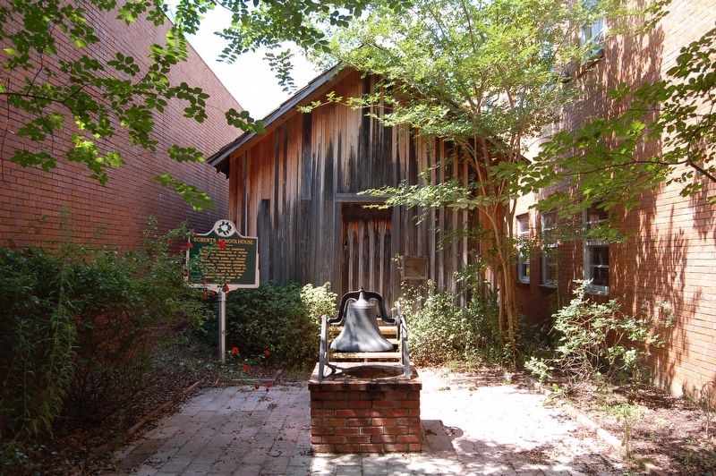
This schoolhouse was established
in the Arena community of Jackson
County by Richard Roberts in the
1890s. Serving grades one through
twelve, the curriculum consisted
of reading, writing and arlthmetic.
The Roberts Schoolhouse closed . . . — — Map (db m118441) HM
On Mobile Street north of East Sixth Street, on the left when traveling north.
Rock and roll is rooted in the blues of Mississippi. The Mississippi Jook Band (brothers Roosevelt and Uaroy Graves and pianist Cooney Vaughan) earned a niche in the annals of rock after they recorded in Hattiesburg in 1936, nearly two decades . . . — — Map (db m118400) HM
On Forrest Street just north of West Front Street (U.S. 11), on the right when traveling north.
This building, the Saenger Theatre has been entered on the National Register of Historic Places by the U.S. Department of Interior May, 1979 ☆ ☆ ☆ Designed by New Orleans architect Emil Weil, the theatre opened on . . . — — Map (db m293035) HM
On East Fifth Street east of J D Randolph Street, on the right when traveling east.
Organized in 1882 in a wood frame structure on the present site. In 1926, the original building was damaged in a storm. The present structure was built in 1930. The congregation provided food and shelter for Hattiesburg's flood victims in 1963 and . . . — — Map (db m118455) HM
On Mobile Street north of East 5th Street, on the left when traveling north.
Taking our Rightful Place in History
The Birthplace of the Voting Rights Movement in Mississippi
Rev. I.C. Peay et al. vs. Luther Cox
It was here on Mobile Street at various businesses that 15 African-
American Men regularly met and . . . — — Map (db m175155) HM
Hattiesburg The Hub • New Orleans • Natchez • Jackson • Meridian • Mobile • Gulfport • Mayor Johnny L. Dupree, Ph.D. City Council Ward 1, Kim Bradley • Ward 2, Deborah Denard Delgado • Ward 3, Carter Carroll • Ward 4, C.E. Red Bailey • Ward 5, . . . — — Map (db m305000) HM
The Hub has been just that, the center of campus and campus life, since its construction as the Dining
Hall in 1930. By the 1960s, it housed the bookstore, post office, and coffee shop and grill known as Wimpy''s
and later Exit 13. Aspiring . . . — — Map (db m118443) HM
On Monroe Road 0.2 miles south of Bay Springs Road when traveling south.
Vernon Dahmer (1908-1966), a farmer, businessman, and Civil Rights leader widley known for his belief that "if you don't vote, you don't count" was killed here defending his home and family from a gunfire and firebomb attack on January 10, 1966. . . . — — Map (db m176297) HM
On Main Street at Batson Street, on the left when traveling north on Main Street.
Native of Kelly Settlement community, Forrest County. Landowner, farmer, grocer, saw and plane mill operator, employer, church music director, and father of eight. Multi-term President of the Forrest County Branch of the National Association for . . . — — Map (db m292900) HM
On Stepts Avenue north of J M Tatum Industrial Drive, on the right when traveling north.
Victoria Jackson Gray Adams was the Mississippi
supervisor of the Southern Christian Leadership
Conference's (SCLC) Citizenship Education Program,
a founder of the Mississippi Freedom Democratic
Party (MFDP), and the first African . . . — — Map (db m312332) HM
E. 1 mi. Founded 1906 as S. Miss. College. Operated by Bapt. as Miss. Woman's College 1911-40. Coeducational 1953. Name changed to honor William Carey, 18th century English missionary. — — Map (db m39896) HM
On West Pine Street (U.S. 11) at Forrest Street on West Pine Street.
In 1880 near the banks of Gordon Creek, this lawyer, railroad builder and Confederate veteran selected the site for Hattiesburg. Incorporated in 1884, the town was named for Hardy's wife, Hattie Lott. — — Map (db m40050) HM
On West Front Street (U.S. 11) at Dudley West Conner Street, on the left when traveling west on West Front Street.
Builder of Railroads
Pioneer in the Development
of the Resources of
South Mississippi
Founder of the Cities of
Hattiesburg and Gulfport
A Dreamer
Whose dreams Came True — — Map (db m76705) HM
"When I leave this world, I can't carry nothing away from here. Whatever I have,
it's going to be left right here for somebody. Some child can get their education, to
help them along, because you can't do nothing now unless you get your . . . — — Map (db m226249) HM
On East Memorial Drive 0.5 miles north of Hardy Street (Mississippi Highway 198).
Made up of siliceous minerals, the
11-million-year-old southern miss petrified log
was found intact rather than in fragments.
According to Dr. Bobby Irby, then chairperson
of the USM Science Education Department and
coordinator of the . . . — — Map (db m226168) HM
On U.S. 49 0.8 miles north of Newton Field Road, in the median.
Area to south, originally part of French Louisiana, became West Florida under England and Spain. After West Florida Revolution annexed by U. S. and in 1812 was added to the Mississippi Territory. — — Map (db m39002) HM
On Macedonia Road at Morriston Road, on the right when traveling north on Macedonia Road.
Established here in what was then
Perry County on February 8, 1887,
with D. L. Carter as the first
Postmaster. Discontinued on
September 11, 1893, but reestablished
on January 10, 1894, with J. S.
Doyle as Postmaster. Named for
F. M. Morris . . . — — Map (db m206581) HM
On Sunrise Heights east of Sunrise Road, on the right when traveling east.
1889, W. R. Melton donated a
one-acre tract of land at this site
"for the cause of Religion and
Schools.” The school located here,
which served the Sunrise community,
was a one-room schoolhouse. Zion's
Hill Baptist Church (now Sunrise
Baptist . . . — — Map (db m175643) HM
On Oak Street at Summer Street, on the right when traveling east on Oak Street.
In 1898, E.E. Bolen established a nursery and orchard company in George County. Other wholesale nurseries were established in the early 1900s. The production of ornamental plants, trees and shrubs has since become a thriving commercial industry . . . — — Map (db m56545) HM
Near Mill Street just north of Oak Street, on the left when traveling north.
On Nov. 11 at 11:00 AM the sun will spotlight the plaque commemorating the date and time of the signing of the Armistice ending WW1. The citizens of Lucedale wish to thank all of our veterans for their service and sacrifice. Erected by . . . — — Map (db m286313) HM WM
Near River Street 0.1 miles east of McLeod Avenue, on the right.
In November 1864, Union Brig. Gen. John
Davidson led an expedition from Baton
Rouge toward the Mobile & Ohio R.R. On
December 10, part of his force crossed
the Chickasawhay River and met two
Confederate cavalry regiments at McLeods
Mill. . . . — — Map (db m122344) HM
On Main Street (Mississippi Route 63) at Dietz Avenue, on the right when traveling east on Main Street.
Born in Crystal Springs, Byron Patton
Harrison (1881-1941) came to Leakesville
and taught in the local high school from
ca. 1900 until 1902, when he opened
his first law practice near this area.
Appointed as the town's first Marshall, . . . — — Map (db m122345) HM
On Main Street (Mississippi Route 63/57) at Lafayette Avenue, on the right when traveling west on Main Street.
This monument is dedicated to a large group of
men that was formed here. These men were
common men with an uncommon valor in war
they fought for their homes, families and a
constitutional government most were early
settlers of Greene . . . — — Map (db m122702) WM
On Old Avera Road 0.1 miles south of Kate James Road, on the right when traveling north.
The Clark Cemetery was established by
W.M.B. Clark (1809-1881) in 1879 with
the burial of С.С. McInnis, born in 1804.
It is the final resting place of a number
of Greene County businessmen, legislators,
county officials and . . . — — Map (db m122334) HM
On State Highway 15 at Commerce Drive, on the right when traveling north on State Highway 15.
On July 23, 1890, Marsh Cook of Jasper County was gunned down by six men after warning citizens that the 1890 Mississippi Constitutional Convention would likely limit voting rights and disfranchise black voters. Cook was a white Republican candidate . . . — — Map (db m56188) HM
On State Highway 15 0.1 miles north of Commerce Drive, on the left when traveling north.
One of routes of military & post road begun, 1807, from Natchez to Ft. Stoddert & Milledgeville, Ga. Over this trail many immigrants came into Territory & here Sam Dale operated wagon train. — — Map (db m56544) HM
On County Highway 20 0.2 miles west of State Highway 15, on the left when traveling west.
Organized on July 31, 1841, with eighteen members. The present church was built in 1907. The first pastor was Dr. John H. Gray. Dr. John N. Waddel, a charter member who donated the land for the church and cemetery, served as Chancellor of the . . . — — Map (db m173381) HM
On State Highway 13 0.2 miles south of State Highway 184, on the right when traveling south.
Oldest organized Baptist Church in Jefferson Davis County. Organized in 1818. First pastor, Norvell Robertson, served for 40 years. — — Map (db m173376) HM
On J E Johnson Road 1.6 miles south of State Highway 13/184, on the left when traveling south.
Jonas E. and Bertha L. Johnson founded the Prentiss Normal and Industrial Institute In 1907. Patterned after the Tuskegee Institute, where Mrs. Johnson (1882-1971) studied under Booker T. Washington, it was the only high school for African . . . — — Map (db m276596) HM
On East St Stephens Road 0.1 miles east of J E Johnson Road, on the left when traveling east.
Tobias Magee, a veteran of the War of 1812, came to Mississippi ca. 1815, where he and his wife, Nancy Stevens Magee, reared their seventeen children. By 1841 Magee had purchased over eighty acres of land in this area and began to raise cotton and . . . — — Map (db m173374) HM
On Anderson Street at North Deason Street, on the left when traveling west on Anderson Street.
This one-story, Greek Revival-style house was constructed ca. 1847 with a wood façade shaped to resemble stone blocks and a hexagon-shaped entrance vestibule. On October 5, 1863 Confederate Major Amos McLemore, who had been sent to the area to round . . . — — Map (db m73449) HM
On U.S. 11 south of Ellisville State School Rd, on the right when traveling south.
Established in 1920 and officially known as the Mississippi School and Colony for the Feebleminded, this facility opened in 1921. The name changed to Ellisville State School in 1929 after the addition of an educational program. In the 1970s, federal . . . — — Map (db m275160) HM
On Stadium Avenue south of College Drive, on the right when traveling north.
On December 10, 1955, under threat of losing state and local funding, Jones County Junior College became the first athletic team from Mississippi to cross racial barriers and play an integrated team. Before the largest crowd ever to witness the . . . — — Map (db m287038) HM
On Hill Street at Calhoun Street, on the right when traveling south on Hill Street.
Jones County was established in 1826 with two county seats, Ellisville and Laurel. This courthouse was designed by architect Penn Jeffries (P.J.) Krouse and constructed by Norris and Gardner in 1908, with the Laurel courthouse in 1908, as its twin. . . . — — Map (db m111002) HM
On U.S. 11 at Main Street, on the right when traveling north on U.S. 11.
On June 26, 1919, John Hartfield, an African American, was lynched in Ellisville allegedly for raping his White girlfriend. After being apprehended by the county sheriff, he was turned over to a mob. The lynching was announced in advance by . . . — — Map (db m287112) HM
Near College Drive east of Bush Drive, on the left when traveling east.
Korean War
In Honor of Personnel
Called to
Active Federal Duty
August 19, 1950
932 Medical Clearing Company
of the
Mississippi National Guard
From
Jones County Junior College
-May The Memory Live . . . — — Map (db m287057) WM
On Hal Crocker Road at U.S. 29, on the right when traveling west on Hal Crocker Road.
Newt Knight: Robin Hood or Renegade?
On October 5, 1863, Major McLemore sat in front of the fire in the comfortable home of Amos Deason. He had been sent from Atlanta to round up a growing number of deserters who hid out in the swamps of . . . — — Map (db m129103) HM
On Mississippi Route 588 0.7 miles west of County Home Road, on the right when traveling west.
Near this site on June 25, 1863, a small group of Confederate soldiers and civilians under the command of Lt. W. M. Wilson of the 43rd Tennessee Infantry, defeated a detachment of the 5th Illinois Cavalry. During the skirmish, the entire 40 man . . . — — Map (db m61931) HM
On Leontyne Price Boulevard 0.1 miles north of Home Street, on the right.
Established on August 8, 1938, the Housing Authority of the City of Laurel completed construction on two sites in 1940 for public housing. Beacon Homes, located here, was designated for White families. This development was located less than half . . . — — Map (db m287042) HM
On Oak Park Boulevard west of Queensburg Avenue, on the right when traveling west.
Benjamin Ellery Murph, a dentist and civil
rights leader, was the charter vice president of
the Laurel-Jones County NAACP in 1947 before
becoming president four years later. Throughout
the 1950s and 1960s, Murph expanded youth
councils . . . — — Map (db m312329) HM
On Jefferson Street west of South 4th Avenue, on the right when traveling west.
On March 19, 1968, Dr. Martin Luther King Jr. spoke here at St. Paul Methodist Church to rally support for the Poor People's March on Washington against economic injustice. King told the overflow audience that the marchers were going to the . . . — — Map (db m110981) HM
On Susie B Ruffin Ave (U.S. 11) at E. 9th Street, on the left when traveling south on Susie B Ruffin Ave.
The first African American congregation in Laurel began meeting in 1892 and was affiliated with the African Methodist Episcopal (A.M.E.) Church. The church was named for Bishop Richard Allen, the denomination's founder, and its first pastor. Rev. . . . — — Map (db m275158) HM
On North 5th Avenue (State Highway 537) at West Oak Street, on the right when traveling south on North 5th Avenue.
Constructed in 1914, the Hotel Pinehurst was owned and operated by T.B. Horton until 1939. The hotel included over 100 rooms, a grand lobby and entranceway, and a number of dining rooms, offices, and stores. The Arabian Theater was added in 1924. . . . — — Map (db m56546) HM
On North Maple Street north of Central Avenue, on the left when traveling north.
The Laurel area, a hub of musical activity in southeast Mississippi, has been home to a number of noted blues performers including harmonica player Sam Myers, singer Albennie Jones, and guitarist Blind Roosevelt Graves. R&B, blues, and rock 'n' . . . — — Map (db m110992) HM
On North 5th Avenue (Mississippi Route 537) south of West 5th Street, on the right when traveling north.
This property has been
placed on the
National Register
of Historic Places
by the United States
Department of the Interior
Circa 1907 — — Map (db m126691) HM
On North 5th Avenue at Yates Avenue, on the right when traveling north on North 5th Avenue.
Opened on November 24, 1914, this building once housed all of Laurel's city officials, as well as the fire and police departments. Laurel City Hall was designed by architect Penn Jeffries Krouse and is an early example of the eclectic Mediterranean . . . — — Map (db m110979) HM
On Limbert Street at South 4th Avenue, on the right when traveling north on Limbert Street.
In 1924 engineer William H. Mason discovered a process to convert wood chips into a thin, high density material that became known as masonite. He established the Mason Fibre Company soon after his discovery. The company changed its name to the . . . — — Map (db m110983) HM
On Queensburg Avenue at Oak Park Boulevard, on the right when traveling north on Queensburg Avenue.
Oak Park Vocational High School, located at this site, opened in September, 1928. Based on the pattern of Tuskegee Institute, the school provided academic, vocational, and agricultural education to African American students, and included faculty . . . — — Map (db m110988) HM
On Queensburg Avenue north of Brown Street, on the right when traveling north.
Born in Laurel on May 9, 1939, Ralph Boston became a star athlete at Oak Park High School. While attending Tennessee State (1957-1962), Boston set records in the high jump, sprints, high hurdles, and long jump. Earning a spot on three successive . . . — — Map (db m110990) HM
On South Maple Street near South 4th Avenue, on the right when traveling north.
Established on August 8, 1938, the Housing Authority of the City of Laurel completed construction on two sites in 1940 for public housing. Triangle Homes, located here, was designated for African American families. Named for the triangle formed . . . — — Map (db m287043) HM
On Big Creek Church Road at U.S. 84, on the right when traveling north on Big Creek Church Road.
Org. 1820s. Oldest Landmark church in county. At break-up of Ebenezer Assn., it led in organizing Big Creek Missionary Baptist Assn. Dykes, Hilburn, Hill, Jefcoat, Knight, Shows, Sumrall, Todd, & Wade families led in church growth. — — Map (db m111001) HM
Near Tatum Salt Dome Road 5 miles north of State Highway 13.
Experiments in the Vela Uniform Program sponsored
jointly by the Department of Defense and the Atomic
Energy Commission were conducted below this spot
at a depth of 2700 and 2715 feet in salt. A 33 kiloton
nuclear devise was detonated on . . . — — Map (db m197264) HM
On Richburg Road at Sullivan Kilrain Road, on the right when traveling north on Richburg Road.
The last bare knuckle prize fight was fought here on Richburg Hill July 8, 1889.
John L. Sullivan defeated Jake Kilrain in the seventy-fifth round to retain the World Heavyweight Championship.
John L. Sullivan and Jake Kilrain were both . . . — — Map (db m118378) HM
On West Main Street (State Highway 13) at South 2nd Street, on the right when traveling east on West Main Street.
Area to south, originally part of French Louisiana became W. Florida under England & Spain. After West Florida Revolution annexed by U.S. & in 1812 added to Miss. Territory. — — Map (db m97104) HM
On Bay Creek Road near Purvis to Columbia Road, on the left when traveling north.
Established in 1896 by Rev. Joseph Lewis
Bryant, a member of the Mississippi House
of Representatives (1908-1912). Bryant
also served as the cogregation's first
pastor. The first sanctuary was built
in the early 1900s, and was replaced
in 1938 . . . — — Map (db m175806) HM
On Shelby Speights Road west of Weems Street, on the right when traveling west.
Scene of destructive tornado on April 24, 1908. Forty-seven people were killed and more than 300 injured. Over half of the homes were destroyed. Property damage was great. — — Map (db m118379) HM
On Caswell Street north of East Broad Street, on the right when traveling north.
Former home of Governor Andrew H. Longino, who served as legislator, judge, and county official. New capitol building erected and primary election law passed during his term. — — Map (db m70809) HM
On Brookhaven Street, on the right when traveling north.
Est. 1810 by Jos. Cooper, one blk. N. Primary reason St. Stephens Rd. took this route in 1812 from St. Stephens (Ala.) on the Tombigbee to Natchez. Site served as boat landing from 1826 through early 20th century. — — Map (db m50158) HM
On East Broad Street at Caswell Street, on the right when traveling east on East Broad Street.
½ blk. N, built 1884. Restored by Lawrence Co. Hist. Soc. Longino was gov. of Miss., 1901-1904. During his term New Capitol built; Dept. of Archives & Hist. and state penal farm estab.; public school system improved. — — Map (db m70776) HM
On East Broad Street (State Highway 184) just east of Washington Street, on the right when traveling east.
[side 1] Patriot Captain in the Georgia Continental Line during the Revolutionary War. He came to the Mississippi Territory in 1810, purchasing two land sections in 1811, along the Pearl River's western bank, which was the . . . — — Map (db m276600) HM
On East Broad Street, on the right when traveling west.
Monticello area native J. B. Lenoir (1929-1967) was best known during his lifetime for his 1955 hit “Mama, Talk to Your Daughter,” but he also played an important role in blues history because of his political engagement. In the 1960s Lenoir . . . — — Map (db m79029) HM
On State Highway 27, on the right when traveling south.
Here was the upper line of Mt. Dexter Treaty grant, 1805, from which came counties of Wayne, Green, Marion, Lawrence, Pike, Covington, Perry, Jones, Lincoln, Lamar, Forrest, J.Davis, & Walthall — — Map (db m50159) HM
On Southern Avenue (State Highway 184) at 4th Street, on the right when traveling west on Southern Avenue.
South 4 miles. Chartered in 1815. Congregation set up with fifteen charter members by Revs. William Cooper and George King. April 4, 1818. — — Map (db m276807) HM
On State Highway 184 at Old St. Stephens Road (Arm Road) (State Highway 43), on the right when traveling north on State Highway 184.
By this spot ran the St. Stephens Road, a route est. ca. 1812 to connect Fort St. Stephens, now in Alabama, with the Mississippi territorial capitol at Natchez. — — Map (db m276833) HM
On East Baylis Chapel Road 0.1 miles east of Lampton Hilltop Road, on the left when traveling east.
Established in the late 1880s, Baylis Chapel
Methodist Church is located on land donated by
George Baylis in 1882. The original wooden
structure, built in the late 1880s, was replaced by
the current church building in 1951. Among the
oldest . . . — — Map (db m206683) HM
Near Broad Street at Alberta Avenue, on the right when traveling east.
Mississippi's first rodeo was held here September 24-26, 1935. The rodeo was sponsored by two local businessmen, rancher Samuel Hickman of the B Bar H Ranch and George Baylis, owner of the Baylis Drug Store. Several notable cowboys were involved, . . . — — Map (db m143125) HM
In 1883, Pastor T. S. Howell from Bunker Hill Church in rural Marion County, and six local believers met at the courthouse to organize a Baptist church within the city limits of Columbia. Early meetings were held in the courthouse, the Masonic Hall, . . . — — Map (db m50135) HM
On Broad Street west of Sumrall Road (State Highway 44), on the left when traveling west.
Built between 1925 and 1927 by Jackson architect Claude H. Lindsley and furnished by Marshall Fields, this Spanish Colonial Revival-style mansion was the home of Governor Hugh Lawson White. White served two non-consecutive terms as governor of . . . — — Map (db m115552) HM
On February 7, 1894, crowds gathered near this site to witness the hanging of Will Purvis, who had been convicted of the murder of local farmer Will Buckley. When the trap door was released Purvis fell straight through to the ground, the noose . . . — — Map (db m115404) HM
On Broad Street (State Road 13) south of Meak Alley, on the right when traveling south.
Honoring those who served and
dedicated to the everlasting memory
of the men from Marion County, Miss.,
who gave their lives, in all wars,
for their state and nation.
Those who gave their lives
1914 – World War I – . . . — — Map (db m243150) WM
On Rural Center Road at State Highway 13, on the left when traveling south on Rural Center Road.
The Mississippi Rural Center was dedicated on February 9, 1949, and established with a $100,000 gift from the Women's Society of Christian Services of the Methodist Church. Created to provide opportunities for African American families, the center . . . — — Map (db m115553) HM
On Lampton Hilltop Road at W. Baylis Chapel Road, on the right when traveling east on Lampton Hilltop Road.
Established 1864, the Simmons
Cemetery is the burial place for
descendants of William F. and
Zuleika Simmons and is associated
with the Keno community, founded
in 1855. In 1889. a post office
was established at the Baylis
mill. The earliest . . . — — Map (db m206617) HM
On Main Street (State Highway 13), on the left when traveling west.
The 5th session of the Mississippi Legislature met in Columbia in Nov. 1821, and in a special session in June 1822. Walter Leake was inaugurated Governor here in January 1822; the Legislature passed laws for the education of the poor; approved Le . . . — — Map (db m50070) HM
On U.S. 98 at State Highway 35, on the right when traveling east on U.S. 98.
Located 16 miles south, is oldest house in Pearl River Valley. Built by Methodist preacher, John Ford, who came in 1805 from S.C. Here Pearl R. Convention met in 1816. — — Map (db m115452) HM
On State Highway 586 0.5 miles west of Old Foxworth - Jamesworth Road (State Highway 587), on the left when traveling west.
Believed to have been the last surviving
American Slave, Magee was born in Carpet,
North Carolina and sold at Enterprise,
Mississippi at the age of nineteen. He is
believed to have served in the Civil War at
both the Siege of Vicksburg and . . . — — Map (db m196209) HM
Once known as Beardsville and Claude,
Morgantown was settled ca. 1815 by Francis and
William Lenoir, George Nixon, Robert Baylor,
and Robert McGowan. The name was suggested
by Lizzie Morgan as early as 1909. In 1884.
C.N. Beard opened a school . . . — — Map (db m206577) HM
On State Highway 35 at Rankin Creek Road, on the right when traveling north on State Highway 35.
Located one mile east. The oldest house in Pearl River Valley. Built about 1805 by Methodist preacher, John Ford, who came from South Carolina. Andrew Jackson stopped here, 1814, enroute to New Orleans. — — Map (db m115379) HM
On U.S. 11 near Tate Street, on the right when traveling south.
Pearl River County was formed after the Civil War from portions of Hancock and Marion Counties. The following Confederate military units were formed in those two parent counties of Pearl River County.
Hancock County: Capt. Robards' Company . . . — — Map (db m103258) HM
On Goodyear Boulevard at Williams Avenue, in the median on Goodyear Boulevard.
Lumber and tung-oil center. Named for N.O. newspaper edited by former local resident, Eliza Jane Nicholson, famed as poet (Pearl Rivers) and pioneer in opening of journalism to women. — — Map (db m103251) HM
On North Jackson Avenue north of East Canal Street, on the right when traveling north.
Picayune's first public high school for African
Americans was established here in 1918. John
Prentiss (J.P.) Johnson served as principal from
1943 to 1950, when a new school was constructed
at another location in Picayune. He continued
as . . . — — Map (db m149632) HM
On Ridge Road 0.2 miles south of Freirson Road, on the right when traveling south.
Dedicated on November 23, 1986, the
Pinecote Pavilion was built by the family
of L.O. Crosby, Jr. (1907-1978) as a memorial
to his legacy. Crosby was a noted forestry
figure, philanthropist, and civic leader who
held a deep love for nature. . . . — — Map (db m149700) HM
On U.S. 11 near Tate Street, on the right when traveling south.
The Logo symbolizes the Southern Railroad which took over the rail system from New Orleans and Northeastern Railroads on or about 1915. The Logo was initially placed in Picayune in 1917 where it remained until it was damaged by construction in 2008. . . . — — Map (db m103396) HM
On U.S. 11 at Tate Street, on the right when traveling south on U.S. 11.
Tank Car CROX 2027 was originally owned by Crosby Chemical Company, then sold to Arizona Chemical Company. When Arizona Chemical closed it was donated to the City of Picayune. The track on which it is located on is an original spur dating back to . . . — — Map (db m103250) HM
Organized in March 1862 by Capt. D.B. Seal at Hobolochitto (now Picayune), the "Hancock Rebels" became Co. C, 38th Mississippi Infantry, C.S.A. Seeing action at Corinth, Iuka, and Vicksburg, the unit was mounted in 1864 and served under Nathan B. . . . — — Map (db m49065) HM
On State Highway 43 0.2 miles north of Mitchell Chapel Road, on the left when traveling north.
John Wheat, an early settler
and Revolutionary War soldier,
is buried here, along with other
members of the Wheat family,
including sons John and William
Wheat, who served in the War
of 1812, and grandsons James
A. and William G. Wheat, . . . — — Map (db m206578) HM
On South Julia Street north of West Pearl Street, on the left when traveling north.
The first courthouse for Pearl River County was built on this site in 1891-1892. It served the county until it was replaced by a new courthouse constructed across the street, in 1918. — — Map (db m118386) HM
On U.S. 98 at Main Street, on the right when traveling west on U.S. 98.
Two miles north, on banks of Leaf River. Famous as the first county seat of Perry County and site of trial of the famous outlaw, James Copeland. Served also as U.S. land office. — — Map (db m120885) HM
On Front Street at Dogwood Avenue (State Highway 42), on the left when traveling north on Front Street.
In 1931, the E.A. Emery family donated their home and property to establish a maternity home for unwed mothers and their babies. Mable Cooper, a minister in the Missionary Bands of the World of Indiana, served as superintendent of the home until . . . — — Map (db m276529) HM
On State Highway 37 just north of State Highway 80, on the right when traveling north.
Center Ridge School, established in the late 19th century, was located at this site. A white, framed building, the school served the Center Ridge community until 1956, when it was consolidated with a nearby school. The Unity United Methodist Church, . . . — — Map (db m57557) HM
On Sylvarena Avenue at Main Street (State Highway 35), on the right when traveling east on Sylvarena Avenue.
Built ca. 1845, the hotel once located on this site was among the first public buildings in Raleigh. During the Civil War, it was used as headquarters for Col. Robert Lowry, future governor of Mississippi. Political figures, including Jefferson . . . — — Map (db m173380) HM
On Main Street (Route 35), on the right when traveling north.
First incorporated in 1838.
Raleigh succeeded Fairfield as
the county seat of Smith Co.
The town, earlier known as
Indian Springs, was formed in
1835. Home of the National
Tobacco Spitting Contest. — — Map (db m284574) HM
On State Highway 35 south of County Road 120, on the left when traveling south.
The frontier town of Shongelo was
located here around the grist mill
of C.D. Austin. Constructed in the
early 1800s, the mill was powered
by water flowing from seven springs
found in hollows east of this site.
By 1923, the Shongelo . . . — — Map (db m284581) HM
On Main Street (State Highway 35) at Court House Square, on the right when traveling south on Main Street.
Built in 1913, the Smith County Courthouse was designed by the Weathers-Foley Company of Memphis in the Neo-Classical Style. Cost of construction was $50.000. The present structure replaced an earlier courthouse on this site, built in 1892, which . . . — — Map (db m173379) HM
A noted poet, editor, and educator, John Crowe Ransom (1888-1974) was one of a group of southern agrarian poets known as the Fugitives. Ransom's first teaching position, at age 17, was at Taylorsville High School (1905-1906). He later became a . . . — — Map (db m59303) HM