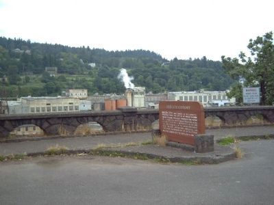
On McLoughlin Boulevard (Oregon Route 99) near S. 2nd Street, on the right when traveling south.
Oregon City - once known as Willamette Falls - was early the site of an Indian salmon fishing village. The falls furnished the power for a lumber mill which began operation in 1842. A flour mill in 1844. A woolen mill in 1864 and the first paper . . . — — Map (db m113515) HM
Erected by the citizens of this pioneer Oregon community, this elevator tower replaces an original wood and steel structure, which was first advocated in 1899, and eventually constructed in 1913 on the west side of the railroad
tracks. The . . . — — Map (db m296934) HM
On McLoughlin Boulevard (Oregon Route 99) near South 2nd Street, on the right when traveling south.
400 feet south
of this marker
stood the home of
Peter Skene Ogden
Chief Factor of
Hudson's Bay Co.
and rescuer of the
survivors of the
Whitman Massacre. — — Map (db m8714) HM
Near Washington Street near Abernethy Road, on the right when traveling north.
'It was two stories, 68 x 105, and was the first hotel west of the Rocky mountains." -- Harvey K. Hines, An Illustrated History... (1893)
In 1842 Dr. Elijah White recruited over one hundred people to emigrate across the Oregon Trail. . . . — — Map (db m114165) HM
On South Gronlund Road near Carver Road, on the right when traveling west.
Horace Baker emigrated from Illinois along the Oregon Traill in 1846 and married fellow emigrant Jane Hatten in 1852. The Bakers claimed 640 acres and built this cabin by 1856. The Baker Cabin is one of the oldest log structure in the state, and it . . . — — Map (db m114230) HM
Near South Gronlund Road near Carver Road, on the right when traveling west.
Little is known about the first ten years after Horace and Jane Baker arrived in the 1846 Barlow Trail wagon train, and the construction of this cabin. Perhaps, like most pioneers they lived out of their wagon or tents the first winter. Most then . . . — — Map (db m114233) HM
Near South Gronlund Road near Carver Road, on the right when traveling west.
The Barlow Trail branch of the Oregon Trail formally ended at the Phillip Foster Farm near Eagle Creek. From that point immigrants fanned out, taking several routes to Oregon City and beyond. One route passed this spot on the way up Gronlund Road to . . . — — Map (db m114235) HM
Near Washington Street near Abernethy Road, on the right when traveling north.
The Clowewalla (also known as the Willamette Tumwater) and Clackamas Chinooks were relocated to the Grand Ronde Reservation under the Treaty with the Kalapuya, Etc. 1855 (also known as the Willamette Valley Treaty).
The Clowewalla joined other . . . — — Map (db m114063) HM
Near Washington Street near Abernethy Road, on the right when traveling north.
When she went shortly after to her American woman friend, she told her, "They are going to take you Indian people somewhere pretty soon now." She told her, "Do not leave anything. Take along all your things with you. Put your canoe . . . — — Map (db m114762) HM
Near Washington Street near Abernethy Road, on the right when traveling north.
"Past on twelve miles or more, took the (w)rong road and arrived at the Willammette bottoms about dark a little below the City." -- Samuel Dexter Francis, October 14, 1852
In September and October, and early November the meadows at the . . . — — Map (db m114136) HM
Near Tumwater Drive near McLoughlin Boulevard ( Highway 99).
In memory of all who gave their lives for the preservation of American Freedom
Spanish American War
World War I
World War II
Harold L. Adams •
Harold D. Alt •
Alfred W. Anderson •
Harold A. Anderson •
Robert C. Baker •
Herman v. . . . — — Map (db m13264) HM
Near Washington Street near Abernethy Road when traveling north.
Letters in newspapers, emigrant guide-books, and word of mouth gave counsel on overland travel. Emigrants commonly used farm wagons - simple, well-made, and utilitarian. Many were home-made or commission-built by local wagon makers. Some had custom . . . — — Map (db m114761) HM
Near Washington Street near Abernethy Road, on the right when traveling north.
When travelers arrived at the End of the Oregon Trail, they found Willamette Falls, a natural wonder that attracted both those early settlers and the Native Americans who settled here centuries earlier. For the traditional peoples, the main . . . — — Map (db m114034) HM
Willamette Falls is the second-largest waterfall by volume in North America. From time immemorial through today, it has been a gathering place for Native Americans. In the 1800s, it was the birthplace of the Oregon Territory and a center of . . . — — Map (db m269858) HM
On Washington Street north of Abernathy Road, on the right when traveling north.
Oregon City Mills, looking across the river to the newly built Willamette Falls Locks, 1874. Visible are the Imperial Flour Mills, built in 1863-1864, and to its right the Oregon Manufacturing Company (Oregon Woolen Mills) which was established . . . — — Map (db m286195) HM
In 1851, Dr. John McLoughlin dedicated a 7.8-acre park along the bluff now known as the McLoughlin Promenade for the use of the citizens of Oregon City. In 1938, a concrete pathway lined by stone walls and an adjoining grand staircase were . . . — — Map (db m269857) HM
On Mt. Hood Highway (U.S. 26), on the left when traveling west.
The pioneer road here detoured the Columbia River rapids and Mount Hood to the Willamette Valley. The road at first followed an old Indian trail. The later name was Barlow Road. Travel was difficult. Wagons were snubbed to trees by ropes on held . . . — — Map (db m112372) HM
On Woodburn-Sandy Highway/Meinig Avenue (State Highway 211) at Mount Hood Highway/Pioneer Boulevard (U.S. 26), on the right when traveling north on Woodburn-Sandy Highway/Meinig Avenue.
[Marker on Monument's front]:
In memory of veterans who served in all wars
"Never to be Forgotten"
Donated to the City of Sandy, Oregon
and dedicated on November 11, 1987 by members
of the Veterans of Foreign Wars of
the United . . . — — Map (db m8573) HM
On Mt. Hood Highway (U.S. 26) at Main Park Road, on the left when traveling west on Mt. Hood Highway.
In the shadow of the tall trees, a stream of travelers crossed ash flows, talus slopes and boggy wetlands along this last stretch of the trail. Some emigrants were forced to abandon their wagons with the death of livestock and walk, carrying their . . . — — Map (db m112341) HM
On Northbound Rest Area (Interstate 205), on the right when traveling north.
Chief factor of the Hudson’s Bay Company at Fort Vancouver, philanthropist, and founder of Oregon City. The land on the east bank of the Willamette River at the falls was claimed by Dr. McLoughlin and the Hudson’s Bay Co. in 1828-29. First called . . . — — Map (db m8669) HM
On Northbound Rest Area (Interstate 205), on the right when traveling north.
From 1845 to 1849, George Abernethy was the first Provisional Governor of the Oregon Country, which extended from the Pacific Ocean to the Rocky Mountains and from California to Northern British Columbia. After arriving in Oregon in 1840 as part of . . . — — Map (db m8670) HM
On Northbound Rest Area (Interstate 205), on the right when traveling north.
Was early the site of an Indian salmon fishing village. The falls furnished the power for a lumber mill which began operation in 1842, a flour mill in 1844, a woolen mill in 1864 and the first paper mill in the Pacific Northwest in 1867. The first . . . — — Map (db m113514) HM
On Northbound Rest Area (Interstate 205), on the right when traveling north.
Still in use below this point-were opened on New Years Day, 1873, when the steamer Maria Wilkins became the first vessel to navigate up the west end of Willamette Falls. Farming and shipping interests had long sought to eliminate expensive portages . . . — — Map (db m8667) HM
Many of Oregon’s early transportation routes resulted from the efforts of enterprising pioneers like the Boone family of Clackamas County. In 1846 Alphonso Boone, grandson of Daniel Boone, emigrated to Oregon via the Applegate Trail with his large . . . — — Map (db m127162) HM
On SW Boones Ferry Rd at SW 5th St, on the left when traveling south on SW Boones Ferry Rd.
Built in 1903, this building was important to area social life, serving as Wilsonville's first “community center.”
Meetings were held in a lodge hall that occupied the second floor. Area residents would also flock to the upstairs . . . — — Map (db m127203) HM
On Boeckman Road, on the right when traveling east.
German immigrant farmers, attracted by the fertile fields of eastern Wilsonville, settled in this area and in 1878 founded Die Deutsche Evangelishe Reformierte Meridian Gemeinde des Clackamas County, Oregon, now the Meridian United Church . . . — — Map (db m231882) HM
The Grove of the States includes a tree representing each state in the USA and the District of Columbia. The idea for the Grove of the States was conceived by Oregon Attorney General Robert Y. Thornton to honor the passage of Lady Bird Jonson's 1965 . . . — — Map (db m127210) HM
On SW Boones Ferry Rd at SW 5th St, on the left when traveling south on SW Boones Ferry Rd.
Built at the turn of the 20th Century, the Norris Young Machine Shop served the farming community. Young, an accomplished machinist and inventor, repaired farm machinery and logging equipment.
Young was an enterprising businessman who along . . . — — Map (db m127204) HM
On SW Boones Ferry Rd, on the right when traveling south.
Built in 1905 and named for its colorful owner, Bill Flynn’s Saloon was a favorite hangout for residents and weary travelers. Farmers would park their wagons outside the saloon to rest their horses before the climb up “Whiskey Hill,” . . . — — Map (db m127205) HM
On SW Boones Ferry Rd, on the right when traveling south.
The Oregon Electric Railway was completed during the first decade of the 1900s, coming initially from Portland to Wilsonville, then on to Salem and Eugene after construction of a mile-long trestle across the Willamette River was completed in 1907. . . . — — Map (db m127219) HM
On South West Boones Ferry Road near South West Tauchman Street, on the left when traveling south.
The Tauchman House overlooks the site of one of the Willamette River's first ferry operations, started in 1847 by Daniel Boone's grandson, Col. Alphonso Boone.
In the early days, the ferry boat transported passengers, wagons and livestock . . . — — Map (db m114278) HM
On SW Boones Ferry Rd, on the right when traveling north.
The Wilsonville Methodist Episcopal Church, fondly referred to by residents as the “Old Church,” was dedicated on Aug. 27, 1911. Upon its opening, the building was debt-free and complete with an organ purchased during the construction . . . — — Map (db m127208) HM
On SW 5th St at SW Magnolia Ave, on the right when traveling east on SW 5th St.
Built in 1905, The Cottage Hotel is one of the many buildings constructed during the time that the Oregon Electric Railway ran through Wilsonville. The hotel’s business was directly dependent on the railroad’s passenger service. A boardwalk ran from . . . — — Map (db m127206) HM
On Boones Ferry Road, on the right when traveling south.
Baseball was a popular past time in Wilsonville during an era community baseball that ran around 1910 to 1930. The highlight was 1914, the year the Wilsonville Athletic Club won the state Championship.
Regular Sunday play on this site was . . . — — Map (db m76951) HM
Near Columbia River Highway (U.S. 30) near Clifton/Shingle Mill Road, on the right when traveling west.
"Captain" John West was a self-made man. A native of Scotland, he settled on the lower Columbia River near this spot in the early 1850s after trying his luck in the goldfields of California. West built and operated sawmills, ran a general store and . . . — — Map (db m113583) HM
On 2nd Street at I Street, on the right when traveling north on 2nd Street.
Dr. Charles Green Caples
-built 1870-
Knapp Social Center
Owned and maintained since 1959 by
the Oregon State Society of
the Daughters of the American Revolution — — Map (db m291816) HM
On Columbia River Highway (U.S. 30) near North Buck Way, on the right when traveling north. Reported missing.
Deer Island in the Columbia was named by the Lewis and Clark Expedition which stopped to dine here November 5, 1805 on its way down river. Homeward bound the explorers camped on the island on March 28,1806. Captain Clark recorded "This morning we . . . — — Map (db m194989) HM
On Columbia River Highway (U.S. 30) at SW Old Portland Road, on the left when traveling north on Columbia River Highway.
Panel 1
Once covered by an Ice Age ocean, then home to the Diersinno (Keeassino) Indian Tribe led by Chief Cassino, this area then became the meeting grounds for all the Northwest Indians who gathered each year to hold their . . . — — Map (db m113156) HM
On Columbia River Highway (U.S. 30) at SW Old Portland Road, on the left when traveling north on Columbia River Highway.
Lewis & Clark on the Columbia River
The Lewis and Clark Expedition made the first documented descent of the Columbia from the mouth of the Snake River to the Pacific.
This voyage strengthened the claim of the young United States to . . . — — Map (db m113157) HM
On Columbia River Highway (U.S. 30) at SW Old Portland Road, on the left when traveling north on Columbia River Highway.
Lewis & Clark and the Corps of Discovery
In 1803, the United States purchased the Louisiana Territory from France, expanding this country from the Mississippi River west to the Rocky Mountains and from the Gulf of Mexico north to . . . — — Map (db m113159) HM
On Columbia River Highway (U.S. 30) at SW Old Portland Road, on the left when traveling north on Columbia River Highway.
One of the Oregon Country’s most picturesque fur-traders, Thomas McKay is buried near Scappoose.
He was a daring leader, famous storyteller and could drive a nail with a rifle ball.
A Canadian, he arrived with the Astorians as a teen-age boy; . . . — — Map (db m114416) HM
On Yachts Landing at The Strand, on the left when traveling west on Yachts Landing.
The path before you represents the Corps of Discovery's journey on the Columbia River – from its confluence with the Snake to the Pacific Ocean.
Entering the Columbia in mid-October 1805, they travelled along the river from shore to shore . . . — — Map (db m113154) HM
On Yachts Landing west of The Strand, on the left when traveling west.
In 1804-06, Captains Meriwether Lewis and William Clark led 31 men and one dog on an epic journey.
President Thomas Jefferson commissioned this "Corps of Discovery" to find a route to the Pacific Ocean through the newly acquired Louisiana . . . — — Map (db m113155) HM
Near The Strand south of St. Helens Street, on the left when traveling south.
In October 1856, the U.S. Lighthouse Board entered this fog bell and Cape Disappointment Lighthouse into service, thus establishing the first light station on the Oregon and Washington coast.
Positioned on the north side of the entrance to . . . — — Map (db m113153) HM
Near McKenzie Highway (Oregon Route 242) 22 miles east of Route 126, on the left when traveling east.
When Dee Wright began work in 1910, he did not know where 24 years in the Forest Service would take him. Packing supplies for fire camps, work crews and lookouts; locating part of the Pacific Crest trail; and stories around the campfire all found . . . — — Map (db m114237) HM
Near Old McKenzie Highway (Oregon Route 242) 22 miles east of Route 126, on the left when traveling east.
This observation point has been provided to facilitate public enjoyment of the unusual and interesting combination of historical and geological features nearby. The development was planned and supervised by the Willamette National Forest and . . . — — Map (db m114229) HM
On Old McKenzie Highway (Oregon Route 242) 22 miles east of Route 126, on the left when traveling east.
This is a portion of the McKenzie Salt Springs and Deschutes Wagon Road constructed during the period 1866-1872. The route across these lava fields was rough and torturous. However it was 1,000 feet lower in elevation than the older Scott Trail . . . — — Map (db m114227) HM
On McKenzie Highway (Oregon Route 242) 20 miles east of Route 126, on the right when traveling east.
On the knoll behind this sign once stood a rustic cabin in which pioneer mailman John Templeton Craig died in December 1877.
Craig, who was 56, had been employed to carry the mail between McKenzie Bridge and Camp Polk, near Sisters.
While . . . — — Map (db m114234) HM
On McKenzie Highway (Oregon Route 242) west of Forest Road 260, on the right when traveling west.
In 1862 Felix Scott led a crew of 50 men who blazed a trail across the Cascade Mountains following an old Indian trail which skirted lava flows.
Scott hoped to use the new route to take supplies to gold fields in Idaho.
His trail was . . . — — Map (db m114245) HM
Near McKenzie Highway (Oregon Route 242) 22 miles east of Route 126, on the left when traveling east.
I was hired as a stone mason LEM for the Civilian Conservation Corps.
What’s a LEM you ask? Local Experienced Men.
Know all ‘bout stone masonry and it was wisely reasoned to pepper experienced man about the young Corps enrollees.
They’re . . . — — Map (db m114238) HM
Back in the 1930s and 1940s, this site was alive with the sounds of industry from across the river: the sharp drone of the 9-foot bandsaw... the thumps and rattles of lumber on the green chain... chugging steam engines... rattling train . . . — — Map (db m298140) HM
On North River Road near West Main Street, on the right when traveling north.
In 1846 Levi Scott, together with Jesse and Lindsay Applegate, led an expedition that established the southern route to Oregon from Ft. Hall, Idaho. He was also elected to guide the first emigrants over the new route. Scott's significant role in the . . . — — Map (db m112910) HM
On East Main Street at S 7th Street on East Main Street.
Looking east and west from this spot toward Main Street, it is easy to visualize the famous “parade scene” of this National Lampoon hit starring John Belushi. “Otter’s” room, “Pinto’s” room, and the pillow fight scenes were filmed one block south in . . . — — Map (db m297520) HM
On East Main Street at S 6th St, on the left when traveling west on East Main Street.
This property has been listed in the
National Register of Historic Places
by the National Park Service in partnership with the
Oregon State Historic Preservation Office.
Preservation of this historic property is supported by the . . . — — Map (db m297959) HM
On East Main Street, on the right when traveling west.
You are standing near the former tracks of an old railroad: the Oregon and Southeastern Railroad, called the ‘Old Slew and Easy.’
From 1889 to 1949, trains hauled lumber from the Row River Valley to be milled and used by local . . . — — Map (db m297593) HM
On South 10th Street at East Jefferson Ave, on the left when traveling south on South 10th Street.
Bohemia Mining Museum
The Bohemia Mining District, southeast of Cottage Grove, Oregon, was established in 1867 and covered roughly 60 square miles. With Bohemia Mountain as the hub of the district, it was the largest mineral producing . . . — — Map (db m297582) HM
On South River Road south of E Harrison Ave, on the left when traveling south.
Listed on the National Register of Historic Places
Original construction 1925
Restoration and dedication for public use
December 2011
Funded by:
National Historic Covered Bridge Preservation Program
American Recovery and . . . — — Map (db m298132) HM
On North H Street at Birch Avenue, on the left when traveling south on North H Street.
This octagonal building, constructed by Cottage Grove’s Our Lady of Perpetual Help in 1895, is the only one of its kind in the Pacific Northwest. The church cost $1,500 and took two years to complete. Archbishop William H. Gross of Portland . . . — — Map (db m297610) HM
In 1858, gold was discovered 30 miles east, along the upper Row River, just as the town of Cottage Grove was struggling to establish itself. For the next several decades, a series of gold rushes brought hopeful prospectors, rich investors and a . . . — — Map (db m298415) HM
On North River Road near West Main Street, on the right when traveling north.
Slowed by rugged trail conditions, weather, and weary teams, emigrants in 1846 entered the southern Willamette Valley in dire circumstances. Transit of the mountains between the Rogue River and the Willamette watershed took a terrible toll - . . . — — Map (db m112911) HM
On East Main Street at S 6th Street, on the left when traveling west on East Main Street.
This property has been placed on the
National Register of Historic Places
by the United States Department of the Interior
National Park Service
and is subject to the provisions of the
Oregon Special Assessment Program. . . . — — Map (db m297969) HM
On East Main Street, on the right when traveling east.
The Peace Tree project was inspired by the “One Sunny Day Initiative”, founded by atomic bomb survivor Hideko Tamura Snider. It aims to educate the public about the consequences of the use of nuclear weapons and plant seeds of peace, hope and . . . — — Map (db m297541) HM
The last train passed through the Chambers Bridge in 1951. Over the next half century, the bridge began to slowly fall apart. By 2000, it had a distinct lean and in 2010, a January windstorm threatened to bring the tall structure tumbling down. . . . — — Map (db m298139) HM
On East Main Street at S 7th Street, on the right when traveling north on East Main Street.
This mural is in memory of Lena Flaiskey Becker aka Eva Davenport. She was only here a few years, but her tragic story is woven into the fabric of our local history. We believe she came here with hopes of a better life with her husband Edwin who . . . — — Map (db m297604) HM
On East Main Street, on the right when traveling east.
Read All About It
View from Main Street and Hwy 99 looking East c. 1915. After the divisive Civil War, Americans sought a symbol of unity. The flag became one such symbol, and the Liberty Bell another. To help heal the wounds of the war, the . . . — — Map (db m297583) HM
The 1940s were the heyday of timber cutting here in the upper Willamette, with dozens of mills operating and around Cottage Grove. Millwork and work in the woods were the heartbeat of the town. The jobs were plentiful, the pay was good, and . . . — — Map (db m298433) HM
Imagine your home and school moved to avoid being covered by a lake!
This happened to 450 people living in the town of Dorena during construction of the dam in the 1940’s. The railroad tracks that once cut through the Row River Valley . . . — — Map (db m297584) HM
On South 6th Street, on the left when traveling south.
This property has been placed on the
National Register of Historic Places
by the United States Department of the Interior
National Park Service
and is subject to the provisions of the
Oregon Special Assessment Program
ORS . . . — — Map (db m297967) HM
On North River Road near West Main Street, on the right when traveling north.
Roads and rights-of-way were serious public considerations on the Oregon frontier. Market roads, territorial roads and county roads were the lifelines of commerce and communication. River Road - the road upon which you are standing - was once a . . . — — Map (db m112909) HM
On Layng Road south of Row River Road, on the right when traveling south.
Just upstream from this point, along the hillside, is the film location of this coming-of-age movie where the four 12 year old boys “dodge” the train. The bulk of the film was shot in the small town of Brownsville, 45 minutes north of here. . . . — — Map (db m297522) HM
Around the bend on this trail was the location of the well-known campfire scene where the four young boys shared their hopes and dreams. Emperor of the North’s (1973) opening scenes were also shot here, with Dorena Lake in the foreground. . . . — — Map (db m297531) HM
On East Main Street at S 8th Street, on the left when traveling west on East Main Street.
This property has been placed on the National Register of Historic Places by the United States Department of the Interior and is subject to the provisions of the Oregon Special Assessment Program.
ORS.358.475.565 — — Map (db m297943) HM
On North River Road near West Main Street, on the right when traveling north.
In 1846, Jesse Applegate and fourteen others from near Dallas, Oregon, established a trail south from the Willamette Valley and east to Fort Hall. This route offered emigrants an alternative to the perilous "last leg" of the Oregon Trail down the . . . — — Map (db m112908) HM
The Centennial Bridge was built in 1987 to celebrate the 100th anniversary of Cottage Grove. It was built by volunteers with recycled timbers from the Brumbaugh and Meadows bridges, and paid for with donations. Its Howe truss spans 84' and rests on . . . — — Map (db m99285) HM
On North River Road near West Main Street, on the right when traveling north.
The trail to Oregon was never a single set of wagon ruts etched from Missouri to the Willamette Valley. Wagons often traveled abreast through valleys and plains sometimes widening the trail several miles. In the mountains they constantly attempted . . . — — Map (db m112912) HM
This location played for Marietta, GA and was used for multiple locations in this Buster Keaton silent classic, including the film’s opening scene. Keaton utilized parallel tracks to get moving sequences and action shots on the train.
Did You . . . — — Map (db m297518) HM
On North H Street at Birch Avenue, on the left when traveling west on North H Street.
First stamp mill in the Bohemia mining area. In operation in 1871. It was hauled up to the gold mines on sled pulled by oxen team. Mill would stamp gold ore into a powder. Mixed with water the mud that was formed would wash down over a sheet of . . . — — Map (db m297606) HM
Despite its pastoral and its historic mining boom, Cottage Grove is a timber town through and through. Hundreds of miles of historic logging railroads and modern logging roads converge on this small, lively community. The town has been home to . . . — — Map (db m298417) HM
On South River Road, on the right when traveling north.
Imagine the time is around 1870... can you hear the sounds of early industry? Hammers are tapping square iron nails into wooden structures. Homes and businesses are being built across the road and on the river bank where more are springing up. . . . — — Map (db m298025) HM
On Row River Road, on the left when traveling east.
Just southeast of this spot, Buster Keaton shot the climactic crash scene of this Civil War era classic film. Multiple vintage trains from the Oregon, Pacific and Eastern Railway and area sawmills were used for the locomotive, “The General.” . . . — — Map (db m297585) HM
Site of the home of A. W. and Amanda Patterson. He was a pioneer Lane County doctor and surveyor who plotted a greater part of Eugene. In 1853, Patterson was also a member of the Oregon legislature and was instrumental in establishing the University . . . — — Map (db m112888) HM
Albert "Al" Gore, Jr., 45th Vice President of
the United States, is known for his ongoing
work regarding environmental issues. The
2007 Nobel Peace Prize was awarded jointly
to Al Gore and the Intergovernmental Panel
on Climate Change for . . . — — Map (db m157549) HM
American Friends Service Committee (AFSC),
is a Quaker-affiliated organization committed
to social justice, peace and humanitarian
service. In 1947, the Nobel Peace Prize was
awarded to the AFSC and the Friends Service
Council for their work to . . . — — Map (db m157434) HM
The Nobel Peace Prize
"...to the person who shall have done the most or
the best work for fraternity between nations, for the
abolition or reduction of standing armies and for the
holding and promotion of peace congresses. . . . — — Map (db m157418) HM
Barack Obama, 44th President of the United States,
worked to unite people in support of the value of
public service. President Obama was awarded the
Nobel Peace Prize in 2009 for his extraordinary
efforts to strengthen international diplomacy . . . — — Map (db m157492) HM
Charles G. Dawes, 30th Vice-President of the
United States, served as chairman of the
World War I Allied Reparations Commission.
Dawes achieved worldwide support for his
five-year plan to stabilize the German economy
and manage the country's . . . — — Map (db m157552) HM
Cordell Hull, Secretary of State for 11 years during
President Franklin Roosevelt's administration, worked
with countries to increase trade and lower taxes on
imports and exports. During WWII, Hull worked
to improve cooperation among the Allied . . . — — Map (db m157463) HM
Eliezer "Elie” Wiesel was a writer, professor and
survivor of the Holocaust. His writings on the
Holocaust helped the deepening understanding
of the tragic event across the world. As a
human rights activist, he worked for better
treatment . . . — — Map (db m157483) HM
Elihu Root, lawyer and statesman, dedicated
his life to solving international disputes. Root
believed a world court was the best way to solve
problems between countries. As Secretary of
State, he worked to improve the relationship
between Japan . . . — — Map (db m157473) HM
During the first half of the 20th century, Ellis Fuller Lawrence was one of Oregon's foremost architects. In 1914, he became the founder and first dean of the School of Architecture and Allied Arts at the University of Oregon. During his 32 year . . . — — Map (db m99251) HM
Emily G. Balch, academic and pacifist, lost her
professorship with Wellesley College for opposing
WWI. She was a strong voice for settling problems
in a peaceful way. Between the World Wars,
she worked on League of Nation projects . . . — — Map (db m157435) HM
On Skinner Butte Loop, on the left when traveling north. Reported missing.
Early settler of this region for whom the city of Eugene and Skinner Butte is named. According to tradition, Skinner built the area’s first cabin near this site, ca 1846. — — Map (db m264844) HM
On Cheshire Ave at N Lincoln St, on the right when traveling west on Cheshire Ave.
This cabin is a replica of his first home. Built at Oakridge Oregon by Lawrence Hills, Bud Pickens and Jim White for Lane County Historical Society. — — Map (db m118807) HM
480 entries matched your criteria. Entries 101 through 200 are listed above. ⊲ Previous 100 — Next 100 ⊳