The source of water for early settlers.
A stagecoach stop on route from Abbeville to
Charleston, S.C. Deeded to City of Aiken 1844
by Wm. Peronneau Finley. Restored by many
friends in 1972.
(Upper Medallion)
The National . . . — — Map (db m56810) HM
The freshwater spring 1/2 mi. SE was used by prehistoric Indians. It was deeded to the town of
Aiken in 1844 by William Perroneau Finley (1803-1876) and furnished Aiken´s drinking water
throughout the 19th century. A regular stop on the . . . — — Map (db m63615) HM
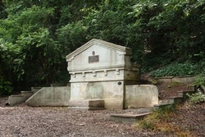
In Memory of
the Confederate
soldiers who lost
their lives in
defense of Aiken,
Feb. 11, 1865
Erected by the Memorial
Association 1911
— — Map (db m88573) HM
"Aiken Needs a Library Building."
Aiken had a subscription library as early as the 1870s but it was a floating library moored in private homes, stores, and downtown buildings. There was no permanent building and this lack became a rallying . . . — — Map (db m239078) HM
(panel 1)
The Cold War and Civil Defense in the Atomic Age
Where you are standing is the location of the Aiken Municipal Fallout Shelter. This underground shelter, constructed in the 1960s, was designed to provide an emergency . . . — — Map (db m239212) HM
Dining cars did not become standard equipment on railroads until after the Civil War. Before food was served on trains, meal options for passengers were less than appetizing. Roadhouses near regular train water-stops offered a limited selection of . . . — — Map (db m238826) HM
This church, founded in 1858 with 14 charter members and W. Peronneau Finley and John D. Legare as elders, first met in the Aiken Town Hall on Laurens St. Its first permanent sanctuary, a frame building designed by Charleston architect Edward . . . — — Map (db m29274) HM
He was first elected to the Aiken City Council in November 1985 and was appointed mayor pro tempore two years later. He was elected mayor in 1991 and served for 24 years, retiring in 2015.
While serving as mayor, he was the chair of Aiken's . . . — — Map (db m239213) HM
A sesquicentennial memorial gift to the city of Aiken by the family of Thomas H. Williamson (1888-1962), former county treasurer, member of the Aiken County Historical Commission and direct descendant of this cabin's builder. — — Map (db m102353) HM
(Front)
This is one of the oldest historically Black churches in Aiken. It was organized in 1866 by formerly enslaved members of Aiken First (Front) Baptist Church. They were led by their first pastor. Rev. John G. Phillips, who was . . . — — Map (db m239072) HM
(Front)
The turn-of-the-century barn to the south is a notable example of eclectic Victorian, brick, U-shaped barn design and construction. It has a rare working early 20th century carriage lift. In 1909, David W. Gaston, Sr. (1860~1931) . . . — — Map (db m239219) HM
Mayor
1946 - 1952
1957 - 1991
His office was our city's sidewalks and storefronts, and from his walks about the downtown he gained the information needed for leadership.
He was an advocate for harmony and teamwork, regardless of . . . — — Map (db m15136) HM
The Highland Park Hotel, Aiken’s first grand tourist hotel, stood atop this plateau. It was built in 1869-70 and opened in 1870. A four-story Second Empire wing built in 1874 doubled its capacity to 350 guests. Open from November to June, it . . . — — Map (db m29974) HM
Hitchcock Woods, one of the largest urban forests in the United States, is an area consolidated between 1891 and 1898 by Celestine Eustis (d. 1921), Thomas Hitchcock (1860-1941), and William Whitney (1841-1904). Described as "the greatest equine . . . — — Map (db m9776) HM
Josef Casimir Hofmann, internationally
known Polish pianist, resided with his
wife, Aikenite Marie Eustis Hofmann, in
a three~story house located several
hundred feet west of here. Born near
Cracow, Poland, he was recognized as a
gifted . . . — — Map (db m10184) HM
The steam engine had a dramatic impact on the development of transportation and industry in the 19th century. Indeed, it was the steam engine that powered the industrial revolution.
How does a steam engine work? The principal is simple. Water . . . — — Map (db m238827) HM
Lawmaker
Supreme Court Justice
"Assistant President"
Secretary of State
Peacemaker
Governor
Citizen of Aiken, 1900-1926
He gave a lifetime of service to state, nation, and the world. — — Map (db m15133) HM
(Front)
This is the site of Kalmia, the home and plantation of William Gregg (1800-1867), pioneer industrialist of the antebellum South. A native of Va., Gregg moved to S.C. in the 1820s, becoming a craftsman and merchant in Columbia and . . . — — Map (db m238816) HM
One of the oldest houses in Alken, this was home to the Legare family, including writer James Mathewes Legare (1823-1859), who lived here beginning in 1846. Portions of the house date to as early as 1837. The south wing was built c. 1852 as a . . . — — Map (db m213324) HM
This church, formally organized in 1884, had its origins in a Sunday school class organized in 1874. With 16 charter members and Rev. Arthur Buist as its first minister, Millbrook built its first sanctuary here in 1886. The frame church, built by . . . — — Map (db m38281) HM
The town of Aiken, on land donated by Mr. Beverly M. Rodgers to the S.C. Rail Road in 1834, was laid out around a core of 27 city blocks bounded by Edgefield and Park Aves. and Newberry and Williamsburg Sts. This area was surveyed by civil . . . — — Map (db m29613) HM
(Front text)
This plantation house, first known as “Edgewood,” is an excellent example of Federal-era architecture. Originally near Edgefield, it was built in 1828 for Francis W. Pickens (1807-1869), state representative and . . . — — Map (db m43154) HM
Savannah River Site
Aiken, South Carolina
Space voyages are among the most inspiring and iconic endeavors of the 20th century, yet practical realities have limited spacefaring ambitions. Providing electricity and heat to a spacecraft in . . . — — Map (db m214812) HM
Named in 1985 by action
of the Aiken County
Legislative Delegation
and Highway Commission
in recognition of an
outstanding citizen and
his many contributions
to the life and well being
of his county, district.
and state
2nd . . . — — Map (db m44725) HM
This school was founded by the Freedmen's Bureau shortly after the Civil War to educate freedmen, women, and children. In 1868 Martha Schofield, a Quaker from Pennsylvania, came to Aiken and began her long career as superintendent. The school soon . . . — — Map (db m28821) HM
Began first successful scheduled steam railroad service in America on December 25, 1830, and by 1833 its 136 miles from Charleston to Hamburg made it the world’s longest railroad. Now part of Southern Railway System. — — Map (db m9999) HM
This church has its origin in 1825 as a Methodist congregation on the Hollow Creek Circuit that predates the city of Aiken. Rev. John Reynolds was the
first circuit rider serving St. John's, which shared a minister with St. John in Graniteville . . . — — Map (db m10163) HM
This Episcopal Church (cornerstone laid Sept. 5, 1842) was consecrated Aug. 9, 1843. It is the city’s oldest church structure, having retained its Greek revival style through subsequent remodeling. Church purchased bell in 1853, Cornish Memorial . . . — — Map (db m19634) HM
(Front)
The Augusta and Aiken Railway, a 26-mile interurban electric trolley line between Augusta, Ga., and Aiken, operated from 1902 to 1929. In Aiken the line began at the corner of Park Ave. & Union St., proceeded west on Park, then . . . — — Map (db m239218) HM
The Detection of the Neutrino, 1956
On August 27, 1956, at the Savannah River Plant (now Savannah River Site), Drs. Clyde L. Cowan, Jr. (1919-1974) and Frederick Reines (1918-1999) used P Reactor to detect the neutrino, a sub-atomic particle . . . — — Map (db m43146) HM
Originally located in China Springs, near Aiken, and believed to have been built in the 1890's this schoolhouse was given to the Aiken County Historical Commission by Mrs. Guerin Hermann of Sandersville, Georgia in 1975.
The one room . . . — — Map (db m63475) HM
The tracks of the S.C. Railroad, operated by the S.C. Canal & Railroad Company, ran here from 1833 to the 1850s. The company, chartered in 1827, began constructing a 136-mile long line from Charleston to Hamburg (near North Augusta) in 1830. . . . — — Map (db m36676) HM
Iron heliometer tower, which served as an observatory, and housing for instruments, including powerful telescopes, used in viewing the December 6, 1882, Transit of Venus in Aiken, South Carolina. The observatory was built in two sections, each . . . — — Map (db m10193) HM
For many years, the water trough was located behind the County Courthouse. The following are to be commended for their efforts in restoring and re-establishing the trough as its new location on South Boundary.
Aiken County Historical Commission . . . — — Map (db m102364) HM
(Marker Front)
This park, laid out in 1904-05 was named for William Collins Whitney (1841-1904). Whitney, a lawyer, Secretary of the Navy 1885-1889 under Grover Cleveland, and financier, was also an avid sportsman and leading member of the . . . — — Map (db m10210) HM
URS Corporation on the occasion of the City of Aiken's 175th year, graciously donated this symbolic representation of William Aiken Sr. (1779-1831), for whom the city was named in 1835. Aiken was an entrepreneur and president of the South Carolina . . . — — Map (db m86825) HM
(West Face)
This Memorial is erected
in the memory of deceased
members of the Woodmen
of the World whose
Individual resting places
could not be marked
(East Face)
Woodmen of the World
Regional Memorial
(List of . . . — — Map (db m10270) HM
German prisoners of war were held in a camp on this site from November 1943 to May 1946. This camp, one of 21 in S.C., was at first a sub-camp of the POW camp at Camp Gordon (now Fort Gordon), in Augusta, Ga. It was later a sub-camp of Fort . . . — — Map (db m36396) HM
(side 1)
Sustained Jewish settlement in Aiken dates to the 1890s. By 1920, a concentration of Jewish-owned businesses had opened along this section of Laurens Street and other streets nearby. The first known Jewish merchant in Aiken was . . . — — Map (db m225550) HM
On January 5, 1856, Governor James H. Hammond and eleven other farmers of this area organized the Beech Island Agricultural Club for the diffusion of agricultural knowledge and the regulation of illegal slave traffic. Monthly meetings and . . . — — Map (db m10080) HM
This church was organized in the Beech Island Academy on January 21, 1832, with Rev. Iverson Brooks as its first minister and Mathias Ardis and Randolph Bradford as its first deacons. This sanctuary, built on land donated by James T. Gardner . . . — — Map (db m9992) HM
Downer Institute & School
Downer Institute, founded in 1843, was originally located 1.5 mi. NE of this site and operated until 1865. It was named for benefactor Alexander Downer (1752–1820), whose will established an orphanage and school . . . — — Map (db m9994) HM
This church was built in 1836 by Beech Island Presbyterian Church, organized in 1827 with the Rev. Nathan H. Hoyt of Vermont as first pastor. His son-in-law the Rev. Edward Axson, was ordained and served here. His daughter, Ellen, wife of Woodrow . . . — — Map (db m9909) HM
About Redcliffe Plantation State Historic Site
Redcliffe Plantation was the home of James Henry Hammond (1807-1864) and three generations of his descendants. Hammond whose political career included terms as a United States Congressman, . . . — — Map (db m9591) HM
Savannah Town
Forerunner of modern towns and highways and known to the English as early as 1685, this Indian town stood at a major northwestern entrance into S.C. on the trading routes to the Creeks, Choctaws, Chickasaws, and Lower Cherokees. . . . — — Map (db m28101) HM
(Front text) This church had its origins at or near this site in 1772 as a plantation chapel, in what was Edgefield District until after the Civil War. Revs. Iverson L. Brookes and John Trapp, prominent ministers in the Savannah River . . . — — Map (db m31141) HM
This house was for many years the home of Marie Cromer Seigler (1882-1964), educator and national pioneer in agricultural instruction. In 1910, as teacher and principal of Talatha School, she founded a Girls' Tomato Club, the first of many such . . . — — Map (db m28714) HM
1776 1976
In memory of the
200th Anniversary of the
United States as an
Independent Nation
and American Patriots
who fought for the freedoms
we now enjoy
Erected by the Towns of
Graniteville, Vaucluse and
Warrenville . . . — — Map (db m9852) HM
This bell was used at the Graniteville Company Farm for many years in the late 1800’s to call the workers from the fields at noon, and also was rung to signal emergencies. It was preserved, cared for and made available to the LEISURE YEARS CLUB in . . . — — Map (db m238813) HM
(Front)
This Carpenter Gothic school was built in 1848 by the Graniteville Mill, then the largest textile mill in S.C. William Gregg (1800-1867), who opened the mill in 1847, created a model mill village here. This academy, with five . . . — — Map (db m238811) HM
(Front text)
This cemetery, established about 1850, is closely associated with the Graniteville Mill, the largest and most
successful textile mill in antebellum S.C. William Gregg (1800-1867), founder of the mill, laid out the mill . . . — — Map (db m43153) HM
This mill, the largest textile mill in antebellum S.C., was chartered in 1845 and opened in 1847. It was founded by William Gregg (1800–1867), a Virginia native and advocate of industrial development who chose this site for its proximity . . . — — Map (db m9763) HM
(Bottom of Center Panel):
Greater love hath no man than this, that a
man lay down his life for his friends.
John 15:13
(Marker Left Panel):
At 2:39 am on January 6, 2005 . . . — — Map (db m10798) HM
(Front)
This Classical Revival school, built by the Graniteville Mill in 1921-22, was designed by noted Augusta architect Willis Irvin (1890-1950) and was called “the finest school in the state” when it was dedicated. An elementary and high . . . — — Map (db m238809) HM
Situated between this point and the Savannah River, Hamburg was a thriving river port and trading center for cotton and tobacco. Founded in 1821 by Henry Schultz, incorporated December 19, 1827, Hamburg became the most important interior port in . . . — — Map (db m41892) HM
Near the foot of this bluff in the old town of Hamburg stood the western terminus of the S.C. Canal and Rail Road Co. Begun in 1830, it was the first steam operated railroad to offer regular passenger service and to carry U.S. mail. Completed in . . . — — Map (db m27835) HM
This church, one of the first black Baptist churches in America, grew out of regular worship services held as early as the 1750s at "Silver Bluff," the plantation of Indian trader George Galphin. At first a non-denominational congregation with . . . — — Map (db m31610) HM
Post office est. here 1873. Town chartered 1880. Ellenton and surrounding area purchased by US Govt in early 1950s for establishment of Savannah River Plant. — — Map (db m9910) HM
Pascalis Plantation
Elizabeth Pascalis purchased these 790 acres in 1835, settled here with her son Cyril Ouviere, and brought the orphaned children of her daughter, here, to live. Cyril, a civil engineer, was a resident engineer . . . — — Map (db m9797) HM
This is the site of Camp Butler, a
Confederate "camp of instruction"
that operated from the spring to
the fall of 1861, in what was then
Barnwell District. New companies,
organized as independent companies,
or in state regiments, were . . . — — Map (db m63281) HM
Fifty Years ago today, November 28, 1950, President Harry S. Truman announced that the Savannah River Plant would be built. This marker is dedicated to families who originally lived on this property and to the patriotic men and woman who have made . . . — — Map (db m10001) HM
The Savannah River Plant (SRP) was built 1950–56 by Du Pont for the Atomic Energy Commission. SRP, a nuclear production plant, produced tritium and plutonium for national defense during the Cold War. Creating a 310-sq.-mi. site in three . . . — — Map (db m9941) HM
(Front)
This African-American community was established in 1930 after two floods on the Savannah River washed away most of the town of Hamburg. That town had become a predominantly African-American community after the Civil War. Carrsville . . . — — Map (db m238689) HM
Former location of the WJ Rutherford & Co brick manufacturing yard established circa 1895-1896 in Hamburg, SC. In addition to manufacturing high quality brick the company were dealers of lime, cement, roofing, etc. The clay used to manufacture the . . . — — Map (db m238710) HM
Hamburg, located in the surrounding area, was a thriving river port and trading center for cotton and tobacco. Founded in 1821 by Henry Shultz and incorporated on Dec. 19, 1827, Hamburg became the most important interior port in S.C. With changing . . . — — Map (db m238700) HM
The Hampton Terrace Hotel, an exclusive winter resort, stood atop this hill from 1903 to 1916. The $536,000, 5-story hotel boasted more than 300 rooms and was the dream of James U. Jackson (1856-1925), founder of North Augusta. A private . . . — — Map (db m31103) HM
James U. Jackson Memorial Bridge
The first North Augusta bridge was built in 1891 by James U. Jackson. The present bridge, built in 1939, was formally dedicated as "The James U. Jackson Memorial Bridge." The building of the 1891 bridge, the . . . — — Map (db m31662) HM
James Urquhart Jackson, founder of North Augusta, was born in the village of Harrisonville, near Augusta, Georgia, on June 24, 1856. It was his vision that shaped North Augusta's early years.
In 1890 Jackson acquired 5600 acres of land . . . — — Map (db m10050) HM
Korea
1950 — 1953
Dedicated to the men
and woman who bravely
fought in "The Forgotten
War". The first war to
end the spread of
communist tyranny
throughout the world. — — Map (db m31364) WM
(South face):
Dec. 4,1852 - July 8, 1876
———
In Memory of
Thomas McKie
Meriwether.
Who on 8th July 1876,
gave his life that the
civilization builded by his
fathers might be preserved
for their . . . — — Map (db m10170) HM
Mexican War
1846 — 1848
Dedicated to the brave men of
South Carolina who along with
other Patriots willingly
served that the Nation might
expand its western horizons.
Of these men who willingly
volunteered to fight a . . . — — Map (db m30980) WM
North Augusta, chartered in 1906, includes the site of two early towns. Campbell Town was a trading post on the Savannah River before the American Revolution. Hamburg, founded in 1821 as a port on the river, was an early western terminus of the . . . — — Map (db m9672) HM
The City of North Augusta was commissioned in 1906, but construction of the industrial district began earlier, in the 1890s. Factories and industrial properties were located in the bottomlands, while residential areas lined the hills overlooking . . . — — Map (db m238833) HM
Since the late 1700s, the Edgefield District, located in present-day Aiken and Edgefield Counties, was well known for the production of distinctive pottery. Known as alkaline-glazed stoneware because of its characteristic glaze and the hardness of . . . — — Map (db m238837) HM
(Front)
Providence Baptist Church was established by enslaved and free people of African descent in the town of Hamburg. After the Civil War Hamburg became a center of African American political power in Aiken County. In 1868 three members . . . — — Map (db m238687) HM
Our fight for Independence
that assured us Freedom of
Speech, Religion, the Press,
Right to Peaceful Assembly
and right to Petition for
Redress of Grievances. We
enjoy our present freedom
because of the willingness
of our . . . — — Map (db m30819) HM
Born 1757 in Virginia, this Indian fighter, who later moved to Edgefield District, attained the rank of Lieutenant Colonel of state troops during the American Revolution. Among the engagements he participated in were: Hanging Rock, Musgrove’s Mill, . . . — — Map (db m9800) HM
"Soul Music Queen" Rhythm & Blues Legend The Sharon Jones story begins and ends in North Augusta. Born May 4, 1956, she lived in North Augusta during her early years. She first sang publicly as an angel in a Christmas pageant at North . . . — — Map (db m234319) HM
Spanish American War
1898
The battle with the
slogan "Remember the
Maine", brought the
United States as a
great power and the
beginning of overseas
recognition. — — Map (db m31208) WM
(Front)
The Hamburg Massacre, which occurred nearby on July 8, 1876, was one of the most
notable incidents of racial and political violence in S.C. during Reconstruction. White Democrats across the state organized “rifle clubs” to . . . — — Map (db m238696) HM
In the 1730s, an Indian path from Fort Moore to the Saluda ridge was used by traders going to the Cherokee Nation. Later, a wagon road from Ninety Six to Augusta followed the same route. Named for the Martin family who lived beside it and served . . . — — Map (db m203774) HM
War Between The States
1861 — 1865
Let the stranger who may in
future times read this
inscription recognize that
these were men whom power
could not corrupt, whom death
could not terrify, whom
defeat could not dishonor, . . . — — Map (db m31127) WM
World War I
1914 — 1918
Dedicated to the men
and women who served
in the great war which
was believed to be the
final war of human
liberty and the "war to
end all wars". — — Map (db m31243) WM
World War II
1941 — 1945
Dedicated to the men and women
who battled globally to
secure a free world for
all mankind. The massive
production war effort caused
many women to enter industry
and changed the American . . . — — Map (db m31269) WM
This park is constructed in honor of Charles Boeckh, civil engineer, who was commissioned in 1891 by city founder, James U. Jackson, to lay out the town plan for North Augusta. — — Map (db m196767) HM
For more than 10,000 years, people have lived along the Savannah River. Stone spear points and tools have been found along both the South Carolina and Georgia shorelines, indicating a long history of hunting and gathering. The earliest pottery in . . . — — Map (db m240333) HM
About 1,000 years ago Native Americans settled at this location. We know these people as the Mississippians, and they lived throughout the Southeast and the Mississippi Valley. They built large villages and ceremonial earthworks along major rivers. . . . — — Map (db m238988) HM
By the time the first Europeans settled in the North Augusta area in the early 1700s, it was clear that the Savannah River was both their livelihood and their connection to the outside world. They fished the river, as their Native American . . . — — Map (db m239494) HM
Commemorative
In Recognition of those of
Perry serving in the
U.S. Armed Forces
and in memory of those
who lost their lives.
Erected Oct. 8, 1988 — — Map (db m50340) WM
(obverse)
Indian Head
The Indian Head, a series of springs at the head of Goodland Swamp, long served as a landmark and watering place. Travelers along the Middle Road referenced it and it appears on colonial plats. In 1781 . . . — — Map (db m102914) HM
(Front)
A patriot and Christian
devoted to his country, his
family and his god.
He served his country well
as a member of Hart's Battery
and died loving the cause
for which he fought.
Dempsey Hammond Salley was
. . . — — Map (db m47645) HM
(Front) The congregation of Zion Hill Missionary Baptist Church originated c.1894, when
tradition holds that members began worshipping at a brush arbor across the road. Rev. James
Turner was the first pastor. Early church leadership included men . . . — — Map (db m239261) HM
4589 entries matched your criteria. Entries 101 through 200 are listed above. ⊲ Previous 100 — Next 100 ⊳