On S. Electric Ave. near West 1st Street, on the right when traveling south.
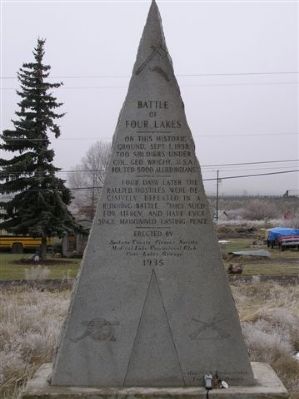
On this historic ground, Sept. 1, 1858, 700 soldiers under Col Geo. Wright, U.S.A. routed 5,000 allied indians.
Four days later, the rallied hostiles were decisively defeated in a running battle. They sued for mercy, and have ever since . . . — — Map (db m3816) HM
On South La Prairie Town Hall Road, 0.5 miles south of East Avalon Road, on the right when traveling south.
La Prairie Grange No. 79 was organized February 27, 1873, and the Grange Hall was built between June 20 and September 5, 1874. Constructed jointly with the Town of La Prairie, the Hall cost $1,938.50.
In 1960 the Town Board deeded the land and . . . — — Map (db m40478) HM
On State Highway 83 at Lost Lake Drive, on the right when traveling south on State Highway 83.
Panel 1
Russellville
For a few exciting months, Russellville felt like Colorado's gold-rush capital. The town rose five miles southeast of here in late 1858, after William Green Russell discovered a few gleaming . . . — — Map (db m97969) HM
On East Colorado Street east of North College Street, on the right when traveling east.
From the time of the first European settlers in Texas, yellow fever was a serious concern. Transmitted through mosquitoes, epidemics in the summer months were prevalent in coastal cities all over North America in the nineteenth century. At the time, . . . — — Map (db m109026) HM
On West Cottage Grove Road (County Highway Bb) 0.5 miles west of Main Street (County Highway N), on the left when traveling west.
The Cottage Grove Grange, which became a leader in the state and national Grange movement, had its meeting hall near this site shortly after the Civil War. As a community center it became a significant cultural and social influence for pioneer farm . . . — — Map (db m37290) HM
On Monterey Road, on the right when traveling north.
The town of Coyote was established on a popular route known as El Camino Real by the Mexicans who traveled it. This route linked the missions throughout California. Originally named Burnett, Coyote developed around a post office that was housed in a . . . — — Map (db m207448) HM
On Main Street at 4th Street, on the right when traveling south on Main Street.
Van Buren Township was organized out of Huron Township by an act of the Legislative Council of the Territory of Michigan in 1835. Township business was conducted from homes until this building was completed in 1875. The original plans called for a . . . — — Map (db m98876) HM
Near Ontario Center Road, 0.2 miles south of Brick Church Road.
[left panel]: Map of Phelps & Gorham’s Purchase 1790. In 1776, at the start of the Revolutionary War, the Iroquois Indians held claim to this territory. In 1788, Oliver Phelps of Connecticut, and Nathanial Gorham of Massachusetts purchased 2,600,00 . . . — — Map (db m172822) HM
Near W. 50th Street east of Browndale Avenue, on the right when traveling east.
The Place Where People Want To Go
Back in the late 1900s, farmland stretched along this area below the Edina Mill dam. The pastoral landscape—with its intersection of the creek, grassy fields and woods—became a popular destination. Swimming . . . — — Map (db m198304) HM
On Rue de la Grange Batelière at Passage Jouffrey et Verdean, on the left when traveling west on Rue de la Grange Batelière.
La Grange Batelière était au Moyen-Age une ferme fortifiée (Grange Bataillée). Son nom fut donné plus tard à un petit course d'eau qui disparut vers la fin du XVIIIème siècle. Au n°10 de la rue fut édifié sous Louis XV l'hôtel de Biéville ou de . . . — — Map (db m85283) HM
On Parkdale Drive at Rogue River Hwy (U.S. 66) on Parkdale Drive.
On this site in 1916, the Oregon Utah Sugar Company erected a large beet factory. C.W. Nibley, director of the company and presiding bishop of The Church of Jesus Christ of Latter-day Saints (Mormons/L.D.S.), oversaw the project. Nibley's sons, . . . — — Map (db m112529) HM
On Cloverdale Road, on the left when traveling south.
The townsite is located along Cloverdale Rd. for 0.7 of a mile. Established in 1849, the town grew quickly to 1,500 residents, including 600 Chinese closeby. The Hardscrabble mine began operations in 1853, served by the Dry Creek Tunnel and Fluming . . . — — Map (db m89136) HM
On N. Main Street north of Maple Street, on the left when traveling north.
(Tablet facing East)
First rural free delivery carriers starting out from Climax post office. (From photo taken by Frank Hoogman)
This tablet erected by Michigan Rural Letter Carriers' Association, 1917.
(Tablet facing . . . — — Map (db m221660) HM
On W. Main St at Pleasant St, on the left when traveling west on W. Main St.
(Front Side)
Seville's most famous residents, Captain Martin Van Buren Bates (1845-1919) and Anna Swan Bates (1848-1889) settled here in 1873. Their notoriety stemmed from their dramatic stature: Martin, a former Confederate soldier from . . . — — Map (db m61959) HM
On Pawling Street, on the right when traveling south.
Has Been Placed on The
National Register of
Historic Places in 2002
By the United States
Department of the Interior
William G. Pomeroy Foundation 2013
— — Map (db m76606) HM
On Roberts Ferry Road, 0.2 miles south of Yosemite Boulevard (California Highway 132).
[A short walk starting on the eastern side of the Roberts Ferry Covered Bridge; walking south, crossing over to the western side and returning north. Interpretive markers are placed along both sides covering the timeline from the first people who . . . — — Map (db m42617) HM
On Port Tobacco Road (Maryland Route 6) 0 miles east of Walnut Hill Road, on the right when traveling east.
Dr. James Craik, friend and family physician of Gen Washington, built this place, La Grange, about 1765 and lived here until his removal to Alexandria, VA., 1783. — — Map (db m6734) HM
On North Dean Street at East Hunt Street, on the right when traveling north on North Dean Street.
The Agricultural Society of Lenawee County organized and held its first fair in 1839, making it one of Michigans oldest county fairs. The fair originally took place in downtown Adrian between River Street and the River Raisin. In 1879 the grandstand . . . — — Map (db m102733) HM
On West Main Street (U.S. 20) at Forest Place, on the right when traveling east on West Main Street.
Near here on April 16, 1868, farmers organized the first grange to champion their needs in the healing of the nation recovering from civil war. — — Map (db m96226) HM
Farming & industrial community dating from 1800 with a school, blacksmith, grange hall, factories & mills. Chadwick Tavern built 1830. — — Map (db m58049) HM
On Peekskill Hollow Road at Church Road, on the right when traveling south on Peekskill Hollow Road.
Adams Corners was a community centered around an 1846 school, 1900 Grange Hall, general store, and town’s first telephone exchange. — — Map (db m212122) HM
On Chaffee Road (County Road 54) at Curriers Road (County Road 44), on the right when traveling west on Chaffee Road.
Built 1900, served as school until 1969. Curriers Grange No. 1273 held meetings and events in second floor hall, acquired building in 1970. — — Map (db m203694) HM
On Rose Way Circle, on the right when traveling north.
Before migrating to Texas, A. J. Rose made a fortune in the 1849 California Gold Rush. In 1857 he and his wife Sallie (Austin) brought their family from Missouri to Travis County, Texas. Later they settled in San Saba County, where Rose ran a mill . . . — — Map (db m29345) HM
On North College Street north of East Travis Street (Business Texas Highway 71), on the right when traveling north.
Used for burials by 1840, this site was deeded by J. S. Lester to trustees who conveyed it to La Grange after incorporation of the city on July 3, 1854.
Fourteen townswomen on April 17, 1873, formed what was probably the first such organization . . . — — Map (db m84613) HM
On East Colorado Street at North Madison Street, on the left when traveling east on East Colorado Street.
In 1844, Georgia native William Graham Webb (1824-1902) immigrated to Texas and settled in La Grange. Soon after his arrival in Texas, Webb enlisted as a private during the U.S. - Mexico War, where he joined Jack Coffee Hays' Regiment of the Texas . . . — — Map (db m183175) HM
On South 4th Street at Marion Street, on the right when traveling north on South 4th Street.
Side A:
Here on the Mississippi, where wooded hills rise above the plains along the river, Edward White, Robert Sinclair, and Isaac Bland founded Canton, probably named for Canton, Ohio, in February of 1830. On the pioneer Salt River . . . — — Map (db m55407) HM
On Storer Street just north of Berry Court, on the right when traveling north.
This home was constructed in 1758 by Joseph Storer and his wife Hannah. Storer was the wealthiest man in Kennebunk at the time and owned a saw mill, country store and grist mill. He entered into the Revolutionary War in 1777. He was . . . — — Map (db m186308) HM
On North Main Street at West Pearl Street, on the left when traveling north on North Main Street.
German native Dr. William A. Hermes moved to La Grange in 1855 to practice medicine. He opened Hermes Drug Store the following year with his partner, Dr. Eck. His two sons, August and William, Jr., earned pharmacy degrees and joined the family . . . — — Map (db m71627) HM
On North Ector Drive, 0.1 miles north of West Airport Freeway (Texas Route 121).
Elisha Adam Euless (1848-1911) migrated to Texas in 1867 from Bedford county, Tennessee and settled in Tarrant
County. In July 1870 Euless married Judy Ann Trigg, also a Tennessee native. He began farming and bought land in 1871. Euless was . . . — — Map (db m228320) HM
On L Drive North, 0.4 miles west of 13 Mile Road, on the right when traveling west.
This farm has remained in the Bryant family since 1844 and retains much of its original Civil War era appearance. The ruins of stone fences erected without mortar still stand as a rare reminder of early settlement. Mary Bryant Mayo (1845-1903), . . . — — Map (db m178045) HM
On North Washington Street at West Colorado Street, on the right when traveling north on North Washington Street.
220 & 222 North Washington 164, 160, 152 & 148 West Colorado Winter 1888
As early as the 1840's a frame building stood on this site serving as a hotel under many different names including the Eagle Hotel, Carter Hotel, La Grange Hotel, . . . — — Map (db m183159) HM
3000 BC - The first Amerindian people settle in the bay. Les premiers Amérindiens s'installent dans la baie. 1493 - One ship of Columbus fleet on his 2nd Voyage enters the bay and sees dwellings and people. Un navire de la flotte de Christophe . . . — — Map (db m94478) HM
On Cypress Street near North Main Street, on the right when traveling west.
Originally located at another Main Street site, Valley Mercantile move into the old Grange Hall at this corner around 1910. The owner, Joseph Silviara, replaced the wood structure with a brick building in 1916. In addition to its retail business, . . . — — Map (db m93876) HM
Possibly named for John Grange Green, pioneer Shreveport property owner and friend of Capt. Shreve, or for Dr. William Mercer Green, who was killed in a duel in this alley, just north of Texas Street, in 1849. South of Texas St. the alley is called . . . — — Map (db m109743) HM
On Division Street (Old U.S. 27) at East Washington Street, on the right when traveling north on Division Street.
On this site lived Cyrus Gray Luce, twenty-seventh Governor of Michigan. Born in Ohio in 1824, he moved to Branch County about 1849. He soon became involved in township, local and state politics, serving on the Board of Agriculture, in the . . . — — Map (db m66760) HM
On North Scott Road at West Marshall Road, on the right when traveling south on North Scott Road.
The Reverend William Benson organized a Methodist class for this area in 1849. The class, which had seven members, held its first worship service in a log school south of Eureka. Later it met in the Sherwood School and the Keystone Grange Hall. . . . — — Map (db m217225) HM
On North Territorial Road east of Lakeshore Drive, on the right when traveling east.
The Reverend Charles Glenn organized the first Methodist class here in 1836, and for the next ten years the group met in the home of his brother, John. In 1846 the brothers presented the congregation with a building which served as both church and . . . — — Map (db m211045) HM
On U.S. 10, 0.8 miles east of Cleveland Street, on the right when traveling east.
Itasca grew up around an Indian trading post which was established 800 feet east of here in 1849 by Thomas A. Holmes and James Beatty. At the suggestion of Territorial Governor Alexander Ramsey, the settlement was named in honor of Lake Itasca, the . . . — — Map (db m69908) HM
On Lafayette Street, on the left when traveling north.
These four houses constitute the remaining portion of a colonnade of nine, originally named La Grange Terrace after the country seat of the Marquis de Lafayette. When constructed in 1831 by Seth Geer, this was considered the finest row of private . . . — — Map (db m41192) HM
On Youngstown Lockport Road (New York State Route 93) 0.1 miles west of Ransomville Road, on the left when traveling west.
c. 1902, John and Henry Swigert built an evaporator, one of the world's largest apple dryers, and in 1905 a cooperage. Both were destroyed by fire in 1927. The Grange Hall survived. — — Map (db m72712) HM
On Broadway Ave. north of Montauk Hwy, on the right when traveling south.
The stucco cottage was built by George Robinson and was located on the northwest corner of Main and Greene Streets in Sayville. Used by Lillian Robinson as a real estate sales office and as the Bicentennial Cottage in 1976. This location was used . . . — — Map (db m123419) HM
Near Broadway Ave. north of Montauk Hwy, on the right when traveling south.
This Greek-Revival structure was built by Captain Benjamin Tuthill in 1850 and was located in Sayville, NY. It was sold to John F. and Lizzie Case in 1907. Lillian Robinson purchased it from Case descendents in 1946. The house was donated to Islip . . . — — Map (db m123420) HM
On Old State Route 74 west of Werner Lane, on the right when traveling west. Reported missing.
Built by Cyrus Broadwell, this building housed a public school, 1857-1866, and Mt. Carmel Grange, 1876-1966. The Junior Order, the I.O.O.F., and a church once met here. The building was sold to a business in 1973. — — Map (db m204899) HM
On Main Street at 5th Street, on the right when traveling south on Main Street.
Prisoners convicted of rioting, larceny and adultery in Morgan County between 1833 and 1839 were confined to a dungeon near the Court House in McConnelsville. This stone vault, 11 feet high, 5 feet wide and 12 feet long, was discovered in 1964 and . . . — — Map (db m13388) HM
On Williams Grove Road, on the right when traveling south.
With its excellent railroad connection, this became the site of the Great Grangers' Interstate Picnic Exhibition, founded 1874 by Robert H. Thomas of the Pennsylvania State Grange. A week's attendance at this annual event was estimated at 100,000 or . . . — — Map (db m169216) HM
On Rose Way Circle, on the right when traveling north.
Built in 1870-72, this structure typifies the Greek Revival style with its symmetrical facade. The residence was constructed for former Confederate officer Archibald Johnson Rose (1830-1903) and his large family. A prosperous farmer, Rose . . . — — Map (db m29346) HM
On Austin Highway (State Highway 368) at Corrine Drive, on the right when traveling south on Austin Highway.
Occurred in this vicinity on September 18, 1842 when Captain Nicholas Mosby Dawson and 53 men from La Grange, in attempting to join Captain Mathew Caldwell (Old Paint) and his company of Texas volunteers during the Battle of the Salado, were . . . — — Map (db m85981) HM
South Carolina native John M. Crockett married Katherine (Kate) Polk in 1837. In 1848 they moved to Dallas where Crockett opened one of the pioneer settlement's first law offices. Crockett served as a State Legislator, Mayor of Dallas, and . . . — — Map (db m159719) HM
On North College Street north of East Travis Street (Business Texas Highway 71), on the right when traveling north.
Although voted 600 against to 580 for secession, began Confederate recruiting in June 1861. La Grange was headquarters for 22nd Brigade, Texas State Troops, Brig. Gen. Wm. G. Webb commanding, of which 18 companies (1,238 men ) and 72 officers were . . . — — Map (db m84614) HM
On North Main Street north of West Lafayette Street, on the left when traveling north.
Built about 1828 - used as a place of defense against the Indians and known as Moore's Fort in honor of its builder and owner, John Henry Moore, 1800-1880, noted Indian fighter and commander of the Texans at the Battle of Gonzales, October 2, 1835 - . . . — — Map (db m53228) HM
On Cheek Sparger Road at Horizon Drive, on the left when traveling west on Cheek Sparger Road.
The first permanent settler to this area was Samuel Cecil Holiday Witten of Spring Garden, Missouri, who came here in 1854. In 1865, with Milton Moore, he built a schoolhouse here which was named for his Missouri home. The building also served as a . . . — — Map (db m227333) HM
On Pleasant Run Road at Shelton Drive, on the left when traveling south on Pleasant Run Road.
The Baptist Church of Christ of Pleasant Run was organized on April 7, 1877, by a presbytery consisting of J.Q. Barnett, L.H. Foster, A.J. Hallford and M.J. Mills. The congregation met at first in the one-room Grange Hall or Lodge in what became . . . — — Map (db m192650) HM
On Hinman Settler Road at Old Stone House Road, on the left when traveling north on Hinman Settler Road.
The Brownington Village Historic District was added to the United States National Register of Historic Places on June 9, 1973. The district consists of seven buildings within the Old Stone House Museum complex as well as the Brownington . . . — — Map (db m221753) HM
On Old National Pike (Maryland Route 144), on the right when traveling west.
Here at Milestone 31, about 130 feet southeast of its original location, the Baltimore and Frederick-Town Turnpike created two towns as it moved west. Both Parrsville and Ridgeville are now a part of Mount Airy. Parrsville, to the east, was . . . — — Map (db m4933) HM
On Cole Road west of East Miller Road, on the left when traveling west. Reported missing.
Archaeological evidence indicates men lived in this area before the time of Christ. Chippewa Indians settled here sometime before 1790. Their village was called Kechewandaugoning, which is said to mean "Big Salt Lick." This was the birthplace of . . . — — Map (db m145955) HM
On West Columbia Road, 0.2 miles east of County Road 7, on the right when traveling east.
Side 1
Newville Baptist Church
A small Baptist congregation met under a brush arbor in 1876, near what later became the village of Wells which grew into the town of Newville, Alabama. A log church called Center was erected in . . . — — Map (db m71814) HM
On North Broad Street (Alabama Route 173) 0.1 miles south of North Railroad Street (County Road 7), on the left when traveling south.
Newville High School
The first known school in Newville was at Center Church in 1881. When Grange Hall was built in 1891, church services and school were held on the first floor. In 1913, Grange Hall was torn down and the wood was used to . . . — — Map (db m71812) HM
On Salt Point Turnpike (New York State Route 115) north of Firehouse Lane, on the left when traveling north.
Built By the Society of Friends --- 1777
A Committee Was appointed to “Pitch upon a place for the Meeting House” --- 1775
Preparative Meeting Allowed By Nine Partners --- 1776
Monthly Meeting Set Up -- 1782
Division of . . . — — Map (db m158874) HM
On South Main Street at West Crockett Street, on the left when traveling south on South Main Street.
When the Congress of the Republic of Texas established Fayette County in 1837, La Grange became its seat of government. A county jail was built in 1838 and used for ten years before it was sold. In 1853, the county purchased two lots in block 33 for . . . — — Map (db m183156) HM
On West Hempstead Street at South Dallas Street, on the right when traveling west on West Hempstead Street.
The La Grange Baptist District Association of Texas was organized in 1874. That same year, land was purchased in Giddings for a church that had recently been organized in a private home. A church building was soon erected, located south of the . . . — — Map (db m151372) HM
On Washington Street east of 1st Avenue (Kentucky Route 53), on the left when traveling east.
Home of Dr. Rob Morris, 1818-88. In 1884 "crowned Poet Laureate of Freemasonry." Founded the Order of the Eastern Star. He was born near Boston, Mass., lived 28 years here. From 1861 to 1865 president of the Masonic College, located in La Grange, . . . — — Map (db m96058) HM
The garrison at the Cabrits never saw any action, although the Battle of the Saints, fought between the French and British fleets on 12 April 1782, occurred within sight of the ramparts, and Fort Shirley was the scene of the revolt of the 8th West . . . — — Map (db m94501) HM
On Jackson Hill Road at Main Street (Route 157), on the right when traveling north on Jackson Hill Road.
Site Of
Old Town Hall
Land Purchased And
Given To Town In 1892 By
Members Of Middlefield
Grange For A Town Hall
Building Dedicated
And Used By Grange
Mar. 16, 1894 – June 6, 1964 — — Map (db m94843) HM
On Mount Idaho Grade Road at Whitetail Drive, on the left when traveling north on Mount Idaho Grade Road.
In 1862, a noted Western scout, Mose Milner, started Mount Idaho on his gold rush trail.
But when civic leaders resisted farm efforts to organize a grange there in 1874, Grangeville grew up as a better located town. Although Mount Idaho . . . — — Map (db m121317) HM
On Bratten Street just north of Main Street, on the left when traveling north.
This building began as local craftsman Thomas Windsor's backyard carpentry shop, just west of here on Main Street in the late 1800s Upon his death in 1901, the building was sold to Wicomico County and moved to its current location to be used for tax . . . — — Map (db m190292) HM
On Main Street just east of Church Street, on the right when traveling east.
In 1869 George Bounds and Thomas B. Taylor took the lead in building this church, and opened it in 1871. The center section was built first, and in 1906 an education wing was built on the east side. A new educational building with large kitchen and . . . — — Map (db m190263) HM
On Mendon Street (Massachusetts Route 140) at Thayer Road, on the left when traveling east on Mendon Street.
Original Town Common circa - 1898 The Bellingham Police Department now stands on the original green of the Town Common. The small building in the center was the town's lock-up facility which was erected in 1875. The two-room Massey School House . . . — — Map (db m195740) HM
On 7 Mile Road Northwest at Walker Avenue Northwest, on the right when traveling east on 7 Mile Road Northwest.
In 1847, Alpine Township was set apart from Walker Township at a meeting held in a schoolhouse in present-day Comstock Park. Edward Wheeler was elected supervisor. Subsequent meetings were held in a log school one-half mile east of here on the . . . — — Map (db m176424) HM
On West Nepessing Street at North Court Street, on the right when traveling east on West Nepessing Street.
Set off by Gov. Cass in 1822, this county took its name from the French La Pierre, a translation of the Indian name for the Flint River. Settlers began to arrive in 1828. The county seat, founded in 1831, was also named Lapeer. Organization . . . — — Map (db m101532) HM
On State Highway 32 at Beltz Road, on the left when traveling west on State Highway 32.
Natural features have often played a role in the naming of communities. One such settlement was Big Rock. Named after a massive boulder, this hamlet was located at the crossroads of present-day M-32 and Thornton Road. Seth Gillet became the first . . . — — Map (db m33279) HM
On Clove Road (County Route 653) at Millville Road, on the right when traveling south on Clove Road.
This hamlet acquired its name from the grist & saw mills built along Shimers Brook. The first mill lot was acquired in 1722 from Solomon Davis & Thomas Stephenson. Two grist mills existed by the Revolutionary War. Captains Abram Shimer & James . . . — — Map (db m160354) HM
On River Road (County Road 521) 0.1 miles north of Millville Road, on the left when traveling north.
This hamlet acquired its name from the grist & saw mills built along Shimers Brook. The first mill lot was acquired in 1722 from Solomon Davis & Thomas Stephenson. Two grist mills existed by the Revolutionary War. Captains Abram Shimer & James . . . — — Map (db m231583) HM
On Lake Avenue at LaBelle Avenue, on the right when traveling west on Lake Avenue.
Historic Lake Avenue ——·•·—— In 1884 a North Collins man, Heman Blasdell, came to this new developing Lake Avenue community and constructed a four story hotel at a site on the north side of what was at that time a crude . . . — — Map (db m94027) HM
On Cheshire Road at Old State Road/Lackey Old State Road, on the right when traveling west on Cheshire Road.
Berlin School stood on this site from 1915 to 1975. The first graduating class was in 1916, with the first graduate being Mildred Schanck. The last graduating class was in 1953 with 14 members. Over these 38 years, 472 students graduated from . . . — — Map (db m20554) HM
On Main Street (Ohio Route 741), on the right when traveling south.
This building was built as a general store for Mahlon and Josiah Wright, sons of the village founder, Jonathan Wright. The building originally had a shed roof extending out over the street to protect customers from the weather. A large stepping . . . — — Map (db m13718) HM
On Williamsburg Street near Richland Street SE (U.S. 78), in the median.
The Aiken County Farmers’ Market, founded in 1951, was originally an open air market sponsored by the Edisto Grange. This building, which opened on May 21, 1954, was designed by Woodrow Jackson and built by the Aiken County chain gang. Farmers . . . — — Map (db m28630) HM
On Pine Street north of Fourth Street, on the right when traveling north.
This house was the birthplace of Lucy P. Holcombe Pickens (June 11, 1832 - Aug. 8, 1899), a noted beauty of ante-bellum days and the most famous person born in La Grange. Mrs. Pickens is the only woman whose likeness has appeared on American . . . — — Map (db m37276) HM
On East College Street at North Church Street, on the left when traveling east on East College Street.
Confederate troops evacuated Jackson on June 7, 1862, after devastating defeats at Fort Donelson and Shiloh. In the afternoon, the 78th Ohio and 30th Illinois Infantry under Union Gen. John McClernand occupied the town. The 700 Federals seized . . . — — Map (db m155290) HM
On Old Hillsboro Road (Tennessee Route 46) at Old Natchez Trace, on the right when traveling north on Old Hillsboro Road.
This community, which appeared on a early twentieth century map spelled "Forrest Home," is thought to have been named for Gen. Nathan B. Forrest, C.S.A., who found it a safe haven after his raid on Brentwood in March, 1863. Forest Home is near the . . . — — Map (db m149807) HM
On Jackson Square (Old Highway 3) at South Center Street, on the left when traveling west on Jackson Square.
The Weimar Masonic Lodge No. 423 Ancient Free and Accepted Masons began in Weimar in 1874. The lodge took members of the community and made them better men through the belief in brotherhood and immortality of the soul. Brother J.M. Cummins was . . . — — Map (db m163171) HM
On North Live Oak Street at West Fayette Street, on the left when traveling north on North Live Oak Street.
The Slovanska Podporujici Jednota Statu Texas, known in English as the Slavonic Benevolent Order of the State of Texas (SPJST), is a fraternal organization founded by Czech-Texans in 1896 at the Fayette County Courthouse in La Grange. For . . . — — Map (db m183369) HM
On Farm to Market Road 609, 0.1 miles north of Farm to Market Road 2436, on the right when traveling north.
John and William Lewis settled in the La Grange area in the 1830s and established a family cemetery here. The earliest marked grave is that of Carl Huebner in 1857. John and Ann Lewis donated 1.25 acres of land for the cemetery in 1879. All records . . . — — Map (db m183144) HM
German immigrant Zoellistin (Cellestin) Pochmann (1835-1862) came to Texas about 1856-57. He worked as a cabinetmaker in La Grange and married Karoline Wandke (1837-1910) in 1857. They moved to a 3-room house about three miles northwest of here in . . . — — Map (db m183311) HM
On Bauer Rummel north of South Washington Street (Texas Highway 237), on the left when traveling north.
Johann Traugott Wandke (1808-1870) immigrated from Prussia to nearby La Grange with his wife Christiane and two daughters, Karoline and Christiane, in 1855. About 1860 Johann and Christiane came to Round Top to live in the home of their daughter . . . — — Map (db m61293) HM
On County Highway 328, 0.1 miles north of U.S. 79, on the right when traveling north.
This site was originally part of a tract owned by pioneer area settlers Richard and Polly Golden. They later gave it to their daughter Elizabeth and her husband Cornelius Crenshaw. Who buried a son here in the 1840s. They deeded the property to . . . — — Map (db m160760) HM
Wiley Fore and his family came to this area from Alabama in 1883. The Baker community had been started two years earlier by Fore's nephew, Robert Baker, and his family. Soon after his arrival Fore organized the Bethel Cumberland Presbyterian . . . — — Map (db m3562) HM
On Georgetown Pike (Virginia Route 193) near Innsbruck Road, on the right when traveling west.
Once the site of a Forestville School, this building has served the citizens of the Great Falls community for a century. Constructed alongside the Georgetown Pike in 1889, the school consisted of one room until 1911 when a second building, the . . . — — Map (db m2181) HM
On East Grove Street west of South Evans Street, on the right when traveling west.
510 E. Grove St.
Ruben & Laura
Benjamin House
Built by John Routt in 1853
Italianate Architectural Style
Ruben Benjamin was examined by Abraham Lincoln
to qualify for a license to practice law.
John Routt was elected governor . . . — — Map (db m183772) HM
350 entries matched your criteria. Entries 101 through 200 are listed above. ⊲ Previous 100 — Next 100 ⊳
* Inflectional forms of words are their plurals, singulars, and possessives as well as gramatical tenses and similar variations.