Marker Logo HMdb.org THE HISTORICAL
MARKER DATABASE
“Bite-Size Bits of Local, National, and Global History”


76 entries match your criteria.  


Ohio Revolutionary Memorial Commission Historical Markers

In 1930 the Ohio Revolutionary Memorial Commission designated the location of a number of Revolutionary War and War of 1812 markers along the roadways that existed from near Toledo to Cincinnati as parts of the Ohio Revolutionary Memorial Trail network.
 
Fort St. Marys / Fort Barbee / Girty Town Marker image, Touch for more information
By Dale K. Benington, April 6, 2010
Fort St. Marys / Fort Barbee / Girty Town Marker
1 Ohio, Auglaize County, St. Marys — C18 — Fort St. Marys / Fort Barbee / Girty Town — Ohio Revolutionary Memorial Trail
On West Spring Street (Ohio Route 703) east of South Wayne Street.
2 Ohio, Brown County, Russellville — B — Logan's Crossing 1796 Directional Marker — Ohio Revolutionary Memorial Trail
On Columbus Street (U.S. 62) near Main Street (Ohio Route 125), on the right when traveling south.
3 Ohio, Butler County, Hamilton — C9 — Fort Hamilton
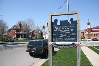
On High Street (Ohio Route 129/177) at Monument Avenue, on the right when traveling east on High Street.
4 Ohio, Champaign County, Urbana — C22 — Hull's Headquarters
On Main Street (U.S. 68) at Fyffe Street, on the left when traveling north on Main Street.
5 Ohio, Champaign County, Urbana — C22X — Simon Kenton — Ohio Revolutionary Memorial Trail
On Scioto Street east of North Main Street (U.S. 68), on the right when traveling west.
6 Ohio, Clark County, Springfield — C — Kenton's Stockade — Ohio Revolutionary Memorial Trail
On Main Street (U.S. 40) west of Broadway Street, on the right when traveling west.
7 Ohio, Clark County, Springfield, Shawnee Springs — Battle of Piqua — August 8, 1780
On Tecumseh Road (Ohio Route 369) north of Lower Valley Pike.
8 Ohio, Darke County, Fort Jefferson — C — Fort Jefferson — Ohio Revolutionary Memorial Trail
On Ohio Route 121 at Weavers-Fort Jefferson Road (County Route 24), on the right when traveling south on State Route 121.
9 Ohio, Darke County, Greenville — C15 — Fort Greene-Ville — Ohio Revolutionary Memorial Trail
On South Broadway Street (Ohio Route 49) at West Main Street, on the right when traveling south on South Broadway Street.
10 Ohio, Defiance County, Defiance — C — Abatis and Camp — Ohio Revolutionary Memorial Trail
On South Clinton Street (Ohio Route 111) south of Sunday Street, on the right when traveling south. Reported missing.
11 Ohio, Defiance County, Defiance — A95 — Fort Defiance — Ohio Revolutionary Memorial Trail — Wayne-Harrison-Winchester-Clay-Bird Marches —
On Fort Street at South Clinton Street (Ohio Route 66), on the right when traveling west on Fort Street.
12 Ohio, Defiance County, Defiance — A96 — Fort Winchester — Ohio Revolutionary Memorial Trail — Wayne-Harrison-Winchester-Clay-Bird Marches —
On Fort Street at Washington Avenue, on the right when traveling west on Fort Street.
13 Ohio, Defiance County, Defiance — C32 — Fort Winchester — Ohio Revolutionary Memorial Trail
On West 2nd Street at Washington Avenue, on the right when traveling east on West 2nd Street.
14 Ohio, Defiance County, Defiance — C322 — Pontiac Birthplace — Ohio Revolutionary Memorial Trail
On East River Drive (Ohio Route 424) 0.2 miles east of North Clinton Street (Ohio Route 66), on the right when traveling east.
15 Ohio, Delaware County, Delaware — C — Pluggy's Town — Ohio Revolutionary Memorial Trail
On North Sandusky Street at East Lincoln Avenue, on the right when traveling north on North Sandusky Street. Reported missing.
Paid Advertisement
16 Ohio, Franklin County, Columbus, Franklinton — C — Headquarters of General William H. Harrison — Ohio Revolutionary Memorial Trail
On West Broad Street (U.S. 40) at North Gift Street, on the right when traveling west on West Broad Street. Reported missing.
17 Ohio, Greene County, Oldtown — Kenton's Gantlet [Gauntlet]
On U.S. 68, on the left when traveling south. Reported missing.
18 Ohio, Greene County, Oldtown — C1 — Site of Old Chillicothe
On U.S. 68, 0.1 miles south of Brush Row Road, on the right when traveling south. Reported permanently removed.
19 Ohio, Hamilton County, Cincinnati, Over-The-Rhine — C62 — Ohio Military Trails — Ohio Revolutionary Memorial Trail
On East Central Parkway (U.S. 42) near Main Street, in the median.
20 Ohio, Hamilton County, North Bend — C — Miami Fort / Fort Finney — Ohio Revolutionary Memorial Trail
On Brower Road, 4.1 miles west of Miami Avenue, on the left when traveling west.
21 Ohio, Hancock County, Williamstown — C — Fort Necessity — Ohio Revolutionary Memorial Trail
On U.S. 68 at County Route 10, on the right when traveling south on U.S. 68. Reported missing.
22 Ohio, Hardin County, Kenton — C35 — Fort McArthur — Ohio Revolutionary Memorial Trail
On North Detroit Street (U.S. 68) near East Franklin Street (Ohio Route 309), on the right when traveling north.
23 Ohio, Hardin County, Kenton — C — Knight's Escape — Ohio Revolutionary Memorial Trail
On Ohio Route 67 at County Route 215, on the right when traveling north on State Route 67. Reported missing.
24 Ohio, Henry County, Florida — C — Girty's Island — Ohio Revolutionary Memorial Trail
On Ohio Route 424 south of County Route M, on the right when traveling south. Reported missing.
25 Ohio, Highland County, Highland — B — Kenton and Tecumseh Directional Marker — Ohio Revolutionary Memorial Trail
On Main Street (Ohio Route 28) near New Lexington Avenue (Ohio Route 72) when traveling east.
26 Ohio, Logan County, Bellefontaine — C364 — Blue Jacket Town — Ohio Revolutionary Memorial Trail
On South Main Street (U.S. 68) at East Columbus Avenue, on the left when traveling south on South Main Street.
27 Ohio, Logan County, West Liberty — C — Mac-O-Chee Towns — Ohio Revolutionary Memorial Trail
On Route 245 at Township Road 47, on the right when traveling east on Route 245. Reported missing.
28 Ohio, Logan County, Zanesfield — C — Kenton's Farm — Ohio Revolutionary Memorial Trail
On County Route 5 at County Route 25, on the left when traveling north on County Route 5. Reported missing.
29 Ohio, Logan County, Zanesfield — C36 — Wapatomica — Ohio Revolutionary Memorial Trail
On County Route 5, 0.1 miles south of County Route 29, on the left when traveling north.
30 Ohio, Logan County, Zanesfield — C362 — Zanesfield — Ohio Revolutionary Memorial Trail
On Sandusky Street, on the right when traveling north.
31 Ohio, Lucas County, Maumee — C27 — Dudley's Massacre — Ohio Revolutionary Memorial Trail
On River Road, 0.1 miles north of East John Street, on the right when traveling south.
Paid Advertisement
32 Ohio, Lucas County, Maumee — C — Fallen Timbers Battlefield — Ohio Revolutionary Memorial Trail
On West River Road at Jerome Road, on the left when traveling north on West River Road. Reported missing.
33 Ohio, Lucas County, Maumee — C — Hull's Crossing/Turkey Foot Rock — Ohio Revolutionary Memorial Trail
Near North River Road, 0 miles south of Jerome Road, on the right when traveling south. Reported missing.
34 Ohio, Lucas County, Maumee — C — Site of Fort Miami — Ohio Revolutionary Memorial Trail
Near River Road at Michigan Avenue. Reported missing.
35 Ohio, Lucas County, Maumee — A84 — to Hull's Crossing / to River Raisin — Ohio Revolutionary Memorial Trail — Hull-Winchester Marches
On River Road at South Detroit Avenue, on the right when traveling north on River Road. Reported missing.
36 Ohio, Lucas County, Toledo — A86 — Michigan - Ohio State Line — Ohio Revolutionary Memorial Trail — Hull-Winchester Marches
On North Detroit Avenue south of Benore Road, on the right when traveling north. Reported missing.
37 Ohio, Lucas County, Waterville — C — Site of Fort Deposit / Roche de Boeuf — Ohio Revolutionary Memorial Trail
On South River Road at Anthony Wayne Trail (Ohio Route 53), on the right when traveling south on South River Road. Reported missing.
38 Ohio, Marion County, Waldo — C55 — Fort Morrow — Ohio Revolutionary Memorial Trail
On Brundage Road (Local Route 125) 0.7 miles north of Ohio Route 229, on the left when traveling north.
39 Ohio, Mercer County, Fort Recovery — C150 — St. Clair's Defeat / Fort Recovery — Ohio Revolutionary Memorial Trail
On North Elm Street (Ohio Route 49) north of Butler Street (Ohio Route 119), on the right when traveling south.
40 Ohio, Mercer County, Mendon — C — Fort Adams — Ohio Revolutionary Memorial Trail
On U.S. 127 north of Ohio Route 707, on the right when traveling north. Reported missing.
41 Ohio, Miami County, Piqua — C — Fort Pickawillany — Ohio Revolutionary Memorial Trail
On North Hardin Road (County Route 110) north of Ohio Route 66, on the right when traveling north. Reported missing.
42 Ohio, Miami County, Piqua — C — Indian Agency House — Ohio Revolutionary Memorial Trail
On North Hardin Road (County Route 110) north of Ohio Route 66, on the right when traveling north.
43 Ohio, Montgomery County, Dayton, McCook Field — C5 — Hull's Rendezvous
On Webster Street at Deeds Park Drive, on the left when traveling north on Webster Street.
44 Ohio, Ottawa County, Port Clinton — C47 — End of Harrison's Trail in Ohio - War of 1812 — Ohio Revolutionary Memorial Trail
On West 3rd Street at Monroe Street, on the right when traveling west on West 3rd Street.
45 Ohio, Paulding County, Charloe — C — Charloe — Ohio Revolutionary Memorial Trail
On County Route 171 at County Route 138, on the right when traveling south on County Route 171. Reported missing.
46 Ohio, Paulding County, Charloe — C — Fort Brown — Ohio Revolutionary Memorial Trail
On County Route 171 at County Route 177, on the right when traveling south on County Route 171. Reported missing.
47 Ohio, Preble County, Eaton — C — Fort St. Clair — Ohio Revolutionary Memorial Trail
On Camden Road (Ohio Route 355) south of Main Street (Ohio Route 122), on the right when traveling south. Reported missing.
Paid Advertisement
48 Ohio, Preble County, Eaton — C10 — Fort St. Clair — Ohio Revolutionary Memorial Trail
On Barron Street (U.S. 127) at Main Street, on the left when traveling south on Barron Street. Reported missing.
49 Ohio, Preble County, Eaton — C — Forty Foot-Pitch — Ohio Revolutionary Memorial Trail
Near U.S. 127 at Kayler Road, on the left when traveling north. Reported missing.
50 Ohio, Preble County, Eaton — C — Ludlow Springs — Ohio Revolutionary Memorial Trail
On U.S. 127 south of Winnerline Road, on the right when traveling south. Reported missing.
51 Ohio, Putnam County, Ottoville — C — Fort Jennings — Ohio Revolutionary Memorial Trail
On 3rd Street (Ohio Route 189) at Wayne Street (Ohio Route 66), on the left when traveling south on 3rd Street. Reported missing.
52 Ohio, Sandusky County, Fremont — C44 — Brady's Island — Ohio Revolutionary Memorial Trail
On North Front Street, on the right when traveling north.
53 Ohio, Sandusky County, Fremont — C 41 — Fort Stephenson — Ohio Revolutionary Memorial Trail
On West State Street (U.S. 20Bus) at North Arch Street, on the right when traveling east on West State Street.
54 Ohio, Sandusky County, Fremont — C42 — Great Gathering Place — Ohio Revolutionary Memorial Trail
On North Park Avenue at Court Street, on the right when traveling north on North Park Avenue.
55 Ohio, Sandusky County, Fremont — C43 — Indian Gantlet and Race Course — Ohio Revolutionary Memorial Trail
On North Front Street north of West State Street, on the right when traveling north.
56 Ohio, Sandusky County, Fremont — C — Pontiac Conspiracy — Ohio Revolutionary Memorial Trail
On North Front Street at Haynes Street, on the left when traveling north on North Front Street. Reported missing.
57 Ohio, Sandusky County, Fremont — C45 — Whittaker's Reserve — Ohio Revolutionary Memorial Trail
On Port Clinton Road, 0.1 miles south of Whittaker Drive, on the right when traveling north.
58 Ohio, Seneca County, Fort Seneca — A1340 — to Brady's Island / to Battle Island — Ohio Revolutionary Memorial Trail — Harrison-Shelby Marches —
On Fremont-Tiffin Road (Ohio Route 53) at Township Road 1020 on Fremont-Tiffin Road.
59 Ohio, Shelby County, Fort Loramie — C — Loramie's Store 1769 & Fort Loramie 1794 — Ohio Revolutionary Memorial Trail
On Ohio Route 66 south of Canal Road (County Route 191). Reported missing.
60 Ohio, Shelby County, Fort Loramie — C — Pioneer Portage — Ohio Revolutionary Memorial Trail
On North Main Street (Ohio Route 66) at Elm Street (Ohio Route 362), on the right when traveling south on North Main Street.
61 Ohio, Van Wert County, Van Wert — C — Wayne's Strategy — Ohio Revolutionary Memorial Trail
On Washington Street (U.S. 127) at Main Street, on the left when traveling south on Washington Street. Reported missing.
62 Ohio, Wood County, Bowling Green — C — General Hull's Trail — Ohio Revolutionary Memorial Trail
On North Dixie Highway (Ohio Route 25) at Middleton Pike (Ohio Route 582), on the right when traveling north on North Dixie Highway.
63 Ohio, Wood County, Luckey — A126 — to Whittaker's Reserve / to Dudley's Massacre — Ohio Revolutionary Memorial Trail — Harrison's March
On Fremont Pike (U.S. 20) at Bradner Road (County Route 16), on the right when traveling east on Fremont Pike. Reported missing.
Paid Advertisement
64 Ohio, Wood County, Otsego, Washington Township — C608 — Maumee Indian Mission — Ohio Revolutionary Memorial Trail
On West River Road (Ohio Route 65) 0.2 miles north of Middleton Pike, on the left when traveling north.
65 Ohio, Wood County, Perrysburg — C — Clay's Landing — Ohio Revolutionary Memorial Trail
On West River Road (Ohio Route 65) at Holly Lane, on the right when traveling west on West River Road. Reported missing.
66 Ohio, Wood County, Perrysburg — B — Fort Meigs Directional Marker — Ohio Revolutionary Memorial Trail
On West Front Street (U.S. 20) at Louisiana Avenue (Ohio Route 199), on the right when traveling west on West Front Street.
67 Ohio, Wood County, Perrysburg — A125 — to Brady's Island / to Fort Miami — Ohio Revolutionary Memorial Trail — Harrison's March
On Fremont Pike (U.S. 20) east of Thompson Road, on the right when traveling east. Reported missing.
68 Ohio, Wood County, Perrysburg — A122 — to Dudley's Massacre / to Portage Stockade — Ohio Revolutionary Memorial Trail — Harrison-Hull-Tupper Marches
On Dixie Highway (Ohio Route 25) at Ovitt Road (County Route 104), on the left when traveling north on Dixie Highway. Reported missing.
69 Ohio, Wood County, Perrysburg — A123 — to Fort Meigs / to Fort Meigs — Ohio Revolutionary Memorial Trail — Harrison-Hull-Tupper Marches
On West Boundary Street (Ohio Route 25) near West Front Street (Ohio Route 65), on the left when traveling north. Reported missing.
70 Ohio, Wood County, Perrysburg — A124 — to Fort Stephenson / to Fort Meigs — Ohio's Revolutionary Memorial Trail — Harrison's March 1813
On West Front Street (Ohio Route 65) at West Boundary Street (Ohio Route 25), on the right when traveling west on West Front Street. Reported missing.
71 Ohio, Wood County, Portage — C — Portage Stockade — Ohio Revolutionary Memorial Trail
On Dixie Highway South (Ohio Route 25) south of Main Street, on the right when traveling south. Reported missing.
72 Ohio, Wyandot County, Crawford — C52 — Burning of Crawford — Ohio Revolutionary Memorial Trail
On Ohio Route 199 at County Route 29, on the left when traveling north on State Route 199.
73 Ohio, Wyandot County, Lovell — A140 — to Crawford's Burning / to Battle Island — Ohio Revolutionary Memorial Trailh — Harrison's March
On Ohio Route 199 at County Route 42, on the left when traveling north on State Route 199. Reported missing.
74 Ohio, Wyandot County, Upper Sandusky — C — Battle Island — Ohio Revolutionary Memorial Trail
On Ohio Route 53 at Ohio Route 67, on the right when traveling north on State Route 53. Reported missing.
75 Ohio, Wyandot County, Upper Sandusky — C481 — Fort Ferree — Ohio Revolutionary Memorial Trail
On S. Sandusky Avenue (Ohio Route 53) at E. Wyandot Avenue (U.S. 30), on the right when traveling north on S. Sandusky Avenue. Reported permanently removed.
76 Ohio, Wyandot County, Upper Sandusky — A147 — to Fort Morrow / to Fort Ferree — Ohio's Revolutionary Memorial Trail — Harrison's March 1813 —
On County Route 113 south of County Route 126, on the right when traveling south.
 
 
CeraNet Cloud Computing sponsors the Historical Marker Database.
This website earns income from purchases you make after using our links to Amazon.com. We appreciate your support.
Paid Advertisement
May. 6, 2024