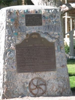
In 1883 the Carson & Colorado Railroad was built between Mound House (Near Carson City, Nevada) through Laws to Keeler, California, a distance of 300 miles. Laws Station was named in honor of Mr. R.J. Laws, Assistant Superintendent of the . . . — — Map (db m10333) HM
On Highway 6 (U.S. 6) at Silver Canyon Road, on the right when traveling east on Highway 6.
The first white man’s settlement in northern Owens Valley was built here in 1861 and two years later prospectors named it Owensville. It thrived for some time but in 1864, as mining in the White Mts. petered out the miners moved on to better . . . — — Map (db m2953) HM
On West Line Road (California Route 168) west of Muny Road, on the right when traveling west.
In 1861, Samuel A. Bishop, his wife and party left Fort Tejon for the Owens Valley driving 650 head of stock. On August 22, Bishop reached a creek later named for him and southwest of this spot, established San Francis Ranch. There a peace treaty . . . — — Map (db m627) HM
On U.S. 395, 1 mile east of U.S. 395, on the left when traveling east. Reported missing.
In June 1873 Colonel Sherman Stevens built a sawmill and flume on Cottonwood Creek high in the Sierras directly west of this spot. The flume connected with the Los Angeles Bullion Road. The lumber from the flume was used for timbering in the mine . . . — — Map (db m33877) HM
On U.S. 395 at and an un-named dirt road, on the left when traveling south on U.S. 395.
In June 1873 Colonel Sherman Stevens built a sawmill and flume on Cottonwood Creek high in the Sierra’s directly west of this spot. The flume connected with the Los Angeles Bullion Road. The lumber from the flume was used for timbering in the . . . — — Map (db m52104) HM
On West Side Road, 16 miles south of Badwater Road, on the left when traveling south.
Near this spot the Bennett-Arcane contingent of the Death Valley '49ers, emigrants from the Middle West, seeking shortcut to California gold fields, were stranded for a month and almost perished from starvation. William Lewis Manley and John Rogers, . . . — — Map (db m159315) HM
On California Route 190 at Badwater Road, on the right when traveling west on State Route 190.
Through this natural gateway the Death Valley Forty-Niners, more than one hundred emigrants from the middle west, seeking a shortcut to gold fields of central California, entered Death Valley in
December, 1849. All suffered from thirst and . . . — — Map (db m167508) HM
On California Route 190 at Cottonwood Canyon Road, on the right when traveling east on State Route 190.
In 1926 H.W. Eichbaum obtained a franchise for a toll road from Darwin Falls to Stovepipe Wells, the first maintained road into the valley from the west. It changed the area from mining to tourism and brought about the creation of Death Valley . . . — — Map (db m149164) HM
On California Route 190 at Borax Mill Road, on the left when traveling north on State Route 190.
On the marsh near this point borax was discovered in 1881 by Aaron Winters who later sold his holdings to W. T. Coleman of San Francisco. In 1882 Coleman built the Harmony Borax Works and commissioned his superintendent J. W. S. Perry to design . . . — — Map (db m158971) HM
On Stovepipe Wells Road, 0.8 miles west of Scotty's Castle Road, on the right when traveling west.
This waterhole, only one in the sand dune area of Death Valley, was at the junction of two Indian trails. During the bonanza days of Rhyolite and Skidoo it was the only known water source on the cross-valley road. When sand obscured the spot, a . . . — — Map (db m94591) HM
Near this monument, Jayhawker group of Death Valley Forty-Niners, gold seekers from middle west, who entered Death Valley in 1849 seeking short route to mines of Central California, burned their wagons, dried the meat of some oxen and, with . . . — — Map (db m89481) HM
On Shabbell Lane, 0.3 miles north of U.S. 395, on the right when traveling north.
At the request of settlers, Colonel George Evans led a military expedition to this site on July 4, 1862. Hence its name “Independence”. Indian hostilities ceased and the camp closed. War again broke out in 1865 and the camp was reoccupied as Fort . . . — — Map (db m2954) HM
On Highway 395, on the right when traveling south.
In the early part of the World War II, 110,000 persons of Japanese ancestry were interned in relocation centers by Executive Order No. 9066, issued on February 19, 1942.
Manzanar, the first of ten such concentration camps, was bounded by . . . — — Map (db m122703) HM WM
On Market Street at Webster Street, on the right when traveling west on Market Street.
“But if ever you come beyond the borders as far as the town that lies in a hill dimple at the foot of Kearsarge, never leave it until you have knocked on the door of the brown house under the willow-tree at the end of the village street, and there . . . — — Map (db m2955) HM
On Highway 395 south of Bush Street, on the right when traveling south.
One hundred thirty feet west of this site, Charles Putnam built the first cabin of permanent habitation in what is now Inyo County in August 1861. The building served as a home, trading post, hospital, and “fort” for early settlers, as well as a . . . — — Map (db m2957) HM
Near California Route 136, 9.6 miles east of U.S. 395, on the right when traveling east.
The Owens Lake Silver-Lead Furnace and Mill was built here by Col. Sherman Stevens in 1869 and used until March 1874. James Brady assumed its operation in 1870 for the Silver-Lead Company and built the town of Swansea. During the next few years the . . . — — Map (db m72576) HM
Near U.S. 395, 0.1 miles south of Pangborne Lane, on the right when traveling south.
On the date of March 26, 1872, an earthquake of major proportions shook Owens Valley and nearly destroyed the town of Lone Pine.
Twenty seven persons were killed.
In addition to single burials, 16 of the victims were interred in a . . . — — Map (db m34157) HM
On U.S. 395 at Fall Road, on the left when traveling north on U.S. 395.
M.H. Farley, working for the Silver Mountain Mining Company in the Coso Mountains, conceived the idea in 1860 of building a processing mill on a creek flowing into Owens Lake. He explored and named Olancha Pass that year, and completed the first . . . — — Map (db m239638) HM
On Trona Wildrose Road just north of Valley Wells Road, on the right when traveling north.
In this area, several groups of midwestern emigrants, who had escaped from hazards and privations in Death Valley in 1849, sought to secure water from Searles Lake. When they discovered its salty nature, they turned northward and westward in . . . — — Map (db m93441) HM
Padre Garcés, first recorded non-Indian to visit this locality, came in April of 1776, seeking a new route from Mexico to California. His epic journey covered more than two thousand miles of uncharted wilderness, opening trails that later became . . . — — Map (db m11932) HM
On Truxtun Avenue at Chester Avenue, on the right when traveling east on Truxtun Avenue.
Colonel Thomas Baker, Civil Engineer – Lawyer — Farmer – Soldier, 1810 – 1872.
In 1863 Colonel Baker came to this location. A friend to all travelers, his settlement became known at “Baker’s Field.” This civic center is his dream come true. . . . — — Map (db m134436) HM
On Round Mountain Road, 0.8 miles east of China Grade Loop, on the right when traveling east.
Oil was discovered at 70 feet in 1899, when Tom Means persuaded Roe Elwood and Frank Wiseman, aided by Jonathan, Bert, Jed, and Ken Elwood, George Wiseman, and John Marlowe, to dig here for oil. On June 1, 1899, 400 feet to the north, Horace and . . . — — Map (db m168102) HM
On North Chester Avenue at Golden State Highway (California Route 204), in the median on North Chester Avenue.
Padre Garces seeking a new route between Sonora, Mexico and Monterey crossed Rio de San Felipe (Kern River May 7, 1776) at Rancheria San Miguel now Bakersfield. First recorded white man in this locality, he brought Christianity to the Indian and on . . . — — Map (db m34769) HM
On China Grade Loop, on the right when traveling south.
Gordon’s Ferry was an overhead cable type of ferry operated during the 1850’s by Major Gordon. An adobe station house was located on the south bank of Kern River, just a few yards to the west of this marker. It was also a station on the Butterfield . . . — — Map (db m25149) HM
On West Columbus Street at Isla Verde Street, on the right when traveling west on West Columbus Street.
Near this spot stood the last home of Elisha Stevens, noted American pathfinder and scout. Born in Georgia April 5, 1804, he learned blacksmithing during his youth. Drifting west he became a trapper on the Upper Missouri for more than two decades. . . . — — Map (db m231869) HM
On Panama Road, 0.7 miles east of Cottonwood Road, on the right when traveling east.
Just south of this point stood the Butterfield Overland Stage site known as Kern River Slough. Operating through present Kern County during 1858 – 1861. This famous line ran from St. Louis, Missouri to San Francisco until the outbreak of the . . . — — Map (db m24946) HM
Near R Street north of 19th Street. Reported missing.
Near this site stood the home of Alexis Godey, frontiersman and scout, who lived here from 1883 until his death on January 19, 1889. Born in St. Louis, Missouri in 1818, he acted as guide for John C. Frémont's expedition through the Kern area in . . . — — Map (db m51676) HM
On Bakersfield-Glennville/Granite Road at Round Mountain Road, on the left when traveling south on Bakersfield-Glennville/Granite Road.
Two and one half miles east of this point, on a small flat south of Poso Creek, is the site of one of six stagecoach stations in Kern County belonging to the Butterfield Overland Mail Company. The Butterfield Company operated along a southern route . . . — — Map (db m168620) HM
On Kern Canyon Road (State Highway 178), on the left when traveling east.
One mile north of here on May 1, 1776, Francisco Garces of the Franciscan Order, crossed Kern River in his search for a shorter route from Sonora, Mexico to Monterey, California. He was the first known explorer to describe this river, which he . . . — — Map (db m24984) HM
On Buttonwillow Drive, 0.5 miles north of California Highway 58, on the left when traveling north.
A lone tree landmark on an old trans-valley trail. It was an ancient Yokuts Indian meeting place, later a location for white stock rodeos. Miller and Lux established their headquarters and store here about 1885. The town of Buttonwillow takes its . . . — — Map (db m50251) HM
Named for Edward F. Beale, this station on the Southern Pacific rail line was established in 1876 as a depot and telegraph office. Service was discontinued in 1943. Beale was Superintendent of California Indian Affairs during the 1850’s. In 1865 he . . . — — Map (db m119218) HM
On Bealville Road, on the right when traveling east.
Originally known as Allen's Camp after Gabriel Allen, who in the 1870s had a cabin and stock pasture near here, the settlement was named Caliente when railroad construction reached this point in April 1875. The town became a railroad terminal for . . . — — Map (db m157683) HM
This spring was on the old Indian Horsethief Trail and later (1834) Joe Walker Trail. The famished Manly-Jayhawk Death Valley parties (1849-50) were revived here after coming from Indian Wells through Last Chance Canyon. This was also a station on . . . — — Map (db m117039) HM
On Mocal Road, 1.2 miles west of Highway 33, on the right when traveling west.
Near an area of small 40 and 50 barrel wells, it blew in over the derrick top November 27th, 1909, with a production of 2,000 barrels a day, and started one of the greatest oil booms California ever experienced.
“For a long time it . . . — — Map (db m130234) HM
On Evans Road (State Highway 155), on the left when traveling west.
Kern County’s oldest residence. Built before Civil War by Thomas Fitzgerald as trading post at junction of two Indian trails. Present Greenhorn Road follows east – west trail (later McFarlane Toll Road) to Kern River mining districts. Town named . . . — — Map (db m25032) HM
On Jacks Valley Road at White River Road, on the right when traveling west on Jacks Valley Road.
In 1854 John C. Reid filed a squatter’s claim on this spot. This same year Kern County’s first school class was held here. In 1859 David Lavers, with his father and brother, John, built a hotel and stage barn on the Old Bull Road. The crossing was . . . — — Map (db m25323) HM
Wm. B. Rose, in 1875, a mile east; built an adobe stage station on the site of the Overland Mail Way Station established 1858. From 1853 to 1875 site was known as Rancho Canoa (trough). Originally vaquero camp of the Sebastian Indian Reservation. . . . — — Map (db m20196) HM
On Grapevine Road West near Interstate 5, on the right when traveling north.
The Sebastian or Tejon Indian Reservation (headquarters 10 miles east of here) was established in 1853 by Gen. Edward Fitzgerald Beale as one of several California Reservations. The number of Indians quartered here varied from 500 to 2000. General . . . — — Map (db m108915) HM
On Caliente-Bodfish Road (County Route 483), on the right when traveling north.
Gold deposits at Havilah were discovered in 1864. Havilah was the county seat between 1866, when Kern County was organized, and 1872, when the government was moved to Bakersfield. Havilah was an active mining center for more than 20 years, and . . . — — Map (db m51821) HM
On Isabella Walker Pass Road (State Highway 178 at milepost 88), on the right when traveling west. Reported missing.
In 1834 explorer Joseph R. Walker passed this junction of Indian trails after discovering nearby Walker Pass. Death Valley 49er parties here diverged west and south after their escape from Death Valley enroute to the California gold fields. Later . . . — — Map (db m207791) HM
On Aerospace Highway (State Highway 14 at milepost 62.6), on the right when traveling south.
Indian water hole on Joseph R. Walker trail of 1834 where Manly-Jayhawker parties of 1849 found their first water after five days of travel from Argus Range. During 1860's was site of stage and freight station from Los Angeles to Coso and Cerro . . . — — Map (db m50243) HM
Near Woodford-Tehachapi Road, 0.5 miles east of Keene, on the left when traveling east.
Cesar Chavez, the farmworker who became this
nation's most important Latino leader in the
20th century, chose this as his home, office, and
final resting place. Here he found spiritual and
physical refuge from the conflict and threats
faced by . . . — — Map (db m140336) HM
Near Wofford Heights Boulevard near Burlando Road (County Road 495), on the right.
Kernville called Whiskey Flat until 1864, was founded in 1860 when Adam Hamilton, whiskey dealer, moved shop here from more temperate Quartzburg, founded earlier that year. Both camps resulted from the discovery of the Big Blue Ledge by “Lovely” . . . — — Map (db m25169) HM
On California Route 178, on the left when traveling east.
Near this spot at the confluence of the north and south forks of the Kern River the Theodore Talbot Party of Captain John C. Fremont’s third expedition to the West camped for several weeks during December 1845 and January 1846. The river was named . . . — — Map (db m25092) HM
On Keyesville Road, 2 miles west of Highway 155, on the right when traveling west.
From 1853 until 1870 Keyesville was a center of both placer and quartz gold mining. On the knoll just below the townsite may still be seen the outlines of an earth-work fort, built to meet a possible Indian attack in 1863. The original Keys Mine is . . . — — Map (db m143331) HM
On Lebec Road just west of Interstate 5, on the right when traveling south.
In 1772, Don Pedro Fages, leaving the first written record of explorations in the south San Joaquin Valley, passed this site, traveling from San Diego to San Luis Obispo via Cajón Pass, Mojave Desert, Hughes Lake, Antelope Valley, Tejón Pass, . . . — — Map (db m20132) HM
This military post was established by the United States Army on June 24, 1854, to suppress stock rustling and for the protection of Indians in the San Joaquin Valley. As regimental headquarters of the First Dragoons, Fort Tejón was an important . . . — — Map (db m117523) HM
On Petroleum Club Road, on the left when traveling north.
America's most spectacular gusher blew in here on March 14, 1910. Initially 18,000 barrels per day, the flow later reached an uncontrolled peak of 100,000 barrels per day, completely destroying the derrick. This Union Oil Company well produced nine . . . — — Map (db m54267) HM
On Lokern Road at Westside Highway (County Route 33), on the right when traveling west on Lokern Road.
Eight miles due west of this marker stood one of California's first commercial oil refineries. Between August 1864 and April 1867, approximately 4,000 gallons of illuminating oil produced there was shipped to San Francisco by the Buena Vista . . . — — Map (db m78295) HM
On State Highway 58 at State Highway 33, on the left when traveling west on State Highway 58.
Located one-eighth mile west of here is an
ancient asphaltum seepage in which hundreds
of Pleistocene Age (15,000-50,000 years ago)
birds, insects, and animals were trapped.
The skeletal remains found in the pit include
giant condors, giant . . . — — Map (db m168958) HM
On Maricopa Highway (Highway 166), on the right when traveling west.
In 1772, Don Pedro Fages, first recorded non-Indian to visit the southern San Joaquin Valley, crossed this spot on his way from San Diego to San Luis Obispo. Near this point crossed Father José María de Zalvidea in 1806, while accompanying the Ruiz . . . — — Map (db m54266) HM
On David Road at North Wheeler Ridge Road, on the right when traveling east on David Road.
Six miles east of this point was the site of the Butterfield Stage Line station Sinks of Tejón. Operating through present Kern County during 1858-61, this famous line ran from St. Louis, Missouri to San Francisco until the outbreak of the Civil War. — — Map (db m144943) HM
On California Route 14 north of Nadeau Street, on the right when traveling north.
Just west of this point was the Southern Pacific terminus for the Twenty-Mule-Team Borax wagons that operated between Death Valley and Mojave from 1884 to 1889. The route ran from the Harmony Borax Mining Company works, later acquired by the . . . — — Map (db m123891) HM
On Isabella Walker Pass Road (State Highway 178 at milepost 79.8), on the right when traveling east.
Discovered by Joseph R. Walker, American trail-blazer who left the San Joaquin Valley through this pass in 1834. This area was traversed by topographer Edward M. Kern, after whom the Kern River was named, while accompanying the Fremont expedition of . . . — — Map (db m159834) HM
In 1896 Eugene Garlock constructed a stamp mill near this spot for the crushing of gold ore from the Yellow Aster Mine on Rand Mountain. Known originally as Cow Wells, by prospectors and freighters during the 1880’s and early 1890’s, the town of . . . — — Map (db m51672) HM
On Butte Avenue at Highland Avenue on Butte Avenue.
The Yellow Aster, or Rand Mine, was discovered in April, 1895 by Singleton Burcham and Mooers. The town of Randsburg quickly developed followed by the supply town of Johannesburg in 1896. Both names were adopted from the profusion of minerals . . . — — Map (db m50461) HM
On Manly Road, 0.4 miles north of Truman Road, on the right when traveling north.
Visited by Padre Garces (1776) while following Old Horse Thief Trace later known as Joe Walker Trail. Fremont stopped here (1844). The famished Jayhawk Party (1850) found water here while struggling from Death Valley to Los Angeles. Still later was . . . — — Map (db m156684) HM
On Manly Road, 0.2 miles north of Truman Road, on the left when traveling north.
Willow Springs was a stage station on the Los Angeles-Havilah Stage Lines, 1864-1874. From here light traffic went through Oak Creek Pass via Tehachapi to Havilah and Kernville; heavy traffic went northwest to the Inyo mines, or via Jawbone Canyon . . . — — Map (db m156685) HM
On Shafter Avenue north of Merced Avenue, on the right when traveling south.
The Shafter Cotton Research Station, established here in 1922 by the U.S. Department of Agriculture, developed the "Acala" varieties which were exceptionally well suited to the San Joaquin Valley. The quality of the acala cottons and the marketing . . . — — Map (db m52055) HM
On Vultee Street at East Lerdo Highway on Vultee Street.
This plaque at Shafter Airport commemorates the world's first man-powered flight to complete the Kremer Circuit, August 23, 1977. The circuit, a figure eight around two pylons one-half mile apart, was completed in six minutes, twenty-two seconds. . . . — — Map (db m131044) HM
Near Lake Station Road, 2.7 miles north of Gardner Field Road.
The old Yokuts village of Tulamniu was named Buena Vista by Spanish Commander Fages in 1772. (One of first place names in south San Joaquin Valley.) Fr. Zalvidea again recorded the site in 1806. This village was occupied for several centuries. . . . — — Map (db m130232) HM
On Old Town Road at Woodford Tehachapi Road, on the right when traveling north on Old Town Road.
The oldest settlement in Tehachapi Valley, known as 'Old Town,' was established here during the 1860s. It was long an important station on the road between Southern California and the San Joaquin Valley. The community began to decline when residents . . . — — Map (db m139964) HM
On Tehachapi-Willow Springs Road, on the right when traveling north.
Father Francisco Garces used the Oak Creek Pass in 1776 to return to the Mojave after exploring the San Joaquin Valley, as did Fremont in 1844-45. Until the building of the railroad through the Tehachapi Pass in 1876, Oak Creek Pass was the only . . . — — Map (db m50250) HM
On Woodford-Tehachapi Road, 3.2 mi E of Keene exit, on the left when traveling east.
From this spot may be seen a portion of the world-renowned “Loop.” It was completed in 1876 under the direction of William Hood, Southern Pacific Railroad Engineer. In gaining elevation around central hill of loop a 4000 foot train will cross 77 . . . — — Map (db m134430) HM
Near Basalt Road, 1 mile south of Tranquility Road.
In the Kawaiisu language, tomo-kahni means winter village. The site's location between the coast and desert allowed the site occupants to hold an important place for trade between these areas and the southern Central Valley. The sacred rock art . . . — — Map (db m92889) HM
On Garces Highway (State Highway 155), on the right when traveling west.
On May 3, 1776, three miles north of this point at a Yokut village site in Grizzly Gulch, father Francisco Garcés performed the first recorded baptism in the San Joaquin Valley. The service was held for a dying Yokut boy he called Muchachito (young . . . — — Map (db m168621) HM
On Bakersfield-Glennville Road, 6.5 miles south of California Route 155, on the right when traveling south.
One and one-half miles north of this point stood the Mountain House Station on the route of the Butterfield Stage. Operating through present Kern County during 1858-1861, this famous line ran from St. Louis, Missouri to San Francisco until the . . . — — Map (db m168616) HM
On 14th Avenue, 0.2 miles north of Elder Avenue, on the right when traveling north.
Here on May 11, 1880, during a dispute over land titles between settlers and railroad, a fight broke out during which seven men lost lives -- two deputy U.S. Marshals and five ranchers. Legal struggle over titles finally compromised. — — Map (db m154063) HM
On Douglas Avenue, 0.3 miles west of 12¾ Avenue, on the right when traveling west.
Founded in 1856 by L.A. Whitmore who operated first Kings River ferry crossing. After 1858 town became stopping place for Butterfield stages. Toll bridge superseded ferry in 1873. On December 26, 1873, Tiburcio Vasquez and bandit gang made bold raid . . . — — Map (db m158224) HM
On 19½ Avenue (State Highway 41) at Lacy Boulevard when traveling south on 19½ Avenue.
This restored adobe, second oldest in San Joaquin Valley, built by Daniel Rhoades, who came to California in 1846 by overland caravan. Rhoades and his brother, John, among organizers of the first expedition to rescue the Donner party at Donner Lake. . . . — — Map (db m66412) HM
On Sulphur Bank Drive at California Route 20, on the left when traveling south on Sulphur Bank Drive.
This sulphur mine also produced quicksilver and
became one of most noted producers in world.
First worked for sulphur in 1865 and in four
years produced total of 2,000,000 pounds.
Reopened and developed for quicksilver in 1873
and credited with . . . — — Map (db m240310) HM
On State Highway 29, 6 miles north of Middletown, on the right when traveling north.
Oldest building in Lake County. Erected of stone in 1853-4 by Robert Sterling, whose wife was first white woman in Coyote Valley. Rebuilt in 1894. Headquarters of the Guenoc Land Grant and the first store in the valley. — — Map (db m16127) HM
On Bell Hill Road (County Road 510) at Main Street, on the right when traveling north on Bell Hill Road.
Built by Charles Stone and Andy Kelsey on land purchased from Salvador Vallejo. Constructed by forced Indian labor, causing much resentment and culminating in murder by Indians of both Stone and Kelsey in the fall of 1849. Their remains are beneath . . . — — Map (db m121713) HM
Near North Main Street north of 2nd Street, on the left when traveling north.
Lake County’s century-old classic courthouse, designed by A.P. Pettit in 1871, served as the seat of county government from 1871 until 1968 when it was replaced by the new courthouse. Among the court’s landmark cases were the White Cap murders, a . . . — — Map (db m152479) HM
On Main Street, 0.1 miles east of California Route 29, on the left when traveling east.
Built in 1876 at the height of the quicksilver mining boom, the Lower Lake stone jail was a response to rapid town growth and the urgent need for civil order. Stephen Nicolai, one of the first stone masons in Lower Lake, built the jail from local . . . — — Map (db m8509) HM
On State Highway 26 at Hill Street, on the left when traveling north on State Highway 26.
The Old Bull Trail Road ran from Napa Valley to Middletown. It was built by volunteers in the 1850’s. A number of grades were 35 percent. It was an official road in 1861 and abandoned in 1868. St. Helena Toll Road also ran from same points. Was . . . — — Map (db m171749) HM
On Highway 20 at Reclamation Road, on the right when traveling south on Highway 20.
One-fourth mile west is the island called Bo-no-po-ti (Old Island), now Bloody Island. It was a place for native gatherings until May 15, 1850. On that date, a regiment of the 1st Dragoons of the U.S. Cavalry, commanded by Capt. Nathaniel Lyon and . . . — — Map (db m171748) HM
Peter Lassen opened the Lassen Emigrant Trail in 1848 when he led a 12-wagon emigrant train from Missouri to California. The route, which passed near this place, was extensively traveled during the years 1848-53 by emigrants seeking gold, adventure, . . . — — Map (db m10264) HM
On State Highway 395, on the left when traveling south.
This route was first used in 1852 by emigrants to Northern California seeking to avoid the hardships of the Lassen Trail. It crossed the desert from the Humbolt River in Nevada, passed this point, and proceeded over the mountains to the town of . . . — — Map (db m10269) HM
Near North Street, on the right when traveling north.
This meadow, now a city park, was a welcome stopping place on the Noble Emigrant Trail, pioneered by William H. Nobles in 1851 and first used in 1852. Here, emigrants en route to the Northern California mines were able to rest, refresh their stocks, . . . — — Map (db m10268) HM
Near North Weatherlow Street, on the right when traveling north.
Built in July 1854 by Isaac N. Roop. First called Roop's House, and used as stopping place by emigrant trains. It was the locale of the "sagebrush war" fought in 1863 between Plumas County and Lassen County citizens. — — Map (db m10266) HM
Through this draw passed many covered wagons and gold seekers enroute to California over the Lassen Trail during 1848-1851. Approaching this location from the north, the trail passed what is now Bogard Ranger Station. Proceeding southward to Big . . . — — Map (db m22027) HM
On Santa Rosa Avenue at Alameda Street, on the right when traveling north on Santa Rosa Avenue.
The 135 Deodar Cedar trees were planted in 1885 by the Woodbury Family, the founders of Altadena. First organized by F.C. Nash in 1920, the "Mile of Christmas Trees" has been strung with 10,000 lights each holiday season through the efforts of . . . — — Map (db m143798) HM
Near Angeles Crest Highway (California Route 2) 26 miles north of Interstate 210.
Built in 1900 alongside the West Fork of the San Gabriel River and north of Mt. Wilson, the historic cabin was the first ranger station built in California with federal government funds — $75. In the late 1920's, new roads into the mountains . . . — — Map (db m154560) HM
Near Baldwin Avenue, 0.3 miles south of Interstate 210, on the right when traveling south.
Constructed by Elias Jackson ('Lucky') Baldwin in 1881. Designed by A.A. Bennett, and intended for entertaining. There being no kitchen, meals were served from the nearby adobe (built by Hugo Reid in 1839) where Baldwin actually lived. Restored and . . . — — Map (db m153410) HM
Near Baldwin Avenue, 0.3 miles south of Interstate 210, on the right when traveling south.
The home place of Elias Jackson “Lucky” Baldwin, founder and first Mayor of the City of Arcadia, was this relatively simple adobe house, though during Baldwin's occupation (1875-1909) it was the larger and more inviting structure seen . . . — — Map (db m153423) HM
Near Huntington Drive west of Baldwin Avenue, on the left when traveling west.
Early in 1942 the US government designated Santa Anita Park for special usage during the war years.
Pursuant to Executive Order 9066 signed by President Franklin D. Roosevelt, from March 30, 1942 until October 27, 1942 the facility was used as . . . — — Map (db m165491) HM
On Saint Catherine Way north of Crescent Avenue, on the right when traveling north.
The Tuna Club of Avalon marks the birthplace of modern big game sportfishing. In 1898, led by Dr. Charles Frederick Holder, the club's founding members adopted the rules of conduct stressing conservationist ethics and sporting behavior. Today, their . . . — — Map (db m49678) HM
Contained within this building are the remaining portions of an adobe house built by Francisco Salvador Lugo and his son Antonio María Lugo. Francisco Lugo was a prominent early landholder and Antonio served as the Alcalde of Los Angeles. They . . . — — Map (db m125567) HM
On La Cienega Boulevard south of Gregory Way, on the right when traveling south.
The expedition of Don Gaspar de Portolá from Mexico passed this way en route to Monterey to begin the Spanish colonization of California. With Captain Don Fernando Rivera y Moncada, Lieutenant Don Pedro Fages, Sergeant José Francisco Ortega, and . . . — — Map (db m125155) HM
Near East Don Julian Road, on the right when traveling north.
Home of pioneer William Workman. Workman and co-owner John Rowland developed the 48,790-acre La Puenta Rancho. Workman and co-leader Rowland organized the first wagon train of permanent eastern settlers which arrived in Southern California on . . . — — Map (db m50981) HM
"El Campo Santo," this region's earliest known private family cemetery, was established in 1850 by William Workman. The miniature Classic Grecian mausoleum was built in 1919 by grandson Walter P. Temple. Included in this cemetery are the remains of . . . — — Map (db m50983) HM
On South Alameda Street, on the right when traveling north.
[The arch way leading to the grounds is flanked by two markers:]
Right Marker:
Domínguez Ranch House
Central portion built in 1826 by Manuel Domínguez.
Rancho San Pedro
Ten square leagues granted, . . . — — Map (db m64857) HM
On Wilmington Avenue north of Curtiss Street, on the right when traveling north.
About one half mile southeast of this spot, on Dominguez Hill in historic Rancho San Pedro, the first Air Meet in the United States was held during January 10-20, 1910. Subsequently, this area has evolved into one of the world's leading . . . — — Map (db m50979) HM
Near Willowbrook Avenue north of Myrrh Street, on the right when traveling south.
The original house of two rooms was built in 1869 by A.R. Loomis. Other rooms were added by successive occupants. It was marked as the "Oldest House in Compton" in 1955; purchased by the city June 11, 1957; and removed from 209 South Acacia Street . . . — — Map (db m50977) HM
Near Santa Anita Avenue south of Valley Boulevard, on the right when traveling south.
El Monte, on the bank of the San Gabriel River, played a significant part in California's early pioneer history. It was first an encampment on the Old Spanish Trail, an extension of the trail from Missouri to Santa Fe. By the 1850's some began . . . — — Map (db m162663) HM
Near Bonita Drive south of Opechee Way, on the right when traveling south.
San Rafael Rancho, first granted to José Maria Verdugo, Oct. 20, 1784.
Catalina Adobe built about 1828.
And, General Andres Pico oak tree camp site, before he surrendered to General John C. Fremont, 1847. — — Map (db m128201) HM WM
1049 entries matched your criteria. Entries 201 through 300 are listed above. ⊲ Previous 100 — Next 100 ⊳