717 entries match your criteria. The first 100 are listed. Next 100 ⊳
Alabama Historical Association Historical Markers
The Alabama Historical Association began sponsoring historical markers as early as 1950 and a standing AHA marker committee was created in 1952. There are now more than 500 markers recognizing the state’s long and diverse past. The distinctive design has a deep blue background with text portrayed in gold letters. The insignia at the top is the Alabama flag. The Alabama Historical Commission also has a similar marker program (and separate HMDb series) which has a circular medallion at the top of the marker with an outline of the state inside.
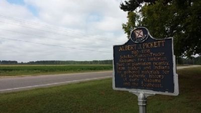
Alabama's first historian lived on plantation nearby. From traders and Indians he gathered materials for his authentic history of early Alabama and the Southeast. — — Map (db m68838) HM
Robert Ripley's world-wide syndicated Believe It Or Not! column for July 31, 1935 read: "C. D. Abbott is the first citizen of the U.S.A. He is first alphabetically in Autaugaville, the first town in Autauga, the first county in Alabama, the . . . — — Map (db m68839) HM
Created in 1818 by an act of Alabama Territorial Legislature. Autauga Indians lived on creek from which the county takes its name. Autaugas were members of the Alibamo tribe. They sent many warriors to resist Andrew Jackson's invasion in Creek War. . . . — — Map (db m27907) HM
This antebellum plantation house was completed by Capt. William Montgomery, a contemporary of Prattville's founder, Daniel Pratt.
This “Deep South” architecture reflects the Federal style with the later addition of a Colonial . . . — — Map (db m70795) HM
(Front): Daniel Pratt CemeteryFinal resting place of early Alabama industrialist Daniel Pratt, 1799-1873, and wife Esther Ticknor Pratt, 1803-1875. He was from New Hampshire and she, Connecticut. Married 1827 at Fortville, Jones County, . . . — — Map (db m168941) HM
Prattville is often referred to as “The Fountain City” for the numerous free-flowing artesian wells found here. A 1933 edition of the Prattville Progress noted that there were more than 400 of these artesian wells in Prattville . . . — — Map (db m70805) HM
Known as Fair Road, Sixth Street from Northington Street to the big curve was called “Happy Hollow”. The road went to the Fair home place but also curved right, into Warren Circle. Here stood a small frame church where the congregation’s . . . — — Map (db m70800) HM
Indian Springs Post Office
Location of considerable Community activity in the early nineteenth-century Autauga County
Thomas Hill House
Site of first Court after Autauga became a County
Union Baptist Meeting House
1830s . . . — — Map (db m70798) HM
Built circa, 1840s by A.K. McWilliams, this story and one-half Federal-style raised cottage with Greek Revival elements was the residence of Amos Smith, who named the town of Prattville.
The west front parlor was the meeting place where the . . . — — Map (db m27982) HM
The county's third courthouse was used until 1906. George Littlefield Smith, an early citizen of Prattville, designed and built the Italianate-style structure. Earlier county seats were Washington, then Kingston.
Marker placed by the . . . — — Map (db m70808) HM
The plank road was constructed of large pine logs, sawed lengthwise and laid round-side down. Daniel Pratt built the road for public benefit and to provide transportation from the Pratt Cotton Gin Factory to Washington on the Alabama River. Over . . . — — Map (db m27983) HM
Once the world's largest plant manufacturing cotton gins.
Founded 1833 by Daniel Pratt, the greatest industrialist of Alabama prior to 1860. Pratt's many industries were of great aid to Confederacy during Northern blockade. — — Map (db m70799) HM
Daniel Pratt, Prattville’s founding father, constructed an imposing home and garden within a quarter-mile of this site on Autauga Creek, near his industrial complex. The large home was designed and erected by Pratt himself, a noted architect / . . . — — Map (db m27985) HM
Side 1
Sidney Lanier
1842-1881
The poet and musician, born in Macon, Georgia, was Academy principal in 1867-68. He married Mary H. Day of Macon in December 1867. In Prattville, they lived at the Mims Hotel and later in Dr. S.P. . . . — — Map (db m70802) HM
A native of Prattville, Wilson Pickett was raised singing gospel in local churches. Upon moving to Detroit as a teenager, he began to blend gospel-style with rhythm and blues, resulting in some of "the deepest, funkiest soul music" to come from the . . . — — Map (db m70804) HM
The Grand Hotel and the Gunnison House served as a hospital for wounded Confederate soldiers from the Battle of Vicksburg during the Civil War. The Confederate Rest Cemetery commemorates more than 300 Confederate soldiers who died while in the . . . — — Map (db m153433) HM
First Alabama soldier to lose life in Civil War.
DeVotie graduated in 1856 from University of Alabama; Presbyterian Theological Seminary at Princeton in 1859. In 1856 at the University of Alabama, he was chief founder of Sigma Alpha . . . — — Map (db m4219) HM
Established in May 1862 near this location, Camp Withers served as a central point for coordinating picket duties, observing Federal maneuvers along the Alabama coast, and as a station for Alabama's Seventh Cavalry Regiment. It was named in honor of . . . — — Map (db m188734) HM
The earliest outline of a recognizable bay on the northern coast of the Gulf of Mexico was shown on a 1507 map by German cartographer Martin Waldeseemuller–the same map to first apply the name "America" to the New World.
Alonso Álvarez de . . . — — Map (db m100841) HM
Saluda Hill Cemetery is a private historical cemetery established in 1824. Among the graves here is that of Zachariah Godbold, the only known Revolutionary War veteran buried in Baldwin County. Many Blakeley residents and Confederate soldiers also . . . — — Map (db m81854) HM
Site of one of Alabama’s first sawmills. In 1811, Joshua Kennedy engaged Jesse Ember to build two water-powered sawmills, convertible to grist mills, for a total of $1400. The mills were operated by Kennedy through 1820; were burned twice, once by . . . — — Map (db m66379) HM
Surveyed in 1799 to mark the 31° North Latitude, this line charted the first southern boundary of the United States, separating the U.S. from Spanish Florida. The line was marked at one-mile intervals by earthen mounds approximately fifteen-feet . . . — — Map (db m81856) HM
Here in Creek Indian War 1813-14 took place most brutal massacre in American history.
Indians took fort with heavy loss, then killed all but about 36 of some 550 in the fort.
Creeks had been armed by British at Pensacola in this phase . . . — — Map (db m86293) HM
Lower Creek village of the Eufaula Indians antedating 1733. Early white settlers began moving into the village called Yufala in 1823. Irwinton chartered 1832, and renamed Eufaula in 1843.
Hub of a prosperous plantation region with thriving . . . — — Map (db m164055) HM
Nathan Bedford Forrest attacked Col. Streight’s column as it crossed Locust’s swift waters, causing the Federals to make tremendous exertions to complete the movement, contributing thereby to Streight’s eventual surrender of his entire command to . . . — — Map (db m28320) HM
1820-1889 seat of Blount County, a county older than the State.
Named for Tennessee Governor W. G. Blount who sent Andrew Jackson to aid Alabama settlers in Creek Indian War, 1812-1814.
Indian Chief Bear Meat lived here at crossing of . . . — — Map (db m156445) HM
First minister assigned to Alabama Territory by Tennessee Conference. Preached first sermon two blocks west at Bear Meat Cabin (present Blountsville) April 18, 1818. He later organized churches in Shelby, St. Clair, Jefferson, Tuscaloosa and Cotaco . . . — — Map (db m27991) HM
Three prowling Union soldiers invaded home of sister-in-law of Celia and Winnie Mae Murphree taking food, drink; killing two colts.
When soldiers fell asleep, these two young girls took rifles, marched soldiers to headquarters of General . . . — — Map (db m83226) HM
Gen. N.B. Forrest (CSA) captured wagon train and supplies of Col. Streight's raiders (USA).
Forrest continued his relentless pursuit eastward toward final capture of Streight. — — Map (db m24363) HM
William M. Bailey (born 1859 in Cherokee Co.; died 1909 in Blount Co.) settled 40 acres on what became Co. Rd 36 to the west and New Home Church Rd to the east in 1893. He brought three small sons from Cherokee Co. after the death of his first wife . . . — — Map (db m42599) HM
Created Feb. 7, 1818 by Alabama Territorial Legislature from lands ceded by the Creek Indian Nation. Named for the Tennessee Governor W. G. Blount, who sent militia under Andrew Jackson to punish the Creeks for Fort Mims massacre. Jackson fought and . . . — — Map (db m24353) HM
John Hanby came in 1817 and found a rich seam of brown iron ore. Named Champion in 1882 when Henry DeBardeleben and James Sloss bought land and brought L&N Railroad causing county seat to be moved from Blountsville to Oneonta in 1889. Most ore was . . . — — Map (db m28362) HM
The town of Aberfoil was incorporated January 26, 1839, in then Macon County, with the first election for councilors conducted and managed by Lewis Stoudenmire, Charles G. Lynch, Thomas Scott, David Hudson, and A. J. and E. A. Jackson. Aberfoil was . . . — — Map (db m61027) HM
Samuel Sellers (1788-1857) of North Carolina arrived with his large family at Three Notch Road on January 29, 1835. Here, in what was then the Missouri Beat, Pike County, the first post office in the area was established, 2.5 miles west of . . . — — Map (db m61061) HM
Side 1
Built by U.S. Army engineers over the summer of 1824, Three Notch Road has served as Bullock County’s major transportation route throughout its history. It was constructed to facilitate military communication between Pensacola . . . — — Map (db m89638) HM
Lacking an established church nearby, pioneer families of the Fitzpatrick community into the mid-19th century took turns hosting worship services in their homes on Sunday mornings. "The Church of the Seven Sisters" was established in 1858 by seven . . . — — Map (db m67158) HM
The Macedonia Baptist Church, located between the communities of Midway and Mt. Coney, was constructed by freedmen after the American Civil War, replacing the brush arbors used by the area’s antebellum slaves as sites for religious worship. Four . . . — — Map (db m60947) HM
Midway, a part of Barbour County in the mid-19th century, was also known as Five Points, a small community of a handful of dwellings, two stores, and a Methodist church of logs. In this Methodist church, Joel Willis, J.M. Thornton, Robert G. Hall, . . . — — Map (db m60908) HM
Margaret Elizabeth Merritt of Midway sold two acres for $5 to the state of Alabama in 1921 as a site for an elementary school for African-American children. Built in 1922 with matching Rosenwald funds, the Midway Colored Public School featured oak . . . — — Map (db m60910) HM
St. James Christian Methodist Episcopal Church founded by Reverend Jack McMillan, a former slave of Midway’s Daniel McMillan. Initially meeting outdoors under a brush arbor, ex-slaves and their children constructed a wood-frame church building soon . . . — — Map (db m60909) HM
This community, settled during the mid-1830s, was first called Fulford’s Cross Roads, then Missouri Cross Roads when a post office was established here in 1846. The name Perote, adopted in 1850 was suggested by veterans returning from the Mexican . . . — — Map (db m83256) HM
Side 1
Built by U.S. Army engineers over the summer of 1824, Three Notch Road has served as Bullock County’s major transportation route throughout its history. It was constructed to facilitate military communication between Pensacola . . . — — Map (db m89637) HM
The Treaty of Fort Jackson of August 9, 1814, by Major General Andrew Jackson on behalf of the President of the United States of America and the Chiefs, Deputies and Warriors of the Creek Nation, established a boundary line between the Mississippi . . . — — Map (db m61026) HM
The Treaty of Fort Jackson of August 9, 1814, by Major General Andrew Jackson on behalf of the President of the United States of America and the Chiefs, Deputies and Warriors of the Creek Nation, established a boundary line between the Mississippi . . . — — Map (db m202468) HM
Log Cabin Museum
Early settlers of this area cleared land and built their first homes of logs in the early 1830s. This cabin was built by Reuben Rice Kirkland (1829-1915) about 1850. He and his first wife had ten children while living in the . . . — — Map (db m60969) HM
(side 1)
Settlers from the Edgefield District, South Carolina, organized the Sardis Baptist Church on June 10, 1837. The first building, a log cabin, was constructed in 1841 after John M. and his wife Amy Youngblood Dozier deeded four and . . . — — Map (db m67552) HM
Trinity Episcopal Church was established in Union Springs by Rev. DeBerniere Waddell in 1872 as a parish of the Episcopal Diocese of Alabama with seventeen communicants and an annual budget of $412.50. Until 1879 services were held monthly in the . . . — — Map (db m60973) HM
Side 1
Created in 1819 by Act of Alabama Territorial Legislature from lands ceded by the Creek Indian Nation by the Treaty of Fort Jackson, 1814.
Named for Captain William Butler, soldier of Creek Indian War, 1813-14, early settler . . . — — Map (db m70755) HM
Greenville City Hall-Site of Public School
A two-story brick Greenville Public School was built in 1897 on this site. In 1921, the upper story was partially destroyed by fire and the school was remodeled into a grammar school. In 1927, the . . . — — Map (db m70749) HM
Ogly-Stroud Massacre
William Ogly built his cabin near this site at Poplar Springs along the Federal Road, and was killed here with most of his family on March 13, 1818. His friend Eli Stroud's wife was fatally wounded and their infant . . . — — Map (db m120933) HM
Side 1
West Commerce Street Historic District
The completion of the railroad in the late 1850s brought this District into being. The District grew into a major trade center between Montgomery and Mobile. The capital accumulated . . . — — Map (db m70753) HM
Gen. John Coffee, commanding 900 Tennessee Volunteers, surrounded Indians nearby; killed some 200 warriors. This was first American victory. It avenged earlier massacre of 517 at Ft. Mims by Indians. — — Map (db m27610) HM
On May 14, 1961, a Greyhound bus left Atlanta, GA carrying among its passengers seven members of the Congress of Racial Equality (CORE), a.k.a. the “Freedom Riders,” on a journey to test interstate bus segregation. The bus was met by an angry mob . . . — — Map (db m35737) HM
Outstanding local industrialist as President, Kilby Steel Company; Chairman, Board of Directors, Alabama Pipe Company; President, City National and Anniston National Banks. Served as Mayor of Anniston (1905-09); State Senator (1911-15); Lieutenant . . . — — Map (db m35758) HM
Called “A poem in cedar & stone,” its history is intimately related to that of Anniston: Town Founders, Daniel Tyler & Samuel Noble, inspired its conception, funded its construction & caused Woodstock Iron Co. to donate the land on which . . . — — Map (db m35759) HM
Commanded Horse Artillery of
Army of Northern Virginia, C.S.A.
Killed at Kelly’s Ford, Va.
March 17, 1863
Styled “The Gallant Pelham”
By Robert E. Lee — — Map (db m36546) HM
On July 3, 1887, a congregation of 45 people met at the Opera House on Noble Street to organize a new church. Originally called Second Baptist Church, the name soon was changed to Twelfth Street Baptist Church.
In 1889, it became Parker . . . — — Map (db m36545) HM
This regiment took part for four years in major battles of Virginia theater. It served with distinction for dash and courage, suffering heavy casualties.
Officers at regiment’s organization June 4, 1861 at Montgomery, Alabama;
Colonel John . . . — — Map (db m36465) HM
Town first called Drayton.
Renamed in 1834 to honor
President Andrew Jackson.
Seat moved to Anniston in 1899.
Calhoun Co. originally was Benton Co.,
for Col. T. H. Benton, Creek War officer,
later U. S. Senator from Missouri.
. . . — — Map (db m36471) HM
Graduate of West Point,
resigned from U.S. Army
to volunteer services
to State of Alabama.
Ably led Confederate forces
at Manassas, Pensacola,
Vicksburg, Mobile, Texas. — — Map (db m36482) HM
Lawyer, Industrialist, Patriot
Brigadier General, U.S.A.
Gen. Burke helped rebuild
Alabama’s mining & manufacturing
interests after the Civil War.
He helped establish the Catholic
Church at Jacksonville.
His home, . . . — — Map (db m36424) HM
"The Gallant Pelham" as called by Robert E. Lee Commanded Artillery, Army of Northern Virginia. Cited for conspicuous valor many times. Killed in action in Virginia. — — Map (db m29920) HM
Chambers County, created December 18, 1832 from Creek Indian cession. Named for Dr. Henry C. Chambers of Madison County, member of Constitutional Convention 1819, legislature of 1820, elected U.S. Senator 1825 but died enroute to Washington.
. . . — — Map (db m18162) HM
This structure was built by early settlers from Virginia, Tennessee, and the Carolinas, and subsequently modified. The original building has stood since 1836.
Union Sunday School begun here in 1891. Many eminent ministers have filled the . . . — — Map (db m83264) HM
Cornerstones of Chattahoochee Mfg. Co., Langdale, Ala., and Alabama & Georgia Mfg. Co., River View, Ala., were laid on August 1, 1866. Mills used Chattahoochee River water power for operation of spindles and looms. Planters and businessmen of . . . — — Map (db m71637) HM
Last fighting between armies of Hood and Sherman. Here Ferguson turned back Kilpatrick's larger force.
These two armies had fought all summer from Chattanooga to Atlanta, west to here.
To split South, Sherman turned, led Union forces . . . — — Map (db m132782) HM
Side 1
Established by the Alabama Legislature on December 30, 1868,
from land obtained from Autauga, Bibb, Perry, and Shelby counties.
Originally designated Baker County for Alfred Baker, postmaster,
justice of the peace, state . . . — — Map (db m155116) HM
Constructed by the Western Pipe and Steel Company of San Francisco. the Bayfield-class attack transport ship was launched on December 29, 1942, as the SS Sea Needle. The vessel was retrofitted at the Brooklyn Naval Shipyard in New York for . . . — — Map (db m224688) HM
Arthur Love, a charter member, was first pastor. Organized as a Methodist Episcopal Church. Became Methodist Protestant, 1828. Changed to Methodist Church, 1939. Affiliated with United Methodist, 1968. In the original church built of logs, Judge . . . — — Map (db m83268) HM
On July 31, 1819, Ebenezer Baptist Church was constituted by Isaac Suttle, Lewis C. Davis (“Old Club Axe”), and William Harrod. The first house of worship was a large log house located one mile south of this site, near Bogle's Creek. After fire . . . — — Map (db m217203) HM
Cavalry engagement here among fiercest of war.
To defend arsenal at Selma Forrest (CSA) charged with 1500 into Wilson (USA) moving south with 7500.
Forrest was seeking to delay Wilson pending arrival of . . . — — Map (db m37617) HM
On January 2, 1944, the State of Alabama granted Hunt Oil Company a permit to drill the A.R. Jackson Well No. 1 at this location near Gilbertown. Hunt Oil Company was owned by the famous oil man, H.L. Hunt of Dallas, Texas. Drilling commenced on . . . — — Map (db m80351) HM
Built circa 1848 by Isham Kimbell on Lower Commerce Street. Given to city by Woodson family and moved
to this site in 1977 by Jackson Historical Commission, successors to Jackson Bi-Centennial Committee, with a grant from the M. W. Smith, Jr. . . . — — Map (db m39202) HM
Sept. 1, 1813
Creek Indian War. 1813-14
Part of War of 1812. British used Pensacola as base to arm, incite Indians against U.S..
Prophet Francis led Indians in this raid on Kimbell home. They killed and scalped 12 of 14 (two survivors . . . — — Map (db m47635) HM
Hostile Creeks attacked Andrew Jackson, withdrawing to Ft. Strother, Jan. 24, 1814. His troops broke through lines, kept on to Ft. Strother. But Creeks boasted that they defeated 'Capt. Jack', drove him to the Coosa. — — Map (db m95076) HM
The first Methodist Church in Lineville began in a brush arbor
before the Civil War. In 1861, this tract of land was donated for the
construction of a permanent structure, which was completed in 1866.
The pastor was the Rev. R. A. Timmons, a . . . — — Map (db m175282) HM
The first congregational meetings were held in a small former dwelling house.
In 1915 this congregation joined with the Alabama District of The Assemblies of God. First pastors were: Rev. Elijah Spence and Rev. Wayne Tomlin.
First deacons . . . — — Map (db m95357) HM
Front
150 yards south of this site, John B. Simmons
built the first Masonic Hall in Coffee County. On
December 17, 1851, the Grand Lodge of Alabama
issued a dispensation to nine Coffee County men to
form a lodge in the town of . . . — — Map (db m167711) HM
A congregation of the Methodist Episcopal Church, South existed in Elba even before Rev. Robert Shaw Rabb was assigned as the first minister to the Elba Circuit on December 15, 1853. This site was purchased in 1909 and the Church officially opened . . . — — Map (db m83274) HM
The first Coffee County Courthouse was at Wellborn and burned in 1851. This site given by John B. Simmons when Elba was selected the county seat polling 58 more votes than Indigo Head (Clintonville) in a county election on October 5, 1852. The first . . . — — Map (db m54804) HM
The first seat of justice for Coffee County was located approximately 500 yards southeast of this site. The community was named for Gen. William Wellborn, an Alabama commander during the Creek Indian War of 1836-37.
Under the Act of December . . . — — Map (db m95355) HM
In profound appreciation of the Boll Weevil and what it has done as the Herald of Prosperity this monument was erected by the Citizens of Enterprise, Coffee County, Alabama — — Map (db m30306) HM
Founded near Double Bridges Creek (LeCompte Place) three miles southwest of the present location. First Pastor: J. W. Bullard. Charter members: Mr. & Mrs. Thomas Mathis, Mr. & Mrs. Tom Barbee, Mr. & Mrs. Jack Nichols, Mr. & Mrs. Joe Jones, Mr. Bob . . . — — Map (db m83327) HM
Original two-story brick structure built 1903 by Japheth Rawls, developer of some of earliest turpentine plants in Coffee County. Building remodeled 1928 and three-story wings added by Jesse P. Rawls, founder of first electric power system in . . . — — Map (db m30308) HM
Bullet - marked tombstones in this cemetery show evidence of a brisk skirmish here Oct. 26, 1863, when Gen. P.J. Osterhaus's first division of Sherman's Corps came under fire from Gen. S.D. Lee's Confederate troops. CSA artillery on a hill near a . . . — — Map (db m83329) HM
Cherokee High School began here in 1921 as a grammar school with two teachers in a new frame building. The building was erected by African Americans using a Julius Rosenwald Grant with additional funds from the local community. The county school . . . — — Map (db m192084) HM
was moved by Benjamin Smith from Pontotoc, Miss. in 1825 to this site, known as Bennkhinnah, where it remained until 1837. Bennkhinnah Post Office, established at the Agency in 1829, was renamed Newport in 1837. In 1856 with D. C. Oates as . . . — — Map (db m156992) HM
Old Brick Church began in 1820 as the Mt. Pleasant Cumberland Presbyterian Church and met in a frame building which burned in 1824. The present building has undergone few changes since its construction in 1828 when the congregation was officially . . . — — Map (db m147370) HM
Frank R. King was born in Leighton on October 30, 1859, the son of Hartwell Richard and Mary Henderson (Smith) King. He grew up on a farm and attended common schools in Leighton and Trinity. King attended the University of Alabama from 1875 to 1876. . . . — — Map (db m236488) HM
Side 1
The region's rich history of Methodism predates the creation of
Colbert County. Local Methodists helped raise $10,000 to persuade
the Tennessee Methodist Conference to build LaGrange College (4
miles SW), which opened in 1830. . . . — — Map (db m153325) HM
The church was organized as Bethel Missionary Baptist Church on June 26, 1819, with Elder Theophilous Skinner serving as pastor. The church predates the creation of the state of Alabama by nearly 6 months. Bethel’s original was across County Line . . . — — Map (db m213754) HM
(side 1)
The town of Leighton was named in honor of the Reverend William Leigh, son and grandson of Revolutionary War veterans. He was born in Amelia County Virginia, Oct 4, 1790 and moved to Alabama about 1823. Leigh settled nearby . . . — — Map (db m106112) HM
After the battles of Franklin and Nashville, the defeated Confederate Army of the Tennessee retreated southward in severe winter weather. At Old Bainbridge near here on December 26, 1864, its soldiers began to cross the Tennessee River on a pontoon . . . — — Map (db m205285) HM
Near the turn of the twentieth century, residents of Houston
Crossroads became concerned that their community had no church or
school. In 1895, John Schluttenhofer deeded an acre of land in the
southwest corner of the crossroads for the purpose . . . — — Map (db m208820) HM
Marker Front:
Muscle Shoals City was incorporated on April 24, 1923. Among the leading developers were New York realtors A.L. Howell and C.T. Graves. Their interest in Muscle Shoals was inspired by the vision of Henry Ford to use power from . . . — — Map (db m28580) HM
Side A Ashe Boulevard was built on the early railroad bed which connected Florence and Southport to the main railroad line in Tuscumbia. Trains first traveled along the railroad bed and across the Tennessee River in 1858 after the Memphis . . . — — Map (db m39237) HM
In 1832, the Alabama legislature authorized the Florence Bridge Company to construct this bridge across the Tennessee River. In 1840, it opened as a toll bridge. Twice damaged by storms, it was reopened in 1858 as a double-decked bridge by the . . . — — Map (db m40596) HM
717 entries matched your criteria. The first 100 are listed above. Next 100 ⊳