This cabin was part of the original Portage town site. The small coastal towns of Girdwood and Portage located on Turnagain Arm were destroyed in the 1964 earthquake. Girdwood was later relocated a few miles inland, while Portage, which subsided . . . — — Map (db m70719) HM
Some Points about Quills:
*Porcupines have approximately 30,000 quills which cover every part of the body except the underside, face and ears.
*Quills are modified hairs that are barbed, lightweight, and filled with spongy substance. . . . — — Map (db m170937) HM
Few places on earth need air transportation more than Alaska. Towns and villages are isolated, with few roads and even fewer places to build them. Since 1913, when the first tractor biplane was brought to the Anchorage area, Alaskans have pioneered . . . — — Map (db m69797) HM
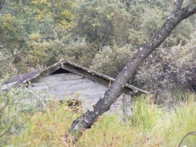
Athabascans were highly nomadic, traveling in small groups to fish, hunt, and trap.
Athabascan territory, the largest area of all the Alaska Native peoples, was home to 11 different linguistic groups who lived along five major riverways: the . . . — — Map (db m72795) HM
“Our people had log houses without nails and we all lived the same. We lived subsistence way of life, and love it that way. We have our fish houses, drying racks and all that.”
Alberta Stephan, . . . — — Map (db m72796) HM
Commercial farming of Atlantic salmon using ocean net pens is important to the economy in several areas of the Pacific Northwest, especially along the coast of British Columbia.
However, net pen fish farming has been banned in Alaska since 1990 . . . — — Map (db m70735) HM
Good Clean Livin The largest bear enclosure in the United States is found here at the Alaska Wildlife Conservation Center. Solar electricity powers the electric fence that encloses 18 acres of land, and water is pumped into the pond by the . . . — — Map (db m170904) HM
James Cook was born in Yorkshire, England, on October 27, 1728. He was apprenticed to serve on sailing ships built in Whitby, near his birthplace, to carry coal along the English coast. At age 26, he joined the Royal Navy, took part in actions . . . — — Map (db m72493) HM
1 to 4 years in fresh water
Most coho migrate to sea after one or two years in fresh water.
Sept 1-Nov 15 The adult cohos are the last of the Pacific salmon to arrive in the river to spawn.
Nov 15-April 1 The eggs incubate over the winter. . . . — — Map (db m70734) HM
This gate is dedicated to men of the Armed Forces of the United States who died while serving their country in war and in peace.---In Memory of Kermit Roosevelt. Born 1859-Died 1943-Who fought in the British and American Armies during World Wars I . . . — — Map (db m72794) WM
Measuring the Magnitude of Damage
The Good Friday Earthquake destroyed or severely restricted all forms of transportation, utilities and communications over a large part of south-central Alaska.
Communications and Utilities
The . . . — — Map (db m69766) HM
Athabascans were masters at designing a variety of shelters--simple and functional--that kept them both warm and mobile as they set out to hunt and trade.
Emergency shelters were constructed in minutes.
A wandering hunter could pile up . . . — — Map (db m72792) HM
Calves are born mid-May to early June. Cows give birth to twins 15 to 75 percent of the time and triplets occur about once in every 1,000 births.
Calves stand within minutes and begin eating vegetation a few days after birth.
Calves stay . . . — — Map (db m70720) HM
The oldest house in Anchorage was originally built in Knik, Alaska, in 1913. Oscar Gill moved his home to Anchorage in 1916. An Iditarod Trail mail musher and three term mayor of Anchorage, Gill was speaker of the territorial House of . . . — — Map (db m173886) HM
Top Predators
Eagles will prey on any animal they are capable of overtaking including ducks, gulls, porcupines, foxes and rabbits. The primary tool used to catch and kill prey are its feet. Equipped with needle sharp talons and powerful tendons, . . . — — Map (db m170902) HM
Raven is the Creator in many Alaska Native and American Indian legends. Elements from my different legends are incorporated into this sculpture including "Raven Stealing the Stars, Sun, and Moon." The human figures in the claws symbolize icons used . . . — — Map (db m72793) HM
1776
Two events destined to change the history of the world took place the first week of July 1776.
On the fourth day of July, the Representatives of the United States of America, in general congress assembled at Philadelphia, declared . . . — — Map (db m69767) HM
“And, behold … The earth did quake and the rocks rent;”
Matthew 27:51
A description of the first Good Friday
The gruesome dance of the earth finally stopped, leaving much of downtown Anchorage in ruins.
In four . . . — — Map (db m69795) HM
More devastating than the Good Friday Earthquake itself, the seismic sea waves or tsunamis, that followed caused the major loss of life and property in Alaska.
Tsunamis are generated by the sudden upward movement of the seafloor along the . . . — — Map (db m69769) HM
You are standing on the edge of the Turnagain Heights Slide, the largest and most destructive landslide in Anchorage.
Ninety seconds into the Good Friday Earthquake, an 8,000-foot strip of bluff, 1,200 feet wide began cracking apart into . . . — — Map (db m69770) HM
For generations the Inuit people of Northern Canada, Greenland, and Alaska have constructed these rock monuments for hunting and navigational purposes. Our inuksuk is a giant version based on similar monuments found throughout the Arctic. . . . — — Map (db m69768) HM
High above river valleys, at overlooks like this, Denali’s first human visitors watch for mammoth, giant bison, and caribou. Ridge tops made the best game launching platforms; herds tend to follow sheltered stream corridors.
Hunters had to . . . — — Map (db m69724) HM
Mountains in Motion
Though the visible glaciers appear remote - gleaming between distant peaks - the valley below is strewn with signs of masses glaciation: stranded boulders, gouged-out ponds, and gravel outwash plains. The last big . . . — — Map (db m71362) HM
He laid the foundation of the National Park Service, defining and establishing the policies under which its areas shall be developed and conserved unimpaired for future generations. There will never come an end to the good that he has done. — — Map (db m195774) HM
The train track along the Healy Canyon wall provides an exhilarating view down to the Nenana River below. Imagine the challenge of constructing this grade in 1921. Three tunnels at the south end of the canyon made the job a little easier by cutting . . . — — Map (db m71361) HM
Noticeable among the earliest pioneers settling in Fairbanks were prostitutes, women of the demimonde who stampeded to the new Fairbanks gold camp from Dawson, Circle City, Rampart and points beyond. In a city where men far outnumbered women, . . . — — Map (db m47404) HM
Gold discoveries brought Alaska and the Yukon to the attention of the world. A series of stampedes occurred over more than three decades. Drawn by dreams of gold, men and women from many places and all walks of life participated in an adventure that . . . — — Map (db m59836) HM
Captain E.T. Barnette, a passenger on the riverboat Lavelle Young, debarked near this site on August 26, 1901, and established a trading post which in 1902 became known as Fairbanks.
Alaska Centennial 1867-1967
State of Alaska
Governor Walter J. . . . — — Map (db m59831) HM
In Memoriam
From 1905 to 1916 at least 83 men died and 400 were injured in gold mining accidents in the Fairbanks area. Underground mining was dangerous during this pioneer era. Most died from cave-ins, falling down shafts, being struck by . . . — — Map (db m47383) HM
“Instead of row after row of empty houses (Dawson), they are building new stores. The place is alive and busy-a little too crowded when we got there.” – a tourist in Fairbanks, 1928 — — Map (db m47406) HM
In the winter of 1904, the first Fairbanks Public School was opened. Ten students finished the spring term. In the fall of 1905, the school enrolled 50 students. The next year, 150 students attended.
Construction of a much-needed new school on the . . . — — Map (db m219204) HM
Dredges were brought in to mine gold-bearing deposits in the Fairbanks mining district after 1920. This bucket-line or ladder dredge has 68 buckets, each with a capacity of 6 cubit feet. The bucket line was driven by a 150 horsepower motor that . . . — — Map (db m144242) HM
Used by President Warren G. Harding on his trip to Alaska in 1923 to drive the Golden Spike for the Alaska Railroad. “Denali" is the Indian name for Mt. McKinley, the “Great One.” — — Map (db m219066) HM
By August, 1904, when a Catholic priest arrived in Fairbanks, all choice lots in the center of town were taken. Father Francis Monroe, a Jesuit missionary, selected land at the edge of town, bordering the Chena River. The first Roman Catholic . . . — — Map (db m135350) HM
Dr. Maple was a structural engineer and principal designer of the trans-Alaska pipeline. He holds three patents for his development of innovative pipe supports that enabled the warm oil pipeline to safely traverse areas of permafrost. He pioneered . . . — — Map (db m58949) HM
Construction of the Lacey Street Theater began in 1939, and this Art Deco style building opened in 1940. Austin E. “Cap” Lathrop, Fairbanks businessman and financier, was its owner. The Lacey Street Theater, with its distinguished neon . . . — — Map (db m58989) HM
• Length: 800 miles
• Diameter: 48 inches
• Crosses three mountain ranges and more than 500 rivers and streams
• Cost to build: $8 billion in 1977, the largest privately funded construction project at that time
• Construction began March . . . — — Map (db m175383) HM
On November 16, 1973, through Presidential approval of pipeline legislation, Alyeska Pipeline Service Company received permission to begin construction of the 800-mile trans Alaska pipeline, its pump stations and the Marine Terminal at Valdez. . . . — — Map (db m20215) HM
Suter, “The Live Jeweler” and E.R. Peoples, owner of E.R. Peoples General Merchandise, married two sisters in 1910.They built these two adjoining houses, together one of the first modern homes in town. — — Map (db m47408) HM
The gold deposit found in 1902 north of present-day Fairbanks proved to be the richest in Alaska. Prospector Felix Pedro and trader E.T. Barnette played key roles in the discovery and initial rush. A second strike made the following summer . . . — — Map (db m59826) HM
In November of 1907, a two-story wooden schoolhouse with a cupola was completed on this site. Over time, to accommodate growth, the schoolhouse was expanded and additions were made. In 1932, the school was destroyed by fire, but rebuit in 1934 as . . . — — Map (db m238727) HM
Captain E.T. Barnette, whose trading post on the Chena River became the city of Fairbanks, arrived here on the sternwheeler Lavelle Young with Captain Adams on August 26, 1901.
Felix Pedro and partners, mining for gold in the hills above town, saw . . . — — Map (db m47382) HM
This Sign Greeted New Arrivals As They Arrived At The Pipeline Construction Camp Located One Mile West Of Here. We Salvaged This Sign When The Camp Was Being Dismantled.
You are about 55 miles north of the Arctic Circle on the East Bank . . . — — Map (db m49597) HM
This is the site of the original cabin of James J. Wickersham. He was an author, pioneer judge, congressional delegate and Alaska Visionary.
Alaska Centennial 1867-1967
State of Alaska
Governor Walter J. Hickel
Alaska Centennial Commission — — Map (db m47384) HM
This pole is one of two poles manufactured in 1951 as part of a campaign to properly mark the top of the Earth. After a grand tour of the United States, its twin was pushed out of the tail hatch of an Alaska Airlines DC-4 over the geographic North . . . — — Map (db m58912) HM
Fort Seward was the first permanent military base in Alaska. Completed in 1904 on 100 acres of land donated by the Presbyterian Church, it remained active until 1944. Named for William H. Seward, the U.S. Secretary of State who arranged the purchase . . . — — Map (db m70810) HM
Commemorating the Founders
of
Port Chilkoot
World War II Veterans
and their families
who bought Fort Wm. H. Seward in 1947
and pioneered their futures here.
Steve Homer • Ted and Mimi Gregg • Carl and Betty Heinmiller • Marty and . . . — — Map (db m70803) HM WM
Natives of Southeast Alaska have made totem poles such as this one for thousands of years.
This pole depicts four Haida clan stories. It was carved in 1940 by master carver John Wallace of Hydaburg. Described as "the last of the professional . . . — — Map (db m181736) HM
Two regional airlines founded here in the mid-1930's, eventually merged with Alaska Airlines. In that sense, they still serve Juneau today. Each began as a one-plane flying company.
Sheldon “Shell” Simmons' Alaska Air Transport Company was . . . — — Map (db m181843) HM
A sum of $40,000 was authorized under the Public Building Act of 1910 and construction began in 1912. Governor Walter D. Clark held the first open house January 1, 1913.
State of Alaska
Governor Walter J. Hickel
Alaska Centennial . . . — — Map (db m181739) HM
At the Alaska Juneau mill from 1917-1944, ore was sorted, crushed, and treated to extract gold. Electric-powered engines hauled trains of 40 ore cars along the main haulage route form the mine two miles away in Silver Bow Basin to the AJ mill, . . . — — Map (db m42823) HM
Monument against east wall of house off Whittier Way:
This memorial is dedicated to all
Alaska Native Veterans,
Southeast who served in the
United States Armed Forces. Let us not dwell on their passing
but remember their . . . — — Map (db m69127) WM
built September 16, 1913
has been placed on the
National Register
of Historic Places
by the United States
Department of the Interior — — Map (db m181762) HM
Born: 17 March 1925 Juneau, Alaska. Died: 22 May 1986 Ketchikan, Alaska
Sudong, Korea 2 November 1950-For conspicuous gallantry and intrepidity at the risk of his life above and beyond the call of duty as a platoon sergeant in Company B-1-7, 1st . . . — — Map (db m61871) WM
Because Juneau cannot be reached by road, the waterfront has always been Juneau's doorway to the outside world. Today travelers and freight continue to arrive at this waterfront by sea and air.
The first vessels on the Gastineau Channel were the . . . — — Map (db m181775) HM
"I love this country and the ideals upon which it was founded…More than anything else, I care about the men and women who make up our military forces…I do not want to see them either kill or be killed in a war that is not moral or . . . — — Map (db m181757) HM
Built by the Civilian Conservation Corps — 1935
Olaf Torkelson, Juneau Street Commissioner from 1924-1936, was instrumental in the success of this project. The overpass was built to provide safe access for children who attended Capital School . . . — — Map (db m181738) HM
The Cape Decision lighthouse was the last one built in Alaska. Need for it grew as ship traffic and the size of the ships increased. Southeast Alaska was booming with many salmon canneries, herring salteries and whale oil reduction plants. Large . . . — — Map (db m181646) HM
Perched high on a cliff, Cape Hinchinbrook lighthouse marks the entrance to the sheltered waters of Prince William Sound. The wreck of the steamer Oregon on Hinchinbrook Island in 1906 prompted the light's installation. Foul weather during . . . — — Map (db m181634) HM
Facing the open Gulf of Alaska, Cape Saint Elias lighthouse stands on Kayak Island, where in 1741, Russian voyagers first set foot on North American soil. The Cape's bald pinnacle serves as a key landmark in daylight. The light provides guidance at . . . — — Map (db m181632) HM
Scotch Cap and Cape Sarichef lighthouses mark the north and south entrances to Unimak Pass in the Aleutian Islands. Both sites were declared to be too isolated for family life.
Scotch Cap was the first light on Alaska's outside coast and is the . . . — — Map (db m181636) HM
Cape Spencer lighthouse stands on a barren, isolated rock at the entrance to Cross Sound, where the sheltered Inside Passage meets the open Gulf of Alaska. The original lighthouse still stands. It is a single-story, reinforced concrete building that . . . — — Map (db m181631) HM
Eldred Rock is the oldest original lighthouse still standing in Alaska. It is a two-story building topped by a light tower. The ground floor was built of reinforced concrete, the first time that material was used for a lighthouse facing Alaska's . . . — — Map (db m181635) HM
Southeast Five Finger was the first name given this lighthouse site due to its location on the southeastern-most island of the Five Finger Islands group. The original, wood boathouse and carpenter shop remain.
A keeper thawing frozen water pipes . . . — — Map (db m181645) HM
The waterfront was the center of regional air transportation because float-planes were so well-suited for reaching the outlying places they served. There is little flat terrain in Southeast Alaska, and it was hard to find a place for a wheeled . . . — — Map (db m181803) HM
Although most materials needed by the historic mining industry came in downtown, one important commodity was off-loaded at the Dupont Dock, about 5 miles south of town. Dynamite was considered too much of a threat to deliver to the town's commercial . . . — — Map (db m181783) HM
A square, white wooden tower housed the Guard Islands light, with a separate keeper's house nearby. When a reinforced concrete building replaced the old light tower in 1922, a second house was built so two keepers could live there with their . . . — — Map (db m181640) HM
This bronze sculpture was commissioned by the city and borough of Juneau during its centennial anniversary year, and is dedicated to the mine whose work provided the lifeblood of Juneau during it first six decades.
In the late 1800’s, compressed . . . — — Map (db m42809) HM
This totem pole tells the story of the harnessing of the atom. The pole was carved in 1967 by Tlingit carver Amos Wallace of Juneau. His Tlingit name was Jeet Yaaw Dustaa of the T'akdeintaan Clan of the X'áakw Hít Tlingit (Freshwater-marked Coho . . . — — Map (db m181737) HM
Will Rogers & Wiley Post. Wiley Post was a famed aviator who, in 1935, flew into Juneau with Will Rogers, a humorist much loved by the American public. The two friends were on a private adventure trip in Post's plane. After spending several days in . . . — — Map (db m181846) HM
This reproduction of the Liberty Bell was placed on permanent display at the Treasury by direction of Secretary of the Treasury John W. Snyder. It is a duplicate of the original Liberty Bell in tone as well as in structural details and . . . — — Map (db m70759) HM
For more than 100 years, lighthouses have guided mariners through Alaskan waters.
Lighthouses capture our imagination as lonely sentinels of the sea. They played a vital role in Alaska's development because for more than 70 years, ships . . . — — Map (db m181647) HM
Widely spaced along Alaska's Inside Passage, these three lighthouses were among the first built, and the first discontinued.
The lighthouse on Lincoln Rock, near Ketchikan, was unusually difficult to build. The small, rocky pinnacle on which it . . . — — Map (db m181637) HM
Between 1929 and 1932, passengers could fly between Juneau's waterfront and downtown Seattle on scheduled weekly flights of Alaska-Washington Consolidated Airways. The fare was $105.
Juneau's harbor was home to three pioneer flying companies that . . . — — Map (db m181821) HM
Panel 1:
The City and Borough of Juneau Assembly Honors the Contributions of Filipinos in Juneau by naming this downtown location MANILA SQUARE
Juneau Assembly Members: Dale Anderson - Don Etheridge, Jr. - Jeannie Johnson - Ken . . . — — Map (db m68849) HM
Local ferries once plied a triangular route linking Juneau, Douglas, and Thane. These three communities, each centered on a major mine, eventually merged into one. In 1935, a bridge was constructed linking Douglas Island with the mainland.
In . . . — — Map (db m181794) HM
The lighthouse on Mary Island is the second one seen by ships heading up Alaska's Inside Passage. The beacon guides mariners into Revillagigedo Channel leading to Ketchikan. Like most of Alaska's lighthouses, it was built soon after the Klondike . . . — — Map (db m181642) HM
Steamships brought passengers as well as goods. During the heyday of steam travel, there was a ship at the dock almost every day. In 1918, the Canadian Pacific Line's Princess Sophia was bound for this harbor when the ship foundered on a reef . . . — — Map (db m181792) HM
Ships arriving in Juneau in the 1930's could count on being met at the dock by a small, white dog named Patsy Ann. A local dentist, Dr. E.H. Kaser, brought the English bull terrier as a puppy from Portland, Oregon in 1929. Although loved and . . . — — Map (db m181734) HM
Fifty years after Patsy Ann met her last ship, admirers led by June Dawson organized the Friends of Patsy Ann. The group raised funds and commissioned a statue so Patsy Ann could once again greet visitors on the dock.
Sculpted by Ann Burke . . . — — Map (db m69663) HM
The red-roofed, white buildings at Point Retreat are a familiar sight to local boaters and passengers on cruise ships sailing between Juneau and Glacier Bay. The original, wooden light tower at Point Retreat was only 6 feet tall, but it stood 19 . . . — — Map (db m181638) HM
Sentinel Island Lighthouse guards the entrance to Favorite Channel, linking Lynn Canal to Juneau's Auke Bay. The original, wood frame structures included a keeper's house with an attached light tower and out-buildings, including a wharf and . . . — — Map (db m181644) HM
Visionary
An ardent expansionist, Seward pursued his vision of “Manifest Destiny” to expand the borders of the United States through peaceful means. Some of his interests included a port in the Caribbean, Hawaii, Guam, British Columbia, and . . . — — Map (db m181745) HM
A building rich with history
Juneau’s gold rush in the 1880s initiated efforts by various missionaries to convert the Native peoples to their faith. American missionaries were instructed to suppress the use of native languages and as a . . . — — Map (db m70758) HM
The Alaska Juneau (AJ) mine operated from 1917 to 1944, producing 90 million tons of gold bearing ore, and was one of the largest mines in the world at the time. In the 1930's the AJ mine employed around 1000 people, produced 12,000 tons of ore per . . . — — Map (db m181772) HM
Carved by Tlingit carvers:
Charlic Tagook — Klukwan
William Brown — Saxman
Carving began in 1939 / Carving was completed in 1940
Featured on this totem pole, from top to bottom, are Raven, a man, a giant cannibal (Guteel), . . . — — Map (db m181740) HM
has been placed on the
National Register
of Historic Places
by the United States
Department of the Interior
built • restored
1925 • 2000 — — Map (db m181759) HM
Tree Point is Alaska's most southerly of the Southeast lighthouses. It marks the first landfall for northbound ships crossing Queen Charlotte Sound, 30 miles of coastal water open to the Pacific. Mariners used Tree Point Lighthouse to guide them . . . — — Map (db m181641) HM
The U.S. Navy's arrival in Juneau quickly followed the discovery of gold. Upon receiving word of the 1880 strike, the navy dispatched a steam launch, which anchored in the harbor. Disembarking here was a naval detachment under the command of Lt. . . . — — Map (db m181802) HM
Center Marker Panel: [Rendering of the cruiser USS Juneau(CL-52)]
'Lest We Forget'
The Naval Battle of Guadalcanal was as ferocious and decisive as any battle of World War II. It was not won cheaply. The night action of Friday . . . — — Map (db m77160) WM
Waterfront cold storage buildings supported the fishing industry while warehouses stored the freight that came and went. All goods coming into town — from the nuts and bolts of industry to walnuts and bolts of calico — were offloaded here. Outbound . . . — — Map (db m181784) HM
This statue was erected in 2017 to commemorate the 150th anniversary of the Treaty of Cession that was negotiated with Russia by Seward, resulting in the transfer of Alaska to the United States.
Seward is considered to be among the most important . . . — — Map (db m181743) HM
Family and Early Political Life
William Henry Seward was born in Florida, New York, on May 16, 1801. His father, a wealthy landowner, was a slaveholder prior to New York abolishing slavery in 1827. Seward would later become instrumental in . . . — — Map (db m181752) HM
Pelton wheels are among the most efficient types of water wheels. It was invented by Lester Allan Pelton (1829-1908) in the 1870s, and is an impulse machine, meaning that it uses Newton’s second law to extract energy from a jet of fluid. It . . . — — Map (db m70762) HM
In 1880 a local inhabitant, Chief Kowee, revealed to prospectors Joe Juneau and Richard Harris the presence of gold in what is now named Gold Creek in Silver Bow Basin. The city of Juneau was founded there that year. The strike sparked the Juneau . . . — — Map (db m70765) HM
Prospectors found gold in 1895 under the present Canyon Creek Highway Bridge and on Mills Creek. Those discoveries launched a rush to Turnagain Arm more than a year before the Klondike Gold Rush.
Prospectors Poke Around
After gold was . . . — — Map (db m49599) HM
Beatrice Greene; the last working woman
For half a century, this house, like so many on the Creek, was part of Ketchikan’s notorious red light district where both fish and men came upstream to spawn… the fish once, many of the men . . . — — Map (db m112041) HM
The cultural traditions and stylistic glories of Northwest Coast Native artists go back centuries. But the historical period of (obscured) and curating — mainly by non-Natives — is relatively short. Totem poles by tradition were private . . . — — Map (db m182030) HM
Ketchikan's notorious Creek Street, early Alaska's most infamous red-light district, still retains traces of the gaudy rouge of a half-century of speakeasies and sporting women. Here the fame of Black Mary, Thelma Baker and Dolly Arthur . . . — — Map (db m182103) HM
Totem poles are carved to honor deceased ancestors, record history, social events, and oral tradition. They were never worshipped as religious objects.
This totem, carved by Israel Shotridge and raised in 1989, is a replica of the Chief . . . — — Map (db m79703) HM
187 entries matched your criteria. The first 100 are listed above. The final 87 ⊳