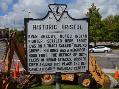
Evan Shelby, noted Indian fighter, settled here about 1765 on a tract called "Sapling Grove". His home was a neighborhood fort, the refuge of settlers in Indian attacks. Bristol grew around this place and became an early railroad center. — — Map (db m24323) HM
Nearby to the south stood Fort Christanna, a wooden structure built in 1714 under the auspices of Alexander Spotswood and the Virginia Indian Company. Members of the Meiponsky, Occaneechi, Saponi, Stuckenock, and Tutelo Indian tribes lived within . . . — — Map (db m20181) HM
A community of mills, warehouses, homes and stores sprang up with the construction of the Atlantic and Danville Railway in the 1890s. A combination freight and passenger station was located at Brodnax shown here in 1948. Bales of cotton, timber and . . . — — Map (db m94357) HM
Brunswick County. Formed in 1720 from Prince George, Surry, and Isle of Wight. Named for the House of Brunswick, which came to the throne of England in 1714, when George I was crowned king. Colonial Fort Christanna was in this county. . . . — — Map (db m60468) HM
In 1714, at Governor Alexander Spotswood’s urging, the Virginia General Assembly funded the Virginia Indian Company, charged with building a fort on the banks of the Meherrin River in what would become Brunswick County. The fort would provide . . . — — Map (db m20197) HM
Nearby to the south stood Fort Christanna, a wooden structure built in 1714 under the auspices of Alexander Spotswood and the Virginia Indian Company. Members of the Meiponsky, Occaneechi, Saponi, Stuckenock, and Tutelo Indian tribes lived within . . . — — Map (db m20184) HM
A Fort Called Christ-Anna
You are standing at the site of Fort Christanna, a colonial fort laid out in 1714 by Virginia’s Governor Alexander Spotswood. The fort was built on a tract of land set aside in 1714 for a trading post, as well as a . . . — — Map (db m20199) HM
Alexander Spotswood (1676-1740) was Governor of Virginia from 1710 to 1722. Born in Africa of a Scottish family, he had distinguished himself at the Battle of Bleinheim and was wounded. He was appointed to the governor’s position in Virginia in . . . — — Map (db m20200) HM
The story of Native Americans after Jamestown's founding in 1607 is a tragic one. At that time the Siouan Indians of Virginia probably numbered 6,300 people. By 1714, when Fort Christanna was established, they were in difficult circumstances, being . . . — — Map (db m20198) HM
In 1924 the National Society of the Colonial Dames of America in the Commonwealth of Virginia acquired three and three-quarters acres of land on which the fort was presumed to have been built, then erected a monument of concrete embedded with . . . — — Map (db m20202) HM
At Birch's Bridge (very near this bridge) the second William Byrd and his party crossed the river, in September, 1733, on their way to inspect Byrd's land holdings in North Carolina. Byrd wrote an account of this trip which he called “A . . . — — Map (db m62403) HM
Buckingham County. Area 584 square miles. Formed in 1761 from Albemarle, and named for Buckinghamshire, England. Peter Francisco, noted Revolutionary soldier, lived in this county.
Cumberland County. Area 293 square . . . — — Map (db m21134) HM
Two miles east is Shady Grove, which was built in 1825 by Dr. George Cabell, of Point of Honor in Lynchburg, for his daughter Paulina and her husband Alexander Spotswood Henry, son of Patrick Henry. Shady Grove is a handsomely proportioned and . . . — — Map (db m64247) HM
Two miles north stand massive sandstone walls and four chimneys, the ruins of Mount Athos, overlooking a bend of the James River. The house was built about 1800 for William J. Lewis (1766-1828) on land that had been patented in 1742 by John Bolling . . . — — Map (db m42896) HM
Rustburg was named after Jeremiah Rust, who patented land here in 1780. Rust donated 50 acres of land, known as Rust Meadows, in 1784, for the county seat of Campbell County. A temporary courthouse and other public buildings were constructed . . . — — Map (db m65564) HM
In 1754, John and Ann Rogers Clark, with their sons Jonathan and George Rogers, moved from Albemarle County to a farm four miles west. There were born Ann, John, Richard, Edmund, Lucy, Elizabeth, William and Frances. During the Revolutionary War, . . . — — Map (db m9215) HM
The daughter of Richard and Elizabeth Buckner and the widow of Charles Smith, Dorothy Smith married John Roy in 1719. John Roy was the owner of a tobacco warehouse at Port Royal, Virginia - a facility to which local planters brought their tobacco to . . . — — Map (db m57538) HM
The town was established in 1744 and was one of the principal shipping points on the Rappahannock River in colonial times. In December, 1862, Burnside, commanding the Army of the Potomac, considered crossing the river here but finally moved up to . . . — — Map (db m21457) HM
Following the first treaties between the English and the Powhatan confederacy, colonial settlement expended up the Rappahannock River. One of the earliest land patents was held by Col. John Catlett. In 1670 he was killed defending the small . . . — — Map (db m133746) HM
Born in 1837, “Aunt” Orelena Hawks Puckett lived here during the latter of her 102 years. She was often heard to say, “The forest was green when I was a-born and I'm green yet.” A bride at 16, Puckett and her husband first . . . — — Map (db m125194) HM
This community acquired its name from the Barnett family and was once a major commercial center for the western end of the county. The area has been served by the post offices of Bradley's Store (1879-1911) and Barnett's (est. 1911). At the time of . . . — — Map (db m29154) HM
A short distance south. The place was first settled in 1619 but was abandoned. It was repatented in 1636. Benjamin Harrison, signer of the Declaration of Independence, lived here; his son, William Henry Harrison, President of the United States, was . . . — — Map (db m30225) HM
A short distance south, it was first settled in 1619, when the first Thanksgiving was held here. The present mansion, built in 1726, was the birthplace of Benjamin Harrison, signer of the Declaration of Independence, and President William Henry . . . — — Map (db m9284) HM
English settlers established Berkeley Hundred just south of there in 1619. Benjamin Harrison III, a merchant and planter, purchased the property in 1691. A Georgian-style house was built in 1726 for Benjamin Harrison IV and his wife, Anne Carter. . . . — — Map (db m175928) HM
From Prestwood, England
At Jamestown 1608
First Governor of Berkeley
Hundred Plantation 1619
Capt. John Woodliffe and 38 settlers
in the Ship "Margaret" landed here
December 4, 1619
First Official Thanksgiving Day
Service in . . . — — Map (db m209104) HM
(left panel)
Gateways to Exploration
Four centuries ago, English eyes searched this landscape for a place to build a fort. Three English ships: the Susan Constant, the Godspeed, and the Discovery had crossed the Atlantic and . . . — — Map (db m89565) HM
(left panel)
Gateways to Conflict
As the English began to establish settlements up river from Jamestown, they chose prime agricultural spots known as Indian fields that had been cleared and were still in use by the Natives. . . . — — Map (db m89566) HM
(left panel)
Sustaining a Credible Illusion
The Jamestown settlement was facing a severe food shortage in November of 1607. Captain John
Smith set out to trade for corn with the Indians living along this river. He traveled from . . . — — Map (db m46511) HM
Originally part of William Byrd's Westover, Evelynton has been occupied by the Ruffin family since 1847, when it was purchased by Edmund Ruffin, Jr. Fierce skirmishes took place on the property during the 1862 Peninsula Campaign. Confederate troops . . . — — Map (db m9404) HM
The Herring Creek area was settled in 1619, as a portion of Westover, and a portion of Berkeley Hundred. The point where the James River Road, present-day Route 5, crossed Herring Creek was known as "The Wade." Landmarks have included Harrison's . . . — — Map (db m9288) HM
The Chickahominy Indians resided near here along the river that bears their name. This area was part of Wilmington Parish and was part of James City County before 1720. In the 1800s the community acquired the name of the Holdcroft family. Mt. . . . — — Map (db m18657) HM
(panel 1)
John Smith Explores the Chesapeake
Captain John Smith explored the Chesapeake Bay in the early 1600s seeking precious metals and a passage to Asia. He traveled the James, Chickahominy, and York rivers in 1607, and led . . . — — Map (db m89568) HM
Colonial home of Dr. William Rickman, Head Surgeon of the Continental Army of Virginia, and wife Elizabeth Harrison Rickman Edmondson, of Berkeley.
Original section constructed ca. 1770-1790, shed roof addition added ca. 1840.
Land . . . — — Map (db m59621) HM
A mile and a half northwest, Lott Cary was born in slavery about 1780. In 1804 his owner, John Bowry, a Methodist minister, hired him out to a Richmond tobacco firm. Cary joined the First Baptist Church in 1807. He purchased his freedom and became a . . . — — Map (db m26338) HM
These communities were established on opposite banks of Morris Creek , earlier known as Tanks Pasbye hayes the Indian name, Moyses Creek after Theodore Moyses who patented land there, and as Moses Creek. Before 1720 this area was part of James City . . . — — Map (db m26333) HM
This community was the site of a Quaker settlement in the eighteenth century and the Weyanoke Quaker Meeting House and graveyard. The meetinghouse was the Upper Quarter gathering place for the Yearly Meeting of Virginia Quaker. The area has since . . . — — Map (db m26328) HM
Located nearby was the main town of the Paspahegh Indians, tributaries to paramount chief Powhatan. When Jamestown was built in their territory, the Paspahegh consistently resisted the English settlement. In Aug. 1610, George Percy, on orders from . . . — — Map (db m23610) HM
During the 18th century this property was established as a Southall family seat. Notable family members include James Barrett Southall, owner of Williamsburg's Raleigh Tavern, Turner Southall, member of the committee to build Thomas Jefferson's . . . — — Map (db m18588) HM
From this spacious dwelling Colonel William Byrd, the Second, of Westover, set out in 1737 to lay the foundations and to project the future of the City of Richmond. Its grateful citizens, recalling the sufferings borne and the glory experienced, the . . . — — Map (db m30236) HM
Roxbury was named for a nearby plantation in New Kent County and reached by Longbridge over the Chickahominy. This community was the site of a colonial era tavern and the only railroad station in Charles City County . Roxbury post office (1883-1953) . . . — — Map (db m29158) HM
This area was one of the centers of Charles City's free black community before the Civil War and was named for Ruth Brown with the establishment of the post office in 1880. Abraham Brown, a major landowner of the area, founded Elam Church in 1810, . . . — — Map (db m26334) HM
John Tyler purchased this plantation one mile west in his native Charles City in 1842 while serving as tenth president of the United States, and made it his home from 1845 until his death in 1862. Tyler lengthened the wooden 18th-century house to . . . — — Map (db m9518) HM
The house a short distance south, Shirley was first occupied in 1613 and was known as West-and-Shirley Hundred. In 1664, Edward Hill patented the place, which was left by the third Edward Hill to his sister, Elizabeth Carter, in 1720. Here was born . . . — — Map (db m9602) HM
Kennons originally took its name from the plantation of the Kennon family. Kennons Creek, earlier known as David Jones Creek, served as a boundary for the earlier Wallingford Parish. Kennons Landing was the terminus for the Meadow Road, as well as . . . — — Map (db m9525) HM
This area was settled before 1622 by George Shinehow. Tobacco warehouses and docks were located at Swineyards and Willcox Wharf. A post office was established at Swineyards in 1848 and later located at Willcox Wharf. Landmarks have included Bethany . . . — — Map (db m9405) HM
In 1619 the first settlement was made at Westover, about 2 miles southeast. Two settlers died in the Powhatan uprising of 1622. Theodorick Bland bought Westover in 1666; William Byrd I acquired it in 1688. About 1730 his son, Colonel William Byrd . . . — — Map (db m9285) HM
Originally home to the Paspahegh Indians, Sandy Point was settled in 1617 as Smith's Hundred and after 1619 known as Southampton Hundred. St. Mary's Church was established here prior to the Powhatan Uprising of 1622. During the Revolutionary War . . . — — Map (db m9467) HM
Wayside was settled after 1613 as part of West and Sherley Hundred. Landmarks have included St. John's Church, established in 1897 by the Rev. John Jones, a post office at Shirley and the Shirley Mill. In 1921 the Wayside Community Club assisted in . . . — — Map (db m9252) HM
Eight miles west on "The Old Main Road" is Piney Grove. The original portion, built ca. 1800 on Southall's Plantation, is a rare survival of Tidewater log architecture. Edmund Archer Saunders, a successful Richmond businessman, operated a store at . . . — — Map (db m9506) HM
Three miles south is North Bend, a Greek Revival residence built in 1819. Sarah Minge, sister of President William Henry Harrison, and her husband, John, built the original portion of the house located on Kittiewan Creek. Thomas H. Wilcox greatly . . . — — Map (db m9431) HM
The historic district, a rare example of a 19th-century rural courthouse town, is concentrated on two main streets. Begun as Dalstonburg in 1775 during the French and Indian War, and later called Marysville and Smithville, the town was named . . . — — Map (db m31022) HM
Six miles south is Cub Creek Presbyterian Church, the oldest church in this section. The neighborhood was known as the Caldwell Settlement for John Caldwell, grandfather of John C. Calhoun of South Carolina. About 1738 he brought here a colony of . . . — — Map (db m66062) HM
Cub Creek Presbyterian Church, the oldest church in this area, stood four miles southwest of here. The neighborhood was known as the Caldwell Settlement for John Caldwell, great grandfather of U.S. senator and vice president John C. Calhoun, of . . . — — Map (db m182500) HM
Charlotte County. Area 496 Square Miles. Formed in 1764 from Lunenburg, and named for Queen Charlotte, wife of King George III. Patrick Henry and John Randolph of Roanoke lived in this county, and Henry is buried here. . . . — — Map (db m66002) HM
Nine miles west is Roanoke, home of John Randolph, a member of the House of Representatives for many years, and Senator. Randolph at first was Jefferson's lieutenant and later on an opponent and critic, but he never lost the love of his . . . — — Map (db m31860) HM
Welcome to Historic Charlottesville
Charlottesville's rich historic legacy creates the City's unique sense of place and represent one of its primary economic and cultural asset. The City's character-defining historic resources include the . . . — — Map (db m170659) HM
George Nicholas, Albemarle County’s Virginia General Assembly delegate in 1783, built a stone house here in 1784. James Monroe occupied it 1789-1790, while improving the dwelling at his nearby farm, later the site of the University of Virginia. Here . . . — — Map (db m19830) HM
The Foster family kept their ancestors close. Sheltered on a portion of their 2 1/8-acre plot purchased in 1833 by free black Catherine Foster, this burial ground still contains several dozen graves.
Rediscovered in 1993, the Foster cemetery . . . — — Map (db m81599) HM
At this place, on the site of Catherine Foster's home, this "shadow catcher" links the visible with the unseen even as it pulls the eyes upward to the sky. It creates a shadowy, gridlike outline of the house that once stood at this location. . . . — — Map (db m81598) HM
The Farm stands on a 1020-acre tract acquired by Nicholas Meriwether in 1735 and later owned by Col. Nicholas Lewis, uncle of Meriwether Lewis. A building on the property likely served as headquarters for British Col. Banastre Tarleton briefly in . . . — — Map (db m19582) HM
Poverty and prejudice shaped the lives of African Americans in Charlottesville. In the 1920s African Americans made up 28 percent of the town's population but owned only 6.5 percent of its real estate. Many lived crowded together in very small . . . — — Map (db m170153) HM
Though he owned his home, Holt still had to contend with society's prejudice and unfairness. In 1929 Charlottesville adopted its first zoning ordinance. The city forbade business and industry from encroaching on residential neighborhoods, but did . . . — — Map (db m170156) HM
By 1900 the young Charles B. Holt had left his father's farm and moved to Charlottesville. Holt's skills and determination as a carpenter, builder, and entrepreneur helped him save enough money to buy land and build his home. — — Map (db m170163) HM
You are standing on land once inhabited by the Monacan Indians and bison. While much of the landscape has changed, the Rivanna River still runs through, connecting past to present.
1733. The property first came into European hands in a . . . — — Map (db m172972) HM
To the west is the 80 acre Woolen Mills Village National Historic District. This district was recognized as a Virginia Landmark December 17, 2009 and added to the National Registry of Historic Places April 12, 2010.
Located at the foot of . . . — — Map (db m172947) HM
The Great Bridge village evolved to your left, where a bridge spanned the Elizabeth River. An early battle of the Revolution occurred around the bridge on December 9, 1775. The village grew with the completion of the Albemarle & Chesapeake Canal. . . . — — Map (db m211246) HM WM
In 1908, the first long-term Polish settlement in Virginia was established in Norfolk County, now Chesapeake. The Piast colony, named for Poland’s first royal dynasty, was called Sunray after the Virginia Railway Company depot that opened here in . . . — — Map (db m76793) HM
Established 1613 by Sir Thomas Dale.
First incorporated Virginia town 1614.
Home of John Rolfe, colony recorder, who married Pocahontas.
Rev. Alexander Whitaker ministered here.
Early port of Richmond.
Erected … 1938 by Bermuda Hundred . . . — — Map (db m17109) HM
Before determining to settle at Jamestown, the English sought a safe place to plant their colony further west along the James River. On that trip, John Smith and his fellow Englishmen found an Appamattuck Indian town in the vicinity of Bermuda . . . — — Map (db m17134) HM
The story of Dutch Gap demonstrates the importance of the river throughout history revealing a partnership of man’s use of land and water. Today, the river’s commercial and recreational activities continue, providing a backdrop to Dutch Gap’s . . . — — Map (db m16159) HM
On March 22, 1622, the Powhatan chiefdom launched a coordinated offensive against the English settlements along the James River. Sixty-six men, women and children were killed within the Henrico settlements including five dead at Henricus. Over . . . — — Map (db m87591) HM
Colonel Thomas Lygon, who came to the Virginia colony in the early 1640s from Worcestershire, England, patented several large parcels of land on the north bank of the Appomattox River in an area known as The Cowpens, near Mount My Lady, which was . . . — — Map (db m17131) HM
1611 Sir Thomas Dale and his men, using a tactic developed in the Dutch Low Country, dug a ditch and erected a fence across the neck of the peninsula for the defense of Henricus.
1864 Federal forces under General Benjamin Butler began . . . — — Map (db m87885) HM
The trail at Dutch Gap traces the old channel of the James River. Before the river was rerouted, there was a ferry landing on the opposite shore called Osborne’s Landing. This may have been the location of the enigmatic Port Cotage referenced by . . . — — Map (db m87594) HM
In 1611, Farrar's Island was the site of the "Citie of Henrico," one of Virginia's first four primary settlement areas under the Virginia Company of London. Later, it was part of a 2,000-acre land patent issued posthumously to William Farrar in . . . — — Map (db m16018) HM
The Colonial Dames
Of America in the
State of Virginia
A.D. 1910
Erect this monument on the site
Of the Town of Henricopolis
To commemorate the college
And university which on
May 26, 1619.
The Virginia Company of
London decreed . . . — — Map (db m16149) HM
Near this spot, the Arrohateck Indians greeted John Smith and his compatriots during their May 1607 exploration upriver from Jamestown. Smith’s 1612 Map of Virginia shows Arrohateck towns on both shores of the James below present-day Richmond. . . . — — Map (db m16335) HM
Mt. Malady, the first hospital in the American colonies, was built in Coxendale near Henricus in 1612. It had 40 beds for 80 patients! Many colonists arrived in poor health from their long sea voyage. Others acquired diseases, such as . . . — — Map (db m87884) HM
In 1607, Opposunoquonuske, sister of the Appamattuck Indian chief Coquonasum, headed an Appamattuck town on the James River at the mouth of the Appomattox. On 24 May 1607, Opposunoquonuske received a party of Englishmen in a stately fashion, greatly . . . — — Map (db m54254) HM
The town of Osbornes was named for Captain Thomas Osborne who settled nearby at Coxendale in 1616. During the 17th and 18th centuries, Osborne's plantation wharf was a tobacco inspection station and local shipping center. Thomas Jefferson, . . . — — Map (db m16019) HM
Near this spot was built
Anno Domini 1611
The Church of Henricopolis
Under the auspices of
Sir Thomas Dale
High Marshall of Virginia
The Reverend Alexander Whitaker, M.A,
Minister
This cross is erected to
Commemorate the . . . — — Map (db m16147) HM
Native Americans 1500's
These boats were used by the Powhatan Indians to carry furs, food, and other trading items.
First Settlers 1600's
Shallops were wider and sometimes longer than canoes. They were propelled by oars or by . . . — — Map (db m87886) HM
Two and one-third miles south stands Eppington, built in the late 1760s by Francis Eppes and his wife Elizabeth Wayles Eppes, half-sister to Martha Wayles Jefferson. Thomas Jefferson frequently visited Eppington. Lucy Jefferson, his daughter, died . . . — — Map (db m28911) HM
Free enterprise had its beginnings in the New World on this site in 1611. Sir Thomas Dale, following orders from the London Company to "find a more beautiful place," moved westward from Jamestown and built a town out of the wilderness.
The . . . — — Map (db m149631) HM
You are now on Farrar's Island. Here in 1611, Sir Thomas Dale established the "Citie of Henryco", one of Virginia's first four primary settlement areas under the Virginia Company of London. Later, this land was part of a 2,000-acre patent issued . . . — — Map (db m149633) HM
As the small band of Jamestown colonists explored the upper reaches of the tidal James River in May 1607, they stopped twice at the town of Arrohateck, home to an estimated 255 Algonquian-speaking natives. On both occasions they were welcomed by . . . — — Map (db m149628) HM
Dr. Pastore learned of the presence of Mt. Malady, the first hospital in North America, situated at the 1611 Citie of Henricus. He developed the concept of its reconstruction, promoted local interest in the project, acquired various parcels of . . . — — Map (db m149630) HM
The site of an Appomattox Indian village burned in 1676 in Bacon's Rebellion, the present town of Ettrick stands on land that belonged to "Ettrick Banks" and "Matoax," the boyhood plantation of John Randolph of Roanoke. In 1810 Campbell's Bridge . . . — — Map (db m14622) HM
A mile north, on the site of an important Appamatuck Indian village, Sir Thomas Dale established Bermuda Hundred in 1613. The hundred was a traditional English jurisdiction of one hundred families. Dale, the deputy governor and marshal of Virginia, . . . — — Map (db m11662) HM
In 1700-1701, Huguenots (French Protestant refugees) settled in this region on land provided to them by the Virginia colony. The Huguenot settlement, known as "Manakin Town" centered at the former site of a Monacan Indian town, located south of the . . . — — Map (db m31544) HM
Local Coal Mining in the 18th and 19th Centuries
Outcroppings of coal along the south bank of the James River in what is now Powhatan County were discovered circa 1700. A hunter from the nearby Huguenot settlement, Manakintown, dislodged . . . — — Map (db m31569) HM
Mattoax was located to the south on the Appomattox River. John Randolph, Sr., built a house there in the 1770s that burned after 1810; it was the boyhood home of his son, John Randolph of Roanoke. Mattoax also was the residence of St. George Tucker, . . . — — Map (db m19637) HM
The history associated with Falling Creek Park spans more than 400 years. Numerous industries existed along the creek from the 17th to the early 20th century.
The earliest industry that existed at this location was the first iron furnace . . . — — Map (db m101036) HM
Vanished now but for a trace, Falling Creek is the site of the first industrial ironworks in the New World. The close proximity of iron ore, wood for fuel and power provided by the falling water made the Falling Creek site perfect for this . . . — — Map (db m32587) HM
Located at this site was the beginning of one of the earliest residential communities in Chesterfield County.
Historic Village Of Bensley
Created by Albert Bensley in 1909, the Village of Bensley was marketed as a modem, convenient . . . — — Map (db m101037) HM
Located eight miles downstream from Richmond, Warwick was an important 18th-century James River port and manufacturing center. During the Revolutionary War, Warwick's craftsmen turned out clothing and shoes, and its mills ground flour and meal for . . . — — Map (db m16014) HM
The house to the north is the home of Nellie Parke Custis, George Washington’s ward, who married his nephew, Major Lawrence Lewis. After her husband’s death in 1839, Nellie Custis Lewis settled here, and here she died in 1852. — — Map (db m69004) HM
Benjamin Berry, son of Henry Berry of King George County, settled in what is now Clarke County prior to the Revolution, and in 1798, he procured the formal establishment of the town of Berryville, the town having been platted by him, and consisting . . . — — Map (db m1810) HM
Initially known as "Battletown" for the Saturday night brawls that took place at the local inns, the town of Berryville was officially chartered in 1798 and named for Benjamin Berry, a local businessman. The new town became the county seat when . . . — — Map (db m157717) HM
1637 entries matched your criteria. Entries 201 through 300 are listed above. ⊲ Previous 100 — Next 100 ⊳