Local citizens formed the Town of Potomac on March 13, 1908, to provide better services and promote growth. Taxes paid for police and public works projects, such as water and sewer service to replace polluted wells and outhouses. Electric . . . — — Map (db m146442) HM
English settlers built several plantations on the site in the 18th century. The land, much owned by the Swann and Daingerfield families, became part of Alexandria County, D.C. with the creation of the District of Columbia in 1791, and retroceded . . . — — Map (db m115145) HM
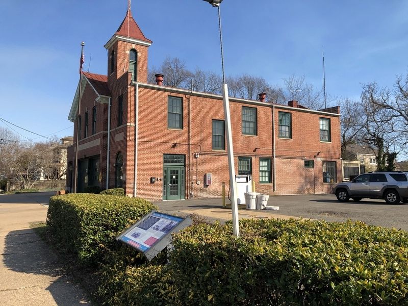
Rosemont began as a streetcar suburb just outside the City of Alexandria. It remains an excellent example of this type of early 20th century development. By 1908, investors from Philadelphia; Washington, D.C.; and northern Virginia — operating as . . . — — Map (db m191970) HM
Potomac Yard was once part of a vast, wooded landscape overlooking the Potomac River. The original 6,000-acre tract (about 9 square miles) was passed down through generations of the John Alexander family and divided among surviving spouses and . . . — — Map (db m115672) HM
When Native Americans moved into the Mid-Atlantic region of the United States they traveled on the waterways created overland routes for hunting, migration, and trade. In essence, they were Virginia's first highways. These routes often followed . . . — — Map (db m115675) HM
(North Side):
This monument marks the trail taken by the army of General Braddock which left Alexandria on April 20, 1755 to defend the western frontier against the French and Indians.
Erected by the Society of Colonial Dames of . . . — — Map (db m7567) HM
African Americans established "The Fort," a community that continued here after the Civil War (1861-1864) for nearly a century into the Civil Rights Era of the 1960s. The place received its name from The Fort's location around the remnants of . . . — — Map (db m149722) HM
In 1884, James F. Jackson purchased the largest parcel in "The Fort," a post-Civil War African American community. He paid $300 for his 11.5 acres with the "western slope of a bank of Fort Ward." James and wife Catherine (Katie/Kittie), natives . . . — — Map (db m149737) HM
Built 1816-18 by
Capt. James McGuire
Occupied for much of his
Alexandria ministry by
Rev. Samuel Cornelius, Pastor
First Baptist Church, 1824-41
Restored 1964-65 by
Mr. & Mrs. John Page Elliott — — Map (db m66551) HM
The area around duke street between Hooff's Run and the base of Shuter's Hill was once known as "West End." Originally subdivided and sold by John and Thomas West in the 1780s, West End became a thriving community well positioned for commerce along . . . — — Map (db m72367) HM
Artist David Hess created this transept of found and cast materials. His design is in recognition of William Clayborne, the colonial surveyor and is based upon the artist's personal research into tools of the surveying trade from that period. — — Map (db m127733) HM
Built in 1941 for World War II workers at the Torpedo Factory on the Potomac River in Alexandria, the Chinquapin Village War Housing Project was designed with a series of courts radiating from the circular road present today. Four to six duplexes . . . — — Map (db m150804) HM
People have lived and worked along Taylor Run for thousands of years. The first Alexandrians probably walked along the stream bank at least 10,000 years ago. These early peoples lived in small, mobile bands and subsisted through hunting and . . . — — Map (db m150807) HM
Travel the Chinquapin Trek
The Chinquapin trek takes you back in time. Interpretive signs discuss the process associated with the formation of Taylor Run and forest succession. Illustration of trees, plants and wildlife assist you in . . . — — Map (db m150802) HM
The Bloxham Cemetery is the last visible sign of 3,000 years of human occupation in this area near Cameron Run. Flintknappers, farmers, and fruit growers all left their imprints beneath the surface of the ground here. Small groups of American . . . — — Map (db m216713) HM
James and Mary Bloxham, whose descendants are interred within this cemetery, came to Alexandria from England in the late 18th century. By the mid-19th century, two of their sons — William, a miller by trade, and James (II), a farmer — had settled . . . — — Map (db m216714) HM
Alleghany County Va. Area 458 square miles. Formed in 1822, from Bath, Botetourt and Monroe, and named for the Alleghany Mountains. At Fort Mann a battle took place between settlers and Indians led by Cornstalk, 1763.
. . . — — Map (db m84057) HM
The land upon which Clifton Forge is established, was granted to Robert Gallaspy, from George III, King of England, through Baron DeBotetourt, Governor of the Colony of Virginia. — — Map (db m207679) HM
West Virginia. West Virginia was long a part of Virginia. Morgan Morgan began the settlement of the region in 1727. A great battle with the Indians took place at Point Pleasant in 1774. West Virginia became a separate state of the Union in . . . — — Map (db m46376) HM
Through the gap between Peters Mountain on the left and Lick Mountain lies the road to the Kanawha used by emigrants traveling west to the Mississippi basin. The road in the valley below follows the route Washington used when inspecting the forts . . . — — Map (db m77491) HM
The Amherst County Museum is currently located in a Georgian Revival home built in 1907. It was built by a local pharmacist, Mr. Kearfott, who had his business at the same location as the former Amherst Pharmacy on Main Street. Mr. Kearfott and . . . — — Map (db m179525) HM
To honor
The Reverend Robert Rose
1704-1751
First Minister of St. Ann’s Parish in
Old Albermarle County 1747-1751
This tablet commemorates the establishment
by him of St. Mark’s Church at Maple Run 1748
To the present site, in . . . — — Map (db m122978) HM
The James River flows through the mountains at this location, creating a water gap in the Blue Ridge. This type of formation is characteristic of Appalachian geography. The Blue Ridge forms the eastern wall of the Appalachian Mountain system from . . . — — Map (db m161498) HM
The town of Diuguidsville established in 1792 by the Virginia General Assembly was named for William Diuguid 1717-1764 immigrant to Buckingham County in 1745 from Aberdeen, Scotland. He was a first cousin of Patrick Henry and father of Capt. William . . . — — Map (db m29954) HM
The oldest part of this house may date from 1836 when John M. Young, a Washington wheelright and carriage maker, purchased the farm from Thomas Hodges, planted a large orchard and used the place as a summer home. In 1905, the farm was acquired by . . . — — Map (db m884) HM
This home incorporates the original log house built about 1800 by William Carlin. It is one of the earliest structures remaining in Arlington. At one time, Carlin had been a tailor in Alexandria whose clients included George Washington. Mr. Carlin’s . . . — — Map (db m56352) HM
Albert Irvin Cassell designed the George Washington Carver Apartments, located on this site from 1943 to 2015. Cassell was a distinguished architect in the Washington, D.C. region known for his association with Howard University and his designs . . . — — Map (db m190466) HM
The George Washington Carver Apartments, on this site from 1943 to 2015, were named for the prominent African American scientist and inventor, George Washington Carver and designed by Albert I. Cassell, a distinguished African American architect . . . — — Map (db m190464) HM
The Buckingham garden apartment complex was built in stages between 1937 and 1983. It represents a pioneering effort to provide rental housing through the use of "garden city" planning principles, mass production techniques and private capital. The . . . — — Map (db m56481) HM
In 1880 Dr. John W. Barcroft rebuilt the Arlington Mill. The name of the railroad station here was subsequently changed from Arlington to Barcroft, and that became the name of the residential community which developed eastward along Columbia Pike. . . . — — Map (db m86142) HM
Arlington County in 1921
This 1921 aerial photograph shows the immediate surroundings and transportation networks of both the streetcar line and roads from Clarendon from Ballston. The Washington-Virginia Railway, successor to the Washington, . . . — — Map (db m145151) HM
Pimmit Run is a stream that runs from the Pimmit Hills neighborhood in Falls Church and joins the Potomac River immediately south of Chain Bridge. The mouth of Pimmit Run provided Native Americans and settlers access to fresh water and fishing, the . . . — — Map (db m59708) HM
Thomas Lee patented land in this area in 1719. Here at the head of navigation of the Potomac River, he established an official tobacco inspection warehouse in 1742, the beginning of Arlington's first industrial complex. After 1794, Philip Richard . . . — — Map (db m3337) HM
In 1893 a branch post office at Lee Highway and Pollard Street was named Cherrydale, with reference to Dorsey Donaldson’s large cherry orchard in back of the present firehouse. Quincy Street was then known as Cherry Valley Road. Settlement in this . . . — — Map (db m55731) HM
In the first half of the 20th Century, Arlington County changed from a handful of separate neighborhoods to a cohesive community with its own identity and government. The establishment of a central post office was a major factor in this . . . — — Map (db m54884) HM
The U.S. Government erected 40 sandstone markers on the boundaries of the District of Columbia in 1791 and 1792. The boundary survey was initiated by President George Washington and executed by Andrew Ellicott, who became Surveyor General of the . . . — — Map (db m172542) HM
In 1939, Gustav Ring purchased 53 acres of land from B.M. Smith to develop Arlington Village. Ring and architect Harvey Warwick designed a garden apartment community of 655 townhouses in the Colonial Revival style. It also incorporated a small . . . — — Map (db m163445) HM
Selina Norris lived at Arlington House and served as the personal maid and later head housekeeper for Mary Custis Lee. Norris was the second generation of her family to be enslaved by the Lee family, as were her children until their emancipation . . . — — Map (db m190468) HM
This park is named for Merwin Ardeen Mace, a prolific developer in Northern Virginia who built some of Arlington's most recognizable communities from the 1930s to 1960s. Mace was born on 1899 in Minneapolis, Minnesota. By 1918, he had moved to . . . — — Map (db m163450) HM
Caleb Birch, a farmer and constable, built a log house here around 1800 on land granted to his grandfather, James Robertson, by Lord Fairfax in 1724. The original house burned and was rebuilt about 1836. A second log cabin was added ten years later. . . . — — Map (db m56520) HM
Dedicated in memory of the United States Colored Troops, citizens, freed slaves, and contraband of Freedman's Village by the descendants and friends. — — Map (db m15009) HM WM
When the Civil War broke out, the Potomac River—to your right—became the dividing line between North and South. Shortly after Robert E. Lee resigned from the US Army in 1861, Union soldiers seized Arlington House.
Sixty years later, a nation . . . — — Map (db m204431) HM
Through the dark of night, an enslaved worker named Jim Parks could see the Union Army advancing. "Like bees-a-coming," 14,000 troops moved across the Potomac River. They captured Arlington House on May 24, 1861. The Union Army occupied this key . . . — — Map (db m204419) HM
Past the rose garden, about a 10-minute walk from here, rows of houses curved around the land once owned by the Lee family. This was Freedmen's Village, a temporary community of former slaves established in 1863. Most who lived here risked their . . . — — Map (db m204471) HM
1831 Mary Custis marries Robert E. Lee.
1862 Custis slaves emancipated.
1863 Freedman's Village established at Arlington.
1925 Congress authorizes restoration of Arlington House.
1955 Arlington House officially . . . — — Map (db m204429) HM
During the Civil War, many escaped and freed slaves traveled north seeking refuge in Union camps. Thousands crowded into the Federal City. The number of refugees quickly overwhelmed the area’s resources. Overcrowding and disease became prevalent. In . . . — — Map (db m5293) HM
After the outbreak of the Civil War, escaped slaves sought refuge at Union Camps and thousands crowded into the Federal City. In response to the unhealthy conditions in Washington, the government selected a site on Arlington Heights in May, 1863, to . . . — — Map (db m6409) HM
Moses Ball (1717-1792), the ancestor of generations of prominent Arlingtonians, received a 91-acre grant on this land from Lord Fairfax in 1748. The property remained in the Ball Family until 1818. It is thought that Ball built his home on a rise . . . — — Map (db m56091) HM
Although it is no longer legible, this monument marks the northernmost point of an approximately 1200-acre tract of land that George Washington purchased in 1775 prior to the American Revolution. Washington used an oak tree that stood on this site . . . — — Map (db m56480) HM
Artist and landscape designer Walter Hood took inspiration for the design of the John Robinson, Jr. Town Square from the surrounding history of Green Valley. Over the course of six years, Hood engaged residents and community leaders in the design . . . — — Map (db m214447) HM
John D. Nauck, Jr. buys and subdivides 69 acres of land that became known as Nauckville and later simply Nauck, and Green Valley. — — Map (db m214464) HM
African American residents struggled through segregation and also faced challenges during the integration of Arlington Public Schools. Therefore, leaders sought solutions to accommodate the increasing population as schools and housing were . . . — — Map (db m214459) HM
The Nauck community has a long and diverse history. The area that now comprises the Nauck neighborhood was originally granted to John Todd and Evan Thomas in 1719. The land was later acquired by Robert Alexander and sold to John Parke Custis in . . . — — Map (db m2504) HM
Freedman's Village, established by the federal government in 1863, was intended to provide temporary accommodation for newly freed slaves, but it survived as a community for over thirty years. When the government closed it, many residents . . . — — Map (db m130991) HM
Green Valley, formerly Nauck, is a traditionally African American neighborhood. Levi Jones first settled in this area and was later joined by other African American families such as Thornton and Selina Gray, William Augustus and Ellen Rowe, and . . . — — Map (db m214449) HM
This wall is a reminder of racial segregation in the historically African American community of Hall's Hill. During construction of the Woodlawn Village subdivision in the 1930s, a wall of various materials and heights was built here to separate . . . — — Map (db m157671) HM
This landmark was first described in 1724 by surveyor Charles Broadwater as "the rock stones called Brandymore Castle." Research in 1972 established that the natural formation matched the boundary descriptions on the 18th century land grands from . . . — — Map (db m8180) HM
This house is probably the oldest structure in Arlington County, but its exact age is unknown. This land was first patented in 1696; a house at this site is shown on a survey of 1785. Thomas Dawson enlarged the present house by adding the east end . . . — — Map (db m56258) HM
This spring and the property on which it is located is rich with the recorded history of Arlington. Its first owner, Thomas Owsley, patented the land in 1696. by law, Owsley would have been required to build a house on the land within one year, . . . — — Map (db m129247) HM
Rosslyn traditionally has served as a principal gateway to Arlington and to Virginia. Captain John Smith explored this area in 1608. Awbrey's Ferry carried travelers across the Potomac for more than a century in the 1700s and 1800s. The Aqueduct . . . — — Map (db m82493) HM
Explore the natural world on 67 acres of wild and cultivated land at Potomac Overlook Regional Park in Arlington, Virginia. Hike two miles of trails while following interpretive displays to learn about the park's natural and cultural history. . . . — — Map (db m197927) HM
[Left panel:]
Four Mile Run and Flooding
The population of the neighborhoods near Four Mile Run grew extensively in the 1940s and 1950s, following World War II. Many new buildings and roads were constructed covering more . . . — — Map (db m147126) HM
Birthplace of Nellie Custis
the adopted daughter of
General George Washington
Original land grant 1669
Purchased by John Parke Custis
in 1778 from the Alexanders
for whom Alexandria Virginia
was named
Destroyed by fire in 1930 . . . — — Map (db m15867) HM
The land that Ronald Reagan Washington National Airport occupies today was once part of Abingdon Plantation. Abingdon was the home of George Washington’s stepson, John Parke Custis, and birthplace of Washington’s beloved granddaughter, Nelly. . . . — — Map (db m8381) HM
The Metropolitan Washington Airports Authority worked in concert with Federal, state and local historic preservation agencies and professionals in the field to develop the restoration plan for the Abingdon Plantation site. The restoration process . . . — — Map (db m8386) HM
The land that Ronald Reagan Washington National Airport occupies today was once part of a plantation. This hill and the ruins on it are all that remain of the house that stood here for nearly 190 years.
Abington, as this tract of land on the . . . — — Map (db m8377) HM
Abingdon Plantation was originally part of a 6,000 acre tract if land granted to Robert Howson in 1669. As master of a sailing ship, he was given the land in exchange for transporting settlers to the colony of Virginia. Howson sold it to John . . . — — Map (db m8378) HM
John Parke Custis was the adopted stepson of George Washington and had been raised at the nearby Washington estate of Mount Vernon. He and his wife, Eleanor Calvert, lived in New Kent County with their first two daughters. However, Custis wanted to . . . — — Map (db m8380) HM
After the Stuarts moved from Abingdon in 1793, the Alexander family once again owned the plantation. Robert Alexander III’s son, Walter, leased Abingdon to several families over the years. In 1807, he advertised the Abingdon estate for sale, ending . . . — — Map (db m8379) HM
Theodore Roosevelt Island
This wooded island is a tribute to the vision of our 26th president. Explore, on foot, 2.5 miles of trails and the memorial plaza.
Lady Bird Johnson Park
Take time to visit the Lyndon Baines Johnson . . . — — Map (db m134964) HM
This is one of Arlington’s oldest family burial grounds. Ensign John Ball (1748- 1814), a veteran of the American Revolution (Sixth Virginia Infantry), is buried here. John Ball was the son of Moses Ball, who was one of the pioneer settlers in the . . . — — Map (db m56482) HM
Railroad and trolley lines stimulated the development of many Arlington neighborhoods in the early 20th century. In 1906 the Great Falls and Old Dominion Railway opened a line through this area. From 1909 to 1913 the Conservative Realty Corporation . . . — — Map (db m64883) HM
Unwanted pests and wildlife threatened crops. The scarecrow, or hay-man, was developed to deter animals from disturbing gardens. Lime and other materials were used to keep worms and insects at bay. Edge plantings helped keep rodents from eating . . . — — Map (db m146206) HM
The challenge of growing sufficient crops created hard work for farmers, who kept a wary eye out for late frosts, droughts, and excessive rain. Any of these weather conditions could prevent them from raising an adequate supply of food and threaten . . . — — Map (db m146203) HM
When fertile bottom farm land was not available or too expensive for 19th century homesteaders, mountain land provided a difficult but usually viable alternative. A mountain plot could yield a variety of crops that made it possible to sustain a . . . — — Map (db m146202) HM
The rambling stone walls seen nearby are remnants of “hog-walls.” Built in the early 1800’s they provided winter work for slaves of valley plantations and were mended yearly to control the wanderings of half-wild hogs that foraged for . . . — — Map (db m161496) HM
Imagine what it was like to farm here? Fertile land was scarce and had to be carefully used to provide food and income for families. The rocky, thin soil on the sloping small plots made the work difficult. The limited growing season, population . . . — — Map (db m146204) HM
After the American Revolution, prosperous farms filled the fertile Shenandoah Valley, growing food for Eastern cities. On nearby mountains like this one, descendants of Scots-Irish Protestants and other dispossessed people scraped together savings . . . — — Map (db m146205) HM
Artist William Sergeant Kendall (1869–1938) and his wife Christine Herter Kendall (1890–1981) built this house soon after they arrived in Virginia in 1922. Garth Newel, Welsh for “New Home,” served as their residence and studio. A student of Thomas . . . — — Map (db m69747) HM
Bath County was formed in 1790 from parts of Augusta, Botetourt, and Greenbrier counties. The county court first met here on 10 May 1791 at the house of John Lewis's widow Margaret, who donated two acres opposite the mineral baths for public use. . . . — — Map (db m21754) HM
You are standing on the site of a tollhouse which served the Warm Springs Mountain Turnpike during the nineteenth century. This mountain gap was occupied by humans long before its use as a turnpike tollhouse. Archaeological research at the site . . . — — Map (db m34272) HM
Atop Warm Springs Mountain, one gazes across a see of ridges rolling to the horizon — an unexpected, unbroken forest in a well-traversed part of America. The view was much the same for the Algonquins, who called these mountains allegheny, . . . — — Map (db m172845) HM
By the mid-1800s, the village of Mons, which is Latin for mountain, had grown up around the Peaks of Otter. There was a church, a school, two mills, and a hotel. The small community provided services to tourists who had discovered the Peaks of Otter . . . — — Map (db m134491) HM
This place became the county seat of Bedford when it was moved from New London in 1782. First called Liberty (incorporated in 1839), the town changed its name to Bedford City in 1890 and to Bedford in 1912. A third courthouse, built in 1834, was . . . — — Map (db m42879) HM
Bedford County was probably named for the English statesman John Russell, fourth duke of Bedford. Russell, as secretary of state for the Southern Department from 1748 to 1751, had general supervision of colonial affairs. Bedford was formed from . . . — — Map (db m234611) HM
Francis Eppes inherited the house and 1,074 acres following his grandfather's death. His cousin Thomas Jefferson Randolph sold the remainder of the estate to cover debts. The Eppes, Cobbs, Hutter and Watts families who lived at Poplar Forest in the . . . — — Map (db m99781) HM
Thomas Jefferson's landscape design of house and mounds may have been influenced by Renaissance architect Andrea Palladio's five-part plan for a villa (left) — pavilion, hyphen, main block, hyphen, pavilion.
In his innovative design, Jefferson . . . — — Map (db m99779) HM
These two brick buildings, constructed in the mid-19th century by the Hutter family, served as housing for their plantation workers. Family recollections say that the northern building was a residence for the overseer, while the southern one was . . . — — Map (db m99787) HM
Nearby are buried several prominent area settlers and their descendants. Col. William Callaway, in 1755 one of the first two members of the Virginia House of Burgesses from Bedford County, donated the hundred acres of land on which the town of New . . . — — Map (db m65605) HM
The Great Valley Road, which carried many settlers of European descent through Virginia beginning in the 1740s, crossed the James River nearby. This intersection gave rise to Pattonsburg, established north of the river in 1788 and named for early . . . — — Map (db m233096) HM
Looney's Ferry, established in 1742, was the first crossing over James River in this region. On the other side of the river was Cherry Tree Bottom, home of Colonel John Buchanan, and above the mouth of this creek stood Fort Fauquier, 1758-1763. — — Map (db m23823) HM
This is the old road from Pennsylvania to the Yadkin Valley, over which in early times settlers passed going south. On it were the Black Horse Tavern and the Tinker Creek Presbyterian Church. — — Map (db m62980) HM
Miller’s place here was selected as the county seat of Botetourt in 1770. In 1772 the town of Fincastle was established on land donated by Israel Christian and named for Lord Fincastle, eldest son of Governor Lord Dunmore. It was incorporated in . . . — — Map (db m84192) HM
Near here took place the historic meeting of John C. Moomaw and C. M. Thomas that led to the termination of the Shenandoah Valley Railroad at Big Lick (now Roanoke), April, 1881. This was the beginning of the city of Roanoke. — — Map (db m23824) HM
The Rev. James King donated land for railroad facilities here in 1848, before the town of Bristol took root early in the 1850s. The first passenger train arrived on 1 Oct. 1856 on the railroad later known as the Norfolk and Western (N&W). In 1858, . . . — — Map (db m133882) HM
1637 entries matched your criteria. Entries 101 through 200 are listed above. ⊲ Previous 100 — Next 100 ⊳