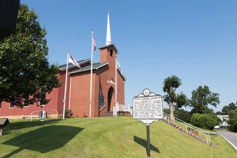
Church completed, 1849. Occupied during the War Between the States by a Federal garrison to protect the one-lane covered bridge, which was a vital link in the James River and Kanawha Turnpike. The soldiers left the Church in shambles. It has been . . . — — Map (db m178194) HM
Site of Camp McDonald, set up, 1862, occupied by the 11th W. Va. Inf., U.S.V. Scene of engagement, May 6, 1862, when Federals under Maj. George C. Trimble beat off an attack by Confederate Moccasin Rangers under Capt. Geo. Downs. — — Map (db m14153) HM
Early in 1862, the 11th West Virginia Infantry in Spencer established an outpost here in Arnoldsburg to suppress Confederate guerilla activity. Union Maj. George C. Trimble commanded four companies here at Camp McDonald, named for former county . . . — — Map (db m73440) HM
One of several partisan groups in
western VA during the Civil War,
the Moccasin Rangers were Southern
sympathizers who operated in the
central counties of present-day West Virginia,
conducting raids and terrorizing
local Unionists. After they . . . — — Map (db m137948) HM
Perry Hays & George Silcott
Peregrine Hays and George Silcott were prominent businessmen before the Civil War. Hays was sheriff of Calhoun County and Silcott county clerk. In 1861, they helped form the Moccasin Rangers. After truce they helped . . . — — Map (db m137949) HM
Born on December 10, 1826, he was
one of the first school teachers
in Nicholas County. He moved to
Clay County before the Civil War
and was a delegate to the first
constitutional convention for West Virginia,
1861-1863. In 1863, he organized . . . — — Map (db m137965) HM
During the Civil War, civilians in West Virginia formed Union militias to combat Confederate guerrillas and to protect the local citizenry. Often called Home Guards, these units were sometimes incorporated into the regular army. There were . . . — — Map (db m179592) HM
Skirmish at West Union
Early on May 5, 1863, six companies of the 2nd WV Infantry under Col. George Latham arrived in West Union to protect area railroad bridges during the Jones-Imboden raid. Two regiments of Confederate cavalry advanced to . . . — — Map (db m142412) HM
Built, 1830, on the old James River and Kanawha Turnpike. Restored antebellum home of Colonel George W. Imboden, on General Lee's staff, C.S.A. Property and headquarters of the Fayette County Historical Society, organized in 1926. — — Map (db m50392) HM
Regular stop on the James River and Kanawha Turnpike. The original building, dating from before the Revolution, was rebuilt by William Tyree, 1810. During the winter of 1861-62, it was headquarters for Chicago Gray Dragoons. — — Map (db m67013) HM
After the Civil War, George W. Imboden lived here with his wife, Mary Tyree, the daughter of William Tyree of Tyree Tavern. When the war began, Imboden enlisted in the Staunton Artillery in Augusta County, Virginia, where he then resided. He . . . — — Map (db m34371) HM
In Westlake Cemetery is the grave of the mother of General Thomas J. "Stonewall" Jackson. The monument at the grave was placed by Captain Thomas Ranson, who had fought in Jackson's old brigade in the War between the States. — — Map (db m34376) HM
During his and Gen. Henry Alexander Wise’s unsuccessful Kanawha Valley campaign, Confederate Gen. John B. Floyd made his headquarters here, August 17-18, 1861, while Wise camped on the top of Big Sewell Mountain. In 1862, according to an inscription . . . — — Map (db m59937) HM
This is one of the earliest identified cemeteries west of the Allegheny Mountains. William Tyree, owner of nearby Tyree Tavern, and Confederate Col. George W. Imboden, brother of Gen. John D. Imboden, are buried here. The cemetery is best known, . . . — — Map (db m173345) HM
During the Civil War, Fort Scammon stood in front of you on the hill behind the courthouse. There, on September 10, 1862, Union Col. Edward Siber and the 1,500 men of his 37th Ohio Infantry defended Fayetteville against Confederate Gen. William . . . — — Map (db m59214) HM
Battle of Fayetteville (1862)
On September 10, 1862, soldiers under the command of Confederate Gen. W.W. Loring attacked Union forces in Fayetteville under Col. Edward Siber, driving them out of the town towards Charleston, where fighting . . . — — Map (db m120516) HM
At the top of the hill here a community came together to help Jewish soldiers
keep their faith in the midst of war. In early April 1862, Pvt. Joseph A. Joel
and 20 other Jewish soldiers in the 23rd Ohio Infantry asked Col.
Rutherford B. Hayes, a . . . — — Map (db m223876) HM
In the attack on Federal forces here, 1863. Milton W. Humphreys, the educator and soldier, gunner of Bryan's Battery, 13th Virginia Light Artillery, C.S.A., first used “indirect firing,” now in universal military use. — — Map (db m55815) HM
Nearby on May 19-20, 1863, Corp. Milton W. Humphreys, gunner in Bryan's Battery, 13th Virginia Light Artillery, C.S.A., made first use of indirect artillery fire in warfare. Target was Union fort in Fayetteville. — — Map (db m217549) HM
John Townsend bought a large tract of land here in 1841, an area that became Lansing, Ames Heights and Canyon Rim Park. Operated a ferry that provided commercial transport across the river at site of present bridge until the civil war. Grandson . . . — — Map (db m78288) HM
When the war began, most residents of this part of present-day West Virginia were Confederate in their sympathies. Both Confederate and Union forces considered the wooden covered bridge here strategically important because the James River and . . . — — Map (db m34373) HM
Christopher Q. Tompkins
Born 1813 in Matthews County, VA.
Tompkins was an 1836 graduate of
West Point. A prominent industrial
businessman in the Kanawha Valley
before the Civil War, from May to
November 1861 he was colonel of
the . . . — — Map (db m138027) HM
Here New and Gauley rivers unite to form Great Kanawha River. Piers still stand of old bridge destroyed by the Confederate troops in 1861. Here Thomas Dunn English, author of the ballad, "Ben Bolt," wrote "Gauley River". — — Map (db m20818) HM
Smoke filled the sky over Gauley Bridge on July 26, 1861, as Confederate Gen. Henry B. Wise's soldiers torched the Kanawha River bridge that stood on the piers directly in front of you. That destruction, however, did not prevent Union Gen. Jacob . . . — — Map (db m242422) HM
Located across Kanawha River from this point was Civil War camp for Union Army, 1862-64. Site had 56 cabins and parade grounds for 23rd Ohio Vol. Inf. commanded by Col. Rutherford B. Hayes and Lt. William McKinley, future United States presidents. — — Map (db m50397) HM
Sandstone formation at 2510 feet is landmark known for view of Sewell Mt. range to SE. Known as "Rock of Eyes" by Native Americans and dubbed "Spy Rock" by Civil War soldiers. Sept. 1861, Gen. J.D. Cox and 5,000 Union soldiers camped here to oppose . . . — — Map (db m34430) HM
Born in slavery in Monroe Co., Sept. 7, 1848, he worked as servant in the Confederate army. Served as teacher and ordained Baptist minister; estab. West Virginia Enterprise, Pioneer, & Mountain Eagle papers; later a lawyer. First . . . — — Map (db m34413) HM
Near here, at highest point on
the Midland Trail, Gen. Robert
E. Lee had headquarters during
his campaign in West Virginia
in 1861. His famous war horse
“Traveler,” was brought to him
here from the Andrew Johnston
farm in . . . — — Map (db m164702) HM
From August to October 1861, about
17,000 Union and Confederate troops
operated near the Sewell Mountain
area. Waiting for a major battle
that never came, many soldiers died
of disease caused by foul weather.
Excessive rainfall hampered . . . — — Map (db m138110) HM
(sidebar)
Confederate Gen. Albert G. Jenkins led 550 cavalrymen on a 500-mile raid from Salt Sulphur Springs, Aug. 22-Sept. 12, 1862, attacking Federal forces and destroying military stores. He captured and paroled 300 Union soldiers, . . . — — Map (db m73427) HM
At the top of the hill is the site of a log fort 30x30 feet in size, built in spring, 1864, for Capt. W.T. Wiant's Gilmer County Home Guards. Occupied until December, 1864. Burned days later by Confederates under Capt. Sida Campbell. — — Map (db m73428) HM
A Confederate company organized at
Glenville in May 1861 by Rev. John
E. Mitchell, the group only had 45
hunting rifles and no uniforms.
Mitchell was replaced by J.S. Kerr
McCutcheon just before the formal
mustering of the company into . . . — — Map (db m174483) HM
On September 18, 1863, a band of
30 Confederate guerillas raided the
town of Troy. They robbed stores
of about $1,000 worth of goods and
pillaged private homes. They also
took captive three residents and
three 6th WV Infantry soldiers. . . . — — Map (db m174486) HM
Cliffs 800 feet high lining great cleft in the New Creek and Knobley mountains, which rival the famed Franconia Notch of New England. Scene of skirmish in 1863 between General Jones' cavalry and Federal troops from New Creek. — — Map (db m36835) HM
On April 20, 1863, Confederate Gens. William E. "Grumble" Jones and John D. Imboden began a raid on the Baltimore and Ohio Railroad from Virginia through present-day West Virginia. Taking separate routes, they later reported that they . . . — — Map (db m165723) HM
On April 20, 1863, Confederate Gens. William E. "Grumble" Jones and John D. Imboden began a raid on the Baltimore and Ohio Railroad from Virginia through present-day West Virginia. Taking separate routes, they later reported that they . . . — — Map (db m178393) HM
Earthworks and other remnants of Union Capt. James A. Jarboe's blockhouse are located nearby, where Jarboe's Co. I, 10th West Virginia Infantry, guarded the Morgantown and Patterson Creek roads intersection. The company also escorted the supply . . . — — Map (db m178391) HM
The strategic importance of Fort Mulligan becomes evident as you observe the surrounding terrain. Roads leading north to New Creek, west to Beverly, Buckhannon and Grafton, south
to Franklin and Staunton and east to Moorefield, Winchester
and . . . — — Map (db m14585) HM
This is one of at least seven known gun positions at Fort Mulligan (note the depression in the angle), which would have dominated the crossroads at Petersburg and its ford on the South Branch of the Potomac River. Confederate General Early . . . — — Map (db m155443) HM
Clearly one of the Fort’s entrances, this “sally port” was probably
needed here to rush men and perhaps cannons out to defend
against an assault up the ravine behind you. This was the only
place a body of hostile infantry could . . . — — Map (db m14577) HM
Union Col. James A. Mulligan, 23rd Illinois Infantry, supervised the construction of Fort Mulligan between August and December 1863. Known locally as Fort Hill, the work protected the South Branch Valley and its Unionist residents and also served . . . — — Map (db m173171) HM
Union Col. James A. Mulligan, 23rd Illinois Infantry, supervised the construction of Fort Mulligan between August and December 1863. Known locally as Fort Hill, the work protected the South Branch Valley and its Unionist residents and also served . . . — — Map (db m173250) HM
Built in 1863 by Union soldiers under Col. James Mulligan on a hill occupied by both Confederates and Federals, the fort protected the vital B&O Railroad to the north and served as a staging area for operations against Confederates. On January 31, . . . — — Map (db m238784) HM
The brick church formerly on this site was named Mount Zion Presbyterian Church. The congregation stopped meeting here after Federal forces occupied Petersburg in May 1862, took over the church building, and began using it as a commissary. The . . . — — Map (db m58681) HM
Patented in 1861 by former Union officer Robert P. Parrott, the Parrott rifle was inexpensive to manufacture and accurate. The Parrott could hit a target at 2,500 yards, about twice the range of a smoothbore gun. They were so accurate that the . . . — — Map (db m163916) HM
Settled about 1745. Near by was Fort George, Indian fort. Federal trenches overlooked the town in 1863 and 1864. Here is grave of Rev. W. N. Scott, pioneer preacher, who built churches at Old Fields, Moorefield, and Petersburg. — — Map (db m162730) HM
As you stand here, near the middle of Fort Mulligan, its sheer size
becomes apparent. It is approximately 700 feet east to west and
400 feet north to south at its widest point. Surrounding you are
the Fort’s intricate inner works called . . . — — Map (db m14529) HM
You are now at the western end of Fort Mulligan. The acute angles at this end of the works were clearly designed to be occupied by several artillery pieces to fend off attacks from the Seneca Road and the ravine to the southwest.
Fort . . . — — Map (db m14536) HM
The Irish Brigade & the McNeill Rangers
General James A. Mulligan, USA
Born June 25, 1830 in Utica, NY, James Adelbert Mulligan was a spirited Irish-American who wore a green scarf in combat. At the outbreak of the Civil War . . . — — Map (db m240181) HM
In December of 1863, Colonel James Mulligan returned to
New Creek and Colonel Joseph Thoburn took command of the
1,785 Union soldiers at Petersburg. Confederate Major General
Fitzhugh Lee’s forces began to move on Petersburg on January 3rd, . . . — — Map (db m14519) HM
During the Civil War, loyal Unionist Home Guard companies patrolled Hardy County (now Grant County) to defend it against Confederate incursions. Near here on Johnson Run on June 19, 1864, a mixed command that included men from several companies . . . — — Map (db m129309) HM
Exploring Fort Mulligan.
A trail system with interpretive exhibits describe the Fort’s construction, usage and strategic importance during the Civil War. Most of the site is wheelchair accessible, however several areas are inaccessible . . . — — Map (db m155441) HM
The Petersburg Gap is a natural wonder exposing Helderberg limestone and Oriskany sandstone cliffs towering more than 800 feet above the South Branch of the Potomac River. The renowned writer and artist, David Hunter Strother whose pen name was . . . — — Map (db m58677) HM
In 1863, your view from here would have been of a barren, muddy landscape, with crude, smoking huts half buried in the hillsides. The area surrounding the Fort was most likely stripped of timber as the need for open fields of fire, fuel and . . . — — Map (db m155444) HM
Buried on hill above eighty-nine unknown Confederate soldiers
from Georgia who perished in camp here during winter
1862 1863 — — Map (db m160845) HM WM
Unknown Soldiers
Six miles west, a Confederate regt. from Georgia camped at Blue Sulphur Springs in improvised shelters, during the winter of 1863. Many died of exposure and disease, and are buried on the hill 400 yards north of the . . . — — Map (db m100004) HM WM
Although saltpeter (potassium nitrate or nitre), an essential element in the manufacture of gunpowder, had been mined at Organ Cave since the eighteenth century, the need for the mineral increased dramatically during the Civil War. Several saltpeter . . . — — Map (db m59342) HM
In November 1863, David S. Creigh, a well-known southern sympathizer, found a Union soldier ransacking his home and harassing his wife. In the ensuing fight, Creigh killed the man, then hid the body. Later arrested, Creigh was tried and, on June 10, . . . — — Map (db m110028) HM
Early in May 1862, Union Col. George Crook, 36th Ohio Infantry, led his command from Charleston to raid the Virginia Central Railroad near Covington. After tearing up track and burning a bridge, he and his men arrived in Lewisburg on May 17, with . . . — — Map (db m59344) HM
The 3rd Provisional Ohio Brigade's camp was on this hill. The Confederate artillery opened the battle at 5 a.m. with a bombardment of the Federal camp. — — Map (db m21739) HM
The 36th Ohio assembled near the courthouse & advanced up Randolph & Chestnut Streets to attack the right of the Confederate line where they routed the 22nd Virginia. — — Map (db m243856) HM
Confederate dead were laid out in the Old Stone Church & then buried in the churchyard without ceremony. After the war their remains were moved to the present Confederate Cemetery. — — Map (db m75375) HM
On the evening of May 1, 1863, Lt. Col. George Edgar moved to block Union troops marching to Lewisburg. Establishing lines at Tuckwiller's hill, Edgar caught the enemy by surprise under cover of darkness early on the 2nd, and reportedly feigned . . . — — Map (db m116378) HM
Remains of 95 unknown Confederate soldiers who fought in the Battle of Lewisburg on 23 May 1862 lie in this cross shaped common grave. It has an upright 80 feet long and cross arms of 40 feet. After the Civil War the unclaimed dead were removed from . . . — — Map (db m21740) HM
In a cross-shaped mass grave at the end of this path lie the remains of 95 unknown Confederate soldiers who fought in the Battle of Lewisburg on 23 May 1862.
This path is the original trace of the James River-Kanawha Turnpike which carried . . . — — Map (db m140681) HM
Side A On the hill, 400 yards west, in a common grave shaped like a cross, lie unclaimed bodies of ninety-five Confederate soldiers, casualties of the area, including those of the Battle of Droop Mountain and the Battle of Lewisburg. . . . — — Map (db m21748) HM
The wartime division of WV lasted into the years just after the Civil War. To protect the new state and political party power, leaders used test oaths to keep ex-Confederates from voting and to limit their role in government. Joseph "Old Scratch" . . . — — Map (db m176398) HM
First established at Lewisburg 1808-09 by Dr. John McElhenney and chartered as an academy in 1812. Used as barracks and hospital during War between the States. Present buildings on north side of town built 1921. — — Map (db m19378) HM
First school was established 1808-09 by Dr. John McElhenney and chartered as an academy in 1812. Used as barracks and hospital during War between the States. The present buildings were erected in 1921. — — Map (db m19382) HM
The remains of 95 unknown Confederate soldiers from the Battle of Lewisburg, fought May 23, 1862, lie in this cross-shaped common grave. It has a vertical length 80 feet long and a cross arm of 40 feet long, with an overall width of 10 feet. . . . — — Map (db m21742) HM
The Battle of Lewisburg was fought on May 23, 1862, between the Southern forces of General Henry A. Heth and the Northern forces of Colonel George Crook, later famous as the captor of Geronimo. The inhabitants of Lewisburg, Virginia, a peaceful town . . . — — Map (db m140701) HM
The Battle of Lewisburg was fought on May 23, 1862, between the Southern forces of General Henry A. Heth and the Northern forces of Colonel George Crook, later famous as the captor of Geronimo. The inhabitants of Lewisburg, Virginia, a peaceful town . . . — — Map (db m203645) HM
Confederate troops under Gen. Henry Heth here, May 23, 1862, were repulsed in attach upon division of Col. Geo. Crook's brigade. The Old Stone Church was used as a hospital. In his retreat, Heth burned bridge over Greenbrier at Caldwell. — — Map (db m19380) HM
Born July 28, 1805, Samuel Price served in the Virginia legislature, 1850-1841 Constitutional Convention, and 1861 Richmond Convention. From 1863 to 1865, he was Lt. Governor of Confederate Virginia. As president of West Virginia’s Constitutional . . . — — Map (db m140698) HM
Nicholas County. Formed in 1818 from Greenbrier, Kanawha and Randolph. Named for Wilson C. Nicholas, governor, Virginia, 1814-1817. In this countý in 1861 sharp engagements were fought at Kessler's Cross Lanes and at Carnifex Ferry. . . . — — Map (db m238104) HM
In this cave, whose beautiful natural formations have long been known, salt petre was manufactured before 1835. When war broke out between the states in 1861, it was a source of powder supply for General Lee's army. — — Map (db m76509) HM
On November 26, 1862, 20 members of Company G, 2nd WV Cavalry, led by Maj. William H. Powell and Lt. Jeremiah Davidson, surprised and routed 500 Confederate soldiers of the 14th VA Cavalry at the base of Cold Knob. Union forces captured more than . . . — — Map (db m144217) HM WM
A two-day encounter, Aug. 26-27, 1863, between Gen. Sam Jones' Confederates and Gen. W. W. Averell's Federals. Action is also known as Howard's Creek, White Sulphur Springs and Rocky Gap. Losses: 350. — — Map (db m76721) HM
Was fought on this site August 26th and 27th 1863. The Confederates, some of Major General Sam Jones' forces were commanded by Colonel George S. Patton and the Federal by Brigadier General William W. Averell. About 4000 troops were engaged. General . . . — — Map (db m76728) HM
Early in 1862, Confederate raids and attacks put Hampshire County and much of the surrounding area under nominal Southern control. The Baltimore and Ohio Railroad and nearby telegraph wires were severed, impeding Federal troop movements. A militia . . . — — Map (db m30455) HM
In 1861, during the early part of the Civil War, Union Gen. Benjamin F. Kelley established Camp Washington here on the Washington Bottom Farm to secure the Baltimore and Ohio Railroad in this area. Located between Romney and Cumberland, Maryland, . . . — — Map (db m81398) HM
On October 24, 1861, Union Gen. Winfield Scott ordered Gen. Benjamin F. Kelley to strengthen his position at New Creek Station (present-day Keyser) on the Baltimore and Ohio Railroad and then march to Romney and occupy the town. Situated on the . . . — — Map (db m81399) HM
Bloomery Iron Furnace
The furnace was built, 1833, by Thomas Pastly and later was owned by Lewis Passmor. He placed a Mr. Cornwell in charge who operated it until 1848 when it was sold to S. A. Pancost. He and his heirs operated it until 1875 . . . — — Map (db m11019) HM
The shop of Jacob Sheetz, a Hampshire County gunsmith, once stood ahead of you in the yard to the right of the house. In 1861, Sheetz found himself unusually busy converting ancient flintlock rifles to the modern percussion type.
The long . . . — — Map (db m58647) HM
Confederate troops under Captain George F. Sheets were defeated by Colonel S. H. Dunning's 5th Ohio Infantry here, Jan. 7, 1862. North River Bridge and a number of buildings were burned by the Federals. — — Map (db m203986) HM
Built by Richard Sloan in 1790. Early stage coach stop and civil war pickett post. Owned by the Sloan family until 1854 and the Parker Family since.
Current owners are fourth generation, David. R. Parker Family — — Map (db m150652) HM
The Union troops at Fort Mill Ridge continued their duties until June 14, 1863. Then, in response to Lee's invasion of Pennsylvania, Campbell's command was ordered to concentrate with the rest of their division at New Creek (Keyser). Confederate . . . — — Map (db m25438) HM
From the protection of the fort and their encampment along Mill Creek, Union soldiers were stationed at picket posts throughout adjacent valleys at key junctions, fords, and approaches. Patrols were sent through the country-side to feel for the . . . — — Map (db m25433) HM
On March 16, 1863, Col. Campbell ordered his command to move their encampment from Romney to the fields adjacent to Mill Creek immediately west of Mill Ridge. Sheltered between the mountain to the west and the ridge, the camp was less vulnerable to . . . — — Map (db m25203) HM
Federal Battery E, 1st (West) Virginia Volunteer Artillery was assigned to the command at Fort Mill Ridge. The Battery was armed with six 3-inch rifled cannons. It is believed that two of these cannons were positioned in the central redoubt. The . . . — — Map (db m25315) HM
In early April, 1863, a Confederate force led by Captain John H. McNeill's Rangers and four additional companies of Virginia cavalry left Rockingham County for West Virginia. At Moorefield, 20 miles south of Fort Mill Ridge, the force divided into . . . — — Map (db m25353) HM
Fort Mill Ridge is a Union fortification constructed between March and June, 1863, to defend the Mechanicsburg Gap and South Branch Potomac Valley. The remains of the fortification have been undisturbed over the past 135 years and are among the most . . . — — Map (db m167998) HM
Constructed in Spring 1863 by the 54th Pennsylvania under Col. Jacob Campbell, the fortifications took advantage of the natural defenses overlooking Mechanicsburg Gap and the South Branch of the Potomac. The site was occupied March-June and . . . — — Map (db m150658) HM
The central redoubt consists of a square earthen platform or rampart, and earthen walls, or parapets. Cuts in the parapets, or embrasures, provided openings through which cannons could fire. The remains of the embrasures can be . . . — — Map (db m25300) HM
The central redoubt house the fort's artillery. The square structure is approximately forty feet wide inside. The fort's entrance was located on the north, its least vulnerable side. Two artillery positions were constructed on each of the other . . . — — Map (db m25244) HM
At the time of the Civil War, the South Branch Valley was comprised of many small, independent farms. The mid-19th century was a golden age of agriculture in the eastern United States, and the valley was among the most agriculturally productive . . . — — Map (db m25186) HM
Around the outside of the central redoubt is the ditch, a significant obstacle attackers would have to climb through to assault the redoubt. At Fort Mill Ridge, the ditch also appears to have been used as a trench from which defending . . . — — Map (db m203672) HM
In late April 1863, the Confederates launched a major raid from Rockingham County into West Virginia. A primary goal of the raid was the destruction of the Cheat River Bridge of the B&O Railroad near the Northwestern Turnpike crossing the Cheat . . . — — Map (db m25436) HM
This is Hickory Grove, the home of Adam and Mary Stump and their son Capt. George W. Stump, who led a company of the 18th Virginia Cavalry during the war. Capt. Stump was always heavily armed with a carbine and numerous revolvers; his men called . . . — — Map (db m174941) HM
The Daughters of Old Hampshire, erect this tribute of affection to her heroic sons, who fell in defence of Southern Rights.
Captains
G.F. Sheetz. •
A. Smith. •
G.W. Stump. •
I.M. Lovett.
Privates
J.D. Adams. •
I.P. Armstrong . . . — — Map (db m159296) WM
881 entries matched your criteria. Entries 101 through 200 are listed above. ⊲ Previous 100 — Next 100 ⊳