On North Elson Street just north of West Washington Street, on the left when traveling south.
On April 27, 1899, at 6:20 p.m. a monstrous killer cyclone approached Kirksville from the southwest taking dead aim on the new Adair County Courthouse. Suddenly, the cyclone veered more to the northeast, making a clear path of destruction from the . . . — — Map (db m144767) HM
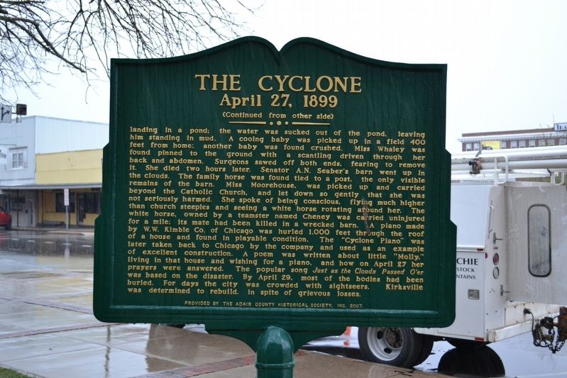
On South 4th Street at Cherry Street, on the right when traveling south on South 4th Street.
During the early stages of Columbia's development, the Smithton Company donated land for a "Market Square" to the Boone County Commissioners. South Fourth Street, known at the time as Water Street, was no doubt created for the traffic of numerous . . . — — Map (db m169424) HM
On South 4th Street at East Broadway, on the right when traveling north on South 4th Street.
June 30, 1909
The depot opens.
November 19, 1976
Depot renovation completed.
Katy Station Restaurant opens for business.
January 29, 1979
Placement on the National Register of Historic Places
May 2, 1979
Formal re dedication of . . . — — Map (db m169445) HM
On South 4th Street at Cherry Street, on the right when traveling south on South 4th Street.
[The marker features images from the MKT's history, as well as a map:]
A 1912 postcard view from East Broadway of the Katy's handsome Columbia passenger station. The impressive depot was built in 1909 and stands today. - Raymond B. . . . — — Map (db m169428) HM
On South 4th Street at Cherry Street, on the right when traveling south on South 4th Street.
During Columbia's formative years, the Flat Branch Creek area served as a crossroads for two important travel routes — the Booneslick Trail and the Providence Plank Road. Beginning in the early 1800s the Booneslick Trail was a passageway for . . . — — Map (db m169427) HM
Katy Trail State Park is one of Missouri's premier attractions, drawing about 400,000 visitors from across the United States and other countries. Stretching 225 miles from St. Charles in the east to Clinton in the west, the trail is the longest . . . — — Map (db m46383) HM
From its inception and throughout its 20-year history, Katy Trail State Park has been one of the most successful rails-to-trail conversions projects in the United States. As the longest developed rail-trail in the United States, it has been . . . — — Map (db m46403) HM
On 10th Street near Seneca Street, on the left when traveling north.
• Built July, 1937 in West Burlington,
Iowa by C.B.&Q. at a cost of $99,285.00
• Weight 288 Tons or 576,000 lbs.
• Class 0-5-B Northern Type
• Used in Passenger and Freight Service
• Later Improvements Totaled $107,525.00
• . . . — — Map (db m47491) HM
On Penn Street at South 10th Street, on the left when traveling east on Penn Street.
John Patee came to St. Joseph in 1845 and opened the city's first drugstore at the corner of of Main and Francis Streets. He purchased 320 acres, platted what was known as "Patee Town" and began selling building lots in 1849. He later built the . . . — — Map (db m22072) HM
On Penn Street near 12th Street, on the right when traveling east.
Between July 4 and October 24, 1861, a telegraph line was constructed by the Western Union Company between St. Joseph, Missouri, and Sacramento, California, thereby completing the first high-speed communications line between the Atlantic and . . . — — Map (db m47465) HM
On Davis Street (State Highway 13) at McGaughy Street, on the left when traveling south on Davis Street.
Hamilton was built around the Hannibal & St. Joseph Railroad, which was completed on Valentine's Day, 1859. In the fall of the same year, the Hamilton Depot was built. In 1885 a spur line to the Hamilton Coal Mine was added and later extended to . . . — — Map (db m156949) HM
On East Main Street just east of North Washington Street (Missouri Highway 13).
The fertile Shoal Creek Valley, Kingston was laid out in 1843 to replace Far West as seat of Caldwell County. Organized in 1836, the county was to be for Latter Day Saints (Mormons), ejected from Jackson County in 1833 and asked to leave Clay . . . — — Map (db m144715) HM
Near Katy Road, 0.9 miles north of Oilwell Road, on the right when traveling north.
1826
Cedar City's Prosperity
The town Hibernia exists in post office records from 1825. A wilder and wider Missouri River was a half mile closer then, and many people arrived by steamboat. While laying out a new town in 1872, David Kenney . . . — — Map (db m169401) HM
On Katy Road, 0.9 miles north of Oilwell Road, on the right when traveling north.
Here at the North Jefferson Trail Head, on Sept. 29, 1996, the east and west sections of the Katy Trail were joined, forging the final link uniting St. Charles and Sedalia via Katy Trail State Park. — — Map (db m169404) HM
On Katy Road, 0.9 miles north of Oilwell Road, on the right when traveling north.
The distance from North Jefferson to Hartsburg is 10.4 miles. The trail passes through Claysville (milepost 149.8) and crosses Turkey, Cedar and Slate creeks. Bluffs are on the right side and a wide variety of habitats including farms and . . . — — Map (db m169399) HM
On Katy Road, 0.9 miles north of Oilwell Road, on the right when traveling north. Reported damaged.
The distance from North Jefferson to Tebbetts is 12 miles. The trail passes through Wainwright (milepost 137.6), which was named after a St. Louis financier who helped establish the Missouri, Kansas & Eastern Railroad, later part of the Katy. . . . — — Map (db m169400) HM
On North Water Street at Themis Street, on the left when traveling south on North Water Street.
Before the coming of the railroad, the Mississippi River was the commercial lifeline of Cape Girardeau. The arrival of the packet boats, loaded with goods for local and regional residents, was an exciting event in the community. To the
left of the . . . — — Map (db m107706) HM
On North Water Street at Themis Street, on the left when traveling south on North Water Street.
After earlier attempts to build a railroad to Cape Girardeau failed, local attorney Louis Houck made an arrangement with creditors to bring a railroad into the city by midnight of January 1,1881. If he could do so, he would acquire clear title to . . . — — Map (db m107752) HM
Near Aquasmi Street, on the right when traveling south.
After the golden age of the steamboat, port cities like Cape Girardeau suffered as railroads provided alternate means of transportation.
Responding to the post-Civil War railroad boom, a syndicated of local business leaders formed the Cape . . . — — Map (db m58672) HM
On East Wall Street, on the left when traveling east.
Midway on Missouri's western border, Cass County was organized in 1835 and named Van Buren. The Free-Soil Party affiliation of Martin Van Buren led to name change, in 1849 for Democrat Lewis Cass. In territory ceded by Osage tribes 1825, the county . . . — — Map (db m20267) HM
The Cass Co. Judges who suffered imprisonment by the U.S. Federal Courts rather than make a tax levy to pay fraudulent Co. and Township Railroad Bonds.
FE Johnston
WP Barnes
Sept 1 1883 to Jan 1 1884
WA Wray
FM George
ET . . . — — Map (db m20268) HM
On 1st Street south of Wyoming Street, on the right when traveling north.
In 1858 John Armstrong purchased this and surrounding land from the U.S. knowing the Pacific Railroad would site its station here. Armstrong sold some land to the railroad for $1.00. By 1865, when the railroad began construction, business men from . . . — — Map (db m88421) HM
On 1st Street north of Commercial Street, on the right when traveling north.
From 1895 to 1913 Rolly Brothers restaurant was here. They had a waiting room for ladies in front and a dining room being cut off by a row of palms. In 1904 the rear half was added facing the Mo. Pacific Depot enabling the restaurant to cater to the . . . — — Map (db m88569) HM
On Boardman Street south of Paul Street / Wyoming Street, on the right when traveling south.
The first depot was of wood frame and built on this site in 1866. It burned in 1901. In 1903 this building was built for the Missouri Pacific R.R. and called the "finest in the state." In 1915 the Wells Fargo office here was robbed. The night man . . . — — Map (db m88338) HM
On Veterans Parkway (AKA Lake Street) at Paul Street, on the right when traveling south on Veterans Parkway (AKA Lake Street).
[Side A]
Pleasant Hill dates back to Missouri's early pioneer days. As early as 1823, there was a trading post located two miles east of the present town that was operated by a French Canadian by the name of Blois.
In 1828, David Creek . . . — — Map (db m88330) HM
Near County Road 81 (County Highway 81) at County Highway CC, on the right when traveling west.
By the 1850s the town had expanded and commercial buildings were being constructed on top of the bluff at Athens. A list of businesses and organizations (circa 1853-1860) reveals the extent of the town's growth.
Wm.B. Armstrong, general store . . . — — Map (db m150597) HM
On South Withers Road, 0.1 miles south of Owens Drive, on the right when traveling south.
This trail follows the original route of the Kansas City, Clay County and St. Joseph railroad through Westboro-Canterbury Park. The "Interurban" provided commuter and freight service to this area beginning January 21, 1913.
Located just . . . — — Map (db m245220) HM
Near Park Lane south of Broadmore Lane, on the right when traveling south.
This portion of the Westboro-Canterbury Greenway Trail originally served as the right-of-way for the Kansas City, Clay County and St. Joseph Railroad. The "Interurban" was a passenger and freight rail system that operated from 1913-1933 on two . . . — — Map (db m245169) HM
On Mill Street (Missouri Route H) at Leonard Street (Missouri Route 33), on the right when traveling east on Mill Street.
An Interurban Train Depot once stood just east of this location. Erected in January 1913 by the Kansas City, Clay County and St. Joseph Railway, the depot served as a terminal for passenger and freight service as part of an electric railway that . . . — — Map (db m68244) HM
On Water Street north of Mill Street, on the left when traveling north.
In 1860 Watkins Mill became the first industry in Clay County. Major industries that followed were Cook Paint and Varnish in 1913, Ralston Purina Company in 1940's and the Claycomo Ford Assembly Plant in 1951. The ASB Bridge was built in 1912 . . . — — Map (db m68311) HM
On North Walnut Street (Business Interstate 35) at East 2nd Street, on the left when traveling south on North Walnut Street.
Abraham Lincoln
1809 - 1865
16th President of the United States
In 1859, the Hannibal & St. Joseph Railroad was the first to cross Missouri. That same year a little-known attorney from Illinois was traveling through Missouri by train. . . . — — Map (db m221274) HM
On U.S. 69 north of 1st Street, on the right when traveling north.
In the 1920's Cameron boasted over 40 trains a day and three active stations, including the elaborate Cameron Junction, described as one of the most popular and elegant eating houses in the West.
Two Cameron men are credited with initiating the . . . — — Map (db m86717) HM
On North Cherry Street north of West 3rd Street, on the right when traveling north.
In 1928, here at the Rock Island Railroad Depot, the Republican nominee for President was in Cameron. Local bridge builder J.C. Dildine and wife Rose, a member of the Republican State Committee, encouraged Hoover make a rear platform talk. But after . . . — — Map (db m221293) HM
On Cherry Street at 3rd Street, on the right when traveling south on Cherry Street.
The memorial tree planted nearby
is dedicated by the Rock Island
in affectionate memory of
John T. Walker
who by his industry courage and
loyalty through every vicissitude
signally aided in the development
of the
Chicago Rock . . . — — Map (db m67375) HM
On Park Avenue, 0.4 miles west of South Chestnut Street, on the right when traveling north.
Rutherford B. Hayes
1822—1893
19th President of the United States
In 1879, things were different when the sitting President Rutherford B. Hayes and his friend General William Tecumseh Sherman stopped at the Junction Depot near Second and . . . — — Map (db m223033) HM
On North Main Street south of East Maple Street, on the right when traveling north.
Once forming part of Missouri's western boundary, Clinton County was organized in 1833 and named for N.Y. Governor DeWitt Clinton. It lost its boundary status in 1837 when the Indian Platte Purchase territory extended the State border to the . . . — — Map (db m198965) HM
On Jefferson Street at Capitol Avenue, on the left when traveling north on Jefferson Street.
Lewis and Clark, 1804
"The object of your mission is to explore the Missouri river, & such principal stream of it, as, by its course & communication with the water of the Pacific ocean may offer the most direct & practicable water . . . — — Map (db m62349) HM
On Buchanan Street just south of West Washington Street (Missouri Highway ZZ), on the right when traveling south.
Ewing's intent was to reach the railroad at Leasburg and take his group by train to safety in St. Louis. But the Confederates rapidly sent detachments east and west of Leasburg to destroy track. In Cuba they burned the depot and several boxcars, as . . . — — Map (db m139828) HM
On North Franklin Street (State Highway 19) at Washington Street (State Highway ZZ) on North Franklin Street.
In 1873 the St Louis, Salem & Little Rock Railroad was completed from Cuba, forty-one miles south, to Salem at a cost of about $1,250,000. It was built to transport iron ore and lead from area mines to market, and later passenger service was added. . . . — — Map (db m58926) HM
On Main Street (Missouri Route 6) at Polk Street (Missouri Highway A), on the right when traveling west on Main Street.
[Side A]
DeKalb County, 270,720 acres of rolling prairie land, is one of 19 Missouri counties organized in February, 1845. The name is for German-born Johann Kalb, member of the French army and general in the American Revolution, known as . . . — — Map (db m88146) HM
Near West Fitzgerald Avenue (U.S. 50) west of West 6th Street, on the left when traveling west.
The Rock Island Railroad was completed through Gerald in March, 1901. In 1902, a depot was built. Destroyed by fire, the present depot was erected to replace it and was operational until March, 1975, when the Rock Island Railroad filed bankruptcy. . . . — — Map (db m132879) HM
Near Main Street west of Miller Street, on the right when traveling west.
Steamboat travel was gaining momentum when Philip Miller saw this tract of land along the Missouri river and felt it would be an ideal wood yard. On June 23, 1836, Miller bought the land and began supplying wood to fuel the steamboats. Soon this . . . — — Map (db m132883) HM
On Main Street at Miller Street, on the left when traveling east on Main Street.
Early prominent Missouri River port, New Haven was settled about 1805 and was first named Miller’s Landing for pioneer Philip Miller.
The Pacific R.R. (MO. PAC.) reached here in 1855 and the town was laid out and renamed the next year.
John . . . — — Map (db m121231) HM
On Main Street west of Cottonwood Street, on the left when traveling east.
With the arrival of the Pacific Railroad in 1855 Miller's Landing became a railroad town. Track was laid westward from St. Louis beginning in 1851. Progress was slow and it was 1865 before St. Louis and Kansas City were connected by rail. The . . . — — Map (db m121293) HM
The City of Pacific, once known as Franklin, takes its name from the railroad that bustles through town. Up to the time of the Civil War only the Pacific Railroad ran from St. Louis to this point.
The main line of the Pacific Railroad was . . . — — Map (db m168408) HM
On West Front Street east of Cedar Street, on the right when traveling west.
The first train arrived in Washington, Missouri, in 1855. That event confirmed Washington's position as the major transportation center in Franklin County. The railroad town's first railroad depot was destroyed in a Civil War raid on October 2, . . . — — Map (db m121238) HM
On West Front Street at Elm Street, on the right when traveling west on West Front Street.
Increased passenger traffic led railroad officials to replace the old frame depot with the new structure located immediately west of the original site. The frame building was rolled to its present site and became the freight depot. — — Map (db m124363) HM
On West Front Street east of Cedar Street, on the right when traveling west.
For several years, Washington's Mayor John J. Ernst, the city council and other officials repeatedly petitioned the Missouri Pacific Railway Company to build a new depot at Washington. Finally, work on the improvement was started early in 1923. . . . — — Map (db m121242) HM
On West Front Street near Elm Street, on the right when traveling east.
C.H. Kahmann had Pacific House built as a tavern and hotel to accommodate passengers on the just-completed Pacific Railroad. Sold to Frederick Wohlgemuth in 1857, it has continued as a tavern under numerous owners. — — Map (db m124362) HM
On West Front Street at Cedar Street, on the right when traveling west on West Front Street.
Washington's first depot was destroyed by fire during a raid by General Sterling Price in 1864. It was originally east of the current brick depot. The present structure is believed to be the oldest surviving frame depot west of the Mississippi River. — — Map (db m124374) HM
On West Front Street east of Cedar Street, on the right when traveling west.
The Pacific Railroad became a reality in Washington in February, 1855. This event allowed Washington to become the largest and most industrialized city in Franklin County. Many changes have occurred since that time within the railroad system. . . . — — Map (db m124372) HM
On East 1st Street (State Highway 100) just east of Gutenberg Street, on the right when traveling west.
The Caboose Museum opened July 4, 2020, to tell the story of the importance of the railroad coming to the Missouri river Valley. Tons like Pacific (formerly Franklin), Washington, New Haven (formerly Miller's Landing), Berger, Herman, Gasconade . . . — — Map (db m169326) HM
On East Mcfadden Avenue just west of North 1st Street, on the right when traveling west.
The "railroad track" pattern was chosen to honor this railroad hotel built in 1910. It now houses the Gasconade County Historical Society Museum. — — Map (db m139786) HM
On U.S. 136/169 at State Route H, on the right when traveling east on U.S. 136/169.
[Front]
Gentry County, first formed in 1841, and fully organized in 1845, is named for Mo. Militia Maj. Gen. Richard Gentry, Colonel of Volunteers in the Florida War, hero of the Battle of Lake Okeechobee, 1837, in which he was killed. A . . . — — Map (db m66516) HM
On East Commercial Street west of North Washington Avenue, on the right when traveling west.
West of this marker 480 feet a construction train of South Pacific Railroad ~~ now St. Louis-San Francisco Railway (Frisco) ~~ pulled into new town of North Springfield at 3 P.M., April 21, 1870. First passenger train, with state and railroad . . . — — Map (db m170811) HM
Near Park Central Square west of E St. Louis Street.
1835 - John Polk Campbell plans Green County seat and donates 50 acres of land for townsite, including 2 acres for Public Square.
1836 - First courthouse, of two story red brick, built in center of square.
1858 - Butterfield Overland . . . — — Map (db m174517) HM
On Main Street (State Highway 6) just north of East 7th Street, on the right when traveling north.
[side 1] Trenton, Settled in 1834, became the seat of Grundy County in 1841, when James S. Lomax gave 80 acres for a townsite. The county is named for Felix Grundy, United States Attorney General 1838-1839. The town name is . . . — — Map (db m179714) HM
On Washington Street at Franklin Street, on the left when traveling south on Washington Street.
[Side A]
Henry County, in the prairie region of west central Missouri, was organized 1834, and named for Va. statesman William C. Rives. It was renamed for Patrick Henry in 1841, after Rives changed from Democrat to Whig. Through the . . . — — Map (db m69513) HM
On West Nodaway Street (Missouri Route 111) just east of South Washington Street, on the right when traveling east.
[side 1] One of 6 counties formed in the Indian Platte Purchase Territory, annexed to the State 1837, Holt County was organized in 1841 and named for State legislator David Rice Holt. The county's 456 square miles, bounded . . . — — Map (db m179434) HM
On 1st Street (State Highway 5/240) at Market Street, on the left when traveling north on 1st Street.
Glasgow, site of first all steel bridge in world, built by Gen. Wm. S. Smith, Engr. 1879 for C. & A.R.R. Replaced 1900 for heavier traffic. Sketch of original bridge above. Glasgow founded 1836. Successor to Old Chariton 1817, Monticello 1829, . . . — — Map (db m217000) HM
On Water Street at Market Street, on the right when traveling south on Water Street.
In 1877, the Chicago & Alton Railroad decided to build a bridge across the Missouri River at Glasgow. It was to be the first large all-steel bridge in the world. Mr. A.F. Hay, of Burlington, Iowa, had developed a steel that met all specifications & . . . — — Map (db m216963) HM
Franklin, 1816
The original town of Franklin, founded in 1816, was located on the north bank of the Missouri River and was the seat of Howard County. It was about two miles southwest of present day New Franklin. The town was named for . . . — — Map (db m46464) HM
On Broadway at Missouri Street (Missouri Route 5), on the right when traveling east on Broadway.
KATY CABOOSE #127 became a landmark in the City of New Franklin on January 3, 1992. The voluntary assistance of dedicated citizens and generous donations of friends across the country made this possible.
CABOOSE #127 was in the service of the . . . — — Map (db m44291) HM
As the first railroad to enter Texas from the North in 1872, the Missouri-Kansas-Texas Railroad Co. was an influential factor in the development of the Great Southwest. Soon after its construction began, the railroad became commonly known as the . . . — — Map (db m46517) HM
On Missouri Street (Missouri Route 5) at Katy Trail State Park, on the left when traveling south on Missouri Street.
The Need
When the Missouri, Kansas and Texas (MKT) Railroad established a division in Franklin, Mo., a switching yard was located south of New Franklin. This switching yard contained seven sets of tracks plus the through line. Missouri . . . — — Map (db m46930) HM
On State Highway 72 at Thompson Road, on the left when traveling west on State Highway 72.
The three towns of Arcadia, Ironton, and Pilot Knob are located in the Arcadia Valley. The valley’s iron mining industry helped spur population growth and led the St. Louis & Iron Mt. Railroad to extend its tracks to Pilot Knob in 1858. The . . . — — Map (db m99143) HM
On S. Main Street at W. Russell Street, on the left when traveling north on S. Main Street.
Settlers to what we now call Iron County arrived in the first few decades of the 19th century. Little did they know what would unfold just a few more decades later when the Civil War erupted in Missouri.
One of those first settlers was Ephraim . . . — — Map (db m99167) HM
On Bogy Street at Walnut Street, on the right when traveling north on Bogy Street.
From 1858 to 1871, Pilot Knob was the terminus of the St. Louis & Iron Mt. Railroad. During the war the supply depot located here supplied Union outposts at Patterson, Centerville, Farmington and Fredericktown. The road to Middlebrook ran alongside . . . — — Map (db m99209) HM
On N. McCune Street, 0.2 miles north of Cedar Street, on the left when traveling north.
The three towns of Arcadia, Ironton, and Pilot Knob are located in the Arcadia Valley. The valley’s iron mining industry helped spur population growth and led the St. Louis & Iron Mt. Railroad to extend its tracks to Pilot Knob in 1858. The . . . — — Map (db m99213) HM
On West College Street at North McCoy Street, on the left when traveling east on West College Street.
The entire country had railroad fever in the 1830s, with the dream that one day a railroad might span the continent! In Independence merchants needed to move goods between the town square and the Wayne City steamboat landing on the Missouri River - . . . — — Map (db m208135) HM
On 39th Street at Gillham Road and Harrison Parkway, on the left when traveling east on 39th Street.
The Pennsylvania Railroad Company presents this statuary to the Kansas City Area Council, Boy Scouts of America, in recognition of Scouting's contribution to this nation and as a lasting tribute to those who have earned its highest award
The . . . — — Map (db m44395) HM
Near East 36th Street at Janssen Place, on the right when traveling east.
Originally platted as part of the City of Westport and intended as a planned, residential area, Janssen Place was conceived and developed by Arthur E. Stilwell, an urban planner and railroad magnate who founded Kansas City Southern and other . . . — — Map (db m194979) HM
On Brookside Boulevard at 55th Street, on the right when traveling north on Brookside Boulevard.
This plaque is placed here in honor of James Gailey Ashley, Jr. and his wife, Pamela C. Ashley, who for 25 years struggled and sacrificed to preserve this railroad right-of-way, which provided freight and passenger service beginning in the . . . — — Map (db m69375) HM
On West 8th Street at Madison Avenue, on the right when traveling west on West 8th Street.
This "Spirit Mall" celebrates the hold, visionary spirit of the Kansas City region in the early days after the Civil War. Even with seemingly insurmountable challenges, the Kansas City community saw opportunity and took the steps necessary to become . . . — — Map (db m199285) HM
On West 8th Street at Madison Avenue, on the right when traveling west on West 8th Street.
In 1803, President Thomas Jefferson doubled the size of the United States with the purchase of 530 million acres of land from the French government. The Louisiana Purchase captured the imagination of our nation with promises of adventure and . . . — — Map (db m199280) HM
By the 1840s, hundreds of steamboats churned up the river carrying settlers west on the first leg of their journey. At Independence and Kansas City, settlers loaded manufactured goods onto wagon trains and headed farther west via the Oregon, . . . — — Map (db m200137) HM
In 1885 board members of The Chicago, Milwaukee, and St. Paul Railroad approved the extension of their line from Ottumwa, Iowa, to Kansas City. The entry of the "Milwaukee Road," as the railroad was later called, into Missouri occurred during its . . . — — Map (db m199582) HM
Built in 1887 for the Chicago, Milwaukee and St. Paul Railroad, the expansive brick building, known in Kansas City as the "Freight House," was originally used as a freight terminal for the historic rail line. The combination freight and office . . . — — Map (db m199579) HM
On West Pershing Road at Main Street, on the right when traveling west on West Pershing Road.
Following the flood of 1903, Kansas City's original Union Depot, located in Kansas City's west bottoms, was rebuilt on this site in 1914 as Union Station and heralded as one of the most beautiful train stations, and the third largest passenger rail . . . — — Map (db m198768) HM
On OK Street west of Main Street, on the left when traveling west.
This 1880s iconic clock was originally constructed by the E. Howard Clock Company. By the mid-1880s it sat at the corner of 10th and Main Streets. In 1918, it was moved to 11th and Grand Avenue. Then in 1936, it was moved to Union Station where, . . . — — Map (db m198747) HM
On Hickman Mills Drive south of Marion Park Drive, on the left when traveling south.
There was once a town here. Holmes Park, with its school, railroad line, houses, and factories, exemplified the western Missouri settlement transition from wagon trails to farming to railroads to communities. At this place, the westward-expanding . . . — — Map (db m245100) HM
On Broadway Boulevard at Westport Road, in the median on Broadway Boulevard.
This map gives a geographic picture of the three trails during the opening of the west from 1845 to 1860. The years note when an area became a territory or was admitted as a state.
The Santa Fe Trail, 770 miles, blazed by William Bicknell in . . . — — Map (db m87320) HM
It was July 3rd, 1869. A crowd of 40,000 elbowed their way onto the banks of the Missouri to celebrate the dedication of a politically empowering marvel – the Hannibal Bridge, the first railroad bridge across the Missouri River. Perhaps more . . . — — Map (db m87460) HM
On SE Main Street north of SE 3rd Street, on the left when traveling north.
This park, named for the founder of the city of Lee's Summit, is located on the original depot grounds which were set aside for railroad use when the town of Strother was platted on October 28, 1865. The town of Strother was later incorporated as . . . — — Map (db m80718) HM
On Esterly Drive, 0.2 miles west of Missouri Route 96, on the right when traveling east.
The beautiful city of Carthage was laid out, 1842, as the seat of Jasper County, organized, 1841, and named for Sgt. William Jasper, Revolutionary hero. Centered in a county of great mineral wealth and good farm land, Carthage grew into a . . . — — Map (db m24311) HM
Prosperity Junction Station
Original site located east
of Carterville
Typical Boarding Station
Serving Communities in the
Four States Mining District
Street Car #60
Electric powered passenger car
circa 1916-1937 . . . — — Map (db m37368) HM
This plaque is dedicated in memory of A. H. Rogers the founder, and the employees of the former S.W. Mo. Elec. Ry. Co., which was headquartered in Webb City, operating over a 94 mile system serving the Tri-State Mining Field from 1889 to 1939. . . . — — Map (db m37365) HM
On Adams Avenue at 3rd Street, on the right when traveling north on Adams Avenue.
Lebanon, lying 1,265 feet above sea level, in Missouri's Central Ozarks, was founded in 1849 as the seat of newly organized Laclede County. Southern settlers named the town for Lebanon, Tenn. The county name honors the founder of St. Louis. When . . . — — Map (db m44872) HM
On SW 6th Street at Gordon Street, on the left when traveling west on SW 6th Street.
Missouri Pacific Caboose, #13645, a gift of the Union Pacific Railway Company, was located in the park on March 10, 1989, a reminder that from May, 1871 to July, 1982 a railroad ran from Lexington to Sedalia through Concordia.
The Lexington and . . . — — Map (db m43989) HM
In March 1872 Harvey Higgins deeded this two block strip of land to the Lexington and St. Louis Railroad stipulating that a depot be built here. The railroad was the first in the county and its depot was the nucleus of Higginsville. In 1880 the . . . — — Map (db m140277) HM
On North Main Street (Missouri Route 11) at West John Street, in the median on North Main Street.
Founded in 1859 and named for John Wood Brooks, who surveyed the town. First incorporated in 1865. The town became division headquarters for the Hannibal and St. Joseph Railroad in 1859. — — Map (db m144456) HM
Near East Park Street at North Main Street (State Highway 11).
In 1859, while laying out plans for Brookfield, John Wood Brooks, surveyor for the Hannibal and St. Joseph Railroad and native of Boston, included a park reminiscent of his hometown Boston Commons. Though it began as one large park, as the town grew . . . — — Map (db m198798) HM
[Front]
Laclede is distinguished as the boyhood home of John Joseph Pershing, Commander of the American Expeditionary Force in Europe during World War I. He was born near Laclede in Linn County, Sept. 13, 1860. At the time, his parents, . . . — — Map (db m67004) HM
On West Broadway Street at Missouri Route 5, on the right when traveling west on West Broadway Street. Reported permanently removed.
The Disney family moved into this home in 1906.
"I went with my family to live in Marceline when I was four years old...I clearly remember the day we arrived there on the train. A Mr. Coffman met us in his wagon and we rode out to our house in . . . — — Map (db m55367) HM
On East California Avenue, on the right when traveling east.
In 1898, the Santa Fe Railway donated land in the center of the city for a park. Walt Disney played in this very park as a child and would later name the first steam engine installed in his Disneyland Resort the E.P. Ripley. As a tribute to our . . . — — Map (db m198822) HM
On Ritchie Avenue east of Main Street, on the left when traveling east.
This locomotive is of the "Consolidation" class, having a wheel arrangement 2-8-0. Santa Fe classified it as 2535 series.
The wheels are of medium size, indicating that it was intended for medium-speed, freight duty.
Number 2546 is one of . . . — — Map (db m67164) HM
On West Broadway Street at North Missouri Avenue (State Highway 5), on the right when traveling west on West Broadway Street.
this home is currently a private residence
"I went with our family to live in Marceline when I was around 4 years old… I clearly remember the day we arrived there on the train. A Mr. Coffman met us in his wagon and we rode out . . . — — Map (db m198821) HM
On Locust Street south of Calhoun Street, on the right when traveling south.
Created from an original painting by Fred Irvin, this scene portrays a pre-World War I Chillicothe setting. The Milwaukee [Road] Depot (demolished in 1977) serves as a backdrop for period vehicles and a drawn streetcar used to transport patrons . . . — — Map (db m67201) HM
312 entries matched your criteria. The first 100 are listed above. Next 100 ⊳