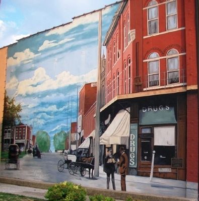
This mural was chosen based on an 1890 postcard of Locust Street in its prime. The street scene depicts the original buildings in downtown Chillicothe with the activity of the day. Many of the buildings illustrated in the murals of Chillicothe are . . . — — Map (db m66736) HM
Chillicothe was a point of convergence for three railroads serving northern Missouri, Burlington, Wabash, and later the Milwaukee Road. This mural includes a scene of a steam engine traveling the local countryside in the last years of the 1890s. . . . — — Map (db m67202) HM
Locomotive No. 112, Mogul Type, 2-6-0, was delivered by Baldwin Locomotive Works, Philadelphia, PA., Nov. 29, 1920, retired from service Dec. 29, 1962. During this period it ran 364,562 miles.
Given to the City of Bevier, January 1, 1963 by J. . . . — — Map (db m116870) HM
The La Plata Square Historic District boundaries include parts of South Gex Street, West Sanders Street, and East Moore Street. These properties are historically associated with services, recreation, and trades bordering and including the City . . . — — Map (db m216982) HM
(side 1) Macon is the seat of justice for one of Missouri's richest coal bearing counties. The town was laid out on rolling upland prairie, between the Middle Fork of the Salt and the East Fork of the Chariton rivers, 1856. Hudson, named for . . . — — Map (db m156228) HM
Maries County, in the central Ozarks of Missouri, was organized in 1855 and named for the Big and Little Maries rivers. The area, in territory ceded by Osage Indians 1808, was roamed by French trappers who early named the Gasconade, Bourbeuse, and . . . — — Map (db m171911) HM
On April 6, 1846 The City of Princeton had its beginning when 22 Lots were sold. It was named for the battle in which General Mercer, the county's namesake, was killed. Samuel Speer owned the site and had a dwelling, a stable and a blacksmith shop. . . . — — Map (db m188198) HM
(Front): Comprising 411 square miles of Missouri's great alluvial plain, this county, organized in 1845, is a high producer of cotton, grain, and soybeans. The Mississippi (Algonquin Indian for Great Water), flowing along some 70 miles of the . . . — — Map (db m17721) HM
Circa 1858, after tracks were laid through California, the Missouri Pacific Railroad built the Central Hotel to house railroad employees. Later, Dr. J.P. Burke, a local doctor who practiced medicine in California for about 50 years, purchased the . . . — — Map (db m62462) HM
From its inception and throughout its 25-year history, Katy Trail State Park
has been one of the most successful rails-to-trails conversions projects in the
United States. As the longest developed rail-trail in the United States, it
has been . . . — — Map (db m162217) HM
The McKittrick-Portland segment is 15.10 miles long.
After leaving McKittrick, the trail goes under Highway 19 and crosses the Loutre River. Hermann is visible across the river valley from around milepost 102. Deutschheim State Historic Site . . . — — Map (db m162215) HM
Katy Trail State Park users cover the longest
segment between trailheads on the entire trail from
McKittrick to Treloar: 16.10 miles. McKittrick is a former
Katy Railroad town, and remains of the depot foundation
and coal sheds are still . . . — — Map (db m162216) HM
Morgan County, in Missouri's Lake of the Ozarks Region, was organized in 1833 and named for Revolutionary War Gen. Daniel Morgan. The lake, impounded by Bagnell Dam built on the Osage River in adjacent Miller County 1929-1931, extends into Morgan . . . — — Map (db m140835) HM
[side 1] Here in the extreme southern Missouri Ozarks, Oregon County was organized in 1845, and named for the Oregon Territory of the Far West. One of 11 counties along the Arkansas border, Oregon is in a region long roamed . . . — — Map (db m179894) HM
[side 1] Named for the river on its west border, Osage County was organized, 1841. A seat of justice was centrally located the next year and named Linnville, later Linn, for Lewis F. Linn, Missouri's "Model Senator." J.W. Robinson gave land . . . — — Map (db m180900) HM
(Front): The capital of historic Pemiscot County and center for a cotton, grain, timber, and industrial area, Caruthersville was laid out, 1857, by George W. Bushey and J. Hardeman Walker (1794-1860), on the Walker plantation. "Bootheel" . . . — — Map (db m36219) HM
1860...
Vision of Prosperity
Welcome to Sedalia, Pettis County seat and home of the Missouri State Fair. Sedalia, originally named Sedville, began as a vision in the mind and on the farm of George R. Smith. "Sed" was the nickname of . . . — — Map (db m85305) HM
The Katy Depot signifies the importance of Sedalia in the history and development of the Missouri, Kansas and Texas Railroad as well as the railroad's importance to the history and development of Sedalia.
Listed on the National Register of . . . — — Map (db m85225) HM
From its inception and throughout its 25-year history, Katy Trail State Park has been one of the most successful rails-to-trail conversions projects in the United States. As the longest developed rail-trail in the United States, it has been . . . — — Map (db m85301) HM
Presented to the MO State Fair by Frisco Railway. Accepted by Gov. James T. Blair Jr. Aug. 20, 1956. Moved from Ft. Scott, Kan. to its present location by the MKT. Railroad.
Original cost: $194,845
Built by Baldwin Locomotive Works
Aug. 1943 . . . — — Map (db m85023) HM
The Sedalia Depot visitor center is the place to begin a Sedalia sightseeing tour. Building hours are posted on the door, and visitors are welcome to tour the historic building, discover the history of Sedalia's railroad culture and learn . . . — — Map (db m85311) HM
Clifton City, the next trail head east, is 11.7 miles by way of the old rail corridor. Due to an undeveloped section of trail immediately east of here, some travel over city streets is required, adding slightly to that distance. The grade is . . . — — Map (db m85314) HM
Green Ridge, the next trail head west, is 12.1 miles from here. The grade between these two trail heads remains fairly level, with a slight decline beyond the Missouri State Fair. The grade increases past Campbell Siding and decreases again to . . . — — Map (db m85315) HM
The Railroad is a mighty force
magical and mysterious
Trains represent noise, rhythm and change.
To many trains seem a thing of the past -
the stuff of story books.
With this art piece the
Sedalia Heritage Foundation
sought to provide . . . — — Map (db m85228) HM
This is an original French boxcar. The 40 Homme et 8 Chevaux painted on the ends means this car holds 40 men and 8 horses (or mules). The plaques represent the French provinces. American troops rode these boxcars to and from battle in WWI and . . . — — Map (db m85073) HM WM
The Trail's End Project is an historical, educational and artistic tribute to the American spirit of opportunity, adventure and perseverance staged in the 1860's era of dynamic western development. The times were turbulent with political[,] . . . — — Map (db m85134) HM
This passenger car was built in 1883 by the Barney & Smith Car Company from Dayton, Ohio. The Barney & Smith Company built premier railroad passenger cars from 1848 to about 1894 and electric trolley cars for the next 20 years. The company had . . . — — Map (db m157186) HM
In 1953, communities began asking Frisco Railroad [sic - Railway] to make the old Frisco steam locomotives available as historic attractions for cities located along the old Frisco line. Dr. Clair V. Mann, secretary/historian of the Phelps County . . . — — Map (db m157163) HM
Steam locomotive 1501 was once part of a proud stable of thirty such engines on the Frisco Railway system. Built in 1923, the handsome modern machine was the pride of the fleet until dieselization of the system in the late 1940s. The 1501 was part . . . — — Map (db m157161) HM
Site of hand-hewn log structure built in 1855 as contractors office for southwest branch of Pacific Railroad Later served as home of Edmund Ward Bishop — Founder of Rolla During Civil War was used as officers quarters As the Eagle Hotel it was . . . — — Map (db m186159) HM
"The automobile age in Rolla began about 1905." "The city began paving streets with brick in 1908, filling rutted paths and deep holes on Eighth and Pine streets...". "Local support for better roads coincided with national and regional promotions. . . . — — Map (db m139754) HM
The Pandemic of 2020
In January of 2020, a coronavirus made it from China to the United States and by mid-March had spread across the entire world. Named COVID-19, it was considered so deadly that the government forced many businesses to . . . — — Map (db m157177) HM
Here in Kansas City, hikers and bikers can get a large dose of history with their fitness routines, thanks to the location of the city’s top trails.
One of the most popular city trails follows an old trolley line that once carried riders from . . . — — Map (db m43189) HM
If you wanted a steak in New York before 1867, you pretty much had to wait until your dinner came in on four legs from Texas to the railheads in central Missouri, and finally hitched a train to Chicago. It was there that cattle were unceremoniously . . . — — Map (db m43199) HM
Railroads and cattle. The two were made for each other, and nowhere did that become more evident than right here in Kansas City.
As cattlemen began using the expanding Kansas Pacific railroad to move cattle more quickly from Texas to points . . . — — Map (db m43184) HM
[side 1] Judicial seat of Putnam County since 1853, Unionville lies 1070 feet above sea level in a scenic region of wooded hills and rolling prairies. Unionville, first named Harmony, was the fifth site to be designated county . . . — — Map (db m179724) HM
Moberly, the “Magic City,” grew from the town platted by the North Missouri R.R. (Wabash) in 1866 to a transportation center with a 6,070 population by 1880. The North Mo. acquired the site when it took over the Chariton and Randolph R.R. after . . . — — Map (db m110128) HM
Named for Governor C.H. Hardin, incorporated in 1870 with James Darby the first mayor. Located on the Santa Fe and Wabash railroads in rich Missouri River bottom land.
The John Vanderpool family came from Tennessee in 1815 and settled at Buffalo . . . — — Map (db m198478) HM
[side 1] In an area of rugged beauty near the geologic center of the Ozark Highland, Reynolds County was organized 1845, and named for Missouri's 7th governor, Thomas Reynolds. Drained by the Black River, called L'eau Noire by . . . — — Map (db m179937) HM
The second county formed in Missouri's famed Southeast Lowland Region, Scott was organized 1821, and named for John Scott, the State's first Congressman. Southerners were first settlers on Spanish land grants in the late 1790's. The King's Highway . . . — — Map (db m161191) HM
Bethel, in North River Valley, five miles from Shelbyville, was founded in 1844 as a religious communal colony by Wilhelm Keil and his German-American followers. Keil (1812-1877), an independent preacher, called his adherents "Christians." . . . — — Map (db m149765) HM
From Augusta to Dutzow along Katy Trail State Park is 7.70 miles. Augusta has a strong German heritage like many other lower Missouri River towns. This area has several wineries open to the public. Founded in 1836, Augusta has preserved . . . — — Map (db m133204) HM
Around the time of the Civil War, southwestern St. Charles County was a rural and isolated community. By 1888, the Missouri-Kansas-Texas Railroad negotiated to extend its line through the region. As the railroad moved in, two towns sprung up . . . — — Map (db m133233) HM
Welcome to Katy Trail State Park, one of 87 state parks and historic sites managed by Missouri State Parks. Whether you are beginning or ending your journey, Machens is the eastern terminus of the park. From this point, the Katy Trail . . . — — Map (db m169575) HM
1830 - Part of Nathan Boone's survey of the Commons.
1835 - Part of Andrew Wilson's 999 year lease of the Commons ground.
1876 - Census of St. CHarles Township lists the family of Henry Kroetter (farmer) and wife Catharine and six . . . — — Map (db m133264) HM
From its inception and throughout its 25-year history, Katy Trail State Park has been one of the most successful rails-to-trails conversions projects in the United States. As the longest developed rail-trail in the United States, it has been . . . — — Map (db m163853) HM
The railroad brought touring companies including vaudeville shows, to the opera houses of America. The 1902 production of Uncle Tom's Cabin required two sixty-five foot special cars for the lavish sets and costumes. Tickets were twenty-five, . . . — — Map (db m124874) HM
Many hotels opened and closed in St. Charles during the railroad boom of the 1870s and 1880s. the Galt Hotel and saloon survived the railroad boom, Prohibition, the Great Depression, a tornado, and a runaway railroad car. — — Map (db m124880) HM
In 1830, still in the afterglow of the Louisiana Purchase, Nathan Boone was contracted to survey the lands of Missouri that would be recognized as St. Charles. By 1835, this plot resided within Andrew Wilson's subdivision. The first person . . . — — Map (db m133258) HM
Rolling Along the Katy Trail
• The Missouri-Kansas-Texas (MKT) railroad rolled along this route from 1870 to 1988. Locomotives of every era traveled here, tracing the path of the Missouri River, from the early, wood-burning steam engines, . . . — — Map (db m150851) HM
1830 - Part of Nathan Boone's survey of the Commons.
1837 - Part of Andrew Wilson's 999 years lease of the Common ground.
1870 - Lot number 6 of Boone's survey block 9 was subdivided between R. B. Fraysier and A. H. Edwards. . . . — — Map (db m133261) HM
The distance from Greens Bottom to St. Charles is 6.20 miles. Traveling east toward St. Charles, the elevation remains almost constant. Greens Bottom (milepost 45.7) is named for the American Revolutionary War (1775-1783) veteran James Green, . . . — — Map (db m169568) HM
The distance from Greens Bottom to Weldon Spring is 10.30 miles. Trail users heading west pass between bluffs and bottomland farm fields in this wide, flat inside bend of the Missouri River. Between milepost 49 and the Weldon Spring . . . — — Map (db m169567) HM
North 2nd Street Shops
North Second Street was a bustling thriving commercial district. Butchers, bakers, tinsmiths and saddle makers all had shops on the street; many lived above them on the second floor. Farmers brought their grain to the . . . — — Map (db m150983) HM
1769
Les Petites Côtes, River Gateway
St. Charles stands on the banks of the Missouri River as the gateway to the Missouri River valley. First known as Les Petites Côtes (Little Hills), it was founded by Louis Blanchette in 1769 as a . . . — — Map (db m169194) HM
Picturesque St. Charles hugs the banks of the Missouri River. The mixture of French, early American and German influences and careful restoration to make this a unique historical town.
Main Street of St. Charles was recognized as a . . . — — Map (db m169202) HM
Via the Katy Trail, St. Charles to Machens is 12.6 miles. As you head east, the Missouri River emerges from its bluff-shrouded valley into the expansive bottomland of the Illinois-Missouri-Mississippi rivers. The bluffs around St. Charles . . . — — Map (db m169208) HM
The distance from Weldon Spring to Greens Bottom is 10.30 miles. From the trailhead, Katy Trail State Park runs through the 8,000-acre Weldon Spring Conservation area for five miles until milepost 51.2. Besides providing a scenic background . . . — — Map (db m169486) HM
From Weldon Spring to Matson is 4.60 miles, one of the shortest distances between trailheads in Katy Trail State Park. At milepost 56.7, less than a mile from the Weldon Spring trailhead is a junction with the Hamburg Trail, a converted haul . . . — — Map (db m169484) HM
In 1855, William M. Allen donated land to establish a new community in St. Charles County. Allen laid-out the town, which consisted of a narrow tract of ground seven blocks long, lying east and west, and established a train station to serve the . . . — — Map (db m169519) HM
Before Appleton City was founded, the open prairie was the hunting grounds for the Osage Indians and French fur traders and trappers.
When the Missouri Kansas and Texas Railroad reached this site in September 10, 1870, where was no town. The . . . — — Map (db m181431) HM
Missouri, Kansas & Texas Railway arrived in 1870 connecting St. Louis to the Southwest
Oldest M.K.&T Passenger Depot, September 1870 — — Map (db m88737) HM
The proposed site for Forest Park was a 40-minute carriage ride from downtown. To overcome public fears about the land's remote location, park planners guaranteed to make it accessible via inexpensive rail service. — — Map (db m133317) HM
Underneath your feet here at Seventh Street, MetroLink winds its way through a railroad tunnel in use since 1875. This double-arched, two-track tunnel was built for freight and passenger train travel from Eads Bridge to the rail yards south of . . . — — Map (db m141183) HM
Two days after being involved in a terrible train crash, in which Cardinals players had served as rescuers, the team beat the Boston Braves 8-6 to climb within two games of first place. — — Map (db m133443) HM
In March 1861, William Tecumseh Sherman became president of a local railroad based here at Locust and Broadway.
However, upon the outbreak of the Civil Way in April 1961, Sherman quit the railroad to be a leading general in the Union army. . . . — — Map (db m236903) HM
The trainshed above you was built using Pegram trusses, which are most frequently seen in bridge construction. This truss style was patented by engineer George H. Pegram, a graduate of St. Louis' Washington University. — — Map (db m219052) HM
America's first seam locomotive lost its first race to a horse-drawn carriage. Credit: U. S. Department of Transportation Federal Highway Administration. — — Map (db m219056) HM
This building was constructed in 1907 as a haven for traveling railroad workers. We are proud to have restored this historic structure and will continue the long standing tradition of providing rooms for the traveler. We wish you a pleasant stay. — — Map (db m144599) HM
has been designated a
National
Historic Landmark
This site possesses national
significance in commemorating
the history of the
United States of America
———————
[Markers on interior . . . — — Map (db m62210) HM
In the days before automobiles, St. Louisans depended on streetcars. The first streetcar line reached Forest Park in 1885. Within a decade, the park was drawing more than 2.5 million visitors per year. — — Map (db m139720) HM
Since the 1904 World's Fair in St. Louis, Forest Park has been a St. Louis treasure and top tourist destination. Known as the crown jewel of the Midwest, 13 million people visit the the 1,300-acre park each year. The park includes 170 acres of . . . — — Map (db m133309) HM
You're en route to a Forest Park icon — the Dennis & Judith Jones Visitor and Education Center, operated by Forest Park Forever in partnership with Explore St. Louis.
Originally built in 1892 as the Lindell Pavilion Streetcar shelter, . . . — — Map (db m139718) HM
Lindell Railway Company opened the Lindell Pavilion as a shelter for visitors who took the streetcar to Forest Park for a day's relaxation away from the city. The building was remodelled in 1914 as a golf and tennis locker room and pro shop. . . . — — Map (db m226791) HM
This home was built when the Central Pacific Railroad was laying tracks across the mountains and valleys from the West and the Union Pacific Railroad was laying tracks coming from the east to build the transcontinental railroad. The home was one . . . — — Map (db m133194) HM
Before construction of Interstate 55 and of some of the large industries along the river, DeMenil Place offered an expansive view of the Mississippi River.
The Mississippi was the original interstate of the Midwest, cutting through otherwise . . . — — Map (db m133185) HM
The Iron Mountain Railroad's tracks were laid in 1855. It traveled to St. Louis to Carondelet 10 times per day, spurring a great deal of industry in the community. — — Map (db m139712) HM
This station serves as a connector on the Loop Trolley system, taking passengers directly over the MetroLink light rail system. Here at Forest Park and DeBaliviere, visitors can connect to both the Red and Blue Line trains, traveling as far east as . . . — — Map (db m141949) HM
Called the "knuckle" of the Loop Trolley system, the intersection of Delmar & DeBaliviere is a crucial connector to the neighborhoods and businesses to the community today. This area and others along the 2.2 mile route are the focus of transit . . . — — Map (db m141910) HM
The 1928 Wabash Station was once served by the "Delmar" and "City Limits" streetcar lines, buses, and the Wabash railroad's intercity and commuter trains. When St. Louis decommissioned its Delmar streetcar #10 in 1964, service ended on what is . . . — — Map (db m144364) HM
Beginnings
Prior to European settlement, what is recognized today as St. Louis was home to various Native American people: first a large Mississippian community numbering in the thousands, and later groups that moved in and out of the area . . . — — Map (db m169046) HM
Settlement in St. Louis County first occurred along the three main thoroughfares out from the city: Gravois to the southwest, Manchester to the west, and Natural Bridge to the northwest. Railroad development paralleled the Mississippi River to the . . . — — Map (db m124998) HM
One of the two experimental demonstrator "Aerotrains" (#2 and #3) built by GM with a new light weigh construction and low center of gravity concept, powered by 1,200 h.p. futuristic locomotives. Initially in mainline service, they rode poorly at . . . — — Map (db m133024) HM
In 1901 at this site along Spot Drive, a loop was built becoming the end of the Ferguson streetcar line. In 1907, Ferguson joined Kirkwood making the longest streetcar line in St. Louis County. Streetcar service was enjoyed for half a century before . . . — — Map (db m238836) HM
Elected twenty-seven times to the office of Mayor he served from 1865 to 1890 and then again from 1892 to 1893, dying in office. He helped to bring the West End Narrow Gauge Railroad to Florissant and under his leadership Florissant offered land and . . . — — Map (db m145367) HM
Narrow Gauge Railroad Station 1878
has been placed on the National Register of Historic Places by the United States Department of the Interior — — Map (db m233584) HM
In 1852 this land was obtained from Owen Collins by the Pacific Railroad for a right of way and in 1863 a frame depot was built. Here members of the first school board met to draft the charter of the Kirkwood School District which was granted on . . . — — Map (db m140848) HM
James Pugh Kirkwood was born in Edinburgh, Scotland. He came to the United States in 1832 and was appointed Resident Engineer for the Western Railway of Massachusetts, and later the Long Island Railroad. He won recognition for the rapid . . . — — Map (db m140854) HM
2-2-2 Type inspection locomotive built by Baldwin Locomotive Works. The "Black Diamond" has a walnut paneled observation room, seats eight, is 22'9 1/4" long weighs 26,300 lbs, and is believed to be the the last steam inspection locomotive in . . . — — Map (db m156296) HM
This 4-4-0 "American" type locomotive was designed by Master Mechanic George S. Griggs and built by the railroad's shops. It is the only surviving "Dutch Wagon," locomotive, with its cylinders under the smokebox and inside the frames, a popular . . . — — Map (db m132981) HM
The Whitcomb Locomotive Company of Rochelle, Illinois built this 15 ton, model SRD industrial switching locomotive. It was a gasoline-mechanical engine, but it was later given an 87 HP, 3-cylinder, GM diesel engine. It has a clutch and manual . . . — — Map (db m132940) HM
This wooden "combine" car carries both coach passengers and baggage. It is typical of many cars of the era, and was used for Boston area commuter service after steel cars became common. Its body is 60' 6" long, and its overall length is 67' 6." It . . . — — Map (db m132984) HM
Built by the Electro-Motive Division of GM as part of "the diesel that did it", the four unit demonstrator locomotive that proved the efficiency of diesel power compared to steam. Number 103 is a 16 cylinder, 567 series engine rated at 1350 h.p. . . . — — Map (db m133014) HM
In this car the small sliding door above the side entry door was used for the milk loading hose. To keep the interior as clean as possible during loading the entry doors were kept closed once this piping was hooked up unless a worker was going in . . . — — Map (db m132941) HM
This caboose was built by the Northern Pacific Railway at their Brainerd, MN shops. The cupola on top is a lookout for its crew, where they can keep watch on the freight cars as the train runs. It was rebuilt in 1968 with a propane-fired heater . . . — — Map (db m132935) HM
Built by ALCO-GE for use on electrified track between Grand Central station in New York City and Harmon, N.Y. Number 113 is a 2+D+2 Class S-2 which was the prototype for thousands of Lionel and Ives electric trains. Donated in 1963 by the New York . . . — — Map (db m132947) HM
Built by Davenport Besler Corp., the #1149 is a 1-B-1 experimental gas-turbine locomotive which has two Boeing 502-2E, 150 h.p. jet engine type gas turbine and was tested by the Army at Fort Eustis, VA. Donated in 1980 by its designer R. Tom Sawyer. — — Map (db m132939) HM
The jewett car Company of Newark, OH, built the "convertible," double-ended elevated car with removable window panels as of an order for 100 cars. They operated as open sided cars with safety bars across the window openings during warm weather. This . . . — — Map (db m132957) HM
312 entries matched your criteria. Entries 101 through 200 are listed above. ⊲ Previous 100 — Next 100 ⊳