On F Street at 6th Street, on the right when traveling south on F Street.
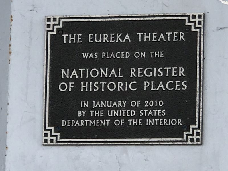
Streamline Moderne Architecture
Built for George Mann; William B. David,
architect; striking neon blade sign,
curved-edge canopy, and Moderne interior
Eureka Historic Landmark — — Map (db m176787) HM
On 2nd Street west of E Street, on the right when traveling west.
Romano Gabriel spent nearly three decades making the hundreds of brilliant objects filling the front yard of his Eureka home. Gabriel fashioned his brightly painted trees and flowers out of vegetable crates, adding droll faces and figures. Some of . . . — — Map (db m176791) HM
On Country Club Drive, 0.3 miles south of California Route 115, on the right when traveling south.
Harold Bell Wright rose from poverty to become "America's favorite author" for the first three decades of the 20th Century.
Many of his 19 books were best sellers and made into both "silent" and later "talkies". They include '"The Winning of . . . — — Map (db m62033) HM
On Country Club Drive, 0.3 miles south of California Route 115 when traveling south.
Prolific author Harold Bell Wright purchased 160 acres here in 1907. While living in a tent he built Rancho El Tecolote, constructing a woven arrow weed studio in 1908 and a ranch house in 1909. From 1907 to 1916 he wrote three best sellers, . . . — — Map (db m62032) HM
Bert Vaughn of Jacumba built the stone tower in 1922-23 to commemorate the pioneers and road and railroad builders who opened the area. In the 1930s W.T. Ratcliffe carved the stone animal figures which lurk in the rocks surrounding the tower, . . . — — Map (db m149171) HM
Near Beal Road near Telephone Road, on the right when traveling north.
Salvation Mountain is Leonard Knight's tribute to God and His gift to the world. Leonard came to Slab City in 1984. Over the following 28 years, he devoted himself to the creation of Salvation Mountain. This folk art monument is Leonard's way of . . . — — Map (db m114547) HM
On Beal Road near Telephone Road, on the right when traveling north.
This is the culmination of a personal religious intensity few mortals will ever experience. Started as a temporary monument to God's love in 1984 by Leonard Knight, it grew into the worldwide phenomenon you see before you.
Born on November 1, . . . — — Map (db m114541) HM
Near Kumeyaay Highway (Interstate 8) 3 miles west of Forester Road (County Road S30), on the right when traveling east.
"California is one of the richest repositories of Native American rock art in North America.
Rock art - is an inclusive term for symbols created on natural rock surface.
pictograph - painted rock art.
petroglyph - . . . — — Map (db m205837) HM
On California Route 190, 0.2 miles east of Emigrant Canyon Road, on the right when traveling east.
Among the first structures greeting visitors entering
the park from the west, these two stone buildings at
Emigrant were built to serve as a ranger station and
are a legacy of the Civilian Conservation Corps
(CCC). Created by President Franklin . . . — — Map (db m159295) HM
On Titus Canyon Road, 18 miles west of Highway 374, on the right when traveling west.
Indian rock carvings are found throughout
the Western Hemisphere. Indians living today
deny any knowledge of their meaning. Are they
family symbols, doodlings, or ceremonial
markings? Your guess is as good as any.
Ancient Archives . . . — — Map (db m159528) HM
On Market Street at Webster Street, on the right when traveling west on Market Street.
“But if ever you come beyond the borders as far as the town that lies in a hill dimple at the foot of Kearsarge, never leave it until you have knocked on the door of the brown house under the willow-tree at the end of the village street, and there . . . — — Map (db m2955) HM
On South Main Street, on the right when traveling south.
This Plaque Presented to The Beverly and Jim Rogers Lone Pine Film Museum to Honor Masons and Shriners.
Dedicated to all Masons and Shriners who appeared in movies filmed in the Alabama Hills, Lone Pine and surrounding areas. Presented by Kerak . . . — — Map (db m72578) HM
On South Main Street (U.S. 395) just south of Post Street, on the left when traveling south.
The story of movie-making in Lone Pine must include local rancher Russell Spainhower, who for years was Hollywood’s main contact man here. “We need 50 horses and 10 wagons next week,” they’d say and Spainhower would arrange it, plus help . . . — — Map (db m146399) HM
On Whitney Portal Road at Movie Road, on the left when traveling east on Whitney Portal Road.
Since 1920, hundreds of movies and TV episodes, including Gunga Din, How The West Was Won, Khyber Rifles, Bengal Lancers, and High Sierra, along with, The Lone Ranger and Bonanza, with such stars as Tom Mix, Hopalong Cassidy, Roy Rogers, Gary . . . — — Map (db m52103) HM
On Main Street (U.S. 395) just south of Post Street, on the left when traveling south.
The Dow Hotel was built in 1923 to accommodate the growing numbers of movie companies coming regularly to Lone Pine even then. The motel units were added in 1957. Those who stayed here over the years while filming in the Alabama Hills include Tom . . . — — Map (db m146400) HM
This District possesses national significance in commemorating the history of the United States Of America.
The Coso Rock Art District contains the largest concentration of unaltered prehistoric petroglyphs and associated sites in North . . . — — Map (db m196327) HM
The first thing I remember knowing was a lonesome whistle blowing
And a youngun's dream of growing up to ride
On a freight train leaving town not knowing where I'm bound
And no one could change my mind but Mama tried
-From Mama Tried, . . . — — Map (db m136236) HM
On Chester Avenue at Beardsley Avenue, on the right when traveling north on Chester Avenue.
This mural depicts Oildale around 1899, from the bridge to the surrounding oil derricks on the hills.
Oildale was called "Waits" during the oil boom.
To your right is Waits Train Station, on Norris Road.
Several business sprang up, . . . — — Map (db m64663) HM
On 20th Street at H Street, on the right when traveling west on 20th Street.
The Fox Theater was designed by Los Angeles-based motion picture theater architect S. Charles Lee (1899-1990), built by Beller Construction, and supervised by local architect Charles H. Biggar (1882-1946). The three-story Spanish Colonial Revival . . . — — Map (db m115126) HM
A fifth generation native of Kern River Valley, Bob is best remembered for the 9 history books he wrote. Without him much of what happened in our valley’s past would have been lost. He was a cowboy, cattleman, ranger, family man and historian. But . . . — — Map (db m25238) HM
James Dean made his last stop at this corner on Sept. 30th, 1955. The young actor died in a car crash a short time later while enroute to Salinas for an auto race. Althouh he appeared in only 3 films, James Dean remains a legend. — — Map (db m228036) HM
On Jawbone Canyon Road at Aerospace Highway (California Highway 14), on the right when traveling north on Jawbone Canyon Road.
"Josie" was born on June 18, 1875 in Silver City, New Mexico to Harvey and Harriet Whitehall. At 19 years old, she taught school in Pinos Altos, New Mexico. She married Herbert Hall Bishop on March 4, 1896, bearing him seven children. The Bishops . . . — — Map (db m78560) HM
The Commercial Hotel
The mining boom of 1922 created a demand for more hotels. To help fill this demand Mrs. Artibe had the Commercial Hotel built in 1922. The lumber for this hotel was finished by the Johannesburg Lumber Company.
My Place . . . — — Map (db m196347) HM
A street dance held in 1915 commemorated the first electric streetlights installed in Tehachapi. The site of the dance was the corner of Green and F Street. The building there housed the Masonic Lodge and Post Office in 1915, and the mural shows the . . . — — Map (db m53119) HM
On Green Street, on the left when traveling south.
Originally opened in 1936, the Beekay Theatre survived the historic earthquake of 1952 and endured a number of façade changes before burning in the 1990’s. The reconstruction preserves the original façade behind, which lies a fully modern theatre. . . . — — Map (db m52969) HM
On F Street at Green Street, on the left when traveling west on F Street.
In this village scene from before contact with the white man, women weave baskets and grind foodstuffs in bedrock mortars. Children play games, as the men make tools and weave rabbit pelt blankets. The border shows more recent members and elders of . . . — — Map (db m140486) HM
On South Curry Street, on the right when traveling east.
The original Red Front Blacksmith Shop was located directly across the street from this mural. The workers pictured represent many local ranching families. The images in the ovals next to the buildings show scenes from Tehachapi's ranching history. . . . — — Map (db m53116) HM
On Pauley Street at Tehachapi Boulevard, on the right when traveling north on Pauley Street.
The Tehchapi Loop put Tehachapi on the map when it was completed in 1876. Before that time there was no rail access across the Tehachapi Mountains. The historic Loop is pictured here, circa 1952, with a trompe l'oeil effect showing damage to the . . . — — Map (db m53117) HM
On East F Street, on the right when traveling east.
Avelino Martinez was of Mexican, Indian and Chinese descent, four feet-four inches tall and thirteen years of age when he came with a group of drovers to the United States from Sonora, Mexico, searching for his father. He worked as a groom for . . . — — Map (db m52918) HM
This redwood paneled craftsman style building was constructed in 1916. The architect was no less than the nephew of Henry Wordsworth Longfellow. Members of the community donated time and money to build the library. Most notable of the donators was . . . — — Map (db m48413) HM
On 3rd Street (County Highway A21) east of Birch Street, on the right when traveling east.
Paul Bunyan has been the hero of lumberjack whopper tales that were handed down for generations in the camps of White Pine lumbermen in the north eastern forests of America. In 1913 the Walker family who owned the Red River Mill in Minnesota, moved . . . — — Map (db m56687) HM
On Mariposa Street east of Marengo Avenue, on the right when traveling east.
Zane Grey Estate, 396 East Mariposa Street, has been placed on the National Register of Historic Places by the United States Department of the Interior, 2002. — — Map (db m144782) HM
On Santa Monica Boulevard at Crescent Drive, on the right when traveling east on Santa Monica Boulevard.
This property has been placed on the National Register of Historic Places by the United States Department of the Interior.
Fresco Murals, 1936
Charles Kassler
United States (1897-1979)
During the Great Depression,
the U.S. . . . — — Map (db m150055) HM
On Sunset Boulevard just west of North Beverly Drive, on the left when traveling west.
In 1912 this five acre parcel of land was part of the terraced front lawn to the Beverly Hills Hotel. Brilliant floral displays stood as a welcome sight to the stark contrast of the surrounding brown fields and oiled dirt roads. In 1915, The hotel . . . — — Map (db m148110) HM
Sound Stage A was constructed in the summer of 1939 for live orchestra
recording. Because of the studio's location near the Burbank Airport, special
priority was given to soundproofing the building with state-of-the-art acoustics,
including a . . . — — Map (db m246545) HM
Near Olive Avenue at Pass Avenue, on the right when traveling north.
Constructed in 1935 by
Harry, Jack and Albert Warner,
this building has been home to such
celebrated Warner Bros.
writers and filmmakers as
William Faulkner ·
Howard Koch ·
Delmer Daves ·
Lillian Hellman ·
John Huston ·
Philip and . . . — — Map (db m177206) HM
Near 183rd Street west of Bloomfield Avenue, on the right when traveling west.
This Statue of Freedom is a 7-foot
re-creation of the original bronze
by Thomas Crawford, which is the
crowning feature on the dome of our
nation's capitol in Washington, D.C.
The original Statue of Freedom is
19 feet, 6 inches tall and . . . — — Map (db m245835) HM
On Duquesne Avenue at Washington Boulevard, on the left when traveling south on Duquesne Avenue.
The Culver Theater, which opened in 1947, was one of two movie theaters in Culver City operating in the second half of the 20th century. As an example of the Skouras style, it was noted for its sweeping scrollwork and a juke box like ticket kiosk. — — Map (db m137095) HM
On Washington Boulevard at Jasmine Avenue, on the right when traveling east on Washington Boulevard.
On this site in the year 1915 was founded the first motion picture studio in Culver City, built by Thomas H. Ince. In 1919, Samuel Goldwyn succeeded to the title to this and adjoining property for his production company. In 1924, . . . — — Map (db m128144) HM
On Melcanyon Road, 0.2 miles north of Fish Canyon Road, on the left when traveling north.
Born in Iowa, he became one of the most famous and prosperous big band leaders in the world. His popularity peaked from 1938 to 1942 with such tunes as “Moonlight Serenade” and the all-time classic “In The Mood”. In 1942 he . . . — — Map (db m137556) HM WM
On Brand Boulevard south of California Avenue, on the left when traveling south.
Alex Theatre has been placed on the National Register of Historic Places by the United States Department of the Interior.
1925 Theatre Building — Arthur G. Lindley & Charles R. Selkirk, architects.
1940 Marquee & Tower — S. Charles Lee, . . . — — Map (db m145347) HM
On North Live Oak Avenue at East Palm Drive, on the right when traveling north on North Live Oak Avenue.
Built by Michael Clarke Rubel and hundreds of volunteers, 1968 to 1986, from local river rock and salvaged materials.
This property has been listed in The National Register of Historic Places by the United States Department of the Interior in . . . — — Map (db m123040) HM
On 119th Street west of Kornblum Avenue, on the right when traveling west.
It was here in the home of parents Murry and Audree that Brian, Dennis, and Carl Wilson grew to manhood and developed their musical skills. During Labor Day weekend 1961, they, with cousin Mike Love and friend Al Jardine, gathered here to record a . . . — — Map (db m59320) HM
On Pier Avenue west of The Strand bike path, on the left when traveling west.
Long a major attraction for residents and visitors, the first Hermosa
Beach Pier was built in 1904. It was a wooden trestle structure extending
500 feet into the ocean. Damaged by a storm in 1913, it was replaced
the following year with an . . . — — Map (db m205495) HM
On University Drive, on the right when traveling north.
This mixed-media art installation
recalls Biola University's original
building at Sixth and Hope Streets in
downtown Los Angeles, and the two
iconic neon signs created in 1935 and 1938
that proclaimed the timeless message:
“Jesus saves." . . . — — Map (db m236405) HM
Near Biola Avenue, 0.4 miles north of Rosecrans Avenue.
These bells are part of a Carillon cast especially for Biola in 1914. For nearly half-a-century they rang over downtown Los Angeles, from high above Biola’s campus at 6th and Hope Streets. They were the musical partner to the landmark “Jesus Saves” . . . — — Map (db m201275) HM
Near Donald Douglas Drive, 0.1 miles west of Barbara London Drive, on the right when traveling south.
Bay of Smokes reflect the historical, cultural, and natural elements of the Long Beach area. San Pedro Bay, discovered in 1542 by Joao Rodriquez Cabrillo, a native of Portugal serving the Spanish Crown under Fernando Cortez carried its name "Bay . . . — — Map (db m189653) HM
On 3rd Street west of Long Beach Boulevard, on the right when traveling west.
This mosaic tile mural, one of the largest in the world with more than 466,000 California tiles, was created by dozens of artists as a W.P.A. Federal Arts Project in 1937 to grace the facade of the Municipal Auditorium. It was saved from demolition . . . — — Map (db m72453) HM
On Linden Avenue, on the right when traveling north.
In March 2008, during a routine roof replacement on the Lafayette building's 11th floor patio, workers uncovered the 8 by 8 foot tile mural of a kneeling camel in front of the Pyramids of Giza. The vintage 1920's mural lay beneath two tons of . . . — — Map (db m72686) HM
This sculpture is called a Moai. It was carved on Rapa Nui (Easter Island)
by native artist Iovani Teave on white rock called Maea Tea Tea. Moai
translates to Aringa ora or "Living Face.” The top knot is called a Pukao,
carved of red . . . — — Map (db m157993) HM
On Soto Street south of Cesar E Chavez Avenue, on the right when traveling south.
Walkouts Inspire a Movement
In 1968, thousands of students walked out of
classes at Roosevelt and six other Eastside high
schools to protest educational disparities favoring Westside schools. The walkouts, known
as the "Chicano . . . — — Map (db m228390) HM
On 1st Street just east of Boyle Avenue, on the left when traveling east.
The Cummings Block
The distinctive building at the corner of First Street and Boyle Avenue is the Cummings Block. The Queen Anne - Italianate structure was developed by George Cummings in 1889. His wife, María del Scaramento . . . — — Map (db m207567) HM
On Whittier Boulevard at Hicks Avenue, on the right when traveling east on Whittier Boulevard.
Ruben Salazar was a prominent and award-winning journalist. He was born in Juarez,
Mexico and later moved across the river to El Paso, Texas. After attending high school
in Texas, he went on to attend the University of Texas at El Paso (UTEP), . . . — — Map (db m174943) HM
On Topanga Canyon Boulevard at Vanowen Street, on the right when traveling north on Topanga Canyon Boulevard.
Federal Emergency
Administration
of Public Works.
Franklin D. Roosevelt,
President of the United States.
Harold L. Ickes,
Administrator of Public Works.
1939. — — Map (db m226444) HM
On Sherman Way at Jordan Avenue, on the right when traveling west on Sherman Way.
Owensmouth and the West Valley area were served
by two post offices since 1912. In 1931, Owensmouth
became Canoga Park and it was decided to build a
permanent office for the area. This Canoga Park
post office opened in 1939 and is said . . . — — Map (db m211194) HM
Near Redmesa Road, 0.2 miles north of Santa Susana Pass Road, on the left when traveling north.
Garden of the Gods was part of the Iverson Movie Ranch which flourished from 1912 until the late 1960s, the golden era of the "B" Western movies. This site was known as the "most shot up location in movie history."
Hollywood cowboys Rex . . . — — Map (db m127037) HM
Near Olvera Street south of Cesar Chavez Avenue, on the right when traveling south.
The heart-tugging reunion in The Kid (1921) played between Charlie Chaplin’s Little Tramp and his “adopted” son (Jackie Coogan) remains one of the most emotionally charged scenes in all of film history.
Remarkably, the setting for this . . . — — Map (db m129617) HM
On 7th Street west of Flower Street, on the right when traveling west.
Romanesque style.
Architects - Walker and Eisen.
Built 1927. Declared 1974, Historic-Cultural Monument No. 125,
City of Los Angeles,
Cultural Heritage Commission,
Cultural Affairs Department. — — Map (db m183788) HM
Near North Main Street north of Arcadia Street, on the right when traveling north.
The Merced Theatre was built in 1870 and is one of the oldest structures erected in Los Angeles for the presentation of dramatic performances. It served as the center of theatrical activity in the city from 1871 to 1876. The theatre was built by . . . — — Map (db m120901) HM
On Olympic Boulevard just west of Figueroa Street, on the left when traveling west.
Mississippi blues, country, gospel, soul, and
rock 'n' roll artists have played a major role in
the development of American popular music,
and many have been recognized by The Recording
Academy with Grammy Awards, Hall of Fame
inductions, and . . . — — Map (db m164646) HM
On 5th Street at Grand Avenue, on the right when traveling west on 5th Street.
"Power Personified In Stone…"
In downtown Los Angeles, there's
power — the kind wielded
from boardrooms and corner
offices — and there's power
— the kind that illuminates
lightbulbs and warms houses.
Two buildings — one . . . — — Map (db m231324) HM
On 7th Street west of Flower Street, on the right when traveling west.
Temple to the Arts
In the boom decade of the 1920s, in
a downtown Los Angeles that was
dedicated to the science of commerce,
the notion of raising up a building
devoted exclusively to the arts must
have occasioned some . . . — — Map (db m231295) HM
On Figueroa Street north of Olympic Boulevard, on the left when traveling north.
Variety Spices Life Of Arts Center
Its life has spanned purposes from good causes to good fun, and still, the Italian Renaissance Variety Arts Center remains as a monument to vaudeville and a testament to the pioneer clubwomen who built . . . — — Map (db m206663) HM
On 4th Street at Main Street, on the right when traveling east on 4th Street.
Woodrow Wilson (“Woody") Guthrie (1912-1967),
composer of "This Land is Your Land,” arrived in
Los Angeles in 1937 along with thousands of other
migrant workers and families from the “Dust Bowl”
region. Guthrie hosted a popular radio show on . . . — — Map (db m131321) HM
On De Longpre Avenue east of Normandie Avenue, on the left when traveling west.
Charles Bukowski,
novelist and poet,
resided here from 1963 to 1972.
Cultural Heritage Board Monument No. 912, City of Los Angeles. — — Map (db m224543) HM
Near Hollywood Boulevard east of Edgemont Street, on the right when traveling east.
Hollyhock House, as part of the 20th-Century Architecture of Frank Lloyd Wright, has been inscribed on the World Heritage List.
Inscription on this List confirms that this property deserves protection for the benefit of all humanity because . . . — — Map (db m154492) HM
On Glendale Boulevard at Park Avenue, on the right when traveling north on Glendale Boulevard.
José Martí was a citizen of the Americas who fought for the concept of liberty and
brotherhood for all men, without distinction of race, social status, or religion. He was a
poet, writer, teacher, political revolutionary, and great patriot. . . . — — Map (db m229697) HM
Near Park Avenue east of Glendale Boulevard, on the right when traveling east.
Fondly known as “Lady of the Lake”,
by Ada May Sharpless.
Erected by the Federal Art Project 1934-1935.
Conserved by the City of Los Angeles Cultural Affairs Department,
with support from Councilurember Jackie Goldberg,
the . . . — — Map (db m229144) HM
Near North Vermont Avenue, 1 mile north of Los Feliz Boulevard, on the left when traveling north.
The history of the Greek Theatre dates to 1882, when
Colonel Griffith J. Griffith came to America from South
Wales to seek fortune in gold mining. Colonel Griffith
settled in Los Angeles and purchased the Los Feliz Rancho,
which he later . . . — — Map (db m137264) HM
On Figueroa Street at Avenue 60, on the right when traveling north on Figueroa Street.
An Early Artists’ Enclave
In the late 19th century, the communities
along the Arroyo Seco were a haven for
craftsmen and artists, and at the turn of the
century, a strong spirit of activism also grew
in the region. Through the . . . — — Map (db m228455) HM
On Figueroa Street near Avenue 57, on the right when traveling north.
A Bustling Town
Central Highland Park is home to
art galleries, coffeehouses, a cinema,
a farmer's market, a bicycle shop,
and other businesses which, in
many cases, occupy buildings
constructed more than a century
ago when . . . — — Map (db m228895) HM
On Avenue 66 at Roble Avenue, on the left when traveling south on Avenue 66.
Vital contributor to Los Angeles’ artistic development through the fine art of stained glass.
Declared Historic Cultural Monument No. 62 by the Cultural Heritage Board, Municipal Art Department, City of Los Angeles. — — Map (db m130202) HM
On Figueroa Street north of Avenue 55, on the right when traveling north.
America’s Mother Road
U.S. Route 66, established in 1926, was one of the original highways of the United States Highway System. It originally ran from Chicago, Illinois in the east to its western terminus in Downtown Los Angeles, on . . . — — Map (db m130182) HM
On Figueroa Street at York Boulevard, on the right when traveling north on Figueroa Street.
Intersection of York & Figueroa
York Junction is the name given to the intersection of York Boulevard and North Figueroa Street and the area surrounding it. The name "York Junction" is derived from a streetcar line stop, which existed . . . — — Map (db m146881) HM
On Hollywood Boulevard east of McCadden Place, on the left when traveling east.
Declared Historic-Cultural Monument No. 453 by Los Angeles City Council,
October 17, 1989,
John Ferraro, President.
Approved June 5, 1989,
by Hollywood Project Area Committee,
Robert Nudelman, Chairman.
Approved May 17, 1989
by . . . — — Map (db m231679) HM
On Hollywood Boulevard west of Orange Drive, on the right when traveling east.
The first television station west of the Mississippi, KTLA-5 has been a part of Los Angeles broadcasting since January 22, 1947. — — Map (db m32469) HM
On Eleanor Avenue at Lillian Way, on the right when traveling east on Eleanor Avenue.
1920-1928
At this site stood the studio where Buster Keaton and his extraordinary team produced 10 feature-length and 19 short films that bring inspiration to filmmakers of every generation and laughter to audiences around the world. . . . — — Map (db m118887) HM
On Vine Street north of Hollywood Boulevard, on the right when traveling north.
The world's first circular office structure was designed to resemble a stack of 45 rpm records. Artists recording in its studios since its completion in 1956 have included such luminaries as Frank Sinatra, Nat "King" Cole, Peggy Lee, Dean Martin, . . . — — Map (db m167282) HM
On Sunset Boulevard at Gower Street, on the right when traveling west on Sunset Boulevard.
On this site was established the first motion picture studio in Hollywood, October 27, 1911.
CBS Columbia Square Studios, International style. William Lescaze, architect. Earl Heitschmidt, associate architect. Built 1938. Declared 2009, . . . — — Map (db m133742) HM
Near Hollywood Boulevard west of Highland Avenue, on the right when traveling west.
Heaven Dogs were believed by the Chinese to ward off evil spirits and were widely used to guard the sacred Ming Tombs in the interior of China. They were first introduced in the reign of Huo Pin in 117 BC and achieved their greatest vogue in the . . . — — Map (db m167862) HM
On Hollywood Boulevard west of Highland Avenue, on the left when traveling west.
The most lavish of four Hollywood Blvd. theatres designed for live performances opened in 1926, featuring stars such as Joan Fontaine, Douglas Fairbanks, Jr., Lon Chaney, Jr., Buster Keaton, Clark Gable, Henry Fonda, Jason Robards and Will Rogers. . . . — — Map (db m167869) HM
On Sunset Boulevard west of Wilcox Avenue, on the right when traveling west.
On this site on January 25, 1949, the first Emmy Awards and Telecast were presented by
the Academy of Television Arts & Sciences. — — Map (db m138345) HM
On Hollywood Boulevard at Ivar Avenue, on the right when traveling west on Hollywood Boulevard.
This Beaux Arts office building was where famous
entertainment columnist Hedda Hopper hung her
hat. Built in 1923, it was one of several “palaces” of
commerce along the Boulevard and was the second
building on the Boulevard to meet . . . — — Map (db m173414) HM
On Hollywood Blvd at North Orange Drive, on the right when traveling east on Hollywood Blvd.
Built in 1927 by a group of celebrities that included Mary Pickford, Douglas Fairbanks and Louis B. Mayer. Site of the first Academy Awards in 1929. A hideaway for Clark Gable and Carol Lombard. Marilyn Monroe did her first commercial shoot by the . . . — — Map (db m167870) HM
Near North Highland Avenue south of California Route 101, on the left when traveling south.
One-half of this structure, then in use as a barn, was rented by Cecil B. DeMille as the studio in which was made the first feature-length motion picture in Hollywood, “The Squaw Man”, in 1913. It was originally located at the corner of Selma and . . . — — Map (db m118836) HM
On North Highland Avenue north of Milner Road, on the right when traveling north.
The Barn was built in 1901 for agricultural use. In 1912, it was adapted for motion picture production in Hollywood. The exterior of the building interprets its important adaptation for a succession of motion picture production functions, retracing . . . — — Map (db m189633) HM
Near Highland Avenue north of Milner Road, on the right when traveling north.
The Barn was built in 1901 for agricultural use. In 1912, it was adapted for motion picture production in Hollywood. The exterior of the building interprets its important adaptation for a succession of motion picture production functions, retracing . . . — — Map (db m189635) HM
On Highland Avenue just north of Milner Road, on the right when traveling north.
The Barn was built in 1901 for agricultural use. In 1912, it was adapted for motion picture production in Hollywood. The exterior of the building interprets its important adaptation for a succession of motion picture production functions, . . . — — Map (db m189638) HM
On Highland Avenue just north of Milner Road, on the right when traveling north.
The Barn was built in 1901 for agricultural use. In 1912, it was adapted for motion picture production in Hollywood. The exterior of the building interprets its important adaptation for a succession of motion picture production functions, . . . — — Map (db m189639) HM
On Sunset Boulevard at Argyle Avenue, on the right when traveling east on Sunset Boulevard.
For over fifty years the Morgan Camera Shop was a
fixture of the Hollywood community. Completed in 1938
at 6260-62 Sunset Boulevard, it was built for owner
Gilbert Morgan, a specialist in "miniature photography,"
an emerging technology utilizing . . . — — Map (db m231848) HM
On Hollywood Boulevard west of North Cherokee Avenue, on the right when traveling west.
Hollywood's oldest restaurant opened at this location in 1919. Columnists Hedda Hopper and Louella Parsons conducted interviews here, and Charlie Chaplin was also a frequent visitor. Writers such as Dash Hammet, Ernest Hemingway, Aldous Huxley, F. . . . — — Map (db m235274) HM
On Orange Drive at Santa Monica Boulevard, on the right when traveling south on Orange Drive.
The studio was built by RCA Victor in 1928 & has recorded Elvis Presley, Stevie Wonder, the Beach Boys, Nat "King" Cole & Bing Crosby. — — Map (db m204730) HM
On Hollywood Boulevard at Cahuenga Boulevard, on the left when traveling west on Hollywood Boulevard.
Gangsters, showgirls, filthy rich
women, scam
artists and a savvy
private detective
by the name of
Philip Marlowe
haunt this intersection. They were the characters in a
series of mystery novels written by Raymond Chandler,
who designated a . . . — — Map (db m231667) HM
On Valley Oak Drive north of Verde Oak Drive, on the right when traveling north.
An Art Deco masterpiece reflecting a great era of Hollywood cinema.
Declared Historic Cultural Monument No.130 by the Cultural Heritage Board, Municipal Arts Department, City of Los Angeles. — — Map (db m169769) HM
On Highland Avenue, 0.7 miles north of Hollywood Boulevard, on the left when traveling north.
Edmund D. Edelman was first elected to the Los Angeles County Board of Supervisors in 1974, following a distinguished nine-year career on the Los Angeles City Council and prior public service in Washington, D.C.; Sacramento; and the U.S. Navy. . . . — — Map (db m146509) HM
In Sept. 1961, Milton Page Larsen leased this building, which would become the world-famous Magic Castle, with a handshake and a dream. Renovations began on the historic 1910 Rollin B. Lane mansion with the help and contributions of many friends . . . — — Map (db m167868) HM
567 entries matched your criteria. Entries 101 through 200 are listed above. ⊲ Previous 100 — Next 100 ⊳