On Walnut Street at Hubbard Street, on the right when traveling south on Walnut Street.
On June 15, 1858, the Episcopal Church of the Good Shepherd was organized; its parish was admitted into the Diocese of Michigan two years later. Built in 1866-69, this Gothic structure was designed by Gordon W. Lloyd and first used for Divine . . . — — Map (db m69890) HM
On 38th Street, 0.3 miles north of 144th Avenue, on the left when traveling north.
A Dutch settlement known as Oakland sprang up in this area about a decade after the founding of nearby Holland in 1847. Many residents worshipped with the Vriesland and Drenthe congregations until they formed their own churches. One group, North . . . — — Map (db m73681) HM
On Ottogan Street (E. 32nd Street), 0.2 miles east of 52nd Street, on the right when traveling east.
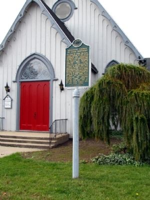
Members of the First Reformed Church in Holland founded this congregation in 1866 to provide a place of worship for the settlers living southeast of town. Heavy immigration from the Netherlands prompted this move. The Dutch language was used . . . — — Map (db m73682) HM
On Church Street, 0.1 miles south of 146th Avenue, on the left when traveling south.
(Side One)
Erected in 1862, this church was the center of the Dutch immigrant community. The first settlers in this area arrived in early 1847 led by the Reverend Albertus C. V. Raalte. In June of that year a separate group of seventy . . . — — Map (db m73685) HM
On East 147th Avenue, 0.5 miles east of South Waverly Road (54th Street), on the right when traveling east. Reported damaged.
The main portion of this building was the residence of George N. Smith, a Congregational missionary to the Indians in this area and at Waukazoo's Village on nearby Lake Macatawa. The mission was named after an Indian convert. Built in 1844-45 by . . . — — Map (db m73683) HM
On E. Allegan Street (State Highway 89) east of N. Fair Street, on the left when traveling east.
The Otsego Methodist Church was organized in 1842 and served by a traveling minister. The first church was built on this site in 1847. On December 22, 1889, over 900 townspeople attended the dedication of the present church. Many donated money . . . — — Map (db m69960) HM
On 142nd Avenue at 47th Street, on the right when traveling east on 142nd Avenue.
(Side One)
Overisel
Seeking religious liberty and better economic opportunity in a new land, the Reverend Seine Bolks and a congregation of about two dozen families, left Hellendoorn, Province of Overisel, The Netherlands, on . . . — — Map (db m73646) HM
On Grand Street at Hoffman Street, on the left when traveling north on Grand Street.
All Saints Episcopal Church An Episcopal parish was organized in Saugatauk on All Saints Day, November 1, 1868. Services were held at various locations until 1873. In 1871 the parish purchased property. Detroit architect Gordon W. Lloyd . . . — — Map (db m45324) HM
Near Shore Acres Drive, 0.2 miles west of 138th Avenue.
Chicago inventor and businessman Dorr Felt built this house as a summer home for his wife, Agnes. Felt held numerous patents, mostly notably for the Comptometer, the first machine to do complex calculations. In 1919 Felt purchased more than 750 . . . — — Map (db m73640) HM
On Hoffman Street at Griffith Street, on the left when traveling east on Hoffman Street.
On January 11, 1860, eight years before Saugatuck was incorporated as a village, a council of area Congregational leaders met in the Pine Grove schoolhouse and organized a church. During the summer the congregation built a church on this site, which . . . — — Map (db m45457) HM
On 124th Avenue east of Pearl Street, on the right when traveling east.
In the 1870's the Village of Shelbyville was created by the arrival of the Grand Rapids and Indiana Railroad. Shelbyville was named after the first railroad station agent, Mr. Shelby. Since there was already a Michigan town named Shelby, the . . . — — Map (db m74594) HM
On Lockwood Street at South Second Avenue, on the left when traveling north on Lockwood Street.
Soon after white settlers came to
the area in 1856, J.K. Miller held
religious gatherings at the home
of Daniel and Sarah Carter. These
meetings evolved into the First
Congregational Church, which was
organized on March 2, 1862, with
the . . . — — Map (db m233605) HM
On West Chisholm Street (U.S. 23) south of South 5th Avenue, on the left when traveling north.
In 1861 Bishop Frederic Baraga (1797-1868) trod through snow and icy waters from Sault Ste. Marie to Alpena where he founded a Catholic church. However, it was not until 1866 that Father Patrick Murray became the first resident pastor of the church . . . — — Map (db m121899) HM
On Leer Road at Carr Road, on the right when traveling south on Leer Road.
In the summer of 1879
five Norwegian families
settled what became the
village of Leer. They and
those who followed came
to Michigan seeking to
own their own land. Many
of the men worked in area
lumber camps and Alpena’s
mills until they . . . — — Map (db m233696) HM
On Traverse Street at Pine Street, on the left when traveling west on Traverse Street.
In the late 1850s traveling pastors
began to conduct Methodist services in
Elk Rapids and nearby communities.
First Methodist Episcopal Church was
organized in the early 1870s. Services
were held in a former school and then a
former . . . — — Map (db m234753) HM
On Saint Johns Road at Michigan Route 32, on the left when traveling south on Saint Johns Road.
n 1885 Bohemian immigrants founded Saint John
Nepomucene Catholic Church,
named for the patron saint of
Czechoslovakia. The settlers,
most of whom emigrated from
Prague, named their community Praga. This Gothic
Revival church was built as
a . . . — — Map (db m234149) HM
On Jefferson Street at Green Street, on the right when traveling south on Jefferson Street.
The first Methodist Episcopal Society, the oldest congregation in Hastings, erected this Greek Revival structure in 1860. In 1911 the Methodists built a new church on the northwest corner of Green and Church Streets. The following year it sold the . . . — — Map (db m199125) HM
In 1878 twelve persons organized the Parmelee Methodist Church. The small congregation met at various locations until 1884, when this church was built on land given to the Methodist Trustee Board by Oliver and Bernice Carpenter. On September 15, . . . — — Map (db m215391) HM
On Center Avenue (State Highway 25) at North Jackson Street, on the right when traveling west on Center Avenue.
Side 1
In 1848, James G. Birney and his wife led Bay City's earliest Presbyterian services in a schoolhouse. Birney, an elder in the church, twice ran unsuccessfully for president on the antislavery ticket. The Reverend Lucius Root organized . . . — — Map (db m33696) HM
On Westside Saginaw Road (State Highway 84) at Ziegler Road, on the right when traveling north on Westside Saginaw Road.
Frankenlust
One of four colonies in Michigan settled by people from Franconia, Germany, Frankenlust was founded by Pastor Ferdinand Sievers and fourteen immigrants who established Saint Paul Evangelical Lutheran Church in June 1848. On July . . . — — Map (db m138097) HM
On North Euclid Avenue (Michigan Route 247) at Hidden Road, on the right when traveling north on North Euclid Avenue.
Established in 1847, the Ogaukawning Indian Mission, the first church in present-day Bay County, served Chippewa Indians at the nearby Kawkawlin settlement. First ministered by Methodist missionaries, it soon came under Indian trusteeship and still . . . — — Map (db m182297) HM
On 3rd Street west of North Sherman Street, on the right when traveling west.
St. Joseph was the first Catholic parish in the Saginaw Valley when it was founded in 1850-51 by missionary Joseph Kindekens. Dedicated on March 19, 1911, this building is the third to serve St. Joseph. During the late nineteenth century St. Joseph . . . — — Map (db m162342) HM
On Kosciuszko Avenue west of South Farragut Street, on the right when traveling west.
St. Stanislaus Kostka Roman Catholic Church
In the second half of the nineteenth century, Polish refugees who escaped Prussian domination settled in Bay City. In 1874 they formed a society under the patronage of Saint Stanislaus Kostka of . . . — — Map (db m161004) HM
On South Catherine Street at East Thomas Street (State Route 25), on the left when traveling south on South Catherine Street.
During the 1870s, Swedish immigrants arrived in Bay County. By 1880 many Swedes had settled in West Bay City. In October of that year, fifty people organized the Swedish Evangelical Lutheran Sion Church, affiliated with the Augustana Synod. A year . . . — — Map (db m163096) HM
On Center Avenue (State Highway 25) at North Grant Street, on the right when traveling west on Center Avenue.
Trinity Church
Trinity Church grew from a small group of settlers served by Episcopal missionaries beginning around 1842. Church records credit William and Ann Fitzhugh with founding the church. On March 4, 1854, fourteen people, led by the . . . — — Map (db m33912) HM
On Amelith Road, 0.2 miles west of Kraenzlein Road, on the right when traveling east.
St. John Evangelical Lutheran German missionary Pastor Ferdinand Sievers organized St. John Church in June 1852 to serve a colony of German migrants, some fleeing the turmoil that followed the European revolutions of 1848. Initially, the church . . . — — Map (db m180379) HM
On Michigan Avenue (U.S. 31) north of Traverse Avenue, on the left when traveling north.
In 1858, in what was then a remote wilderness, the Rev. Charles E. Bailey and four families from his Ohio Congregational parish founded Benzonia colony. It was to be an "educational Christian colony" modeled after the earlier Congregational . . . — — Map (db m97478) HM
On Michigan Avenue (U.S. 31) north of Traverse Avenue, on the right when traveling north.
This building was a girls dormitory erected in 1909 for the Benzonia Academy. Named Mills Cottage in honor of the Reverend Harlow S. Mills, pastor of Benzonia Congregational Church from 1896 to 1916, it became property of that church when the . . . — — Map (db m97479) HM
On Forest Avenue at 5th Street, on the right when traveling west on Forest Avenue.
On January 26, 1868, twenty-three early Frankfort residents founded First Congregational Church of Frankfort. They received guidance from an established Congregational Church in Benzonia, Michigan. In accordance with the practices of . . . — — Map (db m168222) HM
On East Britain Avenue at Eastman Avenue, on the left when traveling west on East Britain Avenue.
(Obverse Side)
Israelite House of David
Based on the teachings of the Christian Israelite tradition begun by Joanna Southcott in England in 1792. Benjamin and Mary Purnell founded the House of David communal religious community in . . . — — Map (db m64809) HM
On Eastman Avenue south of E. Britain Avenue, on the right when traveling south.
Officially beginning on 14 March, 1930, Mary Purnell’s reorganization of the Israelite House of David began in a very humble fashion on newly acquired properties along Britain and Eastman Avenues. With four agricultural properties, an unfinished and . . . — — Map (db m81805) HM
On JN Andrews Boulevard at Old US 31 (Michigan Highway 139), on the right when traveling north on JN Andrews Boulevard.
This, the oldest Seventh-day Adventist college and the pioneer in a world-wide system of Christian education, was chartered in 1874 at Battle Creek as Battle Creek College. It was moved to Berrien Springs in 1901 where its name was changed to . . . — — Map (db m64917) HM
On North Cass Street (State Highway 139) at West Union Street, on the right when traveling south on North Cass Street.
This building, a fine example of the Greek Revival style, was designed by Gilbert B. Avery in 1838. James Lewis, the contractor, agreed to complete the building by April, 1839. Built almost entirely of whitewood, the courthouse has hand-hewn . . . — — Map (db m64918) HM
On Pokagon Road at State Highway 140, on the right when traveling east on Pokagon Road.
In 1857 Protestants of different denominations established a church and cemetery on property purchased from Zera and Eliza Wright. They dedicated the Greek Revival-style Union Church on July 4, 1858. The denominations held services on alternating . . . — — Map (db m64939) HM
Near Madaline Street, 0.1 miles west of Adams Road, on the right when traveling west.
Here, in 1837, in the then flourishing settlement of Bertrand, a fine brick church, dedicated to St. Joseph, was built to serve the Catholics of this area. In this church, on September 8, 1844, the habit of the Sisters of the Holy Cross was given . . . — — Map (db m64931) HM
On Orange Road, 0.2 miles south of West Chicago Road, on the right when traveling south.
(Side 1)
Persuaded by reports of good land from the Reverend John Seybert, Bishop of the Ohio Conference, the Jacob and David Rough families came to Portage Prairie from Pennsylvania in the spring of 1849. In 1851 they organized the Zion . . . — — Map (db m64835) HM
Near Bond Street, 0.3 miles north of Front Street, on the right when traveling north.
To the memory of
Father Claude Jean Allouez S. J.
Whose intrepid courage won the admiration of the Indians and whose apostolic zeal earned for him the title of the Francis Xavier of the American Missions. Father Allouez was born at St. . . . — — Map (db m68554) HM
On Pucker Street at Chapel Road, on the right when traveling north on Pucker Street.
The local Methodist Episcopal Society, the oldest Methodist society in Berrien Township, was organized in 1840. In 1846 it voted to name its church in honor of Bishop Thomas A. Morris, then the head of the Methodist Episcopal Church in Michigan. . . . — — Map (db m64952) HM
On South Lincoln Avenue (Business U.S. 12) near Clay Street.
The Roman Catholic Church in Niles traces its origin to the Indian Mission established at nearby Fort St. Joseph in the late 1600’s. Reestablished at Bertrand, three miles south of Niles, in the 1830s, the mission moved into town in 1849 and was . . . — — Map (db m1606) HM
On Ferry Street near North 5th Street (Michigan Highway 51).
In 1851 the Reverends J.W. Hackley and D.G. Lett organized the Second Baptist Church under the Anti-Slavery Baptist Association. The first of four churches—a log building—was erected on the southeast corner of Sixth and Ferry streets. In . . . — — Map (db m1607) HM
This is the oldest existing church structure in Niles, located in the oldest Episcopal parish in the Diocese of Western Michigan. The first Episcopal service in Niles was conducted by Bishop Philander Chase in 1832. The parish was organized in 1834. . . . — — Map (db m1634) HM
In 1839 circuit riders from Ohio began preaching in Niles, using the barroom of a local hotel. In 1832 nine worshipers formed the Methodist class that grew to be the Wesley United Methodist Church. They dedicated their first house of worship in . . . — — Map (db m1605) HM
On Lakeshore Road at Apple Avenue, on the right when traveling south on Lakeshore Road.
Built in 1924 by Louis and Lena Gordon, and expanded four years later, Gordon Beach Inn was the centerpiece of the Jewish resort subdivision of the same name. The Gordons operated the inn for a decade before losing it during the Great Depression. . . . — — Map (db m64829) HM
On Willow Lane at West Chicago Street, on the left when traveling north on Willow Lane.
Allen Tibbets an itinerant Methodist minister
who preached the gospel for 15 years came to this
prairie in 1830 and purchased 80 acres in section 22
with the help of Joseph Hatchett who owned the adjoining
land in 1831 he plotted a village which . . . — — Map (db m165462) HM
On Marshall Street (Old U.S. 27) at Church Street, on the right when traveling north on Marshall Street.
Organized in 1837, the same year that Coldwater became a village, the local Presbyterian society held services in various quarters until 1844 when it erected its first church. It completed the present Romanesque Revival-style brick church in 1869 at . . . — — Map (db m122218) HM
On Marshall Road (Old U.S. 27) 0.1 miles south of East Girard Road, on the right when traveling south.
Methodists held the first religious services in Girard Township. Organized in 1832 by the Reverend Ezekiel Gavit, a circuit rider, the congregation met in homes and a school until a church was built in 1844. When that structure burned in 1887 it was . . . — — Map (db m165218) HM
On North Broadway Street, 0.1 miles north of Allen Street, on the right when traveling north.
On March 7, 1837, the Reverend Calvin Clark of Homer led sixteen people in organizing the First Congregational Church of Union City. The congregation is likely the oldest of this denomination in the state. This Romanesque Revival building dates from . . . — — Map (db m65805) HM
On Ellen Street at Ann Street, on the right when traveling west on Ellen Street.
(Side One)
During 1836-37, cabinetmaker David Hull led the organization of the township's first religious society. Circuit-riding ministers held services for Union City's fledgling Methodist congregation on alternate Sundays. The group . . . — — Map (db m65806) HM
On East Porter Street at South Monroe Street, on the right when traveling west on East Porter Street.
(Front)
In February 1837 the Reverend Calvin Clark, a circuit riding pastor sent by the American Home Missionary Society, met with twenty-four persons and organized the Albion Presbyterian Church. The first church was built in 1840 on the . . . — — Map (db m28378) HM
On State Street at Austin Avenue (State Route 199), on the right when traveling north on State Street.
In 1904 the Albion Malleable Iron Company began recruiting workers for its foundry. The arrival of six Russians from New York City marked the beginning of Albion's "Foreign Colony." By 1915 the Foreign Colony had grown to around 600 people of . . . — — Map (db m177134) HM
On East Cass Street, on the left when traveling west.
The Albion College Astronomical Observatory was built in 1883-84 at the urging of Dr. Samuel Dickie, who later became president of the college. Dickie helped raise $10,000 to build and equip the facility. The observatory still harbors its original . . . — — Map (db m27743) HM
On West Van Buren Street at North Cass Street, on the right when traveling west on West Van Buren Street.
In 1855 Elder James Brown and his wife, Radley, established an African Methodist Episcopal Church in Battle Creek. The congregation met in members’ homes until 1860 when it moved into a church on the northeast corner of Maple and Van Buren Streets. . . . — — Map (db m177260) HM
On Michigan Avenue, 0.1 miles north of South Division Street, on the right when traveling south.
The First Baptist Church, oldest church in Battle Creek, was organized in April 1835, with nineteen charter members. Meetings were held in the log schoolhouse the first few years. The present site was bought from Sands McCamley in 1843 for $275. The . . . — — Map (db m177332) HM
On Capital Avenue Northeast near Division Street North, on the right when traveling west.
Congregationalists joined Presbyterians in organizing a church in 1836. When a split occurred in 1883, they formed the Independent Congregational Church. Chicago architect Joseph C. Llewellyn designed this Neo-classical church, built in 1907, to . . . — — Map (db m177272) HM
Near South Avenue just south of East Burnham Street, on the right when traveling south.
James S. and Ellen G. White were among the founders of the General Conference of the Seventh-day Adventist Church, which was organized in Battle Creek in 1863. Long participants in the Adventist movement, they cam to Battle Creek in 1855 when the . . . — — Map (db m144851) HM
On East Michigan Avenue at Division Street North, on the left when traveling south on East Michigan Avenue.
The first Methodist class in this area met in the home of Daniel Thomas in 1833. Three years later services were being held in the log schoolhouse. In 1841 the first structure for religious services in the village was built by the Methodists 150 . . . — — Map (db m177334) HM
On North Washington Avenue at Vineyard Avenue, on the right when traveling south on North Washington Avenue.
Calling themselves the Second Baptist Society, a small group of Battle Creek African Americans worshipped in their homes prior to 1849. That year, led by the Reverends Parmelee and Harris of the white First Baptist Church, they officially organized . . . — — Map (db m177254) HM
On North Washington Avenue at North Washington Avenue, on the right when traveling south on North Washington Avenue.
Battle Creek is closely identified with Adventist history. The first church built by Seventh-Day Adventists was erected here in 1855 and the General Conference organized in 1863. The denomination’s first world headquarters, publishing house, . . . — — Map (db m177259) HM
On Capital Avenue Northeast at West Van Buren Street, on the right when traveling north on Capital Avenue Northeast.
The Quaker meetinghouse on this site was purchased at auction by local Catholics in 1863. St. Philip Roman Catholic Church has been on this corner since then. Its first school opened in 1880. The current Romanesque building, dedicated in 1930 after . . . — — Map (db m177273) HM
On Capital Avenue Northeast at East Van Buren Street, on the right when traveling north on Capital Avenue Northeast.
In 1839 Battle Creek’s first Episcopal service was conducted. Regular services were held in the schoolhouse after 1841 by the Rev. Montgomery Schuyler, then rector at Marshall. In appreciation he was given a team of horses. In 1842 Bishop Samuel . . . — — Map (db m177275) HM
On South Sophia Street at West Everett Street, on the right when traveling south on South Sophia Street.
The First Presbyterian Church of Homer was organized with thirty-four members under the direction of the Reverend Elijah Buck in 1838. Shortly afterwards, services were held in the “Session House,” which served the group until 1853, when the . . . — — Map (db m223759) HM
On Michigan Avenue (Business Interstate 94), on the right when traveling east.
The Reverend Thomas Z.R. Jones, a traveling missionary, began visiting the Marshall area in 1838. On January 16, 1840, he helped organize the First Baptist Church of Marshall with eight members. The group erected this church in 1850-51. They . . . — — Map (db m225881) HM
On Hobart Road at North Kalamazoo Avenue, on the right when traveling west on Hobart Road.
Randall Hobart arrived in Marshall
in 1831 as a lay preacher who helped
organize the local Methodist Church.
He served as the Justice, who delayed
the Kentucky slave hunters long
enough to allow the Adam Crosswhite
family to escape to Ontario . . . — — Map (db m189341) HM
On West Mansion Street, on the right when traveling west.
On this foundation stood the log house of the Reverend John D. Pierce. Born in New Hampshire, Pierce moved to Marshall in 1831, where he founded the Congregational church. In 1834 he and Isaac Crary designed Michigan's school system, and from 1836 . . . — — Map (db m28394) HM
On West Mansion Street at North Eagle Street, on the right when traveling west on West Mansion Street.
The city of Marshall was platted in 1830 by Sidney Ketchum, a land speculator from Clinton County, New York. In 1832 townsfolk erected their first public building, a modest frame schoolhouse, on land donated by Isaac E. Crary, who became one of the . . . — — Map (db m177246) HM
On East Mansion Street at North Jefferson Street, on the right when traveling west on East Mansion Street.
Trinity Episcopal Church Trinity parish was organized in 1836. Early services were held in a log schoolhouse. The Rev. Samuel Buel assumed duties as the first pastor in 1838. This native Marshall sandstone building, with its Victorian interior, . . . — — Map (db m177244) HM
On Chain Lake Street, 0.6 miles east of Carver Road, on the right when traveling east.
In the 1830s southern runaway slaves bound for freedom in Canada came into Michigan near Cassopolis. In 1840, Cass County's Quaker community, which provided a haven for the fugitives, became an integral part of the Underground Railroad. Many free . . . — — Map (db m64712) HM
On Middle Crossing Road at Garrett Road, on the right when traveling west on Middle Crossing Road.
Circuit-riding ministers established a Methodist class in Silver Creek Township in 1843. Five families attended the earliest meetings, held in the home of Leroy L. Curtis, the first class leader. In 1844 the Reverend David Whitlock was appointed . . . — — Map (db m64737) HM
On Leach Road, 0.2 miles north of Topash Street, on the right when traveling north.
Chief Leopold Pokagon and his tribe of Potawatomi Indians built a log church here in 1838 and deeded the forty acres of land on which it stood to the Catholic Bishop of Detroit. Pokagon, who came to Silver Creek Township from his village outside of . . . — — Map (db m64735) HM
On Courtland Street, 0.1 miles west of Center Street, on the right when traveling west.
(Obverse Side)
St. Paul's Church
Under the leadership of Justus Gage (1805-1875), this structure was built as a Universalist church. Completed at a cost of $3,000, it is Dowagiac's oldest public building. At the time of completion, . . . — — Map (db m64731) HM
On Vermont Street at Kansas Street, on the right when traveling north on Vermont Street.
The Old Rugged Cross Church has been placed on the National Register of Historic Places by the United States Department of the Interior
1876 — — Map (db m217932) HM
Near Redfield Rd, 0.4 miles west of Brush Road, on the right when traveling west.
The first Methodist church in Milton Township was organized in 1839. The following year, this church was built and named Smith's Chapel to honor Canon Smith, who had contributed generously to the construction of the church. Smith, a native of . . . — — Map (db m64740) HM
On Lake Street at Church Street, on the right when traveling north on Lake Street.
In 1831, Luther Humphrey of the American Home Missionary Society organized the Presbyterian Church of Edwardsburg. He described the village as "a few log cabins...standing amongst the bushes and brush." Members worshipped in homes until the chapel . . . — — Map (db m122217) HM
On Born Street at Patterson Hill Road, on the right when traveling west on Born Street.
In 1835, George Poe (1779-1851) emigrated from Crawford County, Ohio, and settled on land deeded to him by the U.S. government. Within two years he acquired 520 acres of land in Newberg Township. Many members of the Poe family settled in this . . . — — Map (db m64546) HM
On Vermont Street at Kansas Street, on the left when traveling south on Vermont Street.
Methodist Episcopal Church
Circuit-riding Methodist ministers held religious services in Pokagon Township during the 1830s and 1840s. A class was organized in Sumnerville in 1840. In 1876 the Methodists purchased this building, which had . . . — — Map (db m64747) HM
On James Street, 0.1 miles north of Brownsville Road, on the right when traveling north.
Quakers from the mid-Atlantic region settled here during the 1830's. This is the site of the meeting house, built in 1856, which replaced a log cabin dating from 1837. The congregation contained many active Abolitionists, and this area soon became . . . — — Map (db m68407) HM
On South Park Street at East Pine Street, on the right when traveling south on South Park Street.
In 1874 the Reverend Andrew
Wiggins and twelve pioneers
organized the Methodist-Episcopal Church of Boyne
City, near Deer Lake. In
1883, Zachariah Morgan and
his wife, Mary, donated land
on which to build a church.
The first church was . . . — — Map (db m234146) HM
On State Street at Park Avenue, on the left when traveling north on State Street.
The First Congregational Church was formed in 1882. Members purchased this lot in 1883, and the building was completed in 1885. Church women held social fundraisers to help finance its cost. The building features rare Stick style motifs. The . . . — — Map (db m98093) HM
On Green Sky Hill, 0.2 miles east of Old U.S. 31, on the right when traveling south.
Here in the 1840's the Chippewa Indian missionary, Peter Greensky, established a Protestant mission in an area where legend says Indian chiefs once held their councils. New trees have been planted in an arrangement similar to that of the trees that . . . — — Map (db m215921) HM
On Court Street east of South Huron Street, on the right when traveling east.
When Cheboygan County was organized in 1853, the courthouse was located in Duncan (now a part of the city of Cheboygan). In 1860 the county board of supervisors moved the county seat to Inverness Township and purchased this property from Bela . . . — — Map (db m121798) HM
On North D Street north of State Street (U.S. 23), on the right when traveling north.
Father Andrew D. Piret, a priest
serving the Mackinac Island mission,
celebrated the first mass of the St.
Mary’s congregation in the home of
Charles Bellant in 1852. Four years
later, the parish_built a temporary
chapel on Peter McDonald’s . . . — — Map (db m233774) HM
On North Whitefish Point Road, 0.5 miles north of West North Shore Road.
This light, the oldest active on Lake Superior, began operating in 1849, though the present tower was constructed later. Early a stopping place for Indians, voyageurs, and Jesuit missionaries, the point marks a course change for ore boats and other . . . — — Map (db m40054) HM
On East Spruce Street at Bingham Avenue, on the right when traveling west on East Spruce Street.
This Richardsonian Romanesque church was erected in 1892-93 according to plans by Bay City architect Dillon P. Clark. It is one of several builldings in the city constructed of red "canal rubble" sandstone discarded during a power canal . . . — — Map (db m213409) HM
On East Portage Avenue (Interstate 75 Spur) near Kimball Street, on the right when traveling east.
In memory of the first Mission Church the first building erected in the north country on or near this spot by Father James Marquette S.J. Year 1668 — — Map (db m214290) HM
On Riverside Drive, 0.9 miles north of Gardenville Road, on the right when traveling north.
Several Methodist ministers were active in missionary work in the "Soo" area in the 1830s. John Sunday, an Indian preacher from Canada, began mission work in the Indian settlement at the Sault Ste. Marie Rapids around 1831. The Reverend John . . . — — Map (db m213422) HM
On East Water Street at Bingham Avenue, on the right when traveling east on East Water Street.
On this site in 1668 was built the first permanent wooden structure in what is now the state of Michigan. This was St. Mary's Church erected by the French Jesuit fathers Jacques Marquette and Louis Nicholas to minister to the Ojibwe community. The . . . — — Map (db m214153) HM
On East Portage Avenue (U.S. 75 Spur) near Kimball Street, on the right when traveling east.
In 1853, Pope Pius IX separated the Upper Peninsula from the Diocese of Detroit and established a vicariate apostolic. Reverend Frederic Baraga, a missionary from L’Anse, became vicar apostolic and made St. Mary’s Church his headquarters. In 1857 . . . — — Map (db m213449) HM
On East Water Street at Brady Street, on the right when traveling east on East Water Street.
This statue of St. Mary is placed in this location to reflect the namesake of the St. Marys River and the twin cities of Sault Ste. Marie. It was originally located in the Sisters of Charity Hospital in Detroit for many years and moved to this . . . — — Map (db m214162) HM
On West 5th Street (State Highway 115) at Beech Street, on the right when traveling west on West 5th Street.
Saginaw architect William T. Cooper designed this church in a Greek cross plan. The church, built in 1909, is one of only a few in Michigan that reflect how early twentieth-century Protestants adopted the architecture of the fifth- and sixth-century . . . — — Map (db m98777) HM
On North Main Street, on the right when traveling north.
Village of Ovid
In 1836, inhabitants of Ovid, Seneca Falls County, New York, began to settle this fertile farm area. Among them were Samuel Barker, who built his log cabin in "Section 6;" Jabez Denison, noted for his prowess in killing . . . — — Map (db m119352) HM
On Maple Road at G Street, on the right when traveling west on Maple Road.
In 1836 a Rochester, New York, association purchased land here and by winter several families were settled in newly built log homes. Methodist circuit riders in 1837 organized a class which became center of the three-county Mapleton circuit. In 1841 . . . — — Map (db m217494) HM
On North Scott Road at West Marshall Road, on the right when traveling south on North Scott Road.
The Reverend William Benson organized a Methodist class for this area in 1849. The class, which had seven members, held its first worship service in a log school south of Eureka. Later it met in the Sherwood School and the Keystone Grange Hall. . . . — — Map (db m217225) HM
On North Westphalia Street at Church Street, on the right when traveling south on North Westphalia Street.
Westphalia Settlement
In October 1836 the Reverend Anton Kopp and five other men from Westphalia, Germany, arrived in New York. They traveled to Detroit by way of the Erie Canal. Advised to settle in the Grand River Valley, the Reverend Kopp . . . — — Map (db m215916) HM
On Michigan Avenue at Spruce Street, on the right when traveling north on Michigan Avenue.
In 1882, residents of Grayling built the town's first church for the Methodist Episcopal congregation that had organized in 1879. In 1918, local lumberman Nels Michelson donated funds to erect a large brick church in honor of his late wife, . . . — — Map (db m95652) HM
On Kent Street at Fairbanks Street/Carpenter Avenue, on the left when traveling east on Kent Street.
Iron Mining began on the Menominee range in 1879, and soon after the first Italians arrived. They were primarily from Piedmont, Trentino, Lombardy, Venetia, Abruzzo Molise, Latium, Friuli, Calabria, Sicily, Emilia-Romagna, and Liguria. By 1910 they . . . — — Map (db m143660) HM
On Blaine Street at Millie Street, on the right when traveling west on Blaine Street.
Maria Santissima Immacolata di Lourdes
In the late nineteenth and early twentieth centuries Italian immigrants came to Iron Mountain to work in the iron mines. In 1890, Italian Catholics from the community’s north side organized what was . . . — — Map (db m106024) HM
On Cochran Avenue (Business Interstate 69) south of Tirrell Street, on the left when traveling south.
This building served as Eaton County's courthouse from 1846 to 1872. The first courthouse was built in Bellevue in the 1830s. In 1840, Charlotte became the county seat, and in 1844 the county supervisors voted to erect a new courthouse on the . . . — — Map (db m216458) HM
On Narrow Lake Road, 0.1 miles east of Brookfield Road, on the left when traveling east.
On November 30, 1878, the local Methodist class purchased land for a church from Benjamin and Catherine Spotts for $25.00. Church men cut and hewed the logs for the building. The Reverend B. E. Paddock dedicated the church on November 10, 1881. . . . — — Map (db m126010) HM
540 entries matched your criteria. The first 100 are listed above. Next 100 ⊳