On Harbor Loop south of Rogers Street (Massachusetts Route 127), on the right when traveling south.
"King of the Mackerel Killers"
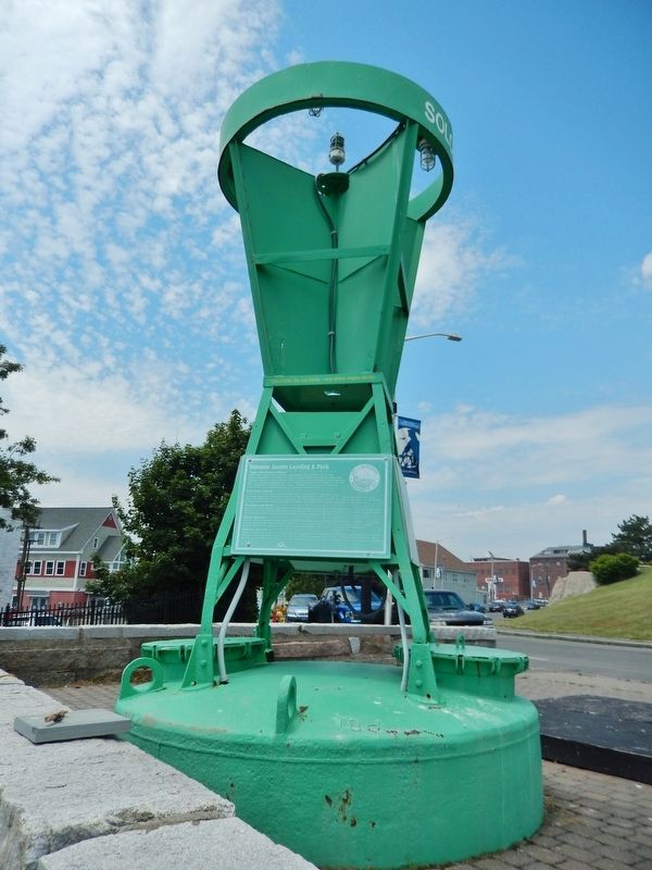
Solomon Jacobs Landing & Park were named for Captain Solomon Jacobs, who fished in the early 1900s.
A native of Newfoundland, he was known as the "King of the Mackerel Killers" for his ability to land huge . . . — — Map (db m115472) HM
On Western Avenue (Massachusetts Route 127) at Middle Street, on the right when traveling north on Western Avenue.
Before you stretches Ten Pound Island. In 1821 a lighthouse was built on the island to safely direct sailing ships into Gloucester Harbor. Some of America's greatest works of art were painted by Winslow Homer while staying at the keeper's house in . . . — — Map (db m36436) HM
The Brig Falconer was wrecked on Ipswich Beach December 17, 1847. Seventeen of the passengers and crew were lost. Twelve lie buried here in one common grave.
Thomas Shaw, and his wife • Julia Laskin • Margaret Hennesy • Howard Fling • Peter . . . — — Map (db m107994) HM
Near Front Street at Fort Sewall Terrace, on the right when traveling north.
Fort Sewall
Marblehead Massachusetts
Marblehead, founded in 1629, has always been a famous seaport – for fishing, foreign trade, boat building, sail making and yachting. Local sailors have been champions in world competitions, the America's . . . — — Map (db m36608) HM
Near Front Street at Fort Sewall Terrace, on the right when traveling north.
Huzzah! For "Old Ironsides"
Marblehead citizens have embraced
USS Constitution
on three historic visits:
3 April 1814 when beneath the guns of Fort Sewall she found refuge from an overwhelming British force
29-31 July 1931 when under . . . — — Map (db m36606) HM
Near Follett Street, 0 miles north of Kimball Street, on the left.
[Top Marker]
In July of 1789, Representative Elbridge Gerry, native of Marblehead, signer of the Declaration of Independence, and Vice President of the United States under President James Madison, filed H.R. Bill 12 in Congress, . . . — — Map (db m21453) HM
On High Street (Massachusetts Route 113) at High Street & Jefferson Street when traveling east on High Street.
First ferry across the Merrimack river from Newbury to Salisbury, established about 1639, and the only route from Boston to the eastern frontier. In 1641 George Carr was appointed ferryman with rights which continued in his family for generations. — — Map (db m47972) HM
On High Street (Massachusetts Route 1A) at Green Street, on the right when traveling south on High Street.
Brought from the siege of
Louisburg
by Nathaniel Knapp Jr. 1759
preserved by his son
Isaac Knapp
as a memorial to his father
and also to his brother
Jacob Knapp
who served at Bunker Hill
and was a member of the . . . — — Map (db m115543) HM
On Merrimac Street, on the left when traveling west.
“She’s the Liverpool Packet- O Lord, let her go!”
The Dreadnought, in her ten years running in the Atlantic Packet Service, made for herself such a name that she is still remembered: “The wild boat of the Atlantic ,” As . . . — — Map (db m85299) HM
On Bearskin Neck east of Tuna Wharf Road, on the right when traveling east.
Straitsmouth Island was first sighted in 1614 by Captain John Smith. He also spotted nearby Thacher and Milk Islands and named all three the Turks' Heads.
Lighting the Way
Built in 1834, the island's first lighthouse was 19 feet . . . — — Map (db m115515) HM
Near Mt. Pleasant Street (Massachusetts Route 127A) at Broadway, on the right when traveling north.
Town Wharves
First timber wharf built in 1743 to shelter fishing boats. In 1793 62 vessels of 5 to 10 tons were sighted in Rockport Harbor. From incorporation of Sandy Bay Pier Co. in 1811 wharves were rebuilt and extended of durable granite blocks . . . — — Map (db m36262) HM
Near Webb Street north of Andrew Street, on the right when traveling west.
Historic Collins Cove in Salem was once ringed with salt marsh. Restoration began in spring 2019.
Historic Collins Cove in Salem was once ringed with salt marsh. Starting in 1845, Boston and Maine railroad filled the tidelands to transport . . . — — Map (db m233294) HM
On Essex Street at Orange Street, on the right when traveling east on Essex Street.
This house was built in 1750 by
Capt. John Hodges, a West Indies
trader. In 1788, it passed to his son,
Capt. Benjamin Hodges.
Benjamin Hodges (1754 – 1806) was one of Salem’s most distinguished sea captains of the . . . — — Map (db m115326) HM
The grassy strip of land extending into the harbor in front of you was once a busy commercial wharf. In the late 1700’s and early 1800s, trade goods from around the world were loaded, unloaded and stored here.
Build in 1784, Central Wharf was . . . — — Map (db m86467) HM
Near Derby Street just west of Palfrey Court, on the left when traveling east.
These quiet backyards of historic houses once formed a neighborhood—and a history—all their own.
For a hundred years, a cluster of flats and tenements lined a 200 foot dead-end alley called Custom House Place. Though predominantly Irish in . . . — — Map (db m186240) HM
On Derby Street just west of Palfrey Court, on the left when traveling east.
The Derby House is the oldet surviving brick building in Salem, and one of the finest examples of Georgian architecture in the city.
Wealthy merchant Richard Derby, Sr. built this house in 1762 as a wedding present for his second son, Elias . . . — — Map (db m186237) HM
On Derby Street at Orange Street, on the right when traveling east on Derby Street. Reported missing.
The wharf in front of you was Salem’s longest, and was once one of the busiest in the nation. During the War of Independence, American privateers sailed from here to prey on British ships on the high seas. After the war, fleets of trading vessels . . . — — Map (db m86544) HM
On Derby Street at Orange Street, on the right when traveling east on Derby Street.
The wharf in front of you was Salem’s longest, and was once one of the busiest in the nation. The first 800 feet of the wharf was begun in 1762 and completed about 1770 by Capt. Richard Derby, Sr. (1712-1783), one of the wealthiest merchants in . . . — — Map (db m86545) HM
Near Derby Street east of Orange Street, on the right when traveling north.
Friendship of Salem is a full-size, fully
operational replica of Friendship, a cargo ship
built in Salem, Massachusetts in 1797 for
merchants Jerathmiel Peirce and Aaron Waite.
Friendship was an East Indiaman, built for
international trade. The . . . — — Map (db m221273) HM
On Lafayette Street, on the right when traveling north.
A Cooperative Project Between the City of Salem, the Town of Marblehead, and the Commonwealth of Massachusetts PARC Grant Program
Conserved 2013
This 4.23-acre public green space lies on the Salem-Marblehead boundary at the mouth of the . . . — — Map (db m221283) HM
Near Derby Street, on the left when traveling east.
The modest house in front of you is one of the oldest in Salem. Built in 1675, the Narbonne House is one of America's few surviving middle-class homes from the 17th century.
Thomas Ives, the building's first owner was a "slaughterer" or . . . — — Map (db m233306) HM
Near Derby Street, 0.3 miles south of Orange Street. Reported missing.
If Salem was once a prosperous world seaport, it was not due to the geography of the harbor, but to the enterprise of her seamen, tradesmen, and merchants.
Unlike other major ports such as New York, Salem Harbor had no major river to link it . . . — — Map (db m86541) HM
If Salem was once a prosperous world seaport, it was not due to the geography of the harbor, but to the enterprise of her mariners, tradesmen, and merchants. Unlike other major ports such as New York, Salem Harbor had no major river to link it . . . — — Map (db m220595) HM
Salem Maritime National Historic Site-Welcome to Salem Maritime National Historic Site, a unit of the National Park System. Since 1938, this park has preserved the wharves and historic buildings associated with Salem’s prosperous years of overseas . . . — — Map (db m86463) HM
On Essex Street at Hawthorne Boulevard (Massachusetts Route 1A), on the left when traveling west on Essex Street.
The home in which author Nathaniel Hawthorne was born on July 4, 1804 once stood near this spot. The Georgian-style house, two-and-a-half stories high and two byas wide, was built for blacksmith Jonathan Phelps between 1745 and 1750. In 1772, . . . — — Map (db m186223) HM
On Derby Street at Orange Street, on the right when traveling east on Derby Street. Reported missing.
Inside this impressive building were the offices of the United States Customs Service collectors, inspectors, and other officials. It was here that ship’s captains and owners paid duties on imported goods, ordinarily about 5% of their value. . . . — — Map (db m23857) HM
Inside this impressive building were the offices of the United States Customs Service collectors, inspectors, and other officials. It was here that ship’s captains and owners paid duties on imported goods and conducted other business.
Before . . . — — Map (db m86927) HM
On Derby Street just west of Palfrey Court, on the right when traveling west.
By 1780, the nearly 20-year-old brick Derby House behind you was small and out of fashion for a family growing in size and wealth. The Derbys hired noted architect Samuel McIntire to design and build an enormous 5,000 square foot, three-story . . . — — Map (db m186239) HM
On Derby Street at Palfrey Court, on the right when traveling east on Derby Street.
Captain Henry Prince (1764-1846) built the store across the street about 1800 while living in the brick house next door, which he purchased from famed merchant Elias Hasket Derby. It is assumed Prince used the store as a warehouse for cargo. . . . — — Map (db m186246) HM
Near Derby Street, on the right when traveling east.
If you visited Salem’s waterfront in the late 1700s or early 1800s you would have been impressed not only by the ships and their exotic cargo, but also by the variety of artisans and craftsmen who worked on the wharf. Sail makers, riggers, rope . . . — — Map (db m220594) HM
Not until the later 1800s did we have photographs of sailing vessels berthed along wharves here, but by then we had declined as a world port. The shallow harbor could not accommodate the clipper ships and larger vessels that dominated the seas after . . . — — Map (db m62541) HM
On Derby Street at Orange Street, on the right when traveling east on Derby Street.
The earliest photographs of Salem's wharves date from the late 1800s, as the great age of sail was coming to an end. Salem achieved its greatest trade successes in the early 1800, and saw a decline throughout the 19th century. One reason was the . . . — — Map (db m186242) HM
On Interstate 95 at milepost 90 south of New Hampshire State Line, on the left when traveling south.
This 90-mile roadway links 14 coastal communities from Lynn to Salisbury and features scenic views, period architecture, historic sites and recreational opportunities throughout.
1. Lynn
Lynn, the southernmost community on the Essex . . . — — Map (db m220847) HM
On Humphrey Street (Massachusetts Route 129) at Greenwood Avenue, on the left when traveling north on Humphrey Street.
In Memory Of The Men
Of Swampscott Who Lost Their
Lives At Sea
This Anchor Believed To Be From
The Bark "Tedesco" Wrecked January 18, 1857
And Found Off Swampscott August, 1968 By
Mark Cheevers • William Clarke • Mark O'Grady • Kevin . . . — — Map (db m36697) HM
Near Old Main Street near Academy Lane, on the left when traveling north.
During the last ice age, a glacier one-mile thick towered over the spot where you are standing. When it began to melt about 16,000 years ago, the water backed up in the valley creating a giant lake 220 miles long. Early geologists named it Lake . . . — — Map (db m230715) HM
Near Old Main Street north of Academy Lane, on the right when traveling north.
The Deerfield and Connecticut Rivers shape the geography, economy and culture of this region.
Through the trees to the west you can see a dramatic curve, or oxbow, of the Deerfield River. From its headwaters in Vermont's southern Green . . . — — Map (db m230722) HM
On Deerfield Street (U.S. 5) north of Washington Street, on the left when traveling north.
Brookie was created by John Sendelbach of nearby Shelburne Falls. It celebrates the industrial roots of Greenfield , the location of the first cutlery factory in the United States to use the American factory system. The John Russell . . . — — Map (db m230665) HM
On Deerfield Street (U.S. 5) north of Washington Street, on the right when traveling south.
John Russell dreamed of creating a source of metal tool products in the United States. He starts with a small facility, J. Russell & Company, on land just east of the Museum of Our Industrial Heritage in Greenfield. The factory runs on steam . . . — — Map (db m230667) HM
On North Main Street, on the right when traveling north.
Erected August
1838
—
On this Ground Capt. Thomas Lathrop and eighty four men under his command, including eighteen
teamsters from Deer field, conveying stores from that town to Hadley, were ambuscaded by about
700 . . . — — Map (db m37542) HM
On Front Street at Center Street (Massachusetts Route 116), on the right when traveling west on Front Street.
For 150 years this cluster of red brick mill buildings on the Chicopee River served as the community's industrial anchor. The complex was conceived, designed and built by America's first generation of venture capitalists, the legendary Boston . . . — — Map (db m56051) HM
On Huntington Road (Massachusetts Route 112) 0.4 miles north of Kimball Road, on the right when traveling north.
( upper left inset )
A Wild River
Splashing over waterfalls, nourishing farmland and flowing past deep forests and historic New England towns, the Westfield is one of America's great rivers. Over 78 miles of its branches and . . . — — Map (db m157956) HM
On Gerry's Landing Road at Greenough Boulevard on Gerry's Landing Road. Reported missing.
Here at the river’s edge the settlers of Watertown led by Sir Richard Saltonstall landed July 30, 1630.
Here Reverend George Phillips protest in 1632 against taxation without representation struck the first note of civil liberty heard in this . . . — — Map (db m43365) HM
On Webster Avenue just north of Lilac Court, on the right when traveling north.
William Wells Brown, an escaped slave who became the first African American novelist, was born on the Kentucky plantation of Dr. John Young. Later he was owned by three different masters in the St. Louis area. At one point he was a handyman in . . . — — Map (db m215264) HM
On Massachusetts Ave. (Massachusetts Route 4) at Barnes Place, on the right when traveling north on Massachusetts Ave..
Born in Hesse-Darmstadt September 4, 1796 A fearless advocate of Liberty and Justice. Exiled for conscience sake, he sought in America the freedom denied him in the Old World. Distinguished for rich and varied learning, for uncompromising devotion . . . — — Map (db m19194) HM
Near Bedford Street (Massachusetts Route 225) at Massachusetts Ave (Massachusetts Route 4), on the right when traveling north.
Dedicated to the memory of those who served aboard a ship named Lexington ----------------- April 18, 1988 ----------------- The Lexington Lions Club U.S.S. Lexington CV-16 Association 1st Lexington 16 Gun Brigantine Originally the merchantman . . . — — Map (db m18634) HM
Engineer James B. Francis knew that the city of Lowell needed protection from floods. He studied the Merrimack River and understood the dangers of flooding introduced by the canals flowing through the city. The Guard Locks controlled the normal . . . — — Map (db m48418) HM
On John Street, 0.1 miles north of French Street, on the right when traveling north.
The Boott Cotton Mills complex is one of the finest examples of mill architecture in the United States. The mill complex you see today resulted from many decades of expansion and adaption.
[Top left diagram]
1830s
Four mill buildings were . . . — — Map (db m117856) HM
Boott Dam
Beneath the gatehouse to your left is a dam that controls the level of water in the Eastern canal. When the water is high, the excess spills into the Merrimack Wasteway and returns to the Merrimack River.
Booth Penstock . . . — — Map (db m117815) HM
On Suffolk Street at Father Morissette Boulevard, on the right when traveling north on Suffolk Street.
The productivity of thousands of millworkers depended on the skill of gatekeepers like those who worked here at Tremont Gatehouse. By opening and closing sluice gates inside the small brick structure, the gatekeeper controlled the flow of water and . . . — — Map (db m66210) HM
On Father Morissette Boulevard west of Suffolk Street, on the right when traveling west.
The original Suffolk Mill buildings, constructed in 1831, were razed and rebuilt during the idle business years of the Civil War. Only the 1831 counting house survives. The company merged with the Tremont Mills across Suffolk Street in 1871, and new . . . — — Map (db m117840) HM
“It is awful to think of what would have been the inevitable result if the new works had not been constructed … A mighty and uncontrollable river would have swept through the heart of Lowell, destroying everything in its course.” . . . — — Map (db m42037) HM
On Kirk Street near French Street, on the right when traveling north.
In 1821 Hugh Commisky led a band of laborers on a trek from Charlestown to Lowell. With muscle and sweat they dredged canals in the soil of rugged farmland. As others joined in their toil a complex waterpower system evolved, creating a new era of . . . — — Map (db m1620) HM
Near School Street north of Pawtucket Street, on the right when traveling south.
It took a small army of employees to operate Lowell's canals. Every springtime, they repaired damage caused by the harsh New England winter. In a blacksmith shop near the dam, they straightened iron pins to hold new wooden flashboards atop the . . . — — Map (db m198136) HM
On Arlington Road at Hudson Street, on the right when traveling south on Arlington Road.
Old Middlesex Canal
Horn Pond Locks
Along what is now Arlington Road were formerly located three sets of
double locks on the Old Middlesex Canal.
These sets of 80 foot by 11 foot chambers effected a rise of fifty feet for
the . . . — — Map (db m133905) HM
On Baxter Road north of Bayberry Sias Lane when traveling north.
If you were on this spot 23,000 years ago you'd be facing a sloping wall of ice--a massive glacier was 1000 miles away in Northern Canada. Two lobes of that Laurentide Ice Sheet, the Cape Cod Boy Lobe to the west and the South Channel Lobe to the . . . — — Map (db m179352) HM
On Baxter Road north of Bayberry Sias Lane when traveling north.
1789
President George Washington signs into law the creation of the U.S. Lighthouse Establishment under the first Secretary of Treasury, Alexander Hamilton.
1807
Congress establishes the U.S. Coastal Survey.
1842-1845 . . . — — Map (db m179350) HM
Dangerous shoals, left behind by glaciers, lie to the east of this spot. On the night of January 20th, 1892 the Rose and Crown Shoal became the final resting place of the H.P. Kirkham. Bound for New York, the freight-laden schooner from Nova . . . — — Map (db m177438) HM
On Main Street, 0.1 miles south of Center Street, on the left when traveling north.
Thomas Turner a son of Nantucket served on the ship Bon Homme Richard
killed in action with H.M.S. Serapis September 23, 1779
This tablet is placed by the
Society of the Sons of the Revolution
In The Commonwealth of . . . — — Map (db m185019) HM
Rededicated September 6, 1986
This is a restoration of Historic Great Point Light destroyed by a raging storm on March 29, 1984. It was situated 800 feet east of this site. The rubblestone tower, lantern house, entry shelter and spiral staircase . . . — — Map (db m3814) HM
On Pleasant Street, on the left when traveling north.
Founded April 25, 1874
"For promoting the boating interests of the town"
Incorporated October 29th 1874
First boathouse built on Ames Street site in 1875.
Destroyed by lightning in July 1882.
Second boathouse built on this site in . . . — — Map (db m56100) HM
In memory of
Three Brothers
who lived and died
in the service
of their Country.
Sons of Thomas Boylston
and Ann Harrod Adams
————————————
Thomas Boylston . . . — — Map (db m119177) WM
On King Caesar Road east of Russell Road, on the right when traveling east.
Bumpus Park The Park The King Caesar House was sold in 1946 by the Bumpus family. At that time, this wharf was donated to the Duxbury Rural & Historical Society to serve as a park, dedicated to the memory of Hermon C. Bumpus, Sr. The . . . — — Map (db m177319) HM
On Washington Street north of Shipyard Lane, on the right when traveling north.
Between 1678 & 1871 more than 1000 vessels of from 30 to 470 tons were built Of these in 1772 Ichabod Thomas constructed the ship Bedford and the brig Beaver. The former was the first vessel to display the United States flag in European waters off . . . — — Map (db m175837) HM
In grateful memory of Reverend Peter Hobart and that company of English men and women who founded the town of Hingham, landing near this spot in September, 1635 — — Map (db m2851) HM
On Main Street at Highland Avenue, on the right when traveling east on Main Street.
Built on the site of the
Old Hunt Estate
——————————
Susanna Haswell Rowson
(daughter)
Early Womens' Rights Advocate, Actress, Poet
Educator, Novelist, Author of . . . — — Map (db m118047) HM
On Spring Street west of Spinnaker Island Causeway, on the right when traveling west.
Interred herein are approximately
100 men, women and children
known only to God.
Victims of shipwrecks
on our shores, nearby islands
or shoals, from
1860 to 1898.
Erected in their memory — — Map (db m118049) HM
In the year 1776.
The Brig Independence
Set sail from Kingston's
Jones River to protect the ships
and coastline of
Massachusetts. — — Map (db m85499) HM
Text on the marker's plaque
From the year 1752 to 1876, at least six shipyards flourished along this waterfront from the foot of Pearl Street to Ship Street (Cannonville). The fine harbor, an abundant supply of virgin timber and a . . . — — Map (db m85630) HM
Near Water Street south of Cannon Street, on the right when traveling east.
1752
Professional shipbuilding began. Originally, the builders used the abundant timber found in the area woods. Boats were built and launched on the Mattapoisett River. However, most of the larger ships were constructed at the . . . — — Map (db m88214) HM
Near Main Street (Massachusetts Route 123) at River Street.
The “Columbia,” an 83 foot long ship built in 1773 at Hobart’s Landing in Norwell, MA, on the North River, was the first American ship to circumnavigate the globe. — — Map (db m216993) HM
Near Water Street at Union Street, on the left when traveling north.
Brewster Gardens Brewster Gardens was created in 1921-1923 through the imagination, dedication and persistence of several Plymount women as part of the Plymouth's Tercentenary celebration of the landing of the pilgrims. It encompasses the . . . — — Map (db m151301) HM
On Water Street north of North Street, on the right when traveling north.
Commonwealth of Massachusetts
Department of Public Works Division of Waterways
The Frazier Memorial State Pier
Plymouth, Massachusetts
The Frazier Memorial State Pier, named in memory of James T. Frazier, who faithfully and untiringly . . . — — Map (db m162221) HM
On Water Street at North Street, on the right when traveling north on Water Street.
Built 1955 1957
has been placed on the
National Register
of Historic Places
by the United States
Department of the Interior
Designed by naval architect William A. Baker, this
historic ship is a reproduction of the 17th-century . . . — — Map (db m220671) HM
On Water Street at North Street, on the right when traveling north on Water Street.
Mayflower II is a full-scale reproduction of the original Mayflower that the Pilgrims sailed on from England to America in 1620. Built by hand in England, and listed on the U.S. National Register of Historic Places, Mayflower II is an iconic . . . — — Map (db m220692) HM
If you had
looked out to sea
from this point on
June 1, 1813
you would have seen the
ship-to-ship battle between
USS Chesapeake and HMS Shannon
where Captain James Lawrence
spoke his famous last words
“Don’t Give Up The . . . — — Map (db m95609) HM WM
On Front Street, on the right when traveling north.
From which the town derived its name. The Indian word first written Satuit or Seteat, meaning cold brook, was changed in 1640 to Scituate. — — Map (db m42628) HM
On Lighthouse Road, 0.4 miles east of Jericho Road, on the right when traveling east. Reported missing.
This monumental 700-pound bell was cast in 1864 by Henry N. Hooper and Company – a firm begun by Paul Revere. This bell once rested on the Graves Ledge Bell Boat and served to warn unsuspecting mariners of certain danger. The Graves Ledge Bell Boat . . . — — Map (db m207215) HM
The Italian freighter Etrusco, a 7000 ton liberty ship, grounded here March 16, 1956, in a northeast blizzard. All hands safe. Refloated November 22, 1956.
Placed by the Cedar Point Association on the 30th anniversary of grounding and the . . . — — Map (db m23486) HM
On Tremont Street, on the right when traveling south.
Born in Wexford Ireland 1745 Died in Philadelphia 1803 Received first commission from the Continental Congress to command the Lexington 1775 Sailed from Boston on the Raleigh 1778 Acclaimed in Boston in 1780 for victories on the Alliance Appointed . . . — — Map (db m41561) HM
Near Beacon Street east of Charles Street, on the right when traveling east.
A type of the 56,571 mines laid and swept in the mine barrier placed in the North Sea by the United States Navy during the World War, 1917-1919, the greatest achievement of its nature recorded in all naval history and placed here as a tribute to . . . — — Map (db m148926) HM
This 1833 view of Boston from the west end of the Navy Yard shows a harbor full of busy activity. The steeple of the Old North Church is still a prominent landmark.
[courtesy Library of Congress]
The Navy Yard in the War of 1812
When . . . — — Map (db m191802) HM
Near 3rd Street, on the right when traveling south.
USS Constitution first entered Dry Dock 1 in 1833. Though she was the first ship to test the new dry dock system, the tough oak hull of “Old Ironsides” had already seen several repairs. To rebuild the ship, woodworkers selected . . . — — Map (db m71539) HM WM
On Constitution Road south of 2nd Avenue, on the right when traveling north.
Breakthrough evokes the Navy Yard workers' struggle transitioning from wartime shipbuilding to peacetime operations. During World War II, the Navy Yard employed 50,000 civilian workers; by 1946, only 9,500 remained. Per draftsman Allan . . . — — Map (db m215676) HM
On 1st Avenue at Baxter Road, on the right when traveling east on 1st Avenue.
Liquid Sunshine recognizes simple pleasures amidst harsh working conditions at the Navy Yard. Virginia Wilder Parker recalled her experiences as a welder working in the dry docks: "… It was quite dangerous… [In summer] it would be so . . . — — Map (db m215739) HM
Since 1981, millions of visitors have walked the decks of USS CASSIN YOUNG, experiencing her history and heroics. Now they have the opportunity to see a new side of this “greyhound of the sea” - what lies below the waterline.
Boasting 5-inch . . . — — Map (db m71480) HM
Boston Naval Shipyard has been designated a Registered National Historic Landmark
Under the provisions of the historic sites act of August 21, 1935 this site possesses exceptional value in commemorating or illustrating the history of the United . . . — — Map (db m58264) HM
When the Federal government established a navy yard in Massachusetts in 1800, it naturally looked to Boston Harbor. A thriving town of more than 34,000 people, Boston was home to hundreds of skilled ship carpenters, riggers, caulkers, and other . . . — — Map (db m60133) HM
On 3rd Street south of 1st Avenue, on the right when traveling north.
Constructed in 1853, Building 10 is typical of structures in the Charlestown Navy Yard: it has seen many uses and been modified numerous times to meet the Navy's changing needs. The structure was also moved to this location from elsewhere on Pier . . . — — Map (db m215733) HM
On 1st Avenue east of Terry Ring, on the right when traveling east.
This property is part of
the Boston Naval Shipyard
Historic District, listed in the
National Register
of Historic Places
by the United States
Department of the Interior.
1865 — — Map (db m215745) HM