On Harrison Avenue at East Beach Drive, on the left when traveling south on Harrison Avenue.
The first brick building in Panama City was completed in 1911 and housed Panama City's first bank. The bank closed in 1915 and was occupied by various businesses over the years. In 1941 Leslie Miller Gilbert opened Less Gilbert's Bay Shore Bar and . . . — — Map (db m245134) HM
On Beck Avenue at 10th Street, on the right when traveling north on Beck Avenue.
Bay County's Oldest Bank was originally a beautiful one-story building of old style concrete block or cement Stone (earlier referred to as "artificial stone"). It is the only remaining example of this particular old style craftsmanship left in Bay . . . — — Map (db m245304) HM
On East 3rd Street east of Sherman Avenue (Florida Route 22), on the left when traveling east.
This building was erected in 1930 by Dr. A. H. Miller after a massive fire that destroyed the earlier business structures located at this corner of the "Parker-Millville Road." The fire occurred on November 30, 1929. After Dr. Miller had this new . . . — — Map (db m245480) HM
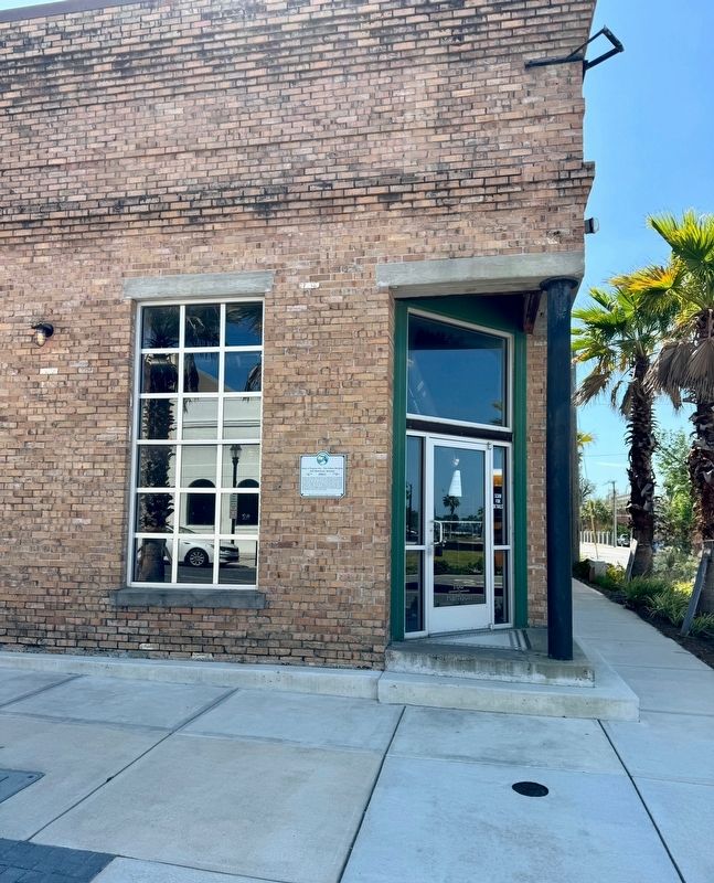
On North Center Avenue at East 4th Street, on the left when traveling south on North Center Avenue.
Built in 1925 by A.L. Barber and wife Bonnie E. Dykes. It was owned and occupied by Clara M. Dykes and husband Donald E. Emanuel after 1925. It still remains in the ownership of the Emanuel family descendants. Both the Dykes and the Emanuel families . . . — — Map (db m245382) HM
On West Beach Drive west of Flower Avenue, on the right when traveling west.
John Clark, Governor of Georgia from 1819 to 1823, built and lived in a lodge-style home on this site in 1827. He and his family died of yellow fever in 1832 and were buried on the property. In 1923, the headstones and remains were returned to . . . — — Map (db m245737) HM
On West 16th Street at Drummond Avenue, on the right when traveling west on West 16th Street.
This building was originally constructed on Brackin's Wharf, located at the south end of Drummond Avenue and was used as a warehouse and fish house. The building was moved to the present site in 1917 and used as a residence to this day. — — Map (db m245515) HM
On Moore Circle north of West Beach Drive (Florida Route 30), on the left when traveling north.
A charming bungalow built by H. W. Johnson for his family. The property was a wedding gift to Johnson's first bride from his uncle, G. B. Thompson. From 1910 to 1924 Monte and Lillie Pickens, founder of St. Andrews Conservatory of Music and Oratory . . . — — Map (db m245635) HM
On North Church Avenue at East 2nd Street, on the right when traveling north on North Church Avenue.
This house was built as a “replacement Home” in 1918 when Lewis S. & wife Jane Holmes Anderson left the “Holmes homestead on the peninsula “ along with Mrs. Wesley Holmes to make way for the new "Sherman Shipyard", to be built. It would be "home" to . . . — — Map (db m245632) HM
On West 9th Street (Business U.S. 98) east of Chestnut Avenue, on the right when traveling east.
After the Lynn Haven Hotel burned in 1929, one of the hotel’s cottages was moved by barge to this site, and pulled on rollers by mule to its place as the west wing of the home. In 1934, the east wing of the home was completed. This home is for . . . — — Map (db m245521) HM
On East 2nd Court east of East Beach Drive, on the right when traveling east.
This house was built 1910 by Henry S. Harmon and sold to his kinsman John Marlin Sessions in 1913. Both men were experienced sawmill men who worked the nearby lumber on Massalina Bayou to provide materials for much needed new houses in the brand-new . . . — — Map (db m245232) HM
On Harrison Avenue south of West 6th Street, on the right when traveling south.
This building was built between 1926 and 1933 by W.L. Folkes. It was previously known as the Panama City Milk and Cream Company and in 1935 as Bayhead Dairies, the largest and most complete dairy products organization in the community at that time. . . . — — Map (db m245351) HM
On Harmon Avenue at East 1st Court, on the left when traveling north on Harmon Avenue.
Built on an Indian midden in 1912 by W.A. and Sylvia Kelly as a bungalow cottage, this home was purchased in 1948 by Brown and Estelle Howell, who remodeled in 1952 and turned it into a ranch style house. The Howells changed the entrance from First . . . — — Map (db m245229) HM
On Harmon Avenue at Cherry Street, on the right when traveling north on Harmon Avenue.
Leon DeVoe "Voe" and Kate Harmon built this home in 1908 on family land that was purchased in 1876 and would later become known as the Harmon Plat.
L.D. "Voe" was a mill superintendent, Panama City town councilman, and a licensed real estate . . . — — Map (db m245182) HM
On East Beach Drive at East First Court, on the left when traveling east on East Beach Drive.
This cottage style home was built on an Indian midden by early business developer George H. McKenzie and his wife Frances. It was purchased in 1928 by Professor Monte Pickens, a renowned musician. It remained in the Pickens family until . . . — — Map (db m245173) HM
On East 3rd Street east of Sherman Avenue, on the left when traveling east.
Charles and Eunice Cotton moved to Millville in 1909 and opened a 'General Merchandise Store" in this building and operated it successfully for the next six years. In 1915, he sold out his interests to the Brigman family. It became "Brigman & Co.". . . . — — Map (db m245355) HM
On East Third Street west of North Center Avenue, on the right when traveling west.
Mark S. Scott & his wife, Isabelle Balkom Scott, came to Millville in late 1907 from Holmes County and built this home for their young family in 1908. Scott was the brother of Mrs. Eunice Scott Cotton and Mrs. Mary L. Forrester who also moved to . . . — — Map (db m245362) HM
On Cincinnati Avenue at West 13th Street, on the right when traveling north on Cincinnati Avenue.
In 2015, Carmichael C. Caldwell Jr. and Sonya Y. Caldwell purchased this lot at the corner of Cincinnati and 13th overlooking St. Andrews Bay.
(caption) A Partial View of The Oaks, Overlooking the Bay — — Map (db m245630) HM
On East 2nd Plaza at North Center Avenue, on the right when traveling east on East 2nd Plaza.
This lovely home was built in 1913 by M. C. Stephenson for his large family. After his death in 1916, it became home to the Wilburn F. Turner family when they moved to Millville in 1917. W. F. Turner was an early Mayor of Millville and a wonderful . . . — — Map (db m245378) HM
On College Avenue at East 3rd Street, on the left when traveling south on College Avenue.
This one and a half story frame house was built by the St. Andrews Bay Lumber Company in 1922 on the site of the "Old School Property at Millville". The school was operated from 1908 to 1917 by the Board of Public Instruction of Washington and Bay . . . — — Map (db m245457) HM
On College Avenue, 0.1 miles south of East 3rd Street, on the left when traveling south.
This frame house was built in 1922 by the St. Andrews Bay Lumber Company on the site of the original "Old School Property at Millville". The school was operated from 1908 to 1917 until a new brick school was built on East Avenue. The C.M. "Kid" . . . — — Map (db m245455) HM
On East Beach Drive, 0.1 miles east of East First Court, on the left when traveling east.
This is the oldest known existing residence in the Cove. It was built about 1867 by Wiliam & Martha Farley who brought their family to the bay from Jackson County shortly after the close of the Civil War. Farley also planted a large grove of orange . . . — — Map (db m245154) HM
On West 9th Street at Calhoun Avenue, on the right when traveling east on West 9th Street.
Early St. Andrews pioneers Thomas & Piercy Gwaltney built this house prior to 1876 and raised a family of nine children. The house originally sat one block south of this location at the SW corner of West Beach Drive, and Calhoun Avenue. In 1912 the . . . — — Map (db m245552) HM
On West 9th Street at Foster Avenue, on the left when traveling east on West 9th Street.
This house was built in 1904 by Master Boat Builder Frank E. Haight and his wife Jennie. They had purchased the property from Capt. Lambert Ware Sr. who had purchased several tracts in 1883 and platted the area as "Ware Estates". Frank was employed . . . — — Map (db m245534) HM
On Oak Avenue south of West 10th Street, on the right when traveling south.
This house was built in 1937 by Clarence Lester Jinks as a gift to his wife Dorothy. The interior finish is all wood, with each piece personally selected by Mr. Jinks. The lumber was cut at the sawmill of Jinks Lumber Company on 11th Street close to . . . — — Map (db m245418) HM
On East 4th Street at Magnolia Avenue, on the right when traveling east on East 4th Street.
In 1937, A. W. Page built this building comprised of 4 storefronts with 15 offices upstairs for $45,000. It was sold to the local Carpenter's Union for $25,000 in 1943. During WWII, over 2100 carpenters worked at Wainright Shipyard in Panama City. . . . — — Map (db m244963) HM
On 2nd Place, 0.1 miles east of East Beach Drive, on the right when traveling west.
Newkirk and Nettie Southerland purchased this property from Henry S. Harmon, the first developer of Panama City's Cove area, and built this frame vernacular cottage by 1911. The original address was 24 Olive Street later renamed E. 2nd Place. . . . — — Map (db m245157) HM
On Cincinnati Avenue, 0.1 miles West 14th Street, on the right when traveling south.
The home was built by Thomas Freeman, surveyor for The Cincinnati Company, a large landholding concern in the area. After the company declined, eventually to enter bankruptcy, Freeman sold the home in 1894. After a series of owners, the home in 1907 . . . — — Map (db m245628) HM
On Harrison Avenue, 0.2 miles south of East Beach Drive, on the right when traveling south.
In 1936, the Van Kleeck Company, a hardware store, moved into two of the units of his new building, built by Deeb Construction Company. Panama Recreation Parlor opened in the unit at 131 Harrison Avenue. The most newsworthy event that occurred here . . . — — Map (db m245136) HM
On North Cove Boulevard at East 4th Street, on the right when traveling north on North Cove Boulevard.
In 1936, real estate developer H. L. Sudduth donated this property at 350 Cove Blvd to the Woman's Club of Panama City for the location of a clubhouse. Architect James Look drew the plans and supervised construction. Cost for the modern brick . . . — — Map (db m245130) HM
1924
The midway city of Melbourne boasts the grand opening of the Melbourne Hotel. Built by developer Elton Hall.
Late 1920's to Early 1960's
Several specialty shops, a barbershop, a taxi dispatch station and drug store enjoyed bustling . . . — — Map (db m236501) HM
Many years ago these symbols were used to distinguish between the men's and women's outhouses — the star was used for the men's and the crescent moon for the women's. According to legend, over time men let their outhouses fall into disrepair and . . . — — Map (db m196133) HM
Near South Lawrence Boulevard (Florida Route 21) just south of Oriole Street.
Side 1
The Lawrence Developing Company built the three-story, 38-room Keystone Inn at a cost of $50,000. It was designed by architect, G.M. MacDonough. Hopeful that the inn would attract potential settlers and investors, the developers held a . . . — — Map (db m214312) HM
Near Tamiami Trail East (U.S. 41) west of Bass Lake Road, on the right when traveling west.
The Ochopee area was founded in 1928 as a tomato farming community and included a prosperous town of homes, packing house, and a general store with Post Office (established in 1932).
This building was originally a cattle barn and then became a . . . — — Map (db m184177) HM
Near Broadway Avenue West at Hibiscus Street West, on the right when traveling west.
The Bank received its charter in 1923 and moved into this impressive building in 1927. It was designed by William O Sparklin who was also the architect for the Court House. There were offices on the second floor.
After the Bank moved to . . . — — Map (db m213483) HM
On Center Street South at Drew Street West, on the right when traveling north on Center Street South.
The Coleman House was built in 1879 and purchased by William Coleman in 1881. The house served as a family home to the Coleman and Clark families until purchased by the town in 2000. Through the years the Coleman House served as a boarding house for . . . — — Map (db m239242) HM
On Riverside Drive just south of Willow Branch Avenue, on the right when traveling south.
Built in 1870 for Edward M. Cheney, editor and publisher of the Florida Times Union, it occupied a site near present-day Cummer Gallery of Art. Lumberman Wellington W. Cummer built a large house adjacent to the Cheney property in 1898, at which time . . . — — Map (db m209650) HM
On Central Avenue SE at 5th Street SE, on the right when traveling north on Central Avenue SE.
First Methodist Church
of Jasper
Built 1878
Placed on National Register of
Historical Places September 29, 1978
Presented by Hamilton County Historical Society — — Map (db m123253) HM
On East 7th Avenue near North 22nd Street, on the right when traveling east.
The Columbia is the oldest and largest Spanish restaurant in the United States. It was opened as a cafe for cigarmakers by Casimiro Hernandez, Sr. When he died in 1930 his son Casimiro Hernandez, Jr. then brought it to its present glory.
The . . . — — Map (db m213639) HM
On County Road 179, 0.5 miles south of State Road 2, on the right when traveling south.
In 1880, William Thomas Keith (1856-1949) homesteaded ten acres upon which this house stands. In 1886 he filed a homestead entry with the U.S. Public Land Office and in the fall of that year built this cabin that became home for himself, his wife, . . . — — Map (db m73289) HM
Near Mango Road at State Road A1A, on the left when traveling east.
The 1st house of refuge on Florida's east coast was constructed on this site which later became part of the U.S. Lifesaving Service. Houses of Refuge were built about 20 miles apart and provided a safe haven for those shipwrecked along the desolate . . . — — Map (db m112157) HM
This Property
Has Been Placed On The
National Register
Of Historic Places
By The United States
Department Of The Interior
Community Building
1935 — — Map (db m185851) HM
On 14th Avenue at 21st Street, on the right when traveling south on 14th Avenue.
Photo: Looking north at the intersection of 14th Avenue and what was then Osceola Blvd. This early photo was in the days before S.R. 60. The large building was the Simmons Building, later called the Seminole Building where the Press Journal is . . . — — Map (db m185895) HM
On 14th Avenue, 0.1 miles south of 21st Street, on the left when traveling south.
The Pueblo Arcade
Has Been Placed On The
National Register
Of Historic Places
By The United States
Department Of The Interior
March 8, 1997 — — Map (db m185822) HM
On 14th Avenue, 0.1 miles south of 21st Street, on the left when traveling south.
Theater Plaza
Has Been Placed On The
National Register
Of Historic Places
By The United States
Department Of The Interior
“Vero Theater”
April 28, 1992 — — Map (db m185845) HM
On 20th Place (State Road 60) at 11th Avenue, on the left when traveling west on 20th Place.
Vero’s first town hall building was located at the southeast corner of the original 1913 town plat, west of the Florida East Coast Railway tracks along Osceola Boulevard, later State Road 60. Designed by John Sherwood in the Spanish Mission Revival . . . — — Map (db m100029) HM
On Fort Road (State Road 69) at Bryan Street (State Road 71), on the left when traveling east on Fort Road.
The house was built in the 1830's by John A. Syfrett. It is likely the oldest residence in Jackson County. It faces Fort Road, believed to have been routed by Andrew Jackson. In 1861, it became the home of Colonel John M.F. Erwin and his wife, . . . — — Map (db m67531) HM
On Bryan Street (State Road 71) 0.3 miles south of Fort Road (State Road 69), on the left when traveling north.
This antebellum mansion was built by Hamilton Bryan as a home for his mother in 1860 on the 5200 acre plantation established by his father, Elijah Bryan. Both of these men are buried in the Greenwood Baptist Church Cemetery. It was sold by their . . . — — Map (db m67529) HM
On Bryan Street (State Road 71) 0.3 miles north of Fort Road (State Road 69), on the left when traveling north.
Built about 1840 by James Hayes, a man of vast real estate holdings. He was killed in a battle in North Georgia in 1863. The house stayed in the estate until 1885. It was owned by Ada and William Garrett, R.W. Coulette, S.V. Wall, and Hay Long Wall . . . — — Map (db m96449) HM
On Putnam Street at Madison Street, on the left when traveling east on Putnam Street.
This Marianna landmark was built by John Davis in the 1840's for his daughter, Rebecca Davis Spears. After the death of her husband, she married Dr. Theophilus West in 1859. Dr. West served as a surgeon in the Confederate Army and was with General . . . — — Map (db m67534) HM
On Green Street at Broad Street, on the right when traveling south on Green Street.
1845 Original house now rear portion of house, built by Amanda and Oliver Rostrum. In 1875, M.L. Dekle's wife Stella, purchased house and he planted the oak trees along the street. First Baptist Church was organized here in 1881. House burned in . . . — — Map (db m74201) HM
On Lafayette Street (U.S. 90) east of Russ Street, on the left when traveling east.
This two-story residence is one of Marianna's first great antebellum mansions, built by Francis R. Ely around 1840. The house was acquired in 1889 by Francis B. Carter, who later became Justice of the Supreme Court of Florida. In 1900 the house was . . . — — Map (db m67540) HM
On Jefferson Street (State Road 166) north of Broad Street, on the right when traveling north.
Built in 1840, this house was sold by Frances Towers to Isavelle, wife of Arthur Lewis, in 1847. Richard Lewis, creator of the popular patent medicine, Lewis Eye Water, was born here in 1849. In 1852-58, the owner was George Hawkins, Territorial . . . — — Map (db m67533) HM
On Jefferson Street (U.S. 73) 0.1 miles south of Lafayette Street (Road 90), on the right when traveling south. Reported missing.
The Abstract Office is the oldest business building in Marianna. Believed to have been built as his office in the 1840's by Dr. W.S. Wilson who died in 1868. Marianna's telephone exchange was established in 1801 and this building housed the Central . . . — — Map (db m74195) HM
On Lafayette Street (U.S. 90) west of Wynn Street, on the right when traveling east.
John de Roulhac and his wife, Martha Rasco, arrived in Jackson County in 1846. This house was built about that time. Their daughter, Clara, married Dr. Julius Holden here Sept. 22, 1859. Dr. Holden served in the Confederate Army. Legend says the . . . — — Map (db m74189) HM
On Lafayette Street (U.S. 90) at Russ Street, on the right when traveling west on Lafayette Street.
Built in 1895 by Joseph W. Russ, Jr., a prominent landowner and merchant. Neoclassical alterations were made in 1910, by his wife, Bettie Philips Russ. Their only child, Frances Russ Dickerson, lived here for most of her 89 years. Five generations . . . — — Map (db m74211) HM
On Caledonia Street at Clinton Street, on the right when traveling north on Caledonia Street.
The house was built in 1864 by Joseph T. Russ for his wife Mary. In 1881 it was deeded to his daughter, Luella Burke. It was sold in 1884 to Mary Hearn West. Harriet M. Hearn, mother of Mary West bought the house in 1890. In 1891 Theodore D. West . . . — — Map (db m67518) HM
On South Jefferson Street (U.S. 19) 0.5 miles north of Apalachee Parkway (U.S. 27), on the right when traveling north.
This excellent example of a "Carpenter Classic" style farmhouse was probably built c. 1836 for Burwell McBride shortly after he moved to Jefferson County from South Carolina. He was the grandfather of Margaret McBride who married Asa May, a wealthy . . . — — Map (db m126389) HM
On West Washington Street (Florida Route 10) at South Water Street, on the left when traveling west on West Washington Street.
Jefferson County High School
Erected 1852
Charter Granted in 1852 by Legislative Council
First brick school building constructed in state
Bricks made on George Taylor Plantation
Building constructed by Samuel Carroll with slave . . . — — Map (db m239585) HM
On Walnut Street at North Olive street, on the left when traveling east on Walnut Street.
This church was on the Leon Circuit, Tallahassee District, South Carolina Conference of the Methodist Episcopal Church in 1828.
Adam Wirick, a minister on the Leon Circuit, from 1828 to 1832, “located” in Monticello and his name heads the . . . — — Map (db m239560) HM
On West Main Street (U.S. 27) west of North Fletcher Avenue (State Road 51), on the right when traveling west.
Established in 1874 by John B. Whitfield, Mayo was named in honor of James M. Mayo, a colonel in the Confederate Army and father of Nathan Mayo, who served as State Commissioner of Agriculture from 1923 to 1960. Mayo became the county seat of . . . — — Map (db m132099) HM
Near Ferran Park Drive at East McDonald Avenue, on the right when traveling south.
Originally built in 1926 facing Magnolia Avenue, relocated to present site and enlarged in 1936, refurbished in 1992, placed on the National Register of Historic Places by the United States Department of the Interior, June 23, 1994. — — Map (db m166230) HM
Near Northshore Drive, 0.1 miles west of North Bay Street (Florida Route 19) when traveling west.
Completed in 1911, this large neo-classical house is constructed of Florida cypress. Originally home to Guilford D. Clifford, one of the town’s earliest settlers and businessmen, this is now headquarters of the Eustis Historical Museum and . . . — — Map (db m166241) HM
Near North Bay Street (Florida Route 19) at West Clifford Avenue, on the right when traveling south.
The Alice B. McClelland Memorial Band Shell in Ferran Park was built in 1926 by William S. McClelland in memory of his wife. One of two historic Florida band shells still standing, it was restored in 1992 and named to the National Register of . . . — — Map (db m166235) HM
Near North Center Street just south of East Clifford Avenue, on the right when traveling north.
This property has been placed on the National Register of Historic Places by the United States Department of the Interior August 5, 1991 — — Map (db m166527) HM
Lakeside Inn Est. 1883
was placed on the
National Register
of Historic Places
by the United States
Department of the Interior
on March 19, 1987 — — Map (db m145381) HM
On Alexander Street south of West 5th Street, on the left when traveling south.
The area received its first post office in 1880. Ross C. Tremarin was appointed as the first postmaster and named the lakeside outpost “Royellou” after his three children, Roy, Ella and Louis. Two years later, the town’s official name . . . — — Map (db m145363) HM
On North Baker Street at East 6th Avenue, on the left when traveling south on North Baker Street.
After a fire destroyed the community’s Town Hall in 1922, Mount Dora was in need of an auditorium for public assemblies. Despite the hard economic times, construction of the Mount Dora Community Building began in 1929 with funds raised by the . . . — — Map (db m145589) HM
On 27908 Virgil Hawkins Circle, 0.1 miles south of North Quarters Raod, on the right when traveling south.
Julius Rosenwald was the chairman of Sears Roebuck and Co. in 1908. As a Jewish American, he believed the most serious problem of the United Stats was the plight of Black Americans. Rosenwald was a close friend of Booker T. Washington. . . . — — Map (db m185785) HM
On Captiva Drive, 0.1 miles north of Paige Court, on the right when traveling north.
'Tween Waters Inn was established on Captiva Island by F. Bowman and Grace B. Price in 1931. They started the inn with a single building and expanded it over the next 30 years, adding guest cottages, a marina, and other buildings as they built their . . . — — Map (db m94924) HM
Near McGregor Boulevard (State Road 867) south of Larchmont Avenue, on the right when traveling south.
Edison’s plan of a “Floridian bower in the lowlands of the peninsular Eden, with that charmed zone of beauty” was realized as he completed the Seminole Lodge Estate.
By the fall of 1885 designs were completed and materials for . . . — — Map (db m89863) HM
Near McGregor Boulevard south of Larchmont Avenue, on the right when traveling south.
Entry in Seminole Lodge Guest Book
—Harrie Monkhouse, Guest
March 21-April 3, 1916
Have you ever dreamed a dream of Heaven?
Where the Garden of Eden grows?
Well, come down with me to the Florida Coast
Where the Caloosahatchee . . . — — Map (db m90284) HM
On South Monroe Street (U.S. 27) at Apalachee Parkway (U.S. 27), on the right when traveling south on South Monroe Street. Reported missing.
The Capitol site was selected before Tallahassee was founded. Three log buildings housed the government in 1824. A wing of the permanent Capitol, financed by sale of city lots, was built in 1826 but was later torn down. Another building was . . . — — Map (db m129813) HM
On Monroe Street at E. Pensacola Street on Monroe Street.
The first two sessions of the territorial legislature were held at St. Augustine and Pensacola. The hazards of traveling between cities 400 miles apart prompted legislators in 1824 to locate a new capital at Tallahassee, between the two cities. Log . . . — — Map (db m100792) HM
On South Monroe Street (State Road 20) at East College Avenue, on the right when traveling north on South Monroe Street.
In recognition of its historic significance is listed in
The National Register of Historic Places
The Building, when constructed in 1927, was at the forefront of the business community with such prominent tenants as LeRoy Collins (Governor of . . . — — Map (db m131850) HM
On East Jefferson Street at South Meridian Street, on the right when traveling east on East Jefferson Street.
John Gilmore Riley was born in 1857, the son of Sarah and James Riley. He was not formally educated, but was instructed by his Aunt Henrietta. Riley became principal of Lincoln Academy, Tallahassee’s first local high school for African Americans in . . . — — Map (db m79583) HM
On North Calhoun Street, 0.1 miles south of East Carolina Street, on the right when traveling south.
Side 1
Governor William Dunnington Bloxham House 1844
This Federal-style building was constructed in 1844 by Richard A. Shine, a prominent builder and mason who constructed the south wing of Florida's Capitol in 1845. In 1881, . . . — — Map (db m79566) HM
On Rankin Avenue at Museum Road, on the right when traveling south on Rankin Avenue.
Former home of Catherine Daingerfield Willis, great-grandniece of George Washington and widow of Achille Murat, Prince of Naples and nephew of Napoleon. During the Second French Empire she was recognized as a princess and financially assisted by . . . — — Map (db m79560) HM
On South Adams Street (State Road 363) at Palmer Avenue, on the right when traveling south on South Adams Street.
Founded in 1887 as the State Normal College for Colored Students, Florida Agricultural and Mechanical University (FAMU) is the only historically state supported educational facility for African Americans in Florida. It has always been . . . — — Map (db m79571) HM
On Northeast Marion Street at Northeast Range Avenue, on the right when traveling west on Northeast Marion Street.
This late Victorian mansion was built c. 1880 for Major William H. Dial (1830-1905), a Confederate veteran of the Civil War. Dial was a surveyor who moved from South Carolina to Madison, Florida in the 1850s. This house is one of the finest examples . . . — — Map (db m102441) HM
On West Pinckney Street at South Orange Street, on the right when traveling west on West Pinckney Street.
This structure represents an adaptation of the Queen Anne style of architecture to local ecclesiastical needs and traditional building materials. Both the stimulus for constructing a new sanctuary and the idea for its basic design are attributed to . . . — — Map (db m17726) HM
On Lakeshore Drive at Priest Street, on the right when traveling west on Lakeshore Drive.
Established at Columbus, February 17, 1842, moved across the Suwannee to serve a Sawmill Complex, 1867, the office became Ellaville, 1872. Some postmasters were George F. Drew, 1867-1883, Robert L. Millinor, 1893-1912, Frederick Stroud, 1914-1922, . . . — — Map (db m67606) HM
On Southwest Rutledge Street at Southwest Range Avenue, on the right when traveling west on Southwest Rutledge Street.
Built in 1892 by William Turner (W.T.) Davis, this building is one of the few remaining buildings in Florida covered with a galvanized sheet metal facade, in this example produced by the Mesker Brothers Iron Works of St. Louis, Missouri. This use of . . . — — Map (db m96934) HM
Near Pine Avenue, 0.1 miles north of Crescent Drive.
Early Islanders relied on small boats to bring supplies and to transport visitors. As more people discovered the island, a new transportation solution was needed. In 1911, developers built a 776-foot-long pier to accommodate larger boats and to . . . — — Map (db m241304) HM
Manatee County's first Courthouse was built in 1859-1860, and is the oldest remaining building constructed as a county courthouse in the State of Florida. It was built on the original Courthouse Square at 15th Street East and Fourth Avenue, two . . . — — Map (db m43101) HM
On 4th Avenue East west of 14th Street East, on the left when traveling west.
Mary Amelia Curry House
circa 1860
This house was placed on the
National Register
of Historic Places
by the United States
Department of the Interior
September 8, 2015 — — Map (db m218515) HM
Near Manatee Avenue East (State Road 64) at 14th Street East.
A prime example of the “Cracker Gothic” style, this home was built in 1912 by the Will Stephens family. It is an excellent representation of a Florida rural frame house during the period between the 1870's and World War I. This third . . . — — Map (db m43106) HM
On Manatee Avenue East at 9th Street East, on the right when traveling west on Manatee Avenue East.
Side A The Town of Manatee was officially chartered on June 19, 1903. This intersection of Central Street (present day 9th Street East) and Manatee Avenue became the heart of the town’s business district after the arrival of the Florida West . . . — — Map (db m32409) HM
On 4th Avenue East west of 14th Street East, on the right when traveling west.
Theodosia Curry Lloyd House
1925
This house was placed on the
National Register
of Historic Places
by the United States
Department of the Interior
September 8, 2015 — — Map (db m218517) HM
Near Manatee Avenue East (State Road 64) at 14th Street East.
The Manatee Village Historical Park was created as a gift to the people of Manatee County by the Historical Commission and the HOME Committee in remembrance of our Nation's Two Hundredth Birthday in the year 1976. Two historical buildings, Manatee . . . — — Map (db m43100) HM
On Wauchula Rd at Keenetown Rd, on the left when traveling west on Wauchula Rd.
This five-room school was built in 1930 by volunteer labor when three smaller rural schools, Albritton, Bunker Hill, and Duette were consolidated. It is the only one-teacher school remaining in the state of Florida. For many years, it was a . . . — — Map (db m25060) HM
Near 10th Avenue West at 6th Street West, on the right when traveling south.
Building Palmetto’s Carnegie Library, the first real library in Manatee County was a collaboration: Andrew Carnegie’s foundation contributed $10,000, the City supplied $1000 and the land, and the Ladies’ Library Association provided all the . . . — — Map (db m146785) HM
Near 10th Avenue West at 6th Street West, on the right when traveling south.
The Cyprus House Military Museum opened the public on July 3, 2004, and is the most recent addition to the Palmetto Historical Park. This structure was originally located on Longboat Key in the mid 30’s and was one of the several cypress cottages . . . — — Map (db m146749) HM
Near 10th Avenue West at 6th Street West, on the right when traveling south.
Heritage Chapel is the only building in the Palmetto Historical Park that is not historic. After searching for an original chapel, it was decided in 1999 to construct a new building approximately the standard size of the original churches in . . . — — Map (db m146751) HM
388 entries matched your criteria. The first 100 are listed above. Next 100 ⊳