After filtering for South Dakota, 79 entries match your criteria.
Exploration Topic
November 26, 2022
Springfield Marker
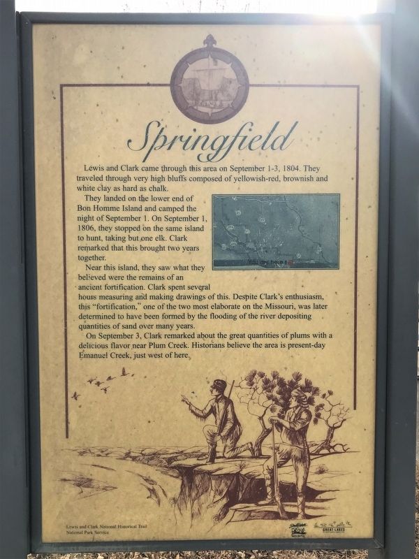
| 1 ► South Dakota, Bon Homme County, Springfield — Lewis and Clark / Springfield — Lewis and Clark National Historical Trail — |
| 2 ► South Dakota, Brookings County, Bruce, Oakwood Township — 14 — Muskrat — Station 14 — Tetonkaha Trail — |
| 3 ► South Dakota, Brule County, Chamberlain — 456 — Lewis & Clark Memorial Bridge at Chamberlain — |
| 4 ► South Dakota, Brule County, Chamberlain — Lewis and Clark Bicentennial 1804-2004 — |
| 5 ► South Dakota, Brule County, Chamberlain — 114 — Sojourn at Camp Pleasant — Lewis & Clark Expedition — |
| 6 ► South Dakota, Brule County, Chamberlain, Chamberlain Township — The Missouri River — Chamberlain and the Lewis & Clark Expedition — |
| 7 ► South Dakota, Brule County, Chamberlain, Chamberlain Township — The Plant Life — Chamberlain and the Lewis & Clark Expedition — |
| 8 ► South Dakota, Butte County, Belle Fourche — Belle Fourche — "Beautiful Fork" — |
| 9 ► South Dakota, Campbell County, Pollock — Lewis and Clark and the Legend of Stone Idol Creek/Lewis and Clark Expedition Meet The Arikara — |
| 10 ► South Dakota, Campbell County, Pollock — Lewis and Clark/Pollock, South Dakota — |
| 11 ► South Dakota, Charles Mix County, Pickstown — Pickstown / Lewis and Clark — Lewis and Clark National Historical Trail — |
| 12 ► South Dakota, Charles Mix County, Pickstown, White Swan Township — Fort Randall Area — |
| 13 ► South Dakota, Clay County, Vermillion — Confluence of the Vermillion and Missouri Rivers — |
| 14 ► South Dakota, Clay County, Vermillion — Lewis and Clark / Vermillion — Lewis and Clark National Historical Trail — |
| 15 ► South Dakota, Clay County, Vermillion — Lewis and Clark Visit Spirit Mound — August 25, 1804 — |
| 16 ► South Dakota, Clay County, Vermillion — Lewis and Clark Were Here...and Here... — |
| 17 ► South Dakota, Clay County, Vermillion — Spirit Mound — |
| 18 ► South Dakota, Clay County, Vermillion — 413 — Vermillion / Historic Highway — |
| 19 ► South Dakota, Clay County, Vermillion — Welcome to Cotton Park — Missouri National Recreational River Water Trail — |
| 20 ► South Dakota, Clay County, Vermillion, Spirit Mound Township — Hill of Chalk — Missouri National Recreational River — |
| 21 ► South Dakota, Clay County, Vermillion, Spirit Mound Township — Hill of Little Spirits — Missouri National Recreational River — |
| 22 ► South Dakota, Clay County, Vermillion, Spirit Mound Township — Spirit Mound Monument — |
| 23 ► South Dakota, Corson County, Mobridge — 380 — Jedediah Smith — 1799-1831 — |
| 24 ► South Dakota, Corson County, Mobridge — 622 — Sakakawea — |
| 25 ► South Dakota, Custer County, Buffalo Gap — 469 — Jedediah Strong Smith’s Route - - 1823 — |
| 26 ► South Dakota, Custer County, Custer — An Agreement Between Cultures — The Fort Laramie Treaty Created the Great Sioux Reservation — |
| 27 ► South Dakota, Custer County, Custer — An Expedition of Mixed Outcomes — The Custer Expedition of 1874 Ignited Interest in the Black Hills — |
| 28 ► South Dakota, Custer County, Custer — 448 — Campsite of General Custer's Expedition — August 1 - 6, 1874 — |
| 29 ► South Dakota, Custer County, Custer — Everything changes, or does it? — |
| 30 ► South Dakota, Custer County, Custer — 604 — Horace N. Ross — |
| 31 ► South Dakota, Custer County, Custer — Prospectors in Search of Gold — The Gordon Party Prompted an Illegal Invasion of the Black Hills — |
| 32 ► South Dakota, Custer County, Custer, West Custer Township — Landscapes & Logging — Black Hills National Forest — Caring for the Land and Serving People — |
| 33 ► South Dakota, Gregory County, Pickstown — Welcome to Randall Creek Recreation Area — Missouri National Recreational River Water Trail — |
| 34 ► South Dakota, Hughes County, Pierre — A Changing Landscape — |
| 35 ► South Dakota, Hughes County, Pierre — A Tense Three Days — |
| 36 ► South Dakota, Hughes County, Pierre — Entering Teton Country — Lewis & Clark Expedition — |
| 37 ► South Dakota, Hughes County, Pierre — Lewis & Clark Trail — Griffin Park — |
| 38 ► South Dakota, Hughes County, Pierre — Lewis and Clark — |
| 39 ► South Dakota, Hughes County, Pierre — Pierre — |
| 40 ► South Dakota, Hughes County, Pierre — The Lewis and Clark Expedition — |
| 41 ► South Dakota, Hughes County, Pierre, Raber Township — 40 — First Permanent Fur Post — |
| 42 ► South Dakota, Lawrence County, Deadwood — Gold Discovery in the Great Sioux Reservation — |
| 43 ► South Dakota, Lawrence County, Spearfish — Thoen Stone — |
| 44 ► South Dakota, Lawrence County, Spearfish — 22 — Thoen Stone — Historic Marker — |
| 45 ► South Dakota, Lyman County, Reliance — 188 — Historic Highway — |
| 46 ► South Dakota, Meade County, Mud Butte — 639 — Ben Ash — |
| 47 ► South Dakota, Meade County, Sturgis — Dr. F. V. Hayden — |
| 48 ► South Dakota, Minnehaha County, Sioux Falls — Namesake of the City — |
| 49 ► South Dakota, Perkins County, Seim, DeWitt Township in Shadehill State Recreation Area — Hugh Glass — 1828-1928 — Reported permanently removed |
| 50 ► South Dakota, Perkins County, Shadehill — Hugh Glass — |
| 51 ► South Dakota, Potter County, Gettysburg — 438 — Original Site Medicine Rock — 2.6 miles — |
| 52 ► South Dakota, Stanley County, Fort Pierre — Fort Pierre Chouteau — National Historic Landmark — 1832-1857 — |
| 53 ► South Dakota, Stanley County, Fort Pierre — Lewis and Clark / Fort Pierre, South Dakota — |
| 54 ► South Dakota, Stanley County, Fort Pierre — Lewis and Clark Encounter Teton Sioux — |
| 55 ► South Dakota, Stanley County, Fort Pierre — Lewis and Clark First Sioux Nation Meeting — |
| 56 ► South Dakota, Stanley County, Fort Pierre — The Lewis and Clark Expedition — |
| 57 ► South Dakota, Stanley County, Fort Pierre — The Verendrye Site — |
| 58 ► South Dakota, Stanley County, Fort Pierre — Translation of the Verendrye Plate — |
| 59 ► South Dakota, Stanley County, Fort Pierre — Verendrye Explorers — |
| 60 ► South Dakota, Stanley County, Fort Pierre — Verendrye Site — National Historic Landmark — |
| 61 ► South Dakota, Stanley County, Fort Pierre — 49 — Verendrye Tablet Site — |
| 62 ► South Dakota, Union County, Elk Point — A Land of Plenty — |
| 63 ► South Dakota, Union County, Elk Point — 405 — Elk Point — |
| 64 ► South Dakota, Union County, Elk Point — Entering an Uncertain Land — |
| 65 ► South Dakota, Union County, Elk Point — 407 — First Election in Northwestern United States — |
| 66 ► South Dakota, Union County, Elk Point — Lewis & Clark Campsite / Eli Wixson Farm Site — |
| 67 ► South Dakota, Union County, Elk Point — Return to "Elk Sign" Campsite — |
| 68 ► South Dakota, Union County, Elk Point — The Lewis and Clark Expedition — |
| 69 ► South Dakota, Union County, Elk Point — U.S. Democracy Crosses the Mississippi River — |
| 70 ► South Dakota, Walworth County, Mobridge — "Sakakawea and Lewis & Clark" — |
| 71 ► South Dakota, Walworth County, Mobridge — "the track of the white bear" — |
| 72 ► South Dakota, Walworth County, Mobridge — A Valuable Member of the Team — |
| 73 ► South Dakota, Walworth County, Mobridge — History Beneath the Waters — |
| 74 ► South Dakota, Walworth County, Mobridge — Lewis & Clark — |
| 75 ► South Dakota, Walworth County, Mobridge — Lewis & Clark meet the Arikaras — |
| 76 ► South Dakota, Walworth County, Mobridge — Lewis and Clark Expedition — |
| 77 ► South Dakota, Walworth County, Mobridge — Lewis and Clark/Mobridge — |
| 78 ► South Dakota, Walworth County, Mobridge — River of Hardship — |
| 79 ► South Dakota, Yankton County, Yankton — The Lewis & Clark Expedition — |