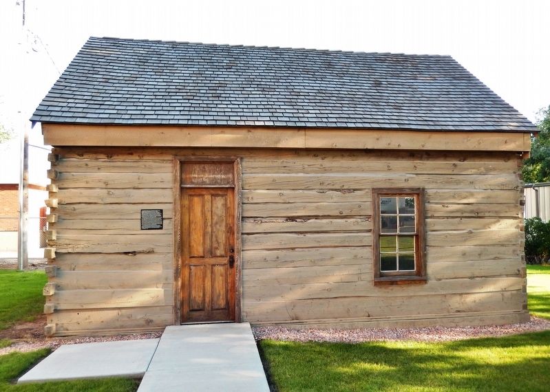
This early sawed log farm cabin (circa 1890-1900) was relocated to this site from the small hamlet of Manderfield located 5 miles north of Beaver. Manderfield was known as Indian Creek in pioneer days. The Beaver Chapter of the sons of The Utah . . . — — Map (db m127201) HM
In 1872-73 a two and two-thirds mile square, protective military reservation was established following the request of C.M. Hawley, Associate Justice, Utah Territory. Built of native rock and lumber, it received 250 troops Sept. 7, 1873, Major John . . . — — Map (db m75578) HM
In 1942, Bushnell General Hospital was built in Brigham City by the federal government to treat World War II wounded. The hospital closed in 1946 after 13,000 army personnel were treated there.
In 1950, the Bureau of Indian Affairs coverted . . . — — Map (db m240490) HM
On this site the Corinne Opera House, for many years the largest recreation center in Utah outside of Salt Lake City, was erected in 1879. Built of red pine lumber with square nails, the leading stock companies, California bound on the new railroad, . . . — — Map (db m105258) HM
Three Mile Creek, later named Perry, originated in 1853 with the arrival in the Three Mile Creek Valley of the William Plummer Tippetts family and Lorenzo and May Perry. They were soon joined by William Walker, Thomas C. Young, Alex Perry, and . . . — — Map (db m240481) HM
When the Willard Central School was constructed in 1902, a bell tower with a large brass bell was installed on the roof toward the front of the building. The bell was rung fifteen minutes before school began and again at noon. Students vied for . . . — — Map (db m240487) HM
Erected in 1861 by Hezekiah Thatcher, assisted by Robert Crookston, Robert Murdock and John Hill, who quarried the building stones in Green Canyon and place them in these walls, hand made shingles covered the roof, the building was originally used . . . — — Map (db m44436) HM
Thirty feet east of this spot was built, in the winter of 1865-1866, under the leadership of Benget P. Woolfenstein, the first community center of the Logan Fifth Ward. Consisting of but one room, 16 by 20 feet. It served, nevertheless, as church . . . — — Map (db m154443) HM
Utah State University’s football field at Romney Stadium as named the Merlin Olsen Field at Romney Stadium on December 5, 2009 by President Stan L. Albrecht.
The statue was unveiled on October 23, 2010. In attendance were many of Merlin and . . . — — Map (db m44455) HM
The Whittier School, constructed in 1908, is important for its association with the education reform following Utah’s statehood. These reforms included a statewide curriculum and the construction of numerous unified schoolhouses. The Whittier School . . . — — Map (db m108847) HM
Harding School was named after President Warren G. Harding. Classes started August
1925 with George Fox as the first principal.
It was used as an elementary school until May 1968 when Principal James L. Jensen
called classes to order for the . . . — — Map (db m101032) HM
BLISS HALL was erected in 1872 by the New West Education Commission of the Congregational Church for Protestant Missionary Schools. It was named for Charles R. Bliss, a New England minister, and the hall served both as church and school. No . . . — — Map (db m245970) HM
A close look around this area will reveal what remains of the foundation of the Frary's little home. This modest home was the center of life
for the family. Because of their remote island location, this is where the children
received their . . . — — Map (db m172634) HM
Early settlers knew the importance of education. In 1885, a one-room
schoolhouse was constructed on this site, and all 8 grades met together.
Textbooks were scarce, but the students learned reading, writing,
and arithmetic. Unfortunately, most . . . — — Map (db m243441) HM
In 1908 the townsite of Elmo was laid out. Each summer a bowery was erected east of
this site where social events were held. In 1911 a group of men purchased the Cleveland
schoolhouse, dragged it with teams and logs to the bowery lot. It was . . . — — Map (db m147941) HM
The Presbyterian church entered Utah Territory and expanded rapidly between 1869 and 1883. Around 1911, they erected this building as the Ferron Wasatch Academy, one of forty such institutions in Utah.
These private educational systems led to the . . . — — Map (db m147843) HM
Established as Huntington High School in 1915 with Robert L. Fenton as Principal. In December 1916 the school moved into a new building on the east side of Main street at 100 North. The first senior class consisting of eight girls and two boys . . . — — Map (db m147924) HM
In 1883 the men and boys of this community brought material from the mountains and built a hall on this spot of ground. They formed a company and rented the hall. The L.D.S. Church purchased the building when Jasper N. Robertson was first Bishop. It . . . — — Map (db m147918) HM
In 1904 the Hatch L.D.S. Ward building was erected on this lot. A vestibule was added in 1910 and the bell was purchased with donations from ward members. For many years it hung in the tower and rang out for all civic, social and church activities. . . . — — Map (db m74679) HM
Star Hall is the oldest public building in Moab that is still in use. Listed on the National Register of Historic Places, it was constructed in 1905-1906 by the local Mormon community to serve as a social and cultural center.
The exterior of the . . . — — Map (db m160044) HM
Born in England, Francis Webster traveled to Utah in 1856 and played an important role in the early development of Cedar City. A leader in the sheep industry, he was among the first to begin shipping sheep and wool to the Chicago markets. An early . . . — — Map (db m75620) HM
There are five plaques across the base of the statue
In the annals of American higher education, there is no more dramatic founding of a school than that accorded Southern Utah University, nor a more striking example of the extent of the . . . — — Map (db m59516) HM
Site of Church of Jesus Christ of Latter-day Saints recreation building known as the Ward Hall. Rushed to completion in the fall of 1897 and deeded to the State of Utah so the Branch Normal School of the University of Utah could be legally . . . — — Map (db m59543) HM
In memory of our Mona School and the dedicated teachers, board members, custodians, students and citizens who made it great; we have built this monument from sandstone and brick recovered therefrom. The bell hereon, signaled the beginning of school . . . — — Map (db m75280) HM
The Kanab Library was built between 1939 and 1940 as a Works Progress Administration (WPA) project. The library is one of 226 buildings constructed in Utah under the WPA and is important in documenting the impact of New Deal programs in the . . . — — Map (db m94940) HM
Soon after pioneers founded the town of Kanab, they established school for both young and old. At first, school was held in the Kanab fort, but it soon became inadequate to meet the needs of the growing community. Then, a two-story brick school . . . — — Map (db m94947) HM
For the people of Kanab, this bell represents schools and the importance of learning. From its founding in 1870, Kanab citizens have been encouraged to obtain as much education as possible and to use it for the benefit of all. For the first two . . . — — Map (db m41304) HM
For the people of Kanab, this bell represents schools and the importance of learning. From its founding in 1870, Kanab citizens have been encouraged to obtain as much education as possible and to use it for the benefit of all. For the first two . . . — — Map (db m94986) HM
In 1886-1887 after the United Order terminated, a public building was erected of native limestone and lumber from the canyon sawmill. It was used for school and church purposes. In 1938 a new schoolhouse was built and the Old Rock Building given to . . . — — Map (db m74642) HM
The Relief Society in Deseret was first organized in September of 1877. This group of women met in each other's homes until 1878, when they had a large, one-room adobe hall built. In 1894 the members of the Relief Society decided they should . . . — — Map (db m69541) HM
Fillmore was settled in 1851. Before the close of the first year the Pioneers had erected a log school room inside the fort. It had split logs for seats, a dirt roof and floor. In 1854 an adobe church was built which also served as school. In 1867 . . . — — Map (db m69581) HM
Built 1909 - 1910 of brick
Architect: S.T. Whicker
Construction Supervisor:
T. George Theobold
Millard LDS Academy
1910-1923
Hinckley High School
1923-1953 — — Map (db m69538) HM
The South Butlerville School was build about 1892 at 2235 East on the north side of Creek Road (8200 South). The school was built of brick, and the foundation was granite rock. Using a team of horses and a wagon, David Alma Proctor hauled the rock . . . — — Map (db m123646) HM
Built in 1912, the architect was Niels Edward Liljenberg. This building replaced a school that was built on this same site in 1883. The school was named in honor of John R. Park, a leading educator in Utah, a former teacher and principal in Draper, . . . — — Map (db m224393) HM
Designed by school district architect Niels Edward Liljenberg, the Draper Park School was constructed in 1912, replacing an 1883 school on this same site. The building was named in honor of Dr. John R. Park, a leading figure in Utah’s educational . . . — — Map (db m224391) HM
On the present site of Draper Historic Park, with some expansion to the north and south, stood Draperville Fort. Fort Street was named for this historic enclosure.
According to the Eleventh General Epistle of the Presidency of The Church of . . . — — Map (db m224741) HM
The Old White Meetinghouse
In 1852, on the north wall of Draper Fort, a one-room adobe school building was erected to serve as a gathering place for the early settlement.
In 1860 a second public structure was built. This second structure . . . — — Map (db m231211) HM
John and Elisabeth Enniss joined the Church of Jesus Christ of Latter-day Saints along with hundreds of other members of the United Brethren in Herefordshire, England in the early 1840s. Their conversion sparked a natural desire to emigrate to Utah. . . . — — Map (db m231212) HM
The north wall of the "Old Meeting House" stood near this monument. Here (1861-1869) Dr. John R. Park began his career as an educator in Utah. This school produced many of the state’s leaders and left an indelible love for education in Draper. . . . — — Map (db m224607) HM
Heber A. Smith built this brick building circa 1890-1895 which served as one of the first three school houses in Draper, having one large room upstairs and two in the basement. Later is was used as a pool hall known as Poolies. In 1923 E. Miller . . . — — Map (db m224398) HM
Built circa 1900. This house was owned at one time by the Jordan School District and was home to Reid Beck, who was the principal of Draper Elementary and Junior High School from 1917, until his death in 1943. Mr. Beck and his wife purchased the . . . — — Map (db m224399) HM
In April 1, 1894, the St. Mark’s Hospital Board of Directors authorized the establishment of the first Official Nurses Training School in the Intermountain Region. Mary Edith Newitt was employed as Superintendant of the Training School.
The . . . — — Map (db m1430) HM
The mansion, completed in 1901, was designed for Alfred W. and Elizabeth McCune by architect S. C. Dallas. Alfred McCune acquired great wealth through railroad, mining, and timber enterprises. In 1920, after the McCune's moved to Los Angeles, they . . . — — Map (db m132485) HM
The parent school or the University of Deseret, established November 11, 1850 in the home of John Pack, was located on this corner. Forty students enrolled the first year. Produce, lumber, etc. were taken for tuition and sold by Mr. Pack. Cyrus W. . . . — — Map (db m223394) HM
Near this spot once stood a wall built of
stone from Red Butte Canyon. Decision to thus
enclose University of Deseret now University
of Utah campus was made, March 13, 1850, same
day present site recommended by Brigham Young
and committee . . . — — Map (db m239748) HM
In June 1875 in answer to the appeal of the Rev. Lawrence Scanlan, two Sisters of the Holy Cross, Mother M. Augusta and Sister M. Raymond, came to Salt Lake City. In August they were joined by Sisters M. Pauline, Anna, Josepha, Holy Innocents, and . . . — — Map (db m149966) HM
On this site John Morgan, noted Civil War Veteran, Educator, L.D.S. Missionary and Church Leader, established the first successful educational institution in the Territory of Utah.
Here was established the Morgan College in 1870, Utah’s first . . . — — Map (db m152852) HM
The Oregon Shortline Railroad Company built the lower, eastern section of this building to house its offices in 1897. Shortly therafter, the Salt Lake City School Board contracted with the railroad to build the small annex and larger, more elaborate . . . — — Map (db m35714) HM
Built by Brigham Young for his own children stood on this corner lot 1860-1903 This early school was directed by Eli B. Kelsey, who in soliciting additional students announced in the Deseret News, December 12, 1860, as follows:
. . . — — Map (db m35005) HM
The Eagle Gate marked the entrance to the homes of Brigham Young. During the early settlement of the valley, Brigham Young was aloted the land lying athwart the mouth of City Creek Canyon. His New England heritage prompted him to desire the privacy . . . — — Map (db m35161) HM
Richard Kletting, an immigrant born July 1, 1858 in Wurttemburg, Germany. Kletting was trained in engineering and architectural technology in Germany and France, where he worked on notable buildings, such as the Bon Marche and Sacred Coeur at . . . — — Map (db m245949) HM
On this site in 1857, the Twentieth Ward or Twentieth District School was erected, John Toone builder. The one large room served for school, church and recreation. In 1860 a two-story addition was constructed. Pupils came from all parts of Salt Lake . . . — — Map (db m43559) HM
National Register
U of U Circle Historic District
David P. Gardner Hall
This Neoclassical stone building, constructed 1930-31, originally served university students as their Union Building. It was paid for with student fees and was . . . — — Map (db m240557) HM
This gathering place for students, faculty and the community pays tribute to educator and philanthropist Emma Eccles Jones (1898-1991), whose landmark contributions - made in loving memory of her father during the last year of her own life - . . . — — Map (db m239567) HM
Restored and renovated through the generosity of the
George S. and Dolores Dore Eccles Foundation
First constructed at Fort Douglas in 1875 using native red sandstone from the nearby quarry in Red Butte Canyon, this building originally . . . — — Map (db m225327) HM
Restored and renovated through the generosity of the
George S. and Dolores Dore Eccles Foundation
First constructed in 1825 as Fort Douglas Post Headquarters, this historic structure built of Red Butte sandstone was converted into an . . . — — Map (db m225323) HM
Built of red sandstone from the mountains near Heber City,
this building was used for school and church meetings.
The year 1890 brought about Utah's Free School Law, but
before 1890, teachers received their salary as a result of
students' . . . — — Map (db m172174) HM
In 1875, Brigham Young established the Brigham Young
Academy with Abraham O. Smoot as president of the
Board of Trustees. This building is a replica of Lewis Hall,
where the first class of 1876, consisting of just 70 students,
were housed. . . . — — Map (db m173261) HM
Church Takes Root in Sandy
This monument recalls the early history of the Church of Jesus Christ of Latter-day Saints in the Sandy area, and the three pioneer chapels that were located across the street to the east.
A few Church . . . — — Map (db m238456) HM
In 1859, George A. Smith sold his Mexican Land Grant to Alexander Beckstead, who, with others, settled ½ mile to the south. They dug a five mile ditch from Jordan River, in operation since completed in 1863. Adobe Community House built, 1864. . . . — — Map (db m34679) HM
In the 1850’s and 1860’s, three brothers, Joseph, John, and Richard Carlisle, settled in this location between 700 West and Jordan River. Their endeavors included farming, dairying, and planting mulberry trees to raise silk worms. They developed a . . . — — Map (db m124303) HM
This eclectic Chateauesque style building was constructed in 1899 by the Roman Catholic church. It was designed by Carl M. Neuhausen, architect of the Thomas Kearns Mansion and the Cathedral of the Madeleine, both located on South Temple Street. . . . — — Map (db m35608) HM
On this site, 6200 South and Redwood Road, in the year 1905 stood the 64th District School House. It was a red brick building consisting of two large rooms on the west side and a single large room on the east side.
The name of the school was . . . — — Map (db m41348) HM
Garfield Beach Railroad Junction was built in 1905. In 1908, its post office was named Welby in honor of Rio Grande Railroad Superintendent. The R.G.R.R. Company drilled water wells, built soft water treatment plant, a round house, machine and . . . — — Map (db m35033) HM
When Joseph Harker crossed Jordan River at 3300 South in 1848, he luckily found springs. By 1870 pioneers had sparsely settled the Granger area. School was held in homes until 1882 when the 16 x 24 foot West Granger was built at 3500 South and 4000 . . . — — Map (db m231232) HM
Homesteaders and settlers came in the 1870's to the area 4700 South to 7200 West, north to the Great Salt Lake, northeast along it's shore and the Davis County line to 4800 West and south to 4700 South. This area became Hunter Precinct in 1880 from . . . — — Map (db m35101) HM
There was a large bell in the belfry of the Old Monroe School. It rang out over the valley, and unified the entire Granger community. Children came from all directions to beat its last clang. Some walked, others came in white topped horse drawn . . . — — Map (db m231237) HM
Sketched by Remington Lange 1893 Bluff's log meetinghouse was the center of all public gatherings for the small community on the remote San Juan frontier. The meetinghouse, which was part of the north wall of the Bluff Fort, served as . . . — — Map (db m149540) HM
Built in 1914-1915, the Ephraim Carnegie Library is one of 23 Carnegie Libraries in Utah and one of over 1650 library buildings in the United States that were founded by millionaire/philanthropist Andrew Carnegie. Carnegie donated the entire cost of . . . — — Map (db m74993) HM
Constructed between 1889 and 1908, this building was the first permanent home of Snow Academy which in 1923 became Snow College. The school was founded in 1888 as the Sanpete Stake Academy and was one of the eleven academies established by the . . . — — Map (db m75024) HM
Manti's Old Red Schoolhouse was located at 65 South, First West 1894-1936. Its Schoolhouse bell was forged in 1892 and was originally used in the one-room rock, North Ward Schoolhouse. Bell tower erected 1989. — — Map (db m243318) HM
Pioneer Values
Education
The Pioneers were a culturally diverse group, gathered together from many nations. Yankees, Southerners, British, and Scandinavians made up the majority of the people. Though their backgrounds varied, a universal . . . — — Map (db m243323) HM
Built in 1913-14, the Richfield Carnegie Library is one of 23 Carnegie Libraries in Utah and one of over 1650 library buildings in the United States that were built by millionaire/philanthropist Andrew Carnegie. Carnegie donated the entire cost of . . . — — Map (db m74821) HM
Erected in 1884 as a memorial to Helen Rutgers Crosby of New York City, this church and school was one of several Presbyterian churches built in central Utah's Sanpete and Sevier Valleys under the direction of Reverend Duncan McMillan, Presbyterian . . . — — Map (db m74858) HM
First public building in Summit County, built in 1865, originally used as county building, meeting house and amusement hall, later, as school house dedicated by President Brigham Young in the fall of 1868. Summit Stake was organized in this building . . . — — Map (db m67611) HM
Construction started on this second public building in 1857 and this building was dedicated by President Brigham Young in 1863. The dimensions of this structure are 21′ x 32′, with the foundation walls 28″ thick and the walls above . . . — — Map (db m224153) HM
Construction on the old red schoolhouse started in the spring of 1899 and was completed in 1901 at a cost of $3,789.12. In 1882 school trustees petitioned Alpine City to purchase the land to build the schoolhouse and paid $5.00 for it. Sand for . . . — — Map (db m224156) HM
The Territorial Legislature, February, 1866, authorized the levy of a tax for the support of schools within each district, pursuant to this act, Mayor Leonard E. Harrington called a meeting and the majority of citizens of American Fork approved . . . — — Map (db m149845) HM
This school was among the first wave of public schools built in Utah as a result of an 1880 educational reform. Local legislator Leonard Harrington, for whom the school was named, was influential in changing the educational system in Utah by . . . — — Map (db m149846) HM
This building is one of the oldest schools and community centers now standing. The west wing built about 1864, from adobes salvaged from first and second school houses of 1852-53. Planned by Henry Greenhalgh. Center and east rooms added about . . . — — Map (db m149580) HM
In October 1875, President Brigham Young executed a deed of trust to establish an academy. First classes were held in January 1876, Warren N. Dusenberry, Principal. Karl G. Maeser became Principal April 1876 to 1892. First school held on this site . . . — — Map (db m149027) HM
This block is named Brigham Young Academy Square in recognition of its vital history. In 1875, Brigham Young, then President of The Church of Jesus Christ of Latter-Day Saints, founded Brigham Young Academy in Provo, Utah. He appointed a board of . . . — — Map (db m146798) HM
August 20, 1912, the Board of Education agreed, "That a high school be established in Provo City." The so-called high school began with "one year" then "two years" and then more until it became a four year school. At the close of the school year . . . — — Map (db m149028) HM
William and Warren Dusenberry operated the Timpanogos Branch of the University of Deseret in Lewis Hall, a two-story brick building on the northeast corner of the intersection of 300 West Center. From 1870 to 1875, the school succeeded . . . — — Map (db m223694) HM
In 1906, the Junior Class of 1907 whitewashed their graduation year on the mountain east of campus. When other students saw these numbers on the mountain, a massive invasion by the Senior Class against the offenders began. The 1907 date on the . . . — — Map (db m223826) HM
This plaza is dedicated to the memory of Charles Edwin and Mary Jane Loose for their generous contribution of land on this block to the Provo School District and the students of the Maeser Elementary School. Shortly after the opening of the Maeser . . . — — Map (db m223774) HM
Formal education developed very slowly in early Provo. By 1855, only slightly more than half of Provo’s eligible students attended school. It was not until the 1860s that Presiding Bishop William Miller convinced each Provo ward to build its own . . . — — Map (db m223656) HM
In 1872 a group of young men organized a debating & public speaking society with Geo. H. Brimhall, President. They erected this building. Samuel Brockbank had charge of getting logs & construction: John F. Gay, carpenter: Nicholas Smith, timekeeper. . . . — — Map (db m148727) HM
Palmyra‘s First Amusement Hall
To the north of the little one-room schoolhouse, the people of Palmyra began building the lumber Amusement Hall on February 10, 1900. It took exactly one month to complete the building, and a dance was held in . . . — — Map (db m148720) HM
This house was built in 1906-08 by Ira E. and Marion Hinton Bradshaw, lifelong residents of southern Utah. It was the first permanent house built in the town of Hurricane, which was established soon after completion of the Hurricane Canal in 1904. . . . — — Map (db m74619) HM
In 1881 Thomas Judd, promoter, with others completed an 840 foot tunnel and 1 1/4 mile canal to bring water from the Rio Virgin for the cultivation of this valley. Excavations opened a large crystal cave of stalactite and stalagmites.
In 1903, . . . — — Map (db m59448) HM
The era of the "Great Depression" began with the crash of the stock market in 1929. The economy of the United States changed dramatically. Americans were in peril; unprecedented numbers were jobless. President Franklin D. Roosevelt took office in . . . — — Map (db m243202) HM
The building to your left was originally built as a schoolhouse in 1880 in nearby Silver Reef. It also served in the mining boomtown as a place for community dances and other gatherings.
Soon after the schoolhouse was built, Silver Reef began . . . — — Map (db m59663) HM
Schoolhouse site built 1880
Miss Carrie Walker taught up to 85 students. In the early 1900s it was moved to Leeds. It is still in use as the town hall. — — Map (db m243212) HM
Across the street west, and 2 blocks south of here, stands the building originally known as the St. George Academy. After the turn of the century Southern Utah citizens realized a great need for higher education in this isolated corner of the state. . . . — — Map (db m1392) HM
Dixie Academy was constructed to provide advanced courses of study. The St. George Stake Academy officially began in 1888 and moved into this building in 1911. A four year program was recognized as two years of senior high school and two years of . . . — — Map (db m1462) HM
When the first settlers arrived in St. George late in 1861, school was held in a wagon box, a tent, a willow shack, or whatever shelter could be improvised. By 1864, the first of four ward houses was completed. It was not until nearly the end of the . . . — — Map (db m1389) HM
With the arrival of the families in St. George, school began. A tent, slates and a few books served students in the 1st Central School. Later school was held in different private homes and public buildings until this permanent school was completed . . . — — Map (db m1390) HM
Present city officials and citizens of Washington City desired to pay tribute to early prominent pioneers who first settled here in 1857. These pioneers sacrificed their all while improving conditions in this harsh, dry, hot inhospitable, . . . — — Map (db m59315) HM
105 entries matched your criteria. The first 100 are listed above. The final 5 ⊳