The primary purpose of the California Nursery Historical Park Master Plan is to tell the story of the California Nursery Company to current and future generations through the sharing of the site’s remaining historic buildings, majestic . . . — — Map (db m208557) HM
For many years the California Nursery was one of the state’s leading nurseries. Established in 1884 by John Rock, the nursery originally covered 463 acres. Through constant experimentation, including the introduction of new fruits, Rock made a . . . — — Map (db m208908) HM
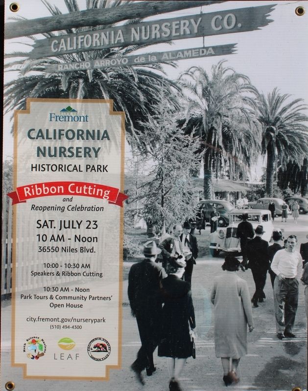
The California Nursery is closely associated with John Rock and George C. Roeding. In 1884, a German immigrant named John Rock purchased 463 acres on a site that is today known as the community of Niles in Fremont. He moved his start-up nursery . . . — — Map (db m208919) HM
James and Lucy Shinn established a nursery and ranch here in 1856. Joseph Clark and Florence Mayhew Shinn and their children carried it on until 1978. In 1962, Florence Shinn gave the City of Fremont this park with the 1876 ranch house and office, . . . — — Map (db m194709) HM
This winery was founded in 1869 by Leland Stanford, railroad builder, Governor of California, United States Senator, and founder of Stanford University. The vineyard, planted by his brother Josiah Stanford, helped to prove that wines equal to any in . . . — — Map (db m100554) HM
Henry Curtner, an enterprising American, arrived at Mission San Jose in 1852. He worked for farmers in the area. In 1856 Curtner returned home to Indiana to marry Lydia Kendall. By 1868 he was able to purchase the portion of Rancho Agua Caliente . . . — — Map (db m211572) HM
Between 1860 and the 1920s, the Meeks grew grains, green peas, corn, sugar beets, cucumbers, blackberries, and currants. Most of their land was in orchards of almonds, oranges, apricots, peaches, prunes, plums, and cherries. Meek’s land was . . . — — Map (db m210340) HM
As part of the City of Hayward’s commitment to sustainability, we promote healthy, environmentally-sound landscape practices.
Since 2009, the City required that large civic landscape projects be verified as Bay-Friendly Rated Landscapes. This . . . — — Map (db m208210) HM
This park is dedicated to the Hunt Brothers Cannery and the people of Hayward whose industry and loyalty made the cannery a success.
Established on this site in 1896 by Will and Joseph Hunt. By the mid 1940's, Hunt Brothers Cannery became the . . . — — Map (db m195817) HM
In 1869, William Meek’s success and expanding family motivated him to build a house worthy of his standing in the community. The resulting mansion is almost 7,000 square feet and has 19 rooms spread out over three floors. The house became the . . . — — Map (db m210988) HM
Built in 1869 by William Meek, a pioneer of commercial agriculture, the mansion is characteristic of the affluent agricultural society of the Victorian era in California.
The estate is on the site of the former Rancho San Lorenzo. This area . . . — — Map (db m149204) HM
There were many outbuildings on the Meek Property. In the early 1890s, the family built the carriage house for carriages and horses. The interior of the carriage house has been restored to replicate how the original building might have looked when . . . — — Map (db m210345) HM
Olivina is the name of the estate Julius Paul Smith built in the Livermore Valley. He and other local entrepreneurs recognized the similarities in climate and soil to the fine wine regions in Europe. The wines produced from their Valley estates . . . — — Map (db m196904) HM
Here, in 1883, James Concannon founded the Concannon Vineyard. The quality it achieved in sacramental and commercial wines helped establish Livermore Valley as one of America’s select wine growing districts. Grape cuttings from this vineyard were . . . — — Map (db m100553) HM
Here, Charles A. Wetmore planted his vineyard in 1882. The Cresta Blanca wine he made from its fruit won for California the first international award, the highest honor at the 1889 Paris Exposition, first bringing assurance to California wine . . . — — Map (db m100552) HM
Julius Paul Smith was born in Wisconsin in 1842. After fighting in the Civil War, he tried his hand in the farm machinery business and the grocery business. He married Miss Sarah Barker of New York in 1870 and soon headed west.
Julius joined . . . — — Map (db m196907) HM
The Livermore Rodeo exemplifies the City's western heritage. Early rodeos were held at the site of Los Vaqueros Reservoir and at the site of the present-day civic center.
The first modern Livermore Rodeo was held in 1918, located north of . . . — — Map (db m196959) HM
Born in England 1799 – Died Rancho Las Positas 1858. Arrived in Monterey 1822. Married Josefa Higuera y Puentes 1830. Settled on Rancho Las Positas 1835.
“Next to the Mission Fathers, he was the first man to engage himself in the culture of . . . — — Map (db m199846) HM
The Edward R. Campbell Bridge is a physical testament to the power of elected officials building bridges that benefit not only their constituents, but all future generations. Alameda County Supervisor Edward R. Campbell, having spent most of his . . . — — Map (db m204561) HM
Here the first Wente Vineyards of 47 acres was established by C.H. Wente in 1883. In 1935 his sons, Ernest and Herman, introduced California’s first varietal wine label, Sauvignon Blanc. The efforts of the Wente family have helped to establish the . . . — — Map (db m100563) HM
Designer: H.C. Baumann
Construction Date: 1929
Architectural Style: Early 20th century utilitarian with Art Deco elements
1926 was a profitable year for the Poultry Producers. Pooled resources created “orderly marketing” to . . . — — Map (db m228121) HM
Built in 1854, the Alviso Adobe is one of the few adobe structures remaining in the Bay Area. Declared a California Historic Landmark in 1954, the building stands relatively unmodified since the 1920s.
The adobe was in continuous use from 1854 . . . — — Map (db m24616) HM
was founded at this site in 1919 by Walter M. Briggs. His wife, Mary Phillips Briggs, named the dairy after the meadowlark birds that were commonly seen perched on fence posts.
Benches donated by the Takens family
Dedicated to the . . . — — Map (db m196200) HM
There were once many buildings on the Meadowlark Dairy complex. One important building was a place for the ranch hands and workers to sleep and socialize. This bunkhouse is a smaller version of the one that was at the dairy. The current Foothill . . . — — Map (db m196199) HM
These low boundary walls show the approximate location of the Meadowlark Dairy manager’s house. The dairy manager played an important role in day-to-day operations. His house had a kitchen, living room, office and bedrooms. A half-cellar under the . . . — — Map (db m196198) HM
Families living here planted fruit and nut trees in this area to the west of the building.
In the 1920s the Dana's, managers of the Meadowlark Dairy, planted walnut trees along the property edges and a small fruit orchard north of the . . . — — Map (db m196203) HM
At roughly 45 feet high, the Meadowlark Dairy silo was a distinctive visual landmark. This circular paving marks the silo’s approximate location. The original silo and barn were much larger. Silage, fodder for animals, is created by partially . . . — — Map (db m196197) HM
This home was built in the late 1870’s by Joseph Demont, a San Leandro pioneer who was active in industry and politics. Daniel Best bought the property in 1886. Best established Daniel Best Agricultural Works, which later became Caterpillar . . . — — Map (db m26380) HM
West side of marker:
San Leandro’s farmers expected a bumper crop of cherries in 1909. Why not celebrate and promote the city and one of its wonderful crops? The first cherry festival took place that spring. The Oakland . . . — — Map (db m26458) HM
West side of marker:
San Leandro’s first industries served the needs of farmers. In 1886, Daniel Best bought San Leandro Plow and formed Daniel Best Agriculture Works to manufacture tractors, combines, and harvesters. Best’s son . . . — — Map (db m26437) HM
The factory was built in 1870 by E. H. Dyer, “Father of the American Beet Sugar Industry.” Located on a corner of Dyer’s farm, the small factory began processing sugarbeets on November 15, 1870, and produced 293 tons of sugar during its . . . — — Map (db m100556) HM
Long before the structure pictured above was built, Ione's most notable civic building was
leveled by fire on June 10, 1923. The original building was constructed in 1893 by the
26th Agricultural District Fair Association and was known as the . . . — — Map (db m193551) HM
Property settled by J. P. Martin in 1848. Home built circa 1852. Purchased in 1882 by William Scully, who arrived from Ireland in 1854. The Scully family has owned and operated the ranch for five generations. Present owners are Robert and Etta . . . — — Map (db m42398) HM
Two German orphaned immigrant brothers come to the United States of America. One of them, John Hermann Deutschke finds his way to California and marries Maria Agnes Winter who was widowed on the journey west. In 1862, he purchases the first of . . . — — Map (db m176165) HM
The Foothill Station became the first University of California qualifying outlying station funded jointly by federal, state and local county sources in March 1888. The station was developed under the patronage of Senator A. Caminetti of Jackson. . . . — — Map (db m72065) HM
Chaw’se is the Miwok word for a mortar hole. The cup-shaped depression in a grinding rock was used to process acorns and other seeds into food by pounding and grinding with a cobblestone pestle.
The hole or chaw’se began as a . . . — — Map (db m71895) HM
Dedicated to the early Shenandoah Valley pioneers & their descendants. They mined gold & produced grain, livestock, orchards & vineyards in these rolling hills. Nearby are the old school, used for 100 years, and now a social center, and the cemetery . . . — — Map (db m10639) HM
A vast expanse covering 26,000 acres, Rancho Chico was purchased in 1849-50 by John Bidwell. In 1865 he began construction of the mansion nearby, which in time became the social and cultural center of the upper Sacramento Valley. It was through his . . . — — Map (db m230785) HM
Completed in 1868, the home featured many surprisingly modern conveniences including running water, flush toilets, an acetylene gas lighting system, eight fireplaces, and wall-to-wall carpeting. The pink stucco mansion was designed by San Francisco . . . — — Map (db m29644) HM
Judge Joseph Lewis planted this Mediterranean Sweet Orange seedling near the toll bridge at Bidwell’s Bar, Butte County, California in 1856. It has survived hard times and is the oldest living orange tree in California. “From its example and . . . — — Map (db m143395) HM
Imported from Mazatlan, Mexico, the Mother Orange Tree was purchased on the streets of Sacramento when it was only a 2 to 3 year-old seedling in a tub. She was planted in 1856 and quickly grew into a California legend. The leafy greens of her robust . . . — — Map (db m62787) HM
In deep appreciation of those who had the foresight to plan, design, and construct the Oroville Dam Project and to those who have been operating and maintaining it for the State Water Project and the people of California.
Since its . . . — — Map (db m101447) HM
To commemorate The Mother Orange Tree of Butte County planted at this spot by Judge Joseph Lewis in 1856.
The Bidwell Bar Bridge, first suspension bridge of California, transported from New York via Cape Horn 1853. Completed 1856. . . . — — Map (db m100596) HM
Fashioned as either small ornaments or large enough to be heard for miles, bells have long been a part of human history and culture. First appearing around 2000 B.C. as simple percussion instruments, they continue to celebrate special events to this . . . — — Map (db m101587) HM
Josephine Felix arrived from France in 1852, one of the first settlers in Salt Spring Valley. Soon widowed, she established a waystation at the junction of the Angels and Central Ferry Roads. She wed neighbor Alban Hettick and the couple developed a . . . — — Map (db m58929) HM
In 1859 Tacitus Ryland Arbuckle located a homestead in the Sacramento Valley, and in 1875 had the land plotted for a town site. The legendary Arbuckle founded the town, deeded the lots, furnished the nails, and helped build the first houses in what . . . — — Map (db m54548) HM
Spurs and Branding Irons
California Cowhides are Big Business
After Spain's rule in the New World ended in 1821, the newly
established government of Mexico began the process of distributing
the mission lands. The area where you . . . — — Map (db m185763) HM
In the early 19th century many canneries operated throughout California. The rich agricultural and fishing areas of east Contra Costa County hosted a number of canneries and packing sheds. The picturesque Antioch waterfront was home to two canneries . . . — — Map (db m18292) HM
This little house built by the McCoy's in 1861, at their ranch on the side of Kirker Pass, served as their first home. As time passed and the ranch became established, a much larger farmhouse was built for the family. It was then that the 2 room . . . — — Map (db m93574) HM
This house, which serves as the museum for the East Contra Costa Historical Society, was originally built by Johnson and Elizabeth Fancher in 1878. In the early 1880's the Fanchers sold the house and surrounding acreage to John and Letitia Byer. In . . . — — Map (db m94652) HM
Drainage Area 33,000 Acres
Total Capacity 4,800 Acre Ft.
Water Surface Area 375 Acres
Height of Dam 58 Feet
Length of Dam 1,500 Feet
Volume of Fill 440,000 Cu.Yds.
Built under the Watershed Protection and . . . — — Map (db m198002) HM
Miwok Indians inhabited this valley at the base of Mt. Diablo when Spanish explorers came in the 1770’s. Scouts, trappers, prospectors and settlers followed.
In 1857 Clayton was founded by Joel Clayton, a miner, farmer, and wagonmaster from . . . — — Map (db m59954) HM
Paul De Martini built Clayton Vineyards Winery in 1885 on land formerly owned by Joel Clayton, the area’s first vintner. An Austrian stone mason directed construction, using stone quarried on Mount Diablo and hauled here by wagon teams. This was the . . . — — Map (db m60033) HM
Pioneers, miners & cowboys along with ranching and farming have
all been important parts of Clayton's history. Founded by Joel
Clayton in 1857, he laid out the downtown, established his cattle
ranch and planted 28 acres of vineyards.
When . . . — — Map (db m190219) HM
As early as 2000 BC, this area was home to the Volvon Miwok Native Americans. Many artifacts of their lifestyle were found when American settlers arrived in the 1800s.
Under the Homestead Act between 1862 and 1872, Clayton's founder, Joel Clayton . . . — — Map (db m150414) HM
Don Salvio Pacheco was born on July 15, 1793 in Monterey, Alta California. After serving in the Monterey Militia for many years, he petitioned the Territorial Deputation Council of the Mexican government for a Land Grant in 1834. With the possession . . . — — Map (db m206217) HM
Crockett Ranch Staging Area is the gateway to 1,300 acres of scenic and secluded parkland that make up Crockett Hills Regional Park. Long held as private ranchland, the area has always offered a quiet counterpoint to the hustle and bustle of the . . . — — Map (db m190311) HM
Ranching has long been a way of life in these
hills. With steep terrain, and water in scarce
supply, the area has always favored cattle grazing
over cultivation of water-intensive crops.
The region once formed part of the vast . . . — — Map (db m190310) HM
Settling in Danville from Virginia, early pioneers Robert B. Love and Amelia Harvey Love owned most of the land that is now “West Danville.” Once surrounded by orchards and a bee farm, this is one of the oldest remaining original farmhouses in . . . — — Map (db m202119) HM
(front or street side:)
"My parents were given much help
(from the Adachis and Nabetas)
digging a well by hand and building
their house. Much help was given on
how to grow the flowers as well as
how to build the greenhouses. . . . — — Map (db m145945) HM
(front or street side:)
"At four in the morning they would
start preparing the flowers for market.
Grandfather would carefully put the
flowers in a basket and sling it over
his shoulder. Grandmother, carrying
a lantern, would lead him . . . — — Map (db m156299) HM
In front of you is the last remaining structure of El Cerrito's once vibrant Japanese American flower growing industry: the former storefront of Contra Costa Florist which was owned by the Mabuchi Family.
Hikojiro and Tomi Mabuchi, aided . . . — — Map (db m145944) HM
El Cerrito was once a town of farms and dairies. The mild weather, lush fields, and many creeks coming down from the hills made for excellent dairy farming. Over the years, there have been about 25 dairies located in El Cerrito. — — Map (db m94131) HM
El Sobrante never attracted heavy industry. Probably the largest commercial enterprise in the town was the S.P. Skow & Sons Dairy, which supplied milk in Richmond and surrounding towns. For most of that time, the dairy was located on Clark Road, . . . — — Map (db m94273) HM
El Sobrante gets its name from Rancho El Sobrante, "surplus" land situated between existing ranchos that in 1841 was granted by the government of Mexico to brothers Juan Jose and Victor Castro. Curiously, El Sobrante's downtown is actually within . . . — — Map (db m94305) HM
In the city, from 1879 to 1932, the 70 acre parcel of land extending in a triangle from what is now Bush Street to Pacheco Boulevard to Brown Street to Alhambra Creek was owned by The Christian Brothers Religious Teaching Order, Founded by Saint . . . — — Map (db m112828) HM
Vicente Martínez was born in Santa Barbara on August 18, 1818, the second son of Don Ygnacio and Martina de Arellano Martínez who were married in the Presidio Chapel at Santa Barbara 1802. Don Ygnacio Martínez was a Spanish officer at San Diego and . . . — — Map (db m50827) HM
In 1919, Colonel Robert Bradford Marshall
of the United States Geological Survey
proposed an unprecedented project
of dams, canals, and pumps to
move Delta-bound water from
California's wet north and snowy
Sierra Nevada mountains to its
arid . . . — — Map (db m190979) HM
Fifty Years
That's all it took for the clamshell dredge to change the
Delta from a vast wetland into the agricultural, water
delivery, and shipping hub we know today. In the late
1880s, these dredges reshaped the waterways to ease . . . — — Map (db m190314) HM
Picture a river running through a desert.
Now picture a desert running through a river.
The San Joaquin River once flowed
uninterrupted from high mountains,
through the arid valley bearing its name,
to the Delta. Floods enriched . . . — — Map (db m190726) HM
Patrick Rodgers left Ireland for America C. 1843 at the age of 10, without his family. In 1855, he arrived in California for the Gold Rush. In 1868, he and his wife, Mary Ann, bought this 149-acre site to grow wheat. The Rodgers, along with eight . . . — — Map (db m99625) HM
At Forest Home Farms, much of the food was home grown. The Boones grew vegetables for their own use and raised cattle on a leased ranch in Livermore which they brought to the meat house, in front of you, for processing. This structure was . . . — — Map (db m202114) HM
Take a walk down the path and imagine what life might have been like here 200 years ago. Oak Creek would have provided fresh water and an abundance of plant material and wildlife for food and shelter. Houses would have been built with willow . . . — — Map (db m202104) HM
Welcome!
Forest Home Farms was one of many ranches in the San Ramon Valley in the early 1900s. Originally part of a Mexican land grant, the property was farmed, built upon, and subdivided over the years. In 1899, 163 acres were purchased by . . . — — Map (db m202115) HM
Man power or animal power – that was the choice for most farmers up until the 1930s to till, sow and reap their crops. Gas engines existed from the early 19th century but were only able to do stationary farm and household chores like grinding grain, . . . — — Map (db m202111) HM
Getting a drink of water in the early 20th century was not as easy as it is today. You couldn’t just turn on a tap. You had to use a windmill to extract groundwater which was then fed into a holding tank. The water flowed by gravity to a cast iron . . . — — Map (db m202059) HM
San Ramon's Pioneers
American pioneers first came to San Ramon in 1850 when Leo and Mary Jane Norris
purchased 4,450 acres of land from Jose Amador's Rancho San Ramon. Other early
landowners were William and Mary Lynch, James and . . . — — Map (db m155606) HM
There was always work to be done on the ranch. Each year the Boones ran a walnut processing operation which included washing, hulling, and drying for local walnut farmers. Travis Boone owned one of the few hay harvesters in the valley. At the end . . . — — Map (db m202113) HM
Minnie Boone purchased Forest Home Farms in 1899. The Boone House was built in 1900 and is a Dutch Colonial style home with 5375 square feet and 22 rooms. The older north wing of the home is Gothic style and pre-dates the Boone’s ownership to the . . . — — Map (db m202102) HM
A farm is a complicated endeavor to run. Equipment must be maintained, repaired and stored; crops must be planted, harvested, and kept dry until needed; and farm animals must be fed and sheltered. Specialized buildings are needed, serving many . . . — — Map (db m202106) HM
Animals were an essential part of the ranches and farms of the last century. Horse were especially important to farm life, for they provided transportation, pulled plows, and other farm equipment, hauled cargo, and even powered machines that did . . . — — Map (db m202108) HM
Used for sowing seeds in the fields. Most early farm machinery were Rube Goldberg-like contraptions. When the wagon wheels turned, the gears fastened to them turned other gears. — — Map (db m93982) HM
First model built by International Harvester in 1924. Designed to cultivate or weed between rows. Instead of the traditional side-mounted flywheel to which a belt was attached to run machinery, the Farmall had what was known as a "power take-off," a . . . — — Map (db m93979) HM
Originally located at the Cereghino Ranch of Walnut Creek
Relocated to Shadelands in 1995
Restoration of the buildings was made possible by the efforts of:
Walnut Creek Historical Society
Joseph Bologna, Project Architect
Primo E. . . . — — Map (db m209652) HM
After mining started to decline in the mid-1850s, the local people turned to agriculture. Among them was Henry Mahler, who had over 1,500 fruit trees on this site in the 1860s. Henry Mahler Sr. died in 1867, and Henry Jr. took over the farm. Most of . . . — — Map (db m215741) HM
Mining ditches were dug by ditch companies to carry vast amounts of water needed for placer mining. Thousands of miles of ditches and flumes were built in the gold country; some brought immense profits to their owners. As mining declined in the . . . — — Map (db m17484) HM
The home of the pioneer Monroe family stood here for more than a century. The family matriarch, Nancy Gooch, came across the plains from Missouri as a slave in 1849. She gained her freedom in 1850 when California joined the Union as a . . . — — Map (db m17455) HM
Pearly Monroe was a grandson of Peter and Nancy Gooch, who were freed from slavery here when California became a state in 1850. The Monroe family became successful fruit farmers and prominent property holders in Coloma. This house was built by . . . — — Map (db m17205) HM
This area held a number of important homes and stores during the gold rush. The first large building in Coloma was built here in 1849 by John T. Little. It contained a store, hotel, restaurant and post office. Little also operated a ferry to cross . . . — — Map (db m215742) HM
Most of Coloma's buildings were wooden, but some were were made of brick or stone to resist fire. This one, known as "Bells Brick Store," was a general merchandise store that also sold feed and grain. The U.S. Post Office was located in this . . . — — Map (db m12207) HM
This town, settled in 1848, derived its name from its crystal clear springs. Among the richest in this vicinity its diggings produced a 25 pound nugget, one of the largest in El Dorado County. Its most thriving period was in 1851. Later it became a . . . — — Map (db m10936) HM
Site of the only tea and silk farm established in California. First agricultural settlement of pioneer Japanese immigrants who arrived at Gold Hill on June 8, 1869. Despite the initial success, it failed to prosper. It marked the beginning of . . . — — Map (db m76181) HM
This fieldstone building was built by Giovanni N. Lombardo in 1872 from stones cleared to plant vineyards on the property. The lower cellar was used to produce wine for the local community. The grapes were crushed in the upper story living room and . . . — — Map (db m101534) HM
Whose deep concern for the conservation and improvement of our forests led him to establish the Eddy Tree Breeding Station on this site in 1925. His own effort and funds created this oldest forest genetics research institution in the Western . . . — — Map (db m105854) HM
Jacob Zwang was born in Sennefeld, Baden Germany and migrated to the United States in 1896 at the age of 16 years. He arrived at 2:00 o’clock in the morning and was met by his uncle Moses Levy, and cousin Albert Levy. This was the start of a . . . — — Map (db m64061) HM
[Side A:]
Easton
In 1878, O.W. Easton and J.P. Whitney, San Francisco entrepreneurs, bought a total of 12 sections of land in this area (7680 acres), formed the Washington Irrigated Colony and began selling 20-acre farms. Allen T. . . . — — Map (db m229962) HM
6661 entries matched your criteria. Entries 201 through 300 are listed above. ⊲ Previous 100 — Next 100 ⊳