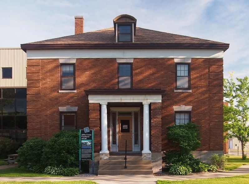
The original courthouse built on this site in 1887 included a jail and sheriff's residence. It served a population of about 2,000 people. As a logging town, Aitkin became a railhead and an important stopping point for boats on the Mississippi . . . — — Map (db m127867) HM
On Mandy Lake Access at 363rd Lane, on the left when traveling west on Mandy Lake Access.
Settlement
In the late 1800s, the first white settlers came to the area that is now the refuge. They were loggers, ranchers and market hunters. Loggers cut the pine trees from the land and floated them down the Rice River to the Mississippi . . . — — Map (db m210313) HM
Near State Highway 65, 0.6 miles 224th Place, on the right when traveling north.
In late 1850, some 400 Ojibwe Indians perished because of the government’s attempt to relocate them from their homes in Wisconsin and Upper Michigan to Minnesota west of the Mississippi River. The tragedy unfolded at Sandy Lake where thousands of . . . — — Map (db m206878) HM
Near 531st Lane east of Highway 65, on the right when traveling north.
Of the American Fur Company was established near here about 1830, after an earlier location further south at the Northwest Company’s station had been abandoned.
William A. Aitkin for many years was a leading trader in this region. Indian . . . — — Map (db m207745) HM
On State Highway 65, on the right when traveling north.
This map shows the locations of some of the villages of the 19 Ojibwe Bands whose treaty annuities were paid at Sandy Lake in 1850. Today, these 19 Bands are succeeded by the 12 federally-recognized Bands whose present-day reservations also are . . . — — Map (db m207530) HM
On Minnesota Route 65, 0.2 miles south of 528th Lane, on the right when traveling north.
To the native Anishinabe (Ojibwe) and to the white fur traders who bartered with them in the late 1700s and early 1800s, no Minnesota lake had a more strategic location than Big Sandy Lake, which stands at the intersection of two major trade . . . — — Map (db m210859) HM
Robert W. Akin (1871-1920) came to Anoka in 1898 and began working as a cashier in the State Bank. His property a few blocks south of Main Street on the east bank of the Rum River was said to be one of the "most picturesque sites in the . . . — — Map (db m162173) HM
Near South Ferry Road, 0.3 miles east of South Ferry Street.
Native peoples and traders met at a trading post constructed across the Rum River from The Point in 1844 by Joseph Bellanger. The Ojibwa brought furs and skins to trade for copper cooking pots, cloth, blankets, decorative beads and iron . . . — — Map (db m70921) HM
Who Lived Here
Thousands of years ago, glaciers and inland seas covered much of North America. These early forces shaped the land to form lakes, rives, soil deposits, and land features. Sandy soil at the southern end of the Rum River . . . — — Map (db m236855) HM
Why Settle Here? Looking for Work
Timber was a resource that drew many west and in 1847, surveyor Daniel Stanchfield noted, "Seventy mills in seventy years couldn't exhaust the white pine I have seen on the Rum River". The rivers . . . — — Map (db m70982) HM
On E. River Road at 51st Way N.E., on the right when traveling south on E. River Road.
1880 – Albin Riedel immigrated from Germany to New York City. He accepted a job offer to work on a farm in Minnesota. After earning enough money, he purchased land in Fridley and built this large farmhouse.
1889 – Swedish immigrant, . . . — — Map (db m248740) HM
On U.S. 10, 0.8 miles east of Cleveland Street, on the right when traveling east.
Itasca grew up around an Indian trading post which was established 800 feet east of here in 1849 by Thomas A. Holmes and James Beatty. At the suggestion of Territorial Governor Alexander Ramsey, the settlement was named in honor of Lake Itasca, the . . . — — Map (db m69908) HM
On Rum River Blvd NW at Bridge St NW (County Road 24), on the right when traveling north on Rum River Blvd NW.
The Rum River, a 148 mile river of gradual grade, is rich in history. The French explored it. The Chippewa and Sioux fought along it, and the pine logs that helped build the cities of the Midwest were floated down it during the lumber boom of the . . . — — Map (db m94721) HM
Near County Highway 11, 1.5 miles south of U.S. 10, on the left when traveling south.
This plot marks the site of the home of John Cook, pioneer settler, who with his wife Diantha J., and children Freddie W., Mary E., and John W., were murdered by Indians April 26, 1872. — — Map (db m227703) HM
On Frontage Road (U.S. 10) 0.1 miles south of North Shore Drive, on the right when traveling south.
This lake and the city located on its northern shore received its name from the French word “détroit,” meaning a narrow place in a lake and in this case referred to the bar which divides Little and Big Detroit Lakes. Today this can be seen about . . . — — Map (db m233589) HM
On County Road 29, 1 mile south of County Road 26, on the left when traveling south.
This trail was used by early settlers and Indians to reach the maple sugar and wild rice campsite located at the north end of Tamarac Lake. It extended east to the Ottertail River and then branched to the south and north. The south branch followed . . . — — Map (db m226131) HM
Minnesota is one of the few states where the Red River Ox Cart was used extensively as a mode of transportation. From 1832 to 1862 the carts went back and forth between St Paul and the fur trading outposts at Pembina, ND and Fort Gary in Canada. . . . — — Map (db m232425) HM
On County Route 143, 0.7 miles west of Egg Lake Trail.
This marker locates a part of the original trail which was cut out of the forest by the U.S. Army in 1868 to facilitate travel from Leech Lake to White Earth. Soldiers accompanied the paymasters along this road in the early days to provide . . . — — Map (db m8537) HM
Near 370th Street, on the left when traveling east.
The first Minnesota mission to be named for Saint Columba was built by James Lloyd Breck in 1852 at Gull Lake near the present-day Brainerd. It was the fourth Episcopal church established in Minnesota.
The initial group of Chippewa Indians . . . — — Map (db m207531) HM
Near State Highway 72, 2 miles south of County Road 77, on the left when traveling north.
In 1891, government surveyors platted this area as "meadows." Travel was difficult until drainage ditch spoil piles provided a rough bed for the first road, present-day Highway 72. A road linking Baudette and Kelliher was completed in 1914. . . . — — Map (db m191359) HM
Near State Highway 72, on the left when traveling north.
An early 20th century attempt to drain the bog failed, but the old ditches still mark the invincible, yet fragile landscape.
Taking on the Bog
In 1889, the federal government appropriated almost three million acres of the Red Lake Indian . . . — — Map (db m191353) HM
Near Waskish Road NE (County Road 40) west of State Route 72.
Waskish was named by the Chippewa Indians who hunted, fished, and gathered wild rice along the Tamarack River. The Ojibway word for deer is Wawaskishi, which was shortened to Waskish by the early pioneers. The old town site was located at the . . . — — Map (db m181008) HM
On 1st Street North just south of 3rd Avenue North, on the right when traveling north.
Minnesota Territory 1849-1858On March 3, 1849, during his last hours in office. President James K. Polk signed a bill adding a new name to the American political landscape — Minnesota Territory. A vast land, it stretched from the St. . . . — — Map (db m205213) HM
On St Marys Avenue (Minnesota Route 28 at milepost 22), 0.9 miles west of U.S. 75, on the right when traveling west.
About 1866 a trading post on the Fort Wadsworth Trail was established on
Tokua Lakes a mile west of town. Early in 1878 Archbishop Ireland, after erecting a church on the present town site, located several hundred families in the vicinity through . . . — — Map (db m156662) HM
On County Route 28 at Bloomington Ave. N, on the right when traveling east on County Route 28.
The village of Odessa began in 1879 with it's first settler, A.D. Beardsley. He was the Milwaukee depot agent and owner of the first general store. Mr. Beardsley lost a three-year-old daughter, Dessa, to diphtheria. It was after this girl that the . . . — — Map (db m100967) HM
On State Highway 68 at 227th Lane, on the right when traveling east on State Highway 68.
The above locations of Welsh Churches were established in Blue Earth County after the first Welsh settlers expanded from this farm site, which was claimed by Humphrey Jones and Thomas Y. Davis on April 26, 1855.
In the wooded area . . . — — Map (db m203325) HM
On East Robinson Street east of North Main Street (County Highway 76), on the right when traveling east.
"Who says we cannot build railroads in the winter?" asked the Mankato Weekly Union on December 10, 1869, in an article announcing that the tracks of the St. Paul & Sioux City Railroad had reached the new town of Lake Crystal.
The . . . — — Map (db m67364) HM
On Civic Center Plaza (Hickory Street) west of South 2nd Street, on the right when traveling west.
European settlers began arriving in the area in the 1850s. The Treaty of Traverse des Sioux, signed July 23, 1851, allowed settlers to claim land that had once belonged to the Dakota. In 1852, Parsons King Johnson and Henry Jackson claimed the . . . — — Map (db m236258) HM
On South Broad Street at Warren Street on South Broad Street.
Rensselaer Dean Hubbard, successful entrepreneur and civic leader, built his house on Broad Street in three stages: in 1871, 1888 and 1905. During the
late 19th century, many of Mankato’s captains of industry and commerce established their . . . — — Map (db m66338) HM
Built in 1857 in Mankato Township and was moved to this site, which was once the site of the fur trading post of Henry H. Sibley by the Blue Earth County Historical Society in 1931. — — Map (db m66845) HM
On October 3, 1887 the City of Mankato purchased 120 acres for $13,088 at the confluence of the Blue Earth and Minnesota Rivers to create Mankato’s first park. Sibley Park was named for Henry Hastings Sibley (later Minnesota’s first Governor) who . . . — — Map (db m66483) HM
On Center Street (County Road 32) at Second Street on Center Street.
Cobden is a railway village in Prairieville Township. It was originally named North Branch because of its location near Sleepy Eye Creek, the principal north branch of the Cottonwood River. In 1886 its name was changed to Cobden for the English . . . — — Map (db m69835) HM
On 1st Street at Main Street (County Road 11) on 1st Street.
On April 8, 1885 Chief Engineer Blunt of the Winona & St. Peter Railroad Co. announced that the railroad had decided to build a side track between New Ulm and Sleepy Eye for the purpose of receiving grain. The site was known only as "Siding Number . . . — — Map (db m67411) HM
On County Road 11 at County Road 29, on the left when traveling north on County Road 11.
In the summer of 1862, after years of broken treaty promises and late payments that fueled growing tensions and conflict, some Dakota began an attempt to forcibly reclaim their homeland. After attacking the Redwood (Lower Sioux) Agency . . . — — Map (db m67915) HM WM
On Knudsen Street (County Road 31) south of Hanson Street (County Road 7), on the left when traveling south.
On May 24, 1887 Nels Hanson platted the small railroad station point in section 8 of Prairieville township as "Hanson Station". A post office had been established in 1886 named Evan by the first postmaster, Martin Norseth, in honor of Hanson's wife . . . — — Map (db m69831) HM
On County Road 257, 0.4 miles east of 155th Avenue, on the left when traveling east.
In 1854 Ole and Guri Sorbel immigrated to Rock County Wisconsin from Hallingdal, Norway. In 1856 they settled to your right on the northwest bank of Lake Linden. On September 21, 1876, Bob, Cole and Jim Younger and Charlie Pitts received breakfast . . . — — Map (db m68073) HM
On Broadway (State Highway 257) at 2nd Street East on Broadway.
In 1899, the Iowa and Minnesota Land & Townsite Company circulated a petition to locate a railroad station in Lake Hanska Township. The petition was signed by 77 people and on October 9, 1899 the village of Hanska was platted in section 24 by Harry . . . — — Map (db m66468) HM
On County Road 257, 0.4 miles east of 155th Avenue, on the left when traveling east.
This memorial is dedicated to the memory of John Armstrong pioneer of Linden Township, in 1857 he represented this part of Brown County as its first Territorial County Supervisor (Commissioner) and later became Linden Township's first . . . — — Map (db m68083) HM
Near County Road 11, 1.1 miles north of County Road 6, on the left when traveling north.
Ole Synsteby was born in Lesja, Gulbrandsdalen, Norway. In the summer of 1873, the Synsteby family migrated to the Lake Hanska area. In 1879 Ole purchased the land which is now designated as Lake Hanska County Park.
The story of . . . — — Map (db m79934) HM
On Broadway (State Highway 257) north of Blessum Street (State Highway 257), on the right when traveling south.
This structure is a replica of many such stabburs found in Norway. There are several variations. "Stabbur" translated means store house.
Benefactors: James & Ferdi Amundson estate.
These Lake Hanska farmers were descendants of Norwegian . . . — — Map (db m68264) HM
Near County Road 11, 1.1 miles north of County Road 6, on the left when traveling north.
This log cabin was built about 1857 by the Omsrud/Thordson and Torgrimson families, immigrants from Valdres, Norway. It originally stood on the Thord Omsrud farm on the shores of Omsrud Lake. The cabin was moved to this site in 1986 by . . . — — Map (db m66437) HM
On County Road 24, 0.5 miles east of County Road 8, on the left when traveling east.
About 5 blocks north of this marker was the location of a very important river crossing for the early settlers of this area, going from the "Shetek Trail" on the south to "Old Leavenworth" and New Ulm on the north side of the Cottonwood . . . — — Map (db m67709) HM
On County Road 24, 0.1 miles east of County Road 8, on the right when traveling east.
In 1857, settlers platted a townsite in Section 14 of the Leavenworth area. During the next year, Dr. J. B. Calkins established the post office and became its first postmaster. Leavenworth Township was legally organized on April 16, 1859. Seven . . . — — Map (db m68025) HM
On County Road 24, 0.9 miles west of County Road 8, on the right when traveling west.
The Joseph Brown family with son Jonathan and daughter Oratia were early settlers on a farm five miles west of here along the Shetek Trail. The family fed and over-nighted guests, operating their home as a traveler's inn. Upon hearing news of Dakota . . . — — Map (db m67825) HM
On Cottonwood Street, 0.2 miles west of South Broadway Street (Minnesota Highway 15 / 68), on the right when traveling west.
Christian Adam(s) was born circa 1812 in Prussia. He sailed from LeHavre, France aboard the ship Pactolus which arrived in New York City October 12, 1846. The passenger manifest listed his occupation as farmer.
Petronella Keller Adam(s) was . . . — — Map (db m73759) HM
Near North Minnesota Street south of 3rd North Street, on the left when traveling south.
Following the outbreak of hostilities between the Dakota and white settlers on August 18, 1862, hundreds of people fled from nearby farms to New Ulm for safety. Quickly, Brown County Sherriff Charles Roos and Jacob Nix, a citizen with German . . . — — Map (db m73140) HM
On South State Street south of Center Street, on the right when traveling south.
Brown County, an historic gateway on the Minnesota River, opened the fertile prairie lands of the Great Plains to the northern hardwoods of a continental divide. The U.S. Territorial Legislature organized the county in 1856 from lands ceded by the . . . — — Map (db m66749) HM
On North Minnesota Street south of 3rd North Street, on the right when traveling south.
This three-story building is a fine example of Queen Anne commercial architecture. The original southern section was erected in 1892 for the Buenger Furniture Store, while the corner building was constructed in 1902.
Louis Buenger Sr. . . . — — Map (db m68117) HM
Near Highway 26 west of Summit Avenue when traveling west.
The colorful frontiersman credited with giving Minnesota the nickname of the Gopher State was born in 1828 in New York City of French Huguenot and Irish ancestry. As a young lawyer he moved to Minnesota in 1853. After exploring the Minnesota River . . . — — Map (db m206944) HM
On Pfaender Drive, 0.2 miles north of 5th North Street (County Highway 27), on the right when traveling north.
Colonel Wilhelm Pfaender (1826-1905), born in Heilbronn, Wurttemberg, Germany, came to America as a result of the 1848 Revolution. In Germany he helped found the Turner Societies in his birth-city of
Heilbronn and in Ulm. In Cincinnati, Ohio, he . . . — — Map (db m73673) HM
On County Highway 25 west of 140th Avenue, on the right when traveling west.
Valentine Sommereisen was the first resident Catholic priest in three large areas of the American West: southwestern Minnesota, the Dakota Territory, and western Kansas. Born 28 May 1829 in Rouffach, Alsace, a German–speaking part of eastern . . . — — Map (db m74222) HM
On South Front Street at 2nd South Street, on the right when traveling north on South Front Street.
Goosetown began forming around the flour mills, brewery, and railroad tracks circa 1870. Settlers were largely German-Bohemian Catholics of peasant stock who farmed and worked in nearby industries. Inhabitants kept geese which were free to roam, . . . — — Map (db m58435) HM
On North German Street at North 2nd Street, on the right when traveling north on North German Street.
This monument was erected in 1991 by the German-Bohemian Heritage Society to commemorate the immigrants to this region from the German speaking western rim of present-day Czechoslovakia. They emigrated from the counties of Bischofteinitz, Mies and . . . — — Map (db m67030) HM
On Broadway (State Highway 15 / 68) at Center Street on Broadway.
By the end of the fighting in New Ulm, the U.S.—Dakota War of 1862 had taken a heavy toll on the town. More than 50 settlers had been killed and 36 wounded, along with an unknown number of Dakota. In addition, at least 190 of the . . . — — Map (db m74136) HM
On County Road 21, 0.3 miles west of 661st Avenue, on the left when traveling west.
West Newton in 1870 was a thriving town, serving riverboat travel on the Minnesota River. It consisted of a hotel, a livery stable, a brewery, a sawmill, a wagon works, two blacksmith shops, three saloons, and many dwellings that made the town an . . . — — Map (db m66238) HM
On 2nd North Street at North Broadway on 2nd North Street.
Jacob Nix from Bingen Am Rhein in Germany was a key figure in the defense of New Ulm in 1862. Born in 1822, Nix early joined the push for a united Germany under a republican form of government. During the ill-fated 1848 Revolution, Nix served as . . . — — Map (db m65455) HM
On Schell's Road, 0.1 miles south of 18th Street South, on the left when traveling south.
In the early 1870's, fourteen settlers purchased this beautiful spot located on the north bank of the Big Cottonwood River and named it Jägers Ruhe (Hunters' Rest). The objectives of this group of hunters was to preserve this property for their . . . — — Map (db m66087) HM
On North Broadway (State Highway 15/68) north of 1st North Street, on the right when traveling north.
In 1851, leaders of the Dakota Nation signed the Treaty of Traverse des Sioux with the United States Government. This treaty opened new lands in Minnesota Territory for settlement. Two years later, German immigrants in Chicago, led by Frederick . . . — — Map (db m65452) HM
On 3rd North Street at North German Street on 3rd North Street.
Frederick Beinhorn and Wilhelm Pfaender, pioneer founders of the prairie colony of New Ulm, were cut of the same cloth. Both came to America from Germany after the 1848 Revolution in Central Europe failed to unite German peoples under a new frame of . . . — — Map (db m65694) HM
On South State Street south of Center Street, on the right when traveling south.
To pay homage to the sturdy pioneers who founded the territory of Minnesota a century ago. And to express veneration for the pioneers of Brown County and members of their families who lost their lives during the Sioux War of 1862 — 1863. . . . — — Map (db m73642) HM WM
On 17th Street South east of South Franklin Street, on the left when traveling west.
This neighborhood dates back to the early days of New Ulm. Oral history suggests the borders shown above. The origin of the name “The Wallachei” is obscure. The most likely translation is “low land horse pasture.” Or, legend . . . — — Map (db m65396) HM
Near Monument Street north of Center Street (County Road 13), on the right when traveling north.
Henry A. Subilia, a native of Jean, Italy, constructed the Waraju distillery in 1861. The construction cost total of $8,000, plus $2,000 for furnishings. The building required approximately 200,000 bricks and measured 72 feet x 46 feet. It obtained . . . — — Map (db m153916) HM
On Main Street at Broadway Street (County Road 24), on the right when traveling west on Main Street.
Searles, a small community in Section 21 of Cottonwood Township, was platted on October 10, 1899, by Harry and Anna Jenkins. It was a railroad station point named by officials of the Minneapolis and St. Louis Railroad.
The original plat . . . — — Map (db m67914) HM
On State Highway 4, 0.3 miles north of 295th Street, on the left when traveling north.
The village of Golden Gate occupied this area for some years. The town took its name from the U.S. Post Office established in 1868 with Ebenezer Fuller in charge.
Construction of a water-powered grist mill on Spring Creek in 1869 by . . . — — Map (db m70993) HM
In 1866 the budding village of Iberia had a log school house, four frame buildings and a cemetery. The settlement is the center of Stark Township, organized in 1866.
Iberia crossroads was named for a community in Ohio because many of the first . . . — — Map (db m73752) HM
On County Road 24 at 370th Avenue, on the left when traveling east on County Road 24.
In the 1850s there was a land boom in southern Minnesota. Jonathan Brown, 37 years old, filed on land along the Cottonwood River in what is now Burnstown Township. (S 1/2 of SW 1/4, Sec. 15; N 1/2 of NW 1/4 of Sec. 22)
Jonathan picked a good . . . — — Map (db m67820) HM
On East End Avenue (County Highway 5) at East Rock Street (U.S. 14) on East End Avenue.
John and Daniel Burns were pioneer settlers in this area of brown County. Burnstown Township was named in their honor.
Railroad construction advanced westward and the name of the station stop here in 1873 was "Burns." A small settlement . . . — — Map (db m67542) HM
Near State Highway 210, 3.9 miles east of State Highway 45, on the right when traveling east.
One half mile south of this point lie three islands, known as numbers 1, 2, & 3, in the St. Louis River, which were settled by Josiah Boardman Scovell, original U.S. patentee in 1881, who retained ownership for the balance of his life.
Islands . . . — — Map (db m53857) HM
On State Highway 73 at Automba Road (County Road 6 & 131), on the right when traveling north on State Highway 73.
In memory
of the Finnish pioneers who arrived here in the western part of Carlton County in 1872 and thereafter, and made their homes with courage and perseverance.
Erected 1952 by Minnesota Finnish American Historical Society Chapter No. . . . — — Map (db m3266) HM
On North Walnut Street south of East 4th Street, on the right when traveling south.
City Square Park
City Square in Chaska has always been a gathering place and the heart of this community. The land was set aside for public purpose in 1852 in the original plat. Early settlers in Chaska found six earthen mounds on this . . . — — Map (db m63707) HM
On North Chestnut Street (State Highway 41) at Hundertmark Road, on the left when traveling north on North Chestnut Street.
This silo marks the site of the Christian Bender farm, homesteaded in 1854. George Bender, grandson of Christian, sold the farm to Henry McKnight in 1963. This was the first farm to become part of Jonathan.
Dedicated . . . — — Map (db m60394) HM
On 1st St NW at County Highway 25, on the right when traveling east on 1st St NW.
James J. Hill
The Dakota Rail Regional Trail follows the route of a former railroad line that was once part of the Great Northern Railway. Built by James J. Hill in the late 1800s, this historic line played a part in connecting Minnesota to . . . — — Map (db m98390) HM
Near Grimm Road west of Victoria Drive (County Route 11), on the right when traveling west.
The Big Woods
When the first Euro-American settlers came to this area in the 1850s, the land looked very different than it does today. At that time, the spot where you now stand would have been near the center of a two-million-acre hardwood . . . — — Map (db m212415) HM
Near Mill Avenue Northeast, 0.1 miles north of Carter Street Northeast, on the left when traveling north.
Watertown is one of the oldest settlements in Minnesota’s south central region. Chief Little Crow of the Dakota Nation and his tribe often camped by the Crow River. At first the Chief and the settlers trusted each . . . — — Map (db m213030) HM
On Lewis Avenue North just north of Territorial Street West, on the right when traveling north.
Minnie Christina Peterson Upon her father's death in 1914, Minnie became the sole proprietor of the Watertown General Merchandise Store. It's been said that Minnie was "way ahead of her time for a business woman." She passed away in a tragic . . . — — Map (db m213045) HM
On Mill Avenue Northeast just north of Carter Street Northeast, on the left when traveling north.
Kathryn M. Burns "There are no words that can ever begin to describe the depth and meaning of the years that Kitty helped serve multiple patients in the Watertown and Waconia area. Kitty was truly a gracious, caring, and loving unselfish . . . — — Map (db m213084) HM
On Lewis Avenue North, 0.1 miles north of Territorial Street West, on the right when traveling north.
Civil War 100 Watertown pioneers served in the Union Army during the Civil War. They served in infantry, artillery, and cavalry regiments. By 1865 there was not a man left in the area between the ages of 18 and 45; the town remained at a . . . — — Map (db m213070) HM
On Mill Street at Barclay Avenue, on the left when traveling south on Mill Street.
The arrival of a train in a small town was an important event, bringing new settlers, visitors, mail, news, and goods faster and more often than in the days before the railroads. Pine River wasn't the only place in Minnesota that changed once the . . . — — Map (db m189381) HM
On Minnesota Avenue West (State Highway 200/371) at 3rd Street, on the right when traveling east on Minnesota Avenue West.
Missionaries were among the first to arrive in the Leech Lake Area and their work had a lasting impact on those who had settled there. Although their primary purpose was to spread the good news of salvation in Jesus Christ, they also served as . . . — — Map (db m235755) HM
On Minnesota Avenue West (State Highway 200/371) at 3rd Street, on the right when traveling east on Minnesota Avenue West.
The name Leech Lake Village was changed to Walker, Minnesota when a lumber baron from Ohio by the name of Thomas B. Walker came to the area in 1862 and began buying up all the timberland around the area. The Village of Walker was named after him and . . . — — Map (db m235798) HM
On Minnesota Avenue West (State Highway 200/371) at 3rd Street, on the right when traveling east on Minnesota Avenue West.
The fur-trade industry began in our country in the 1600s and lasted into the 1800s. Fur hats and accessories became a symbol of success in Europe and created the demand which drove the fur trade. The original fur traders in the Leech Lake Area were . . . — — Map (db m235799) HM
On Minnesota Avenue West (State Highway 200/371) at 3rd Street, on the right when traveling east on Minnesota Avenue West.
In 1862, President Abraham Lincoln signed the Homestead Act, which gave an applicant free title to 160 acres of undeveloped federal land west of the Mississippi River. Twelve years later, on August 6, 1874, both Henry Stovall & George LeBorneau . . . — — Map (db m235756) HM
Near 140th Avenue Northwest (County Road 32) near 1st Street West (County Road 13).
The first cabin built at the Lac qui Parle mission was
completed near this site by Alexander Huggins and
Thomas S. Williamson in October of 1835 for the Huggins
family. Originally a one-room 16-foot-square structure
chinked with mud, it was . . . — — Map (db m176336) HM
Near 140th Avenue Northwest (County Road 32) near 1st Street West (County Road 13).
Stephen R. and Mary Riggs built a new home for their
family here in 1848. The one-story frame house contained
a living room, small kitchen and two bedrooms.
Mission farmers Jonas and Fanny Pettijohn built their
cabin nearby. Both cabins were . . . — — Map (db m176401) HM
Near 140th Avenue Northwest (County Road 32) near 1st Street West (County Road 13).
The Dakota
Dakota
"These are territories that
we hold from no one but
the Master of Life who
gave them to us."
- Dakota chief to
French Diplomat
Joseph Marin, 1754 people were created in Mni Sota Makoçe. Minnesota has always been . . . — — Map (db m176408) HM
Near 140th Avenue Northwest (County Road 32) 0.1 miles north of 1st Street West (County Road 13), on the right when traveling north.
Thomas S. and Margaret Williamson's 1½-story log
cabin was completed near this location in December, 1836.
One of the first two rooms also served as a church and
school until 1841. Missionaries Stephen and Mary Riggs
lived in one of the upstairs . . . — — Map (db m176310) HM
On Park Trail (County Route 12) at Maple Lane, on the right when traveling north on Park Trail.
The village of Almelund and the Immanual Lutheran Church were established in 1887
Reverse
By Gods grace, the people of Amador Township and with the assistance of the Almelund Lions Club, this Triangle Park was developed in 1987. . . . — — Map (db m232288) HM
Off in the distance, near the river, is a stand of conifer trees. Can you find it? Conifers are trees that produce cones, such as pines, spruces, cedars, firs and tamaracks.
In this part of Minnesota, conifer forests often exist only in small . . . — — Map (db m231375) HM
[Panel 1]
View of Almelund, 1902.
Photographer: Seth Cedarholm
Relationships that began in the eastern United States sometimes resulted in two or more families settling together when they reached Minnesota. An example . . . — — Map (db m235615) HM
People Of The ValleyWe have evidence of many earlier users of the St. Croix River Valley. Why do you think they decided to come here?
People look for ways to make their lives better. Many people found what they needed along . . . — — Map (db m233090) HM
[First panel]
Farmers hauling milk into Almelund, ca. 1902.
Photographer: Seth Cedarholm.
The Military Road ran from Point Douglas in Hastings, Minnesota to Superior, Wisconsin.
Above: Superior, . . . — — Map (db m233093) HM
On Lake Boulevard (U.S. 8) east of Elm Street, on the right when traveling east.
The Gustaf Anderson House is significant both for its locally notable Italianate style and for its association with a prominent Chisago County settler and successful speculator. The brick construction and local interpretation of the Italianate . . . — — Map (db m248168) HM
On Lake Boulevard (U.S. 8) at Linden Street, on the right when traveling east on Lake Boulevard.
Karl Oskar and Kristina are fictitious characters portrayed in The Emigrants, Unto a Good Land and The Last Letter Home, a trilogy written by the Swedish author, Vilhelm Moberg. They symbolize migration to America by Swedish peasants, who . . . — — Map (db m247887) HM
On U.S. 8 at Linden Street, on the left when traveling east on U.S. 8.
"...All of them left home hoping for a better life: enough land to raise food for their children, a country where there were no rigid classes – America...seeking new homes, good land, in a wide, strange, frightening, rich, wonderful . . . — — Map (db m247745) HM
On South Street at Traprock Street, on the left when traveling south on South Street.
The Treaty of 1837, made between Wisconsin Territorial Governor Henry Dodge and the Chippewa nation of Indians, ceded to the United States a large area of Chippewa territories, the St. Croix and its headwaters up to a line 30 miles south of Duluth. . . . — — Map (db m216748) HM
On West Government Street, 0.1 miles south of First Street, on the right when traveling west.
William Henry Carmen Folsom, St. Croix River Valley lumberman and land speculator, chose this imposing site for his home in 1854. He, his wife Mary Jane, and their two small sons lived in an open barn on this property to prove up the claim while . . . — — Map (db m44027) HM
On County Highway 36, on the left when traveling west.
Old Georgetown A Tranportation Crossroads
In 1857 the Hudson's Bay Company received United States government permission to
ship furs and trade goods across the United States. They contracted with the Burbank
brother's Minnesota Stage . . . — — Map (db m205727) HM
On Interstate 94 at milepost 1 at 20th Street, on the right when traveling east on Interstate 94.
The fertile areas along both banks of the Red River of the North were once the bed of a huge lake known to geologists as Glacial Lake Agassiz. When the last glacier retreated and the lake slowly drained some 9,000 years ago, the plain left behind . . . — — Map (db m156984) HM
462 entries matched your criteria. The first 100 are listed above. Next 100 ⊳