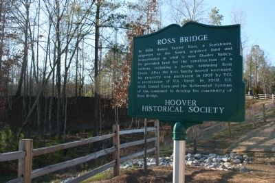
In 1858 James Taylor Ross, a Scotchman, migrated to the South, acquired land and homesteaded in what is now Shades Valley. He provided land for the construction of a railway, including a bridge spanning Ross Creek. After the Ross family moved . . . — — Map (db m27302) HM
The story of “steel drivin’ man” John Henry is one of America’s most enduring legends. The strong ex-slave became a folk hero during construction of the Columbus & Western Railroad between Goodwater and Birmingham. He drilled holes for . . . — — Map (db m22207) HM
The Depot was built by Richmond & Danville Extension Co. in 1883-84 following the completion of the Georgia & Pacific RR line between Birmingham and Atlanta, three years before the Town of Leeds was incorporated.
Richmond Terminal Co. operated . . . — — Map (db m22209) HM
This cemetery is owned by St. John Baptist Church in Edgewater and operated by Scott-McPherson Funeral Home, Inc. US Steel Corporation previously owned the area and it is historically associated with the Edgewater Mining Camp community established . . . — — Map (db m37221) HM
Trussville was settled between 1816 and 1819 by a few settlers from the Carolinas prior to Alabama becoming the 22nd state in December 1819. The First Baptist Church, Cahaba, was organized in 1821. Trussville’s first postmaster in 1833 was Arthur . . . — — Map (db m34338) HM
In April 1886, railroad prospectors were traveling up the Butahatchie Valley in Lamar County, Alabama, Moscow beat, and securing right of way for a railroad to be built that would connect Birmingham, Alabama and Memphis, Tennessee. In November . . . — — Map (db m96472) HM
The East Florence business area began in the industrial boom of the 1880s and 1890s and continued its development through the 1920s. Originally known as "Sweetwater", the small locally owned firms were established to serve the growing population . . . — — Map (db m35769) HM
In 1889, Dr. Alfred Davis Bellamy moved his Atlanta-based wagon manufacturing company to East Florence, near the northern bank of the Tennessee River. For Bellamy, East Florence was the perfect location for his burgeoning Florence Wagon Works. . . . — — Map (db m268972) HM
Side A
Tennessee Street along the north side of the square was originally part of Gaines’ Trace, a horse path laid out in 1807 under the direction of Capt. Edmund Pendleton Gaines of the U. S. Army. From Melton’s Bluff on the Tennessee . . . — — Map (db m29056) HM
Front
The Crescent was an exclusive train of Southern Railway (SR) and Alabama affiliates Western Railway of Alabama (WRA), Atlanta & West Point Railway (AWPR), and Louisville & Nashville Railway (LNR). Excepting SR, these . . . — — Map (db m98305) HM
At the Auburn train depot on February 16, 1861, Jefferson Davis reviewed the Auburn Guards, the first Confederate military company thus honored. Davis was en route to his inauguration as President of the Confederacy. The Auburn Guards were comprised . . . — — Map (db m74455) HM
Opelika A Railroad Town. Opelika's original name was Opelikan when the town was founded in the 1830s. In 1850, the name was respelled as Opelika. In 1851, the Montgomery & West Point Railroad Company extended its Montgomery to Opelika rail . . . — — Map (db m184077) HM
obverse
The Railroad Avenue Historic District was the downtown nucleus of Opelika when the city was incorporated as part of Russell County, Alabama in February, 1854. The city limits extended a mile in every direction from the Montgomery . . . — — Map (db m85336) HM
With orders from Gen. Sherman, Gen. Lovell Rousseau left Decatur with 2,700 cavalry, beginning his raid into East-Central Alabama. That raid ended successfully in Opelika July 19, 1864, after miles of track were destroyed along with other railroad . . . — — Map (db m75126) HM
The earliest buildings in the South Rail Road Avenue block between 9th and 10th Street were constructed by William O. Harwell around 1900 and were occupied by his agricultural supply store. His daughter, Alice Inez Harwell married Lum Duke who . . . — — Map (db m84735) HM
From the 1850s to the 1970s, the Louisville & Nashville Depot was located between Market and Washington streets. The building has been used as a dress ship, a photographer's studio, and in 2004 was remodeled for the Limestone County Archives. . . . — — Map (db m93878) HM
On Sept. 25, 1864 Gen. N.B. Forrest's Confederate cavalry, with Morton's battery of 4 guns, attacked and captured the Union fort near here. The fort consisted of a square redoubt, rifle pits, two blockhouses, and some frame buildings. It protected a . . . — — Map (db m60870) HM
Train #3 southbound, circa 1913. The wye (turnaround) is visible on the right. Because trains traveled with only one engine in the early railroad days and the tracks further south were under construction, a wye was necessary at Elkmont for . . . — — Map (db m93859) HM
Front The earliest settlers to this area moved across the Chickasaw boundary before 1810 and established the Sims and New Garden settlements. The area came to be known as Elkmont, for the once abundant elk, the Elk River and the "mount" on . . . — — Map (db m85426) HM
Soon after this scene was captured of Union troops rebuilding Sulphur Creek Trestle, one mile south of here, in early 1864, the ring of hammers was replaced by the thunder of cannon fire. By the time the smoke cleared, more than 240 men were dead in . . . — — Map (db m154183) HM
Mooresville's history began in 1805 when the first settlers arrived in the area and set up homesteads on lands occupied by the Chickasaw Indians. The Indians later ceded the land to the Federal Government and public land sales began in 1818. . . . — — Map (db m189567) HM
Fort Davis Railroad Depot
Macon County
The first Fort Davis Railroad Depot was constructed in 1892,
which was approximately the time that the Savannah-Americus-Montgomery Railroad came through the community.
The current building was . . . — — Map (db m161039) HM
In 1897 one of the first upright water
tanks in the U.S., and possibly the world
was built in Notasulga, Alabama. The water
tank supplied water for steam engines that
traveled through the area. When a steam
engine stopped for water, a boiler . . . — — Map (db m304215) HM
In July 1864, Union Gen. Wm. T. Sherman sent Maj. Gen. L.H. Rousseau
to Alabama with 2500 cavalry to cut the rail link remaining to
Confederates defending Atlanta: the West Point & Montgomery
Railroad. On 18 July, 3 Union units arrived at Chehaw . . . — — Map (db m223941) HM
There has been a settlement at and around the area presently known as Gurley since before the 1800s. Located in Madison County in in the rich agricultural, mineral and timber belt of northern Alabama, Gurley lies 16 miles east of Huntsville and 80 . . . — — Map (db m275318) HM
Located on land owned by John Gurley, pioneer settler, and named for him. His son, Capt. Frank B. Gurley, became a Confederate hero as a member of the 4th Ala. Cavalry. The settlement that developed around the water tank on Memphis and Charleston . . . — — Map (db m30574) HM
C.B. "Bill" Miller, of Miller and Miller, Inc., had a positive impact in all areas of the transportation industry across the State of Alabama. He has erected bridges, railroads, parks, pedestrian walks, airports, drainage, wastewater facilities, . . . — — Map (db m54247) HM
(Front):Historic Viduta
"Viduta"-derived from Spanish "vida" meaning "life"
In a time when yellow fever, malaria, and cholera threatened, Dr. Thomas Fearn and his brothers Robert and George were drawn by the cool air and medicinal . . . — — Map (db m27795) HM
Site of Hotel Monte Sano, built in 1887 by the North Alabama Improvement Company with the assistance of Michael and James O’Shaughnessy. The 233-room hotel opened on June 1, 1887 and served as a health resort and haven for famous visitors including . . . — — Map (db m27796) HM
The Monte Sano Railway ran from the Huntsville Depot up Monte Sano Mountain along what became Bankhead Parkway through Monte Sano State Park to the 19th century Hotel Monte Sano. The Baldwin Engine and three cars stopped at Laura’s View Station. The . . . — — Map (db m27856) HM
Memphis and Charleston Railroad Company Eastern Division headquarters in this passenger depot, adjoining yards and ships captured by Union Army April 11, 1862. Vital east-west Confederate rail link severed; C.S.A. soldiers imprisoned here. Depot . . . — — Map (db m85547) HM
Establish in 1856 as a shipping station on the Memphis and Charleston R.R., the town was platted on land owned by James Clemens and incorporated by vote of its citizens in 1869.
First officials included William R. Johnston, mayor, and five . . . — — Map (db m275777) HM
The Alabama Territorial Legislature established Marengo County in 1818. The “Town of Marengo” was then surveyed near the center of the county to serve as county seat. In 1824 lots were sold, and early French immigrants named the town Hohenlinden . . . — — Map (db m72971) HM
In the early days, Glen Allen was known as Stewart's Gap. Glen
Allen got its name from the last names of two engineers who
worked with the railroad company. In early 1889 lots were laid
out along the rail tracks using the railroad to serve as . . . — — Map (db m168048) HM
City of Guin, Alabama: The Early Years
In 1889, Dr. Jeremiah Guin gave land to the Kansas City, Missouri & Birmingham Railroad to allow completion of its Memphis to Birmingham railway. The rails connected at Dr. Guin's farm, about ¼ . . . — — Map (db m96796) HM
Retired from the Toulminville - To - Lafayette Street run in 1904.
Restored by W.C. Martin in 1964. Building was erected in 1969, under the administration of
Commissioners: Lambert C. Mims
Arthur R. Outlaw
Joseph N. Langan
Proj. . . . — — Map (db m172190) HM
The first submarine successfully used in warfare was completed at this site in 1863. Designed by James McClintock and Baxter Watson, and financed by Horace L. Hunley, it was built by W. A. Alexander at the Mobile machine shop of Park and Lyons. . . . — — Map (db m86244) HM
After the abolition of international slave trading in 1808, dealers transported slaves from all over the South into Mobile. On this site, Africans were sold as chattel to southern planters through public auction. Between auctions, a three-story . . . — — Map (db m86312) HM
In 1872 the Mobile and Alabama Grand Trunk Railroad
Company laid the first tracks to the town of Mount Vernon,
with daily service to Mobile. A year later, the company
extended their rail line north to the Tombigbee River - where a
ferryboat . . . — — Map (db m149305) HM
Original Historic Site of The Old Whistler Railroad Depot.
Where Famous Train Engineer Casey Jones was Based and Married Nearby — — Map (db m300538) HM
Original church built in 1867 on land deeded by Jacob & Mary Magee on August 25, 1864. Present edifice and rectory built in 1874. Famous railroad engineer, Casey Jones, baptized here on November 11, 1886. — — Map (db m148902) HM
Side 1
On Dec. 1, 1955, at Alabama State College (now Alabama State University) in a basement room in Councill Hall, the Montgomery Bus Boycott was planned and publicized after the arrest that day of Rosa Parks, who refused to give up . . . — — Map (db m91279) HM
Pickett Springs
Railroad building and amusement park development flourished in the post-bellum South. In 1880s, Western Railroad of Alabama opened Pickett Springs on site of William Harris’s plantation, “Forest Farm;” Harris’s daughter, Sarah, . . . — — Map (db m38900) HM
On December 1, 1955, Rosa Louis McCauley Parks was arrested on this site for refusing the order of city bus driver J. F. Blake to vacate her seat under the segregation laws of the Jim Crow era. She was taken to police headquarters at City Hall . . . — — Map (db m91286) HM
Only surviving residence of former Mayor E.B. Joseph. The Italianate cottage was built c. 1855 by Pickett Chauncey Smith, a merchant in antebellum Montgomery, and father-in-law of E.B. Joseph, who occupied the house from 1880 to 1885. Joseph served . . . — — Map (db m86426) HM
Side 1
The Domestic Slave Trade
Beginning in the seventeenth century, millions of African people were kidnapped, sold into slavery, and shipped to the Americas as part of the Transatlantic Slave Trade. In 1808, the United States . . . — — Map (db m86427) HM
The Lightning RouteIn 1886, Montgomery became the first city in the Western Hemisphere to convert an entire street railway system to electricity. The Capital City Street Railway Co. initiated electric trolley service on one mile of the street . . . — — Map (db m86468) HM
Few sheds of this type, once so much a part of the urban scene, remain. Designed by railroad engineers, it illustrates the beginnings of that technology which made possible the skyscrapers and bridges
of today. — — Map (db m94031) HM
In October. 1821, steamboat Harriett arrived at city wharf, introducing a new method of transporting goods as Montgomery became increasingly important market center for region. Until early years of 20th century Steamboats continued to ply river. In . . . — — Map (db m224806) HM
The ten bronze roundels displayed on this wall are a tribute to the
"foot soldiers" who toiled for 382 days during the Montgomery Bus
Boycott of 1955 and 1956. The roundels depict individuals who
were involved in, and events that occurred . . . — — Map (db m91276) HM
Union Station & Riverfront Park
Transportation center of Montgomery located in this area for many years. First steamboat, the "Harriet," landed nearby 1821. City wharf constructed at landing place 1823. First railroad, Montgomery & West . . . — — Map (db m86470) HM
Charlestown was developed by Charles Van Depoele, a pioneer in electric railway technology and inventor of the electric trolley pole. The first citywide electric streetcar system, the Capital City Street Railway or the Lightening Route ran parallel . . . — — Map (db m250889) HM
Side 1
Remount Depot
During World War I, in the summer of 1917 the U.S. Army opened a remount depot here to buy horses and mules for Camp Sheridan's 27,000-man 37th Division from Ohio. Despite the introduction of motor transport . . . — — Map (db m71340) HM
Of the various detachments that removed the Cherokee People from their home lands in the southeastern United States, three of them landed in Decatur at what became Rhodes Ferry Park. Due to the difficulty of navigating the Muscle Shoals portion of . . . — — Map (db m140846) HM
Public Buildings
1. Public City Hall
2. Decatur Police Station
3. Decatur/Morgan Co. Chamber of Comm.
4. Decatur Public Library
5. Federal Bldg./Post Office
6. Morgan County Archives
7. Morgan County Courthouse
8. Morgan . . . — — Map (db m103228) HM
The Old Decatur Historic District dates Back to the town's settlement in 1817; at that time it was called Rhodes Ferry Landing after Dr. Henry W. Rhodes, an early landowner who operated a ferry across the Tennessee River. In 1820, President . . . — — Map (db m103229) HM
In 1860, the Memphis and Charleston Railroad was the only east-west route through the United States south of the Mason-Dixon Line. Maintaining control of this rail line was essential to Confederate strategy. Union Brigadier General Ormsby Mitchell . . . — — Map (db m28262) HM
The Carrollton Short Line Railroad, authorized by the legislature in 1897, connected the Mobile & Ohio Railroad at Reform with the Pickens County seat. John Taylor Cochrane of Tuscaloosa, working with Carrollton citizens, completed that line in . . . — — Map (db m92644) HM
The Mobile & Ohio Railroad Company in 1897 announced plans to build a line from Artesia, Mississippi through Pickens County to Tuscaloosa and on the Montgomery. Leading citizens in Carrollton sought to persuade the company to bring the line through . . . — — Map (db m178594) HM
This area's first settlers arrived in the 1830s and established the Crossroads community at the intersection of the Columbus-Tuscaloosa and Vienna-Fayette stagecoach roads, one mile northeast of Gordo's present location on Highway 82. The name . . . — — Map (db m152577) HM
The South and North Alabama Railroad Company constructed the Helena Freight House & Depot about 1872 while repairing damage inflicted by Union raiders in 1865. The original location of the structure was just north of the present railroad . . . — — Map (db m76262) HM
At a crossroads, one mile south of Helena, a post office called Cove was established in 1849 and renamed Hillsboro in 1857. During the Civil War the South & North Railroad (the Louisville & Nashville Railroad) was constructed to just north of . . . — — Map (db m76243) HM
Constructed around 1890 to transport large deposits of minerals in the region. Iron ore, marble, limestone, and coal, the L&N Railroad also ran passenger trains daily. The L&N depot was built in 1909 directly behind where you are standing. It was . . . — — Map (db m79403) HM
Side 1
Wilton, a once prominent railroad town now sits nestled quietly in the southwest corner of Shelby County. Founding members were as follows: L. McMillen, L.W. Irwin, O. H. Bice, John Westley Little, Sam Vest, L. Cochran, and O. L. . . . — — Map (db m76246) HM
Post office established as Diana 1834
Name changed to Cropwell 1837
Masonic Lodge chartered 1857
In 1887 Birmingham & Atlantic R.R.
came to Cropwell — — Map (db m217724) HM
Ward Alabama came into being about 1910-13 as a result of the new railroad connecting the Gulf and the North.
Gaston, Alabama gave way to Cokes Chapel which gave way to Ward.
Ward High School was established with the first
graduating class in . . . — — Map (db m288027) HM
History of York
Legend has it that York began at a blacksmith shop called Old Anvil, located at a crossroads a few miles northwest of the present city. Circa 1833, early settlers of a site located east of modern-day York on the old . . . — — Map (db m89719) HM
Historical records indicate that DeSoto and his men, as they traveled the South in search of gold, were the first white men to see the Lincoln area. With the ceding of the Creek Indian Territory in 1837, the population of the area increased. The . . . — — Map (db m33282) HM
The district contains a collection of late-19th to mid-20th century commercial buildings representing over 60 years of Sylacauga's commercial history. On December 1, 1886, the Anniston and Atlantic Railroad became the first railroad to come through . . . — — Map (db m131719) HM
Here was northern terminus
of 60 miles of toll road
operated from Wetumpka.
Built of wooden boards.
Prior to railroads this was
an important artery of travel.
Chartered to connect navigable
parts of the Alabama, Coosa,
and Tennessee River. — — Map (db m288230) HM
Anticipating the construction of a railroad through the country hamlet of Youngsville, Griffin Young in 1860 hired W. H. Whatley to survey a portion of his property and lay it off in forty-eight town lots. In the plan two acres were reserved for use . . . — — Map (db m28544) HM
The transformation of Youngsville from a country hamlet to a market town can be traced from the arrival of the railroad. The Savannah and Memphis Railroad was completed from Opelika to the east side of the Tallapoosa River at Sturdivant in 1872. . . . — — Map (db m28653) HM
Following the Creek Cession in 1832, settlers, mostly from Georgia and the Carolinas, occupied this section of the Creek Nation. Among the first settlers was James Young who purchased land a half-mile west near a trading post called Georgia Store. . . . — — Map (db m28658) HM
The pipe marked DL & CO 1889 for Dennis Long and Company was unearthed in Cahaba Heights. Dennis Long was a native of Londonderry, Ireland who began the manufacture of cast iron pipe prior to the Civil War in Louisville, Kentucky. Long won and lost . . . — — Map (db m107495) HM
During his term our state moved from frontier to urbanity. The University of Alabama was officially opened. Construction was begun on our first canals and railroads, supplementing existing steamboats and unpaved roads. The Choctaws exchanged their . . . — — Map (db m29023) HM
This wooden and steel truss bridge was constructed for the Mobile and Ohio Railroad in 1898 by civil engineer Benjamin Hardaway, an 1887 graduate of The University of Alabama and former Tuscaloosa City Engineer. Originally 135-feet high with a . . . — — Map (db m28992) HM
In the mid-1820s, founding settler Eldridge Mallard
established the Byler Toll Road central collection
booth near the artesian springs along the Byler Road,
leading to the founding of the Camp Springs
settlement. Named by General Andrew . . . — — Map (db m293278) HM
Ellisville logging camp had it's beginnings as a
turpentine still 5 miles west of Yarbo off the Chatom
Bigbee road around 1911. The operation was expanded
greatly after 1919 when Ingram Day Lumber company
bought the sawmill in Yarbo. Ingram Day . . . — — Map (db m286137) HM
The history of Fruitdale Brethren Church can be traced
back to the charter of the Mobile and Ohio Railroad, after
which The Brethren School Company of Covington, Ohio,
purchased the land. The church was organized on April 18,
1896. The family of . . . — — Map (db m285578) HM
Front:
This area was Choctaw Indian country before the arrival of settlers moving south and west in this new nation. The first settlement, known as Arnold, was located one mile north of the present town center. Mr. Charley A. Sheldon from . . . — — Map (db m47618) HM
(Side 1)
The Cherokee Indians were here first. They lived under the bluffs, near an area called the “division of the waters.” Richard McMahan established the first permanent settlement here in1820. John Byler completed the . . . — — Map (db m80558) HM
By 1887, the growing number of travel options
created competition for the Byler Road. The Sheffield
and Birmingham Railroad completed a line from
Sheffield as far south as Natural Bridge.
The railroad crossed the Byler Road in several
places, . . . — — Map (db m309081) HM
In 1914, the Alaska Engineering Commission designated the north bank of Ship Creek as the site of main railroad construction camp. The town of Anchorage began as a railroad construction settlement at the mouth of Ship Creek. For many years the . . . — — Map (db m260158) HM
On November 23, 1920 the Alaska Engineering Commission rel[i]nquished responsibility for local government. Anchorage incorporated into a civilian run city.
4th Avenue was still the main commercial street. Even though the population remained . . . — — Map (db m260220) HM
“The Iron Trail” by Rex Beach describes these events and this area.
This tunnel was hand cut into the solid rock of Keystone Canyon and is all that is left of the “railroad era” when nine companies fought to take advantage of the short route . . . — — Map (db m49609) HM
From 1911-1938 the Copper River & Northwestern Railway was the lifeline for the Kennecott mines. Nicknamed the “Can't Run & Never Will” by its skeptics, the CR&NW overcame incredible challenges in its construction and operation.
Blasted and . . . — — Map (db m173891) HM
“In constructing high trestles and in laying steel track on beds of ice and snow, storms, high winds, and extreme cold tried the patience and fidelity of the strongest and most faithful.” — Cordova Daily Alaskan April 1, . . . — — Map (db m173892) HM
The Copper River & Northwestern railroad lines (nicknamed the "Can't Run & Never Will") were built in 1908-1911, against nearly impossible odds with subzero temperatures and impenetrable
snow. The two-hundred mile route connected the coastal . . . — — Map (db m255386) HM
These days, you'll have a hard time sighting Curry - a deserted station about 100 miles south of here, in the Talkeetna Mountains, But in 1923, it would have been hard to miss; Curry was where you spend the night - or lingered longer - as you . . . — — Map (db m283126) HM
During World War II, thousands of servicemen left the war behind and spent a week in the park.
When Japanese forces attacked the Aleutian Islands in June 1942, vacation travel to Alaska ground to a halt. In the absence of full . . . — — Map (db m283780) HM
How did you imagine the park before you had seen it for yourself? In years past, travelers' expectations were shaped by railroad brochures
that touted the marvels of Alaska and portrayed the park as
a wonderland. The words below are from a . . . — — Map (db m283937) HM
1915 Construction begins on the Government Railroad, later renamed the Alaska Railroad.
1917 Mount McKinley National Park is established. Enterprising pioneers have already built homesteads outside park boundaries, near . . . — — Map (db m283782) HM
Laying rail through a subarctic wilderness was no walk in the park.
The railroad builders were constantly reminded
that nature was beyond their control. South of
Anchorage, avalanches buried the route. In the
Nenana Canyon, . . . — — Map (db m283580) HM
As the number of ways to get to the park grew, so did the number of visitors.
If you wanted to visit the park prior to 1957, rail travel was not only a good option, it was about your only option. A few visitors arrived by chartered . . . — — Map (db m283550) HM
The first depot established in 1922, was a converted boxcar. It had once belonged to the Tanana Valley Railroad — a Fairbanks-area outfit that became part of the Alaska Railroad. Presumably, the depot arrived by rail. It did double duty as the . . . — — Map (db m283266) HM
The fortunes of the park and the railroad have long been linked.
It could be said that the coming of the railroad was a catalyst for the creation of the park. In January 1917 Stephen R. Capps of the U,S. Geological Survey reported that . . . — — Map (db m283594) HM
The train track along the Healy Canyon wall provides an exhilarating view down to the Nenana River below. Imagine the challenge of constructing this grade in 1921. Three tunnels at the south end of the canyon made the job a little easier by . . . — — Map (db m71361) HM
11101 entries matched your criteria. Entries 101 through 200 are listed above. ⊲ Previous 100 — Next 100 ⊳