World War II, Marshall Islands Operation, Jan. - March 1944 •
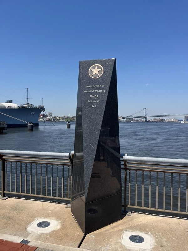
World War II, Asiatic Pacific Raids, Feb. - May 1944 •
World War II, Hollandia Operation, April - May 1944 •
World War II, Marianas operation, June - August 1944 •
World War . . . — — Map (db m220985) WM
Donated by the Bantivoglio Family to the City of Camden to memorialize the City for its deep roots in world-wide commerce and shipping.
The Bantivoglio Family owned and operated Camden Iron and Metal which was headquartered in Camden, NJ for . . . — — Map (db m146668) HM WM
The Benjamin Franklin Bridge, originally named the Delaware River Bridge, opened on Jul 1, 1926, after four years of construction. Commuter rail service was added in 1936. At the time of completion, the Benjamin Franklin Bridge was the world's . . . — — Map (db m146412) HM
A Lasting Legacy
The Delaware River played a fundamental role in the development of Camden. Ferries to and from Philadelphia in the 1600s led to settlements along the river. By the 20th century, industrial uses dominated the waterfront, . . . — — Map (db m220915) HM
Ferry service between Camden and Philadelphia began as early as 1688. By the 1870s, up to six separate ferries operated daily between Philadelphia and Camden. Several rail lines began and ended at the ferry terminals on both sides of the Delaware . . . — — Map (db m220916) HM
Cooper Street has been one of Camden's most important streets for over two centuries. Known in 1765 as the Middle Ferry Road, it became Cooper Street in 1773 when Jacob Cooper laid out the town in Camden. The street takes its name from the Cooper . . . — — Map (db m208376) HM
African slavery in New Jersey began with early European settlement. By 1766, circa 800 captive people had been sold here at the Federal Street Ferry and two other nearby ferry landings. In Africa, approximately 24 million captured men, women and . . . — — Map (db m208367) HM
Prior to the 1800s ferries and stagecoaches were critical to the transport of passengers in and out of the City of Camden, and this transportation network continued to grow during the 19th century. Once the Camden and Amboy Railroad (C&A) had . . . — — Map (db m208368) HM
African slavery in New Jersey began with early European settlement. By 1766, circa 800 captive people had been sold here at the Coopers Point Ferry and two other nearby ferry landings. In Africa, approximately 24 million captured men, women, and . . . — — Map (db m220914) HM
Although efforts to build a bridge connecting Camden with Philadelphia began in 1818, it wasn't until 1926 that a bridge was completed. Ferries provided transportation across the Delaware River as early as the 1680's and contributed to the growth . . . — — Map (db m190722) HM
This redevelopment site at the corner of N. Fourth and Cooper Streets was laid out as building lots in the 1770s. The photo below shows some of the residences that lined the south side of Cooper Street in the vicinity of this site.
This . . . — — Map (db m220516) HM
A bridge crossing the Cooper River was built in 1928 on this location (Structure No. 0405-153) as part of the original park construction. The bridge was replaced in 2014 as part of the roadway improvements along Route 30/130. The design of the . . . — — Map (db m146687) HM
Ship’s Bell from S. S. Cape May Built 1943 Retired 1969 Length 417’9” Beam 60’ Draft 27’6” Crew 49 Presented to the city by U. S. Maritime Administration in 1974 Served in European war zone in World War II Later served . . . — — Map (db m15600) HM
Primary seacoast lights were located to warn mariners of their proximity to land, the presence of navigational dangers, and to help set their course. By 1852, however, lighthouses and lightships often looked so much alike that it was difficult to . . . — — Map (db m114571) HM
During the late 18th century, the first coastal defenses built in the United States were earthen forts constructed on high points near important harbors. Soon thereafter, star-shaped stone forts were built in the years leading up to the War of 1812. . . . — — Map (db m34612) HM
From the time the current lighthouse was built in 1859 to the time it was electrified around 1933, four keepers, their assistants, and their families lived and worked on this landscape by the sea.
The keepers and their periods of service . . . — — Map (db m114569) HM
Primary seacoast lights were located to warn mariners of their proximity to land, areas of danger, and to help set the course. Sandy Hook and Navesink Twin Lights marked the entrance to New York Harbor. Cape May and Cape Henlopen Lighthouses . . . — — Map (db m206412) HM
This boat represents an integral part of U.S. Lifesaving Service and U.S. Coast Guard history. It is a 26-foot lifesaving boat, "Monomoy" Class, circa 1800s-1930s. This class of rescue boat originated in New England and was regularly used in Cape . . . — — Map (db m206415) HM
This structure was built in 1893 to house the kerosene used to power the light. Until 1893, the Lighthouse’s oil was stored in the vestibule house at the entrance to the tower. Moving it to a separate building reduced the risk of fire in the . . . — — Map (db m114573) HM
This structure was built in 1893 to house the kerosene used to power the light.
Lighthouses were generally powered by Sperm Whale oil until its price rose dramatically in the 1850s. In the mid-1870s, kerosene, which was less expensive than . . . — — Map (db m206416) HM
Pitch Pine (Pinus rigida) is the dominant tree of the New Jersey Pine Barrens and was a major source of pitch and timber used in ship building. It was also used for railroad ties due to its high resin content which preserves it from decay. Pitch . . . — — Map (db m191072) HM
Remains of experimental concrete ship. One of twelve built during World War 1. Proven impractical after several Trans-Atlantic trips because of weight. In 1926, the Atlantus was purchased by Colonel Jesse Rosenfeld to be used as a ferry dock in . . . — — Map (db m34608) HM
This large Southern Red Oak tree is known for its turkey foot shaped leaves. The woodlands of Bradner's Run host a variety of oaks. Oak trees offer a wide variety of natural and cultural resource benefits. The acorns are an important food source to . . . — — Map (db m191070) HM
Construction of the Cape May Lighthouse is being supported in part by a National Maritime Heritage grant administered by the National Park Service, Department of the Interior.
This lighthouse was built in 1859 by the Army Corps of Engineers, . . . — — Map (db m206417) HM
What Happened in South Cape May?
From the mid-1800s to the 1940s, South Cape may was a quaint vacation town complete with hotels, bathhouses, a railroad and a popular beach.
Over time, storms took a heavy toll on the town and the . . . — — Map (db m209365) HM
This large double trunk Tulip Poplar (Liriodendron tulipifera) produces tulip shaped flowers that are large, brilliant, and numerous. Their color is greenish yellow with dashes of red and orange. The flower's red base guides bees to the flower's . . . — — Map (db m191067) HM
For some 180 years, a lighthouse beacon has stood here at the southern tip of New Jersey, guarding the entrance to Delaware Bay. The present tower was constructed in 1859. Standing 157½ feet tall, it is the third lighthouse on this site, . . . — — Map (db m114572) HM
For almost two centuries, a lighthouse beacon has stood here at the southern tip of New Jersey, guarding the entrance to the Delaware Bay. The present tower was constructed in 1859. Standing 157½ feet tall, it is the third lighthouse on this . . . — — Map (db m206413) HM
Bradner's Run is a freshwater stream which runs along the southern edge of Historic Cold Spring Village. It travels under the Garden State Parkway and then meets the salt marsh of the intracoastal waterway. It is named for John Bradner, first . . . — — Map (db m191078) HM
Bradner's Run is a freshwater stream which runs along the southern edge of Historic Cold Spring Village. It travels under the Garden State Parkway and then meets the salt marsh of the intracoastal waterway. It is named for John Bradner, first . . . — — Map (db m191071) HM
Whales and dolphins, known collectively as cetaceans, visit New Jersey’s coastal waters and the Delaware Estuary during the warmer months. Their migratory movements may be a reflection of the changing locations of their prey: fish, crustaceans, . . . — — Map (db m43975) HM
Most shore bathers soon realize the back-and-forth motion of the waves breaking on the shore not only stirs the sand but also persistently carries them along the beach. This unseen force is called a "longshore" or "littoral" current. In general, . . . — — Map (db m206418) HM
In 1631, officers of the Dutch West India Company ship "The Whale" acquired 16 square miles of land, including this site, from the Lenape "to carry on the whale fishery [and] cultivation of grains and tobacco."
New England and Long Island Whalemen first settled Cape May on the Delaware Bay Shore about 1685. To the sandy bluff called Town Bank came Joseph Willdin and his wife, Hannah Gorham, grandchild of John Howland, the Mayflower Pilgrim. — — Map (db m209367) HM
Primary seacoast lights were located to warn mariners of their proximity to land, the presence of navigational dangers, and to help set their course. By 1852, however, lighthouses and lightships often looked so much alike that it was difficult to . . . — — Map (db m46293) HM
Several Life-Saving Service/Coast Guard station structures have served the Hereford Inlet area. The original 1849 Life-Saving Station provided assistance to stranded steamers and coal traders using the coastal waterways. It was moved further . . . — — Map (db m209300) HM
This plaque was presented on June 3, 2006 by the New Jersey Sarah Soper Chapter of the National Society Colonial Dames XVII Century to recognize the unique architecture of the building and its importance as an aid to navigation. — — Map (db m46294) HM
After the Lighthouse was moved to this spot in 1913, it continued to guide mariners and replaced by a steel tower with an automated beacon in 1964. When the State of New Jersey leased the Lighthouse to the City of North Wildwood in 1986 the . . . — — Map (db m209309) HM
Work was completed in the spring of 1874 at this site, the original location of the Hereford Inlet Lighthouse. The fourth-order Fresnel Lens in the tower was illuminated for the first time on May 11, 1874. Erosion on the south side of the Inlet, due . . . — — Map (db m118223) HM
Designed by Paul J. Pelz, architect of the US Library of Congress this fourth order lighthouse was constructed for the sake of mariners to mark the entrance to the Hereford Inlet. Listed on the New Jersey Register of Historic Places, 1976. Listed on . . . — — Map (db m209305) HM
This is the top of the rudder post from the 329 foot iron hull bark Sindia. On December 15, 1901 the Sindia was grounded at 17th Street beach. The US Lifesaving crew from this station, under the command of keeper John Mackay Corson, . . . — — Map (db m208354) HM
Owned by Anglo American Oil; Captain Allen McKenzie Built in 1887 by Harland & Wolf, Belfast, Ireland.
Four masted steel bark Length 329 ft-depth of hold 26 ft Breadth 45 ft-Net Tonnage 2929
The Sindia en route from . . . — — Map (db m92393) HM
The District, bounded by 3rd and 8th Streets and Central to Ocean Avenues, has been placed on both the State and National Register of Historic Places by the United States Department of the Interior.
On October 20, 1879, Simon Lake, Ezra B. . . . — — Map (db m208353) HM
Preservation made possible by
The City of Ocean City
with a matching grant from the
Garden State Historic Preservation Trust
Administered by the
New Jersey Historic Trust
2010
The U.S. Life-Saving Service was founded in . . . — — Map (db m208355) HM
In dedication and remembrance to the U.S. Navy Seamen who gave their lives aboard the U.S.S. Arizona at Pearl Harbor December 7, 1941 — — Map (db m153621) WM
The Fish Alley Memorial Project and the people of Sea Isle proudly honor our commercial fishermen for their contributions to the community and to America.The strength and character of these outstanding men shaped our city, in the face of tremendous . . . — — Map (db m247336) HM
Vintage House 1895 Stone Harbor
The Historic Tatham Life Saving Station Circa 1895
This property has been listed in the National Register of Historic Places
By the United States Department of the Interior — — Map (db m97832) HM
Design: Surfboat style
Rescued: In 2006 from a location in Brewster, Cape Cod, Massachusetts by Stone Harbor Post #331 American Legion members
History: Believed to be a surfboat that saw service at Chatham, Cape . . . — — Map (db m246915) HM
A causeway was built here in the 1790s establishing a new overland route. By the 19th century Dennis Creek Landing became a major shipbuilding center on the Delaware Bay. Many homes in South Dennisville still reflect the architecture that was seen . . . — — Map (db m68283) HM
The Central Railroad of New Jersey built this long complex of 30 sheds in 1904 to process oysters that were harvested from the Delaware Bay. Originally, oysters were shipped in their shells via the railroad. Shucking, or removing oysters from their . . . — — Map (db m64333) HM
The Maurice River watershed (pronounced Morris) is an area of 386 square miles that includes part of the Pinelands National Reserve, other pine, cedar and maple woodlands and agricultural lands, as well as, urban and suburban properties. The river . . . — — Map (db m64497) HM
The Maurice River and its tributaries to the Delaware Bay have played a significant role in Southern New Jersey’s cultural landscape and shaped its diverse people—generation after generation.
Its resources, particularly fish and shellfish, . . . — — Map (db m64337) HM
The Schooner AJ MEERWALD is on the National and New Jersey Registers of Historic Places and is representative of an important vessel type, the “new style” Jersey oyster schooner. The “old style” schooner had a clipper bow . . . — — Map (db m64340) HM
The New Jersey Coastal Heritage Trail Route is a “park in the making”—an idea becoming a reality. Many of its sites are available for you to visit. When complete, the Trail will link numerous natural and cultural landmarks into a . . . — — Map (db m64491) HM
The East Point Lighthouse guards the eastern shore of the Maurice River Cove. This lone sentinel once provided hundreds of Delaware Bay oyster schooners with a guiding light to the ports at Port Norris and Port Elizabeth. Constructed in 1849, it . . . — — Map (db m68280) HM
Primary seacoast lights were located to warn mariners of their proximity to land, the presence of navigational dangers, and to help set their course. By 1852, however, lighthouses and lightships often looked so much alike that it was difficult to . . . — — Map (db m68281) HM
The East Point Lighthouse was built in 1849 to guide boatmen into the mouth of the Maurice River, about one half mile to the north. The lantern sits atop the two story brick building, 48 feet above sea level, and is visible for about 7 . . . — — Map (db m68285) HM
Congress passed the National Wild and Scenic Rivers Act in 1968 to protect selected free-flowing rivers with outstanding natural, cultural and recreational values. The Act promotes conservation and good stewardship of these streams and their . . . — — Map (db m64430) HM
Captain Joseph Buck, a veteran Revolutionary War officer and commandant of the Cumberland County Militia, stood on these riverbanks in the early 1790s and reviewed his troops. As time went on, he foresaw a new city of manor homes, lumber mills and . . . — — Map (db m153758) HM
Adolph A. Phillips
Water tender U.S. Navy.
Born Jan. 23rd, 1896
Died torpedo boat Jacob Jones,
sunk at sea Dec. 7th, 1917.
Foreign Waters U.S.N. — — Map (db m153794) WM
Corp. Charles Phillips
Co. A. 4th Pioneer U.S. Inf.
Born March 13th, 1893.
Died disease board ship
Oct. 5th, 1916.
French Harbor. — — Map (db m153820) WM
Lieut. Grady R. Roberts
Medical Corps U.S. Navy,
Born Aug. 22nd, 1893.
Died disease Troopship Kroonland.
Feb. 5th, 1919.
New York City.
— — Map (db m153815) WM
Owned by 5 generations of Hendricks
Supplied copper sheeting for
“The Demologus” - First U. S. steam war vessel in 1814
“The Savannah” - First steam propelled vessel to cross Atlantic in 1818
. . . — — Map (db m94441) HM
At this location the canal crossed Second River on a wooden aqueduct. The aqueduct and canal's five-foot depth made this a popular summer diving and swimming spot for Bloomfield's youth. — — Map (db m47151) HM
Mater Christi Council 3352
Knights of Columbus
Dedicates this monument
October 10, 1992
to commemorate 500 years of
evangelization in the Americas
"Admiral of the Ocean Sea"
whose faith and courage of conviction
made his . . . — — Map (db m146775) HM
In commemoration First Round the World Voyage without navigational instruments by Marvin C. Creamer Departed December 15, 1982 Returned May 20, 1984 — — Map (db m20046) HM
The Tinicum Rear Range Lighthouse began operation on the evening of December 31, 1880. The lighthouse is a steel skeletal structure standing 85 feet tall with 112 steps leading from the neoclassical pavilion at the base of the tower to the lantern . . . — — Map (db m69773) HM
The Maxwell House Coffee Plant stretched along Hoboken's waterfront from Tenth to Twelfth Streets. It was a marvel of its time, the largest coffee processing plant in the world, and a local landmark. Before the plant was built in 1938-39, part of . . . — — Map (db m6880) HM
John Cox Stevens, an outgoing member of Hoboken's founding family and avid boater, organized the New York Yacht Club (NYYC) on July 30, 1844, and served as its first Commodore. He built the first clubhouse on this site at the foot of Tenth Street. . . . — — Map (db m6882) HM
Floating clubhouses for boat clubs and a floating public bath lined the waterfront in the late 1800s. The Valencia was on of the larger, more impressive buildings. Except for one, all were gone by the early 1900s as the waterfront industrialized. . . . — — Map (db m242088) HM
American Export Lines used Piers A, B and C for both passenger and cargo ships from the 1950s to about 1970. It was the last major company to use the piers; Hoboken’s era as a working seaport was ending due to a shift to containerized shipping, . . . — — Map (db m242155) HM
Hoboken’s founding father, Colonel John Stevens, designed an iron-clad warship in 1813 that his surviving sons attempter to build starting in 1843 in a drydock just south of Second Street near Hudson Street. Known as the Stevens’ Battery, it was . . . — — Map (db m242216) HM
Two major German passenger lines made Hoboken their American homeport from the 1870s to 1914: Hamburg-America Line and North German Lloyd Steamship Co. Their ocean liners, some of the largest and finest of the era, occupied six piers from Newark . . . — — Map (db m242257) HM
The Hoboken waterfront is the home of a unique intermodal transit hub with commuter train, light rail, ferry, bus and subway service, plus taxis! It has connected the city to our region and New York since the 19th century. Centered at the restored . . . — — Map (db m242307) HM
On July 30, 1916, the Black Tom munitions depot exploded, rocking New York Harbor and sending sleeping residents tumbling from their beds.
The noise of the explosion was heard as far away as Maryland and Connecticut. On Ellis Island, terrified . . . — — Map (db m126348) HM
On the foggy, drizzly morning of June 13, 1958, Morris Pesin (1911-1992) made his historic 8 minute canoe trip to the Statue of Liberty with a Jersey Journal reporter to dramatize the close proximity of the Jersey City shoreline to Ms. . . . — — Map (db m126346) HM
In Memoriam
U.S.S. Maine
Destroyed in Havana Harbor
February 15, 1898
This tablet is cast from metal recovered from the U.S.S. Maine
Presented to the People of
Jersey City, N.J.
By
General Joseph Wheeler
Post No. 4 A.V.F.S. . . . — — Map (db m6102) WM
In 1822 George P McCulloh, a Morristown businessman conceived the idea for the Morris Canal.
The canal would cross the State of New Jersey from the Hudson River at Jersey City to the Delaware River at Phillipsburg.
Rising a total of 914 . . . — — Map (db m239442) HM
Still existing today are the remnants of the Morris Canal, an artificial waterway constructed in the 19th century to connect the New Jersey counties between the Hudson and Delaware Rivers.
You Can Still See
The Sugar House, located just . . . — — Map (db m239444) HM
The building standing on the other side of the Morris Canal Big Basin is the Central Railroad of New Jersey Terminal. Built in 1889, the complex represented the greatest concentration of rail facilities in the New York Harbor area during that . . . — — Map (db m239445) HM
The Morris Canal was an engineering marvel. Created by manual labor, it was mainly intended to transport coal from Pennsylvania's anthracite coal fields to northern New Jersey's industries.
In 1831, the canal operated from Phillipsburg on . . . — — Map (db m239391) HM
By the late 1850s, the original canal basin (the "Little Basin") proved to small to handle the growing canal traffic. To the south of it, the Big Basin was constructed in 1859. Canal traffic continued to increase during the Civil War years and . . . — — Map (db m239451) HM
The Morris Canal's original shipping basin was constructed here after the 102-mile-long canal reached Jersey City in 1836. The canal, built between 1825 and 1836 and from Phillipsburg on the Delaware River to Jersey City, transported chiefly . . . — — Map (db m239449) HM
Zum Andenken An Seine Indem Brande
In Hoboken Am 30ten Juni, 1900
In Treuer Pflichterfüllung Gebliebenen Angestellten
Der Norddeutsche Lloyd.
( translation )
In Memory of the Fire
In Hoboken on the 30th of June, 1900
Employees . . . — — Map (db m195946) HM
Access to the Global Marketplace
Weehawken's history was influenced by two geographic features: the Hudson River and the Palisades. The town's location along the river provided a tremendous economic trade opportunity as it facilitated access . . . — — Map (db m88426) HM
A man-made dam has been continuously harnessing the Musconetcong River at this location for over 250 years, influencing the settlement of the region and providing visitors and residents of Finesville with a connection to its historical origins as an . . . — — Map (db m89614) HM
The Union Forge Heritage Association welcomes you to Lake Solitude and Taylor Falls
With the depletion of natural resources that provided energy to power the adjacent Iron Works, Lake Solitude was constructed by the Taylor Iron and Steel . . . — — Map (db m37041) HM
Lake Solitude Dam (also known as the Taylor Dam) was constructed in 1858 across the South Branch of the Raritan River to provide hydro-power and hydro-electric power to Taylor Iron and Steel Company.
The original falls structure (spillway) was . . . — — Map (db m91857) HM
Dug by hand, mostly by Irish immigrants, the 66 mile D & R Canal was completed in 1834. 18 feet wide and 8 feet deep, the canal originally had 14 locks to raise and lower boat traffic
The D & R Canal operated as an inland waterway between the . . . — — Map (db m191190) HM
The outlet lock at this location was built to allow canal boats to pass between the Delaware & Raritan Canal and Pennsylvania's Delaware Canal. Canal boats loaded with coal from the Lehigh Valley would come down the Lehigh Canal to Easton, . . . — — Map (db m100644) HM
423 entries matched your criteria. Entries 101 through 200 are listed above. ⊲ Previous 100 — Next 100 ⊳