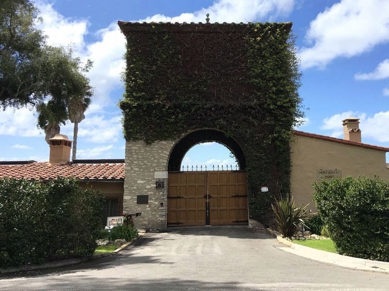
Edward Walker Harden married Ruth Isabel Vanderlip in 1903, in Chicago. They built the gatehouse, as it stands today, in 1926. Gordon Kaufmann was the architect, and the Olmsted Brothers designed the landscaping.
This imposing structure is of . . . — — Map (db m155773) HM
Early in World War II, the United States was reeling from Japan's attack on
Pearl Harbor and moved to augment the defense of San Francisco Bay from
enemy ships. Base end "fire control” stations proliferated along the coast in
those fearful times. . . . — — Map (db m190257) HM
Battery Alexander, fully armed by 1906, mounted eight 12-inch mortars designed to fire shells in a high arc - up and then down onto the decks of enemy battleships. Low-trajectory gunfire from nearby batteries, aimed close to the enemy's waterline, . . . — — Map (db m102819) HM
Never named because it was never finished, this battery was designed for the biggest, most powerful guns ever used by the United States military - 16-inch caliber weapons that fired 2,100-pound shells and could hit ships 26 miles out to sea. . . . — — Map (db m102778) HM
Battery Mendell's mission was to keep enemy warships farther from San Francisco's harbor than any of the earlier coastal defences were equipped to do. Built in 1905, the battery was positioned as far west on the headlands as possible and armed with . . . — — Map (db m102829) HM
The Marine Mammal Center is built on the site of the former Nike Missile Launch Area, SF 87L. In the 1950s, the army constructed two batteries in the Marin Headlands equipped with surface-to-are missiles, one near Fort Cronkhite and a second across . . . — — Map (db m102832) HM
Despite its imposing appearance, Construction 129 was never used - or even completed. It was to have been armed with 2 guns having massive, 16" diameter barrels. Each weapon weighed almost 1,000,000 pounds and could accurately fire a 2,100 pound . . . — — Map (db m102784) HM
For the first three-quarters of the 20th century, the Marin Headlands were fortified with weapons that evolved from cannon to nuclear warheads. The guns became more and more powerful, able to hit warships miles out to sea. Antiaircraft guns appeared . . . — — Map (db m102828) HM
Explore Battery Alexander
Battery Alexander
Built in 1901, the concrete coastal defense installation in the grove of trees behind the restroom held mortars that could fire 12-inch diameter shells in a high arcing path to penetrate the . . . — — Map (db m232187) HM
Golden Gate National Recreation Area
From Roundups to Radar
A sprawling Mexican rancho, where vaqueros (cowboys) herded cattle, encompassed this valley and its surrounding hills during the mid-1800s. Cattle roundups on the beach . . . — — Map (db m232185) HM
Built in 1911, this concrete barracks building could house 686 men. By WW II, Fort McDowell has quarters for about 4,500 soldiers, including fourteen additional wooden barracks that once stood between the baseball field and this 600-man barracks. . . . — — Map (db m69276) HM
A great morale builder, Fort McDowell’s bowling alley opened in 1944, sporting six lanes. Fort McDowell’s bowling teams – the “Jail Birds,” “Brass Hats,” and the "McDowell Mermaids” competed against teams from . . . — — Map (db m69299) HM
Constructed 1876
This building served as a place of worship and a school for the post’s children. The modest one-story building is a good example of vernacular church architecture from the 1870’s — — Map (db m203670) HM
Battery Ledyard, built in 1899, was one of three Angel Island batteries installed to defend San Francisco Bay. Located at Point Knox, it was armed with two five-inch wire wound guns. Battery Ledyard was named for Lt. August C. Ledyard, 6th Infantry, . . . — — Map (db m69251) HM
The Post Exchange, or PX, was built in 1910 to be a “one stop shopping place” for soldiers at Fort McDowell. Soldiers purchased clothing toiletries, and other supplies here. The PX also offered a restaurant, soda fountain, barbershop, . . . — — Map (db m69279) HM
The Guard House served as headquarters for the Officers of the Guard and the Sergeant of the Guard, and as quarters for soldiers assigned to guard detail. Guard duty could last a day, a week, or longer. Guards patrolled their post for 24-hour . . . — — Map (db m316214) HM
Enlisted men enjoyed few privileges and even fewer comforts at Camp Reynolds. Officers lived in the houses lining the parade ground, with the Post Commander closest to the water. Soldiers lived in barracks opposite officer’s row. One comfort the . . . — — Map (db m311968) HM
Five two-story barracks once lined this parade ground. Built between 1864 and 1874, each was designed to hold one infantry company. When housing was short, canvas tents filled the parade grounds to shelter soldiers from the wind and rain. — — Map (db m203778) HM
The Army used “mule power” on the island until the 1930s to haul supplies and quarried rock. They pulled graders, mowing equipment, and garbage wagons. Soldiers stabled and cared for the mules in this barn. — — Map (db m203683) HM
If you listen carefully, you can hear the crack of a bat and soldiers cheering as a Fort McDowell “Indian” rounds third base and heads for home – Cole Field. The ball park was home to the men’s baseball team, the “Indians,” and the women’s softball . . . — — Map (db m316219) HM
During WW I and WW II, Fort McDowell served as a Recruit Depot and later as an overseas Discharge and Replacement Depot. While some soldiers were stationed at Fort McDowell, others were here for only a week before being shipped overseas. During . . . — — Map (db m69280) HM
In 1863, Civil War was raging in the East and the threat of Confederate ships sailing into San Francisco Bay was real. The United States Army responded by sending Company B of the 3rd Artillery to establish Camp Reynolds as an artillery post on . . . — — Map (db m69250) HM
General John C. Fremont, 1813-1890. A noted military man, explorer, topographer, senator & businessman, Fremont was also a miner. He settled in Mariposa County living just outside Bear Valley. He operated the Josephine, Pine Tree & Princeton mines . . . — — Map (db m5783) HM
Established in this vicinity June 11, 1857 by 1st Lieutenant Horatio Gate Gibson, 3rd Artillery, later Brigadier General, US Army. Named by Gibson in honor of his former company commander, Braxton Bragg, later General, C.S.A. Abandoned in October . . . — — Map (db m10585) HM
The last remaining structure and once the original quartermaster’s storehouse and commissary of Fort Bragg Military Post 1857-1864, then located near Laurel and Redwood Avenues. — — Map (db m10586) HM
For the two million servicemen and women who passed through Fort Ord, the entertainment center that once occupied this site provided welcome relief from rigorous military training. The Soldier’s Club, later renamed Stilwell Hall, featured a huge . . . — — Map (db m68882) HM
From World War II until Fort Ord’s closure in 1994, there dunes echoed with the sound of small arms fire. Rifle and machine gun ranges here gave thousands of U.S. Army Infantrymen the marksmanship skills needed to serve their nation in times of both . . . — — Map (db m68885) HM
On November 20, 1818, in the closing years of the Spanish Era, Capitan Hippolyte Bouchard entered Monterey Bay with two ships, flying the flag of the United Provinces of the Rio de la Plata, Argentina. The next day, one ship attacked the Spanish . . . — — Map (db m66555) HM
Site of a Spanish fort constructed in 1792 to protect the port and presidio of Monterey from invaders. This is one of only three such forts constructed by the Spanish in California. — — Map (db m63108) HM
This old Spanish fort began as eleven guns behind a crude parapet of logs overlooking the anchorage of Monterey Bay in 1972. The battery was strengthen and enlarged over the years and served as the principal fort in Monterey for both the Spanish and . . . — — Map (db m63107) HM
First American fort in California. Built in 1846-47. Named in honor of Navy Captain William Mervine who directed the raising of the American flag over the Custom House in 1846. — — Map (db m63123) HM
Most of the wooden buildings on Presidio Hill below the Defense Language Institute complex were constructed from 1902 to 1906 by the 15th Infantry under the direction of Army Captain E.H. Plummer. The museum building was originally the post’s . . . — — Map (db m63125) HM
Approximate location of the West wall of the Presidio of Monterey which was established in 1770 to protect the Spanish settlers. — — Map (db m63229) HM
A string of forts such as this one linked the American frontiers together. Primarily erected as outposts of defense and protection for pioneer settlers, they were also used for community gatherings and trading posts.
The blockhouses, with . . . — — Map (db m298505) HM
Camp Young, named after Lt. Gen. S.B.M. Young, the 1st Army Chief of Staff, was established at this site in the Spring of 1942. It was one of twelve such camps built in the southwestern deserts to harden and train United States Troops for service to . . . — — Map (db m78581) HM
Swiss Immigrant
Founder of New Helvetia
The beginning of Sacramento
Builder of Sutter’s Fort
A man of vision and compassion
who deserves the respect
and gratitude
of Americans and Swiss — — Map (db m167066) HM
The Native Sons and Native Daughters of the Golden West planted it on July 19, 1939, and dedicated it September 9, 1948, on the occasion of the celebration of Admission Day and the Centenary of the founding of the modern City of Sacramento. — — Map (db m11886) HM
Captain John A. Sutter, after coming up the Sacramento River from Yerba Buena in August 1839, landed approximately two hundred feet north of here, at what was then the south bank of the American River. A short time thereafter he . . . — — Map (db m10522) HM
By the late 1830s, so many different nations had explored and settled in California that the Mexican government feared it would lose region. The British and French had arrived both by land, from Canada, and by sea; the Russians had settled along the . . . — — Map (db m229802) HM
The 5th Infantry Regiment, California Volunteers, was organized here on 8 October, 1861 and trained by Brevet Brigadier General George W. Bowie for duty in Arizona, New Mexico, and Texas against the Confederate forces. Since this was the year of the . . . — — Map (db m10825) HM
In 1860 the U.S. Army established an outpost at Soda Springs to protect government supplies from Indians. Later, miners processed the adjacent lake minerals. In 1906 the Tonopah & Tidewater railroad arrived. From 1944 to 1974 Dr. Curtis H. Springer . . . — — Map (db m78587) HM
[Panel #1]
1776 - 1830: Early Explorers
Francisco Garces
1776 - As the Revolutionary War broke out, California was still a province of Spain, and the Spanish government decided to help feed a hungry Mexico by farming the . . . — — Map (db m83575) HM
Prehistory
Ancient hunters first wandered into the
Fort Irwin area over 10,000 years ago. They
hunted Late Pleistocene animals like the
giant mammoth with large fluted spear-points. These hunters and gatherers lived in
small . . . — — Map (db m192882) HM
• In 1844, Captain John C. Fremont, accompanied by Kit Carson, was the first member of the US Army to visit the Fort Irwin area.
• 8 August 1940: Mojave Anti-Aircraft Range established by Franklin D. Roosevelt.
• 4 November 1942: Camp . . . — — Map (db m192890) HM
This is the site of an adobe fortification erected about 1856-57 by the "Independent" faction in a dispute with the Mormons over a land title. The fort was maintained for about a year. This also is the site of the Indian village of Jumuba, and . . . — — Map (db m51027) HM
Pah-Ute Creek, which runs year around, attracted many Indian tribes, who used several Indian trails through this area. The first white man to visit Pah-Ute Creek was Fr. Francisco Garces in May of 1776. It was given it's name by Lt. A.W. Whipple . . . — — Map (db m78577) HM
To the United States Soldiers of Camp Rock Spring who guarded the U.S. Mail:
No glory there, nor much chance for military fame, but true patriots and heroes were they, to submit to such privations -- yet these are the nurseries of the . . . — — Map (db m78592) HM
As many as eighteen enlisted men of Company "D," 9th U.S. Infantry once served duty here within the now crumbling walls of "Fort Pah-Ute." Although never established as an official fort, "Pah-Ute Creek," as it was commonly called, did house a small . . . — — Map (db m51274) HM
In 1857 former Navy Lt. Edward Beale opened a wagon road along
the 35th parallel while also testing camels for desert transport.
He crossed the Colorado near Needles, CA. By 1858 the U.S. mail was
running over this route. In August 1858 a wagon . . . — — Map (db m159410) HM
Camp Cady was located on the Mojave Road which connected Los Angeles to Albuquerque. Non-Indian travel on this and the nearby Salt Lake Road was beset by Paiutes, Mohaves, and Chemehuevis defending their homeland. To protect both roads, Camp Cady . . . — — Map (db m50718) HM
Mormon Stockade, built 1851 for protection against Indians, at site of 1839 Lugo Adobe, city's first house.
A joint S.B. Historical Society and Main Street Project.
original plaque:
On this site in 1839 was built the first . . . — — Map (db m120632) HM
First established October 18, 1861, on Warner's Ranch at "Fork of the Trail to San Diego", to guard the communications between California and Arizona. Moved to this site by Major Edwin A. Rigg, First California Volunteers, about November 23, 1861. . . . — — Map (db m51092) HM
An army supply depot for Southern California was established on this site in 1850. Designated New San Diego Post, it was garrisoned by troops from December 2, 1858 to May, 1866. Reoccupied December 1869. Name changed to San Diego Barracks April 5, . . . — — Map (db m51094) HM
Fortified briefly by Carlos Carrillo in 1838. This site became Fort Dupont (July – November 1846) after American forces took Old Town during the Mexican War. Retaken and held briefly by the Californios, it fell once more to the Americans, who . . . — — Map (db m229661) HM
Soldiers, sailors, Indians, and Franciscan missionaries from New Spain occupied the land at Presidio Hill on May 17, 1769 as a military outpost. Two months later, Fr. Junípero Serra established the first San Diego Mission on Presidio Hill. . . . — — Map (db m11134) HM
Did you know?
At the end of the trail you will discover:
*The site where California's first mission began in 1769.
*The ruins of the first European settlement on the west coast of the U.S. and Canada.
*A museum which celebrates . . . — — Map (db m194307) HM
An outpost of Spain's far flung empire at its greatest extent, this fort was completed before 1800 from plans drawn by Alberto de Córdoba in 1795. Its major action came under Corporal José Velásquez on March 22, 1803, in the "Battle of San Diego . . . — — Map (db m143528) HM
President Millard Fillmore's executive order of 1852 created a U. S. Preserve on Point Loma. From 1870 to 1873 the coast artillery corpsmen evicted whalers from the site in order to begin the military installation. In 1899 it was named for William . . . — — Map (db m81222) HM
During the Civil War, Confederate sympathizers, political prisoners, deserters, and other army convicts were sent to Alcatraz. This marked the beginning of the island's evolution from fort to prison. After the war's end, the post was pressed to take . . . — — Map (db m195490) HM
Defending from an Enemy that Never Came
Both Spanish and American militaries defended the deep water harbor just east of here with artillery mounted on this strategic bluff overlooking the harbor and bay. Neither ever fired a shot in anger; . . . — — Map (db m305089) HM
In response to the 1906 earthquake and fire, and recognizing the critical role of Fort Mason as a naval operations center, Congress appropriated funds to construct the tree piers in use today. Built on land reclaimed from a tidal cove, Fort Mason . . . — — Map (db m70027) HM
The Panama Pacific International Exposition, 635 acres of grand imagination, proclaimed to the world that San Francisco was fully recovered from the 1906 earthquake. Exhibition-filled palaces were built on filled marshlands between Fort Mason and . . . — — Map (db m70001) HM
First fortified by the Spanish in 1797, this bluff above the bay was re-armed by the U.S. Army in 1864. The post remained active through the Civil War, western Indian Wars, and conflicts abroad, beginning with the Spanish-American War in 1898. . . . — — Map (db m70025) HM
First the Spanish and then the American military used this bluff to guard the harbor against hostile invasion. As the 19th century came to a close, Fort Mason’s mission shifted from keeping enemy ships out of the bay to sending U.S. military ships . . . — — Map (db m70000) HM
Army’s primary depot for Pacific operation
First garrisoned by U.S. Army troops during the Civil War, Fort Mason later played a key role in the emergence of the United States as an international power. Throughout the 1800s, the young . . . — — Map (db m70018) HM
Critical Logistics Center for the Army’s Pacific Operations.
From its start in 1902 as an army hospital, built to accommodate twelve patients, this building went on to become the U. S. Army’s headquarters for troop and supply transport to the . . . — — Map (db m63580) HM
Panel One:
Here at the northwest corner of San Francisco, where the Golden Gate meets the Pacific, the land drops abruptly to the sea. This intersection of ocean currents, raw wind and rocky bluffs offers dramatic views and sunsets – when . . . — — Map (db m211361) HM
This ammunition storage structure was erected in the summer of 1863 as part of the U.S. Army's initial development of the Main Post. It was used to securely store rifle ammunition for soldiers quartered in nearby barracks. Fort Point, and the later . . . — — Map (db m176596) HM
"A comfortable Government steamboat plied between San Francisco and its harbor posts … So we had a taste of the social life of that fascinating city, and could enjoy the theaters also." — Martha Summerhayes, Vanished Arizona: . . . — — Map (db m176601) HM
"The enlisted stratum included the noncommissioned officers [sergeants] and their red-armed wives who were the post’s laundresses, and the broods of unkempt urchins who raced round the big black laundry kettles that bubbled over woodfires in the . . . — — Map (db m176594) HM
In the years between the Civil War (1861-1864(sic)) and the Spanish-American War (1898), the health of the army improved drastically. The new concern for soldiers’ well-being; the emphasis on sanitation, which became realizable in the new . . . — — Map (db m72483) HM
"In the years between the Civil War [1861-64] and the Spanish-American War [1898], the health of the army improved drastically. The new concern for soldiers’ well-being; the emphasis on sanitation, which became realizable in the new buildings . . . — — Map (db m132483) HM
The building to the right was a band barracks, Music kept Army marchers in step, rallied troops in battle, enhanced ceremonies and solemnized burials. Each day at the Presidio began at 6 a.m. with the boom of a cannon and a bugle sounding a rousing . . . — — Map (db m129318) HM
"Although the post-Civil War era, 1866-98, saw little serious American military action, it was a period of progressive change and innovation that produced the golden age of American military medicine." — The Oxford Companion to . . . — — Map (db m176598) HM
You are standing near what was the northwest corner of the Spanish Presidio (1776). For almost fifty years a walled-in cluster of adobe buildings served as the northernmost outpost of Spain's New World colonies. From this site and the Spanish . . . — — Map (db m284716) HM
Some of the Presidio's highest-ranking officers lived in houses on the site of Pershing Square — until 1915, when disaster struck. On the night of August 27, 1915, fire ravaged the home of Brigadier General John J. Pershing, killing his wife and . . . — — Map (db m176606) HM
The Presidio began expanding just before the United States entered World War II. Buildings 38 and 39 were built by the Works Progress Administration (WPA) in 1940 to provide housing and to create employment during the Great Depression. Each . . . — — Map (db m176597) HM
Building 116 was built in 1885 by Angelo Berretta, the post sutler, as his home. The sutler was a civilian merchant who sold tobacco, whiskey, beer, playing cards, newspapers, civilian clothing and other items not supplied by the Quartermaster . . . — — Map (db m176595) HM
… "married officers of the post are quartered in the row of trim brown cottages on the brow of the eastern slope, and fronting along the road leading up from the main entrance [of Presidio Boulevard]. These pretty houses are surrounded by grounds . . . — — Map (db m176599) HM
First fortified by the Spanish in 1797, this bluff above the bay was re-armed by the U.S. Army in 1864. The post remained active through the Civil War, western Indian Wars, and conflicts abroad, beginning with the Spanish-American War in 1898. . . . — — Map (db m132330) HM
Alcatraz began as a U.S. Army fort, designed to defend San Francisco Bay against enemy attack. At the height of the Civil War, the fortified island held over 100 heavy cannon. The largest of these were the sleek “Rodman” guns on iron carriages. The . . . — — Map (db m228682) HM
Military Outcasts & Prisoners of War
Prisoners were kept at the Pacific Branch, U.S. Military Prison/Disciplinary Barracks from 1861 to 1934. The U.S. Army sent its own troublesome soldiers – thieves, drunks, and deserters – to . . . — — Map (db m228927) HM
Built in 1857, the Guardhouse is the oldest building on the island. The first line of defense against enemy landing parties, it could only be entered by crossing a drawbridge over a 15-foot deep dry moat. Two gun ports for 24-pound howitzers flanked . . . — — Map (db m228678) HM
In 1907, the War Department drew up plans for a new prison building that could house up to 600 Army prisoners. When finished in 1912, the cellhouse was reportedly the largest steel-reinforced concrete building in the world.
Unskilled Army inmates . . . — — Map (db m228663) HM
The original dock was completed in 1854, and has been modified and enlarged several times since then. The large four-story building immediately behind the dock was once a military barracks. Its ground floor was built between 1865 and 1867. Designed . . . — — Map (db m228661) HM
The original dock was completed in 1854, and has been modified and enlarged several times since then. The large four-story building immediately behind the dock was once a military barracks. Its ground floor was built between 1865 and 1867. Designed . . . — — Map (db m228677) HM
In the 1920s Army aviators flew wood-and-fabric covered biplanes on daring experimental missions. In 1919, Army Air Corps Major Henry "Hap" Arnold chose this site for a pioneer Army airfield. Arnold's pilots flew both regular aircraft and . . . — — Map (db m132489) HM
"The bachelor officer leads a happy and enviable existence. His quarters exhibit a singular medley of luxury and slouchiness, elegance and homey comfort. He is much given to the adornment of his domicile, but comfort goes before beauty, and . . . — — Map (db m176602) HM
Defending the Golden Gate
Battery Lancaster's mission was unique among the many artillery installations on this bluff. From 1900 through World War I, Lancaster's three guns offered the only artillery coverage from the south for the . . . — — Map (db m176564) HM
The first ship to enter San Francisco Bay, the San Carlos (Captain Ayala), dropped anchor off this point August 5, 1775. Lieutenant-Colonel Don Juan Bautista de Anza planted the cross on Cantil Blanco (White Cliff) March 28, 1776. The first . . . — — Map (db m10742) HM
The view before you to the east is one of the greatest transformations at the Presidio since it became a national park in 1994. Originally a tidal marsh, the wetlands were filled in and leased to build part of the 1915 Panama-Pacific International . . . — — Map (db m132490) HM
The Army mounted twenty-one cannon here on the barbette tier. Soldiers could aim the cannon to defend against attack from land or sea.
"Yesterday, Queen Emma and suite, of the Hawaiian Islands....visited fortifications of the harbor...The . . . — — Map (db m102276) HM
This level is called the "barbette tier" Cannon mounted "en barbette" have carriages which permit soldiers to fire them over a parapet (or wall). The parapet here is 7 feet 2 inches thick.
Fort Point's barbette cannon could sink any wooden ship . . . — — Map (db m129413) HM
The San Francisco Headlands are renowned around the world for spectacular views of the Golden Gate and Pacific Ocean, the coastal ecosystem, rare geology, and historic military fortifications. When the Presidio, the first garrisoned in 1776 by . . . — — Map (db m195720) HM
With the Industrial Revolution of the late 19th century came rapid advances in military technology. Guns capable of firing up to 12 miles were installed on foreign battleships, rendering the nation's coastal defense system obsolete. In response to . . . — — Map (db m176591) HM
Fort Point is considered one of the finest examples of military architecture in the United States and is San Francisco’s only major building constructed before the Civil War which has remained basically unchanged since it was completed and . . . — — Map (db m10677) HM
The curve of an arch experiences pushing forces, or compression.
At the south (San Francisco) end of the suspension bridge, a large steel arch carries the roadway deck over Fort Point, the brick fort below.
Fort Point was completed in . . . — — Map (db m176563) HM
The treacherous waters of the Golden Gate have claimed dozens of ships and hundreds of lives.
Beginning in 1852, the United States Government funded the construction of a chain of 59 light-houses along the California coast. The Fort Point light . . . — — Map (db m102283) HM
What is Fort Point?
Once called the "Pride of the Pacific" and "Gibraltar of the West Coast," Fort Point is a brick and granite coastal defense fortification built by the U.S. Army between 1853 and 1861. It was part of a seacoast defense . . . — — Map (db m132513) HM
7963 entries matched your criteria. Entries 301 through 400 are listed above. ⊲ Previous 100 — Next 100 ⊳