By Tim Carr, August 1, 2009
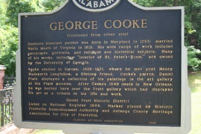
Daniel Pratt Cemetery / George Cooke Marker Side B
| On County Road 57 just north of County Road 6, on the right when traveling north. |
| Near Wetumpka Street at South Washington Street, on the right when traveling east. |
| On Wetumpka Street (County Route 2) at South Washington Street, on the right when traveling east on Wetumpka Street. |
| On Courthouse Square (U.S. 31) at Hand Avenue, on the left when traveling west on Courthouse Square. |
| On Franklin Street north of Washington Avenue, on the right when traveling north. |
| On North Hickory Street at Municipal Park Drive, on the right when traveling south on North Hickory Street. |
| On Alabama Route 59, on the right. |
| On Alabama Route 225, on the left when traveling north. |
| On County Road 32, 0.2 miles west of Sherman Road, on the right when traveling west. |
| On Boatyard Road (County Road 80) 0.2 miles west of Fort Mims Road, on the left when traveling west. |
| On Alabama Route 131 at Dennis Road, on the left when traveling west on State Route 131. |
| On Alabama Route 10, on the right when traveling west. |
| On Hunt Street, 0.1 miles south of Brundidge Street (Alabama Route 10), on the left when traveling south. |
| On West Broad Street east of Colby Avenue, on the right when traveling east. |
| On West Barbour Street, on the left when traveling west. |
| Near North Randolph Avenue at East Browder Street. |
| On School Street east of Engram Street, on the right when traveling east. |
| On Montevallo Road (State Highway 25) at County Road 62, on the left when traveling west on Montevallo Road. |
| On Sixmile School Road south of Montevallo Road (State Highway 25), on the right when traveling south. |
| On Montevallo Road (State Highway 25) at Six Mile School Road, on the left when traveling west on Montevallo Road. |
| On County Route 27 at Fred Young Road, on the right when traveling south on County Route 27. |
| On County Road 36, 0.1 miles north of New Home Church Road, on the right when traveling north. |
| On Alabama Route 239, 0.4 miles south of U.S. 29, on the right when traveling south. |
| On Old Troy Road, on the left when traveling west. |
| On State Highway 223 at County Road 22, on the left when traveling south on State Highway 223. |
| On East Commerce Street (Alabama Route 10) at South Park Street, on the left when traveling west on East Commerce Street. |
| On Airport Road, 0.1 miles south of Old Stage Road, on the right when traveling south. |
| On Martin Luther King Drive east of Douglas Street, on the right when traveling east. |
| On Pelham Road (Alabama Route 21) at 5th Street NE, on the right when traveling north on Pelham Road. |
| On University Circle west of North Pelham Road (State Highway 21), on the right. |
| On Mountain Street Northwest west of Woodward Avenue Northwest, on the left. |
| On University Circle west of North Pelham Road (State Highway 21), on the right. |
| On U.S. 431 at County Route 222, on the left when traveling south on U.S. 431. |
| Near County Road 267, 0.8 miles north of County Road 216, on the left when traveling north. |
| On 1st Street SE at 7th Street SE, on the left when traveling south on 1st Street SE. |
| On U.S. 431 near County Road 23, on the right when traveling north. |
| On Boulevard at Combs Street, on the right when traveling south on Boulevard. |
| On Cherry Drive at North 13th Avenue, on the right when traveling west on Cherry Drive. |
| On State Highway 273 at County Road 81, on the left when traveling north on State Highway 273. |
| On Canyon Drive (Alabama Route 35) at Main Street (Alabama Route 68), on the right when traveling south on Canyon Drive. |
| On County Road 29 at County Road 8, on the right when traveling north on County Road 29. |
| On County Road 425, on the left when traveling south. |
| On County Road 63, 0.7 miles north of State Route 143, on the left when traveling north. |
| On Indian Way (County Road 5) at State Route 17, on the right when traveling east on Indian Way. |
| On Main Street Circle west of Main Street South, on the right when traveling west. |
| On Mount Zion Road, 1.8 miles north of U.S. 84, on the right when traveling north. |
| On Commerce Street (Alabama Route 177) at Magnolia Drive, on the right when traveling west on Commerce Street. |
| On College Avenue (Alabama Route 177) at West Clinton Street, on the right when traveling south on College Avenue. |
| On Davis Avenue East east of East Front Street. |
| On West Bend Road (County Route 31) north of Jamestown Lane, on the right when traveling north. |
| On U.S. 84 at County Road 22, on the right when traveling west on U.S. 84. |
| On Alabama Route 9 at Main Street, on the left when traveling north on State Route 9. |
| On Alabama Route 51, on the left when traveling south. |
| On Alabama Route 141, on the left when traveling south. |
| On South Carroll Street south of Petty Circle, on the left when traveling south. |
| On County Route 248, 1.2 miles north of Alabama Route 12, on the left when traveling north. |
| On Middle School Road north of Old Lee Highway (County Road 20), on the left when traveling north. |
| On LaGrange College Road south of Alabama Route 157, on the right when traveling north. |
| Near LaGrange College Road, 0.9 miles west of Alabama Route 157. |
| On Main Street at 1st Street, on the left when traveling south on Main Street. |
| On Lagrange College Road. |
| On S. Wilson Dam Highway, 1 mile Kimberley Drive. |
| On Sterling Boulevard near Southeast 11th Avenue, on the left when traveling east. |
| On Wilson Dam Avenue at Pickwick Street on Wilson Dam Avenue. |
| Near Keller Lane at North Commons Street West, on the left when traveling north. |
| On North Main Street at East 1st Street, on the right when traveling north on North Main Street. |
| On Trenholm Memorial Drive east of South High Street, on the right when traveling east. |
| On Conecuh County 30, 0.2 miles east of Conecuh County 5, on the right when traveling east. |
| On County Road 15, 1 mile south of County Road 5, on the right when traveling south. |
| On West Front Street (U.S. 84) 0.1 miles east of Cooper Street (State Route 83). |
| On South Main Street (County Road 42) at Cemetery Avenue, on the left when traveling south on South Main Street. |
| On East 3 Notch Street at 6th Avenue, on the right when traveling west on East 3 Notch Street. |
| On Mohegan Street at Seminole Street, on the right when traveling south on Mohegan Street. |
| Near County Road 67 at U.S. 84, on the right when traveling west. |
| On Montgomery Highway (U.S. 331) south of New Bethel Church Road, on the left when traveling south. |
| On 3rd Street at Pitts Road, on the left when traveling west on 3rd Street. |
| On Wesley Avenue (County Road 1669) 0.2 miles north of U.S. 278, on the right when traveling north. |
| On Oates Drive east of College Street (Alabama Route 123/134), on the right when traveling east. |
| On Andrews Avenue (Alabama Route 249) west of Meadowlake Drive, on the right when traveling west. |
| On Andrews Avenue, on the right when traveling south. |
| On Randolph Street, 0.3 miles north of West Hwy 134 East (Alabama Route 134), on the right when traveling north. |
| On Alabama Route 22, on the left when traveling east. |
| On Summerfield Road at 1st Avenue, on the right when traveling south on Summerfield Road. |
| On Washington Street at Alabama Avenue, on the right when traveling north on Washington Street. |
| On Broad Street (Business U.S. 80) at Minter Avenue, on the right when traveling south on Broad Street. |
| On Gault Avenue North (U.S. 11) east of 4th Street, on the right when traveling east. |
| On Gault Avenue North (U.S. 11) east of 4th Street, on the right when traveling east. |
| On Alabama Route 75, 0.1 miles east of Main Street (Alabama Route 227), on the right when traveling north. |
| On Railroad Avenue at Mountain Street, on the right when traveling west on Railroad Avenue. |
| On Holtville Road (Alabama Route 111). |
| On Lancaster Street, 0.1 miles north of Holtville Road (Alabama Route 111), on the right when traveling north. |
| On Micanopy Street, 0.1 miles west of NW Main Street, on the right when traveling west. |
| On Martin Luther King Avenue north of McGlasker Street, on the right when traveling north. |
| On Shoffner Street (County Road 22) at Snowden Street, on the right when traveling west on Shoffner Street. |
| On Chestnut Street at South 11th Street, on the right when traveling east on Chestnut Street. |
| On Church Street north of Mission Street, on the right when traveling south. |
15324 entries matched your criteria. The first 100 are listed above.
Next 100 ⊳