609 entries match your criteria. The first 100 are listed. ⊳
Asian Americans Topic
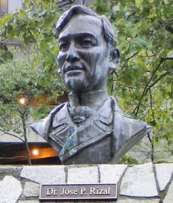
By Richard E. Miller, September 16, 2013
Bust of Dr. José P. Rizal, the martyred father of Philippine independence, in Juneau's Manila Square
| 1 ► Alaska, Juneau Borough, Juneau, Downtown Juneau — Manila Square — |
| On Marine Way (Alaska Route 7) at South Franklin Street (Alaska Route 7), on the left when traveling west on Marine Way. | |||
| 2 ► Alaska, Ketchikan Gateway Borough, Ketchikan — Diaz Café — Circa 1921 — In the heart of Ketchikan's Filipino community — |
| On Stedman Street north of Thomas Street, on the right when traveling north. | |||
| 3 ► Alaska, Ketchikan Gateway Borough, Ketchikan — New York Hotel & Café — Circa 1924 — A family twice removed — |
| On Stedman Street south of Creek Street, on the right when traveling north. | |||
| 4 ► Alaska, Ketchikan Gateway Borough, Ketchikan — Ohashi's — 1907 — A little of everything … for over 100 years — |
| On Stedman Street south of Creek Street, on the left when traveling south. | |||
| 5 ► Alaska, Ketchikan Gateway Borough, Ketchikan — Stedman-Thomas Historic District — The other downtown — |
| On Stedman Street south of Creek Street, on the left when traveling south. | |||
| 6 ► Alaska, Ketchikan Gateway Borough, Ketchikan — Tatsuda's Grocery — Circa 1916 — Ketchikan's longest running family business, almost a century old. — |
| On Stedman Street at Thomas Street, on the right when traveling north on Stedman Street. | |||
| 7 ► Alaska, Ketchikan Gateway Borough, Ketchikan — The Lost Frontier — World War II uprooted Japanese-Alaskans — |
| On Stedman Street south of Creek Street, on the left when traveling south. | |||
| 8 ► Arizona, Cochise County, Tombstone — 41 — Hoptown — Chinese Section — 1879 — |
| On South 3rd Street south of East Allen Street, on the right when traveling south. | |||
| 9 ► Arizona, La Paz County, Parker — Poston Memorial Monument — |
| On Mohave Road, 11.7 miles south of Arizona Route 95, on the right when traveling north. | |||
| 10 ► Arkansas, Desha County, Rohwer — A Look Back In Time — |
| Near State Highway 1, 0.5 miles north of Rohwer Road, on the left when traveling north. | |||
| 11 ► Arkansas, Desha County, Rohwer — I Am An American — |
| Near State Highway 1, 0.5 miles north of Rohwer Road, on the left when traveling north. | |||
| 12 ► Arkansas, Desha County, Rohwer — Making A Living — |
| Near State Highway 1, 0.5 miles north of Rohwer Road, on the left when traveling north. | |||
| 13 ► Arkansas, Desha County, Rohwer — Rohwer Internment Camp Veterans Memorial — |
| Near State Highway 1, 0.5 miles north of Rohwer Road, on the left when traveling north. | |||
| 14 ► Arkansas, Desha County, Rohwer — Rohwer Japanese American Relocation Center — |
| Near State Highway 1 north of Rohwer Road, on the left when traveling north. | |||
| 15 ► Arkansas, Desha County, Rohwer — Rohwer Relocation Center Memorial Cemetery — |
| Near State Highway 1, 0.5 miles north of Rohwer Road, on the left when traveling north. | |||
| 16 ► Arkansas, Desha County, Rohwer — Taken Away — |
| Near Arkansas Route 1 north of Rohwer Road, on the left when traveling north. | |||
| 17 ► Arkansas, Desha County, Rohwer — Trying To Make A Home — |
| Near State Highway 1, 0.5 miles north of Rohwer Road, on the left when traveling north. | |||
| 18 ► Arkansas, Desha County, Rohwer — Why Us? Why Here? — |
| Near State Highway 1, 0.5 miles north of Rohwer Road, on the left when traveling north. | |||
| 19 ► Arkansas, Drew County, Jerome — Jerome Relocation Center — 1942 – 1944 — |
| On U.S. 165 near Ellington Farm Road (County Road 210), on the right when traveling north. | |||
| 20 ► California, Alameda County, Alameda — ATK Baseball Field — 1916-1938 — |
| On Clement Street at Walnut Street on Clement Street. | |||
| 21 ► California, Alameda County, Alameda — Tonarigumi — Alameda’s Historic Japantown — |
| On Park Street east of Pacific Avenue, on the right when traveling east. | |||
| 22 ► California, Alameda County, Alameda — Tonarigumi — Alameda’s Historic Japantown — |
| On Pacific Avenue north of Park Street, on the right when traveling north. | |||
| 23 ► California, Alameda County, Alameda — Tonarigumi — Alameda’s Historic Japantown — |
| On Buena Vista Avenue south of Oak Street, on the right when traveling north. | |||
| 24 ► California, Alameda County, Alameda — Tonarigumi — Alameda’s Historic Japantown — |
| On Oak Street at Times Way, on the right when traveling east on Oak Street. | |||
| 25 ► California, Alameda County, Berkeley, Central Berkeley — Berkeley High School Alumni: Bobby Seale, Jean Yonemura Wing, Billy Martin — |
| On Alston Way at Martin Luther King Jr. Way, on the right when traveling west on Alston Way. | |||
| 26 ► California, Alameda County, Berkeley, North Berkeley — Birthplace of the Asian American Movement — Berkeley History — |
| On Hearst Avenue at Milvia Street on Hearst Avenue. | |||
| 27 ► California, Alameda County, Berkeley, South Berkeley — "In Tribute to Chiura Obata" — 1885-1975 (小圃 千浦) — |
| On Telegraph Avenue at Dwight Way, on the right when traveling south on Telegraph Avenue. | |||
| 28 ► California, Alameda County, Hayward — Agriculture Pioneer — Innovation and Prosperity — |
| Near Hampton Road near Boston Road. | |||
| 29 ► California, Alameda County, Hayward — Hisako Uyama Partridge — 1931 - 2013 — |
| Near North 3rd Street near Crescent Avenue. | |||
| 30 ► California, Alameda County, Hayward — Working in the Salt Ponds — |
| Near Eden Landing Road. | |||
| 31 ► California, Alameda County, Livermore — From China to America — |
| Near Woodland Court at Figone Way, on the right when traveling west. | |||
| 32 ► California, Alameda County, Oakland — 442nd Regimental Combat Team Memorial — |
| Near Skyline Boulevard, 0.5 miles north of Joaquin Miller Road. | |||
| 33 ► California, Alameda County, Oakland, Downtown Oakland — A Chinese Junk Boat for Oakland — |
| Near 10th Street east of Harrison Street. | |||
| 34 ► California, Alameda County, Oakland, Downtown Oakland — Asian Resource Center — |
| On 9th Street at Harrison Street, on the left when traveling west on 9th Street. | |||
| 35 ► California, Alameda County, Oakland, Downtown Oakland — Oakland’s Chinatowns — Wa Sung Community Service Club |
| Near 10th Street near Alice Street, on the right when traveling east. Reported damaged. | |||
| 36 ► California, Alameda County, Piedmont — The Japanese Teahouse — Cultural Connection Since 1907 — |
| Near Highland Avenue, on the right. | |||
| 37 ► California, Alameda County, San Leandro — Filtration Basins — Lake Chabot Historical Walk — |
| On Estudillo Avenue. | |||
| 38 ► California, Alameda County, San Leandro — Tunnel No. 1 Control Shaft — Lake Chabot Historical Walk — |
| Near Estudillo Avenue. | |||
| 39 ► California, Alameda County, San Leandro — Yem-Po: Chinese Labor Camp — Lake Chabot Historical Walk — |
| Near Estudillo Avenue. | |||
| 40 ► California, Alameda County, San Leandro, Bay-O-Vista — Lake Chabot Historical Walk — Welcome time travelers! — |
| Near Estudillo Avenue, on the right when traveling east. | |||
| 41 ► California, Alameda County, San Leandro, Bay-O-Vista — Roots From Another Land — Lake Chabot Historical Walk — |
| Near Estudillo Avenue, on the right when traveling east. | |||
| 42 ► California, Alameda County, San Leandro, Chabot Park — Memorial to the Chinese Laborers — Lake Chabot Historical Walk — |
| Near Estudillo Avenue, on the right when traveling east. | |||
| 43 ► California, Amador County, Fiddletown — Chew Kee Store — |
| On Fiddletown Road. | |||
| 44 ► California, Amador County, Ione — Ione's Chinatown — |
| On East Main Street at Eldorado Street, on the right when traveling west on East Main Street. | |||
| 45 ► California, Butte County, Oroville — 770 — Chinese Temple — |
| On Broderick Street, on the right when traveling east. | |||
| 46 ► California, Butte County, Oroville — Oroville Chinese Cemetery — 1850 -1944 — |
| On Feather River Boulevard at Gold Dredge, on the right when traveling south on Feather River Boulevard. | |||
| 47 ► California, Calaveras County, Angels Camp — Chinatown — |
| On Birds Way east of South Main Street (California Highway 49), on the left when traveling east. | |||
| 48 ► California, Colusa County, Colusa — Old Chinatown District--Circa 1890 — |
| On Main Street east of 8th Street, on the right when traveling east. | |||
| 49 ► California, Contra Costa County, El Cerrito — A Community of Flower Growers — |
| On San Pablo Avenue south of Manila Avenue, on the right when traveling north. | |||
| 50 ► California, Contra Costa County, El Cerrito — Blooming Business — |
| On San Pablo Avenue, on the right when traveling north. | |||
| 51 ► California, Contra Costa County, El Cerrito — Contra Costa Florist — |
| On San Pablo Avenue south of Manila Avenue, on the right when traveling north. | |||
| 52 ► California, Contra Costa County, El Cerrito — Forced Removal — |
| On San Pablo Avenue south of Manila, on the right when traveling north. | |||
| 53 ► California, Contra Costa County, El Cerrito — Japanese Nurseries — |
| On San Pablo Avenue at Wall Avenue, on the left when traveling north on San Pablo Avenue. | |||
| 54 ► California, Contra Costa County, El Cerrito — The Japanese in El Cerrito, a Timeline — |
| On San Pablo Avenue south of Manila Avenue, on the right when traveling north. | |||
| 55 ► California, Contra Costa County, Hercules — Hercules Powder Works Chinese Laborers Memorial — |
| Near Willet Street at Sycamore Avenue. | |||
| 56 ► California, Contra Costa County, Martinez — Martinez Train Depot — Dedicated September 22, 2001 — |
| Near Marina Vista Avenue near Castro Street, on the right when traveling west. | |||
| 57 ► California, El Dorado County, Coloma — Chinese Miners of the Mother Lode — |
| Near State Highway 49. | |||
| 58 ► California, El Dorado County, Coloma — Chinese Stores |
| Near State Highway 49. Reported permanently removed. | |||
| 59 ► California, El Dorado County, Coloma — Chinese Stores — |
| On Coloma Road (California Route 49) north of Mt Murphy Road, on the right when traveling south. | |||
| 60 ► California, El Dorado County, Coloma — Coloma’s Largest Brick Store — (Site of) |
| On State Highway 49, on the right when traveling south. Reported permanently removed. | |||
| 61 ► California, El Dorado County, Coloma — Unstoppable News — |
| Near Coloma Road (California Route 49) north of Mt Murphy Road. | |||
| 62 ► California, El Dorado County, Gold Hill — 815 — Wakamatsu Tea and Silk Farm Colony — |
| On Cold Springs Road, on the right when traveling north. | |||
| 63 ► California, El Dorado County, Placerville — "Stone House" — Circa 1865 — |
| On Pacific Street, 0.1 miles east of California Highway 49, on the right when traveling west. | |||
| 64 ► California, Fresno County, Coalinga — Harry S. Watanabe — (1896 – 1987) — |
| On Elm Avenue (California Route 33.198) at Phelps Avenue, on the right when traveling north on Elm Avenue. | |||
| 65 ► California, Fresno County, Fresno — China Alley — 街人唐 — |
| On Kern Street at China Alley, on the right when traveling south on Kern Street. | |||
| 66 ► California, Fresno County, Fresno — 934 — Fresno Assembly Center — |
| Near South Chance Avenue, 0.2 miles Kings Canyon Road, on the left when traveling south. | |||
| 67 ► California, Fresno County, Fresno — Kogetsu-Do — |
| On F Street, 0.1 miles west of Kern Street, on the right when traveling west. | |||
| 68 ► California, Humboldt County, Eureka — Eureka’s Chinese Expulsion of 1885 and 1906 — |
| On F Street at Route 101, on the left when traveling south on F Street. | |||
| 69 ► California, Inyo County, Independence — A Community's Living Room — Manzanar National Historic Site — |
| On Manzanar Reward Road. | |||
| 70 ► California, Inyo County, Independence — Icon of Confinement — Manzanar Guard Tower — |
| On Manzanar Reward Road west of U.S. 395, on the right when traveling south. | |||
| 71 ► California, Inyo County, Independence — Legacy — Manzanar National Historic Site — |
| Near U.S. 395, on the left when traveling north. | |||
| 72 ► California, Inyo County, Independence — Manzanar Baseball Field — Play Ball! — |
| Near U.S. 395 at Manzanar Reward Road, on the left when traveling north. | |||
| 73 ► California, Inyo County, Independence — Sacred Space — Manzanar National Historic Site — |
| Near U.S. 395, on the left when traveling north. | |||
| 74 ► California, Inyo County, Independence — Weaving for the War — Manzanar National Historic Site — |
| Near U.S. 395. | |||
| 75 ► California, Kern County, Bakersfield — Joss House — |
| Near Chester Avenue. | |||
| 76 ► California, Kern County, Tehachapi — The Legend of Avelino Martinez — |
| On East F Street, on the right when traveling east. | |||
| 77 ► California, Los Angeles County, Arcadia — 934 — Santa Anita During World War II — |
| Near Huntington Drive west of Baldwin Avenue, on the left when traveling west. | |||
| 78 ► California, Los Angeles County, Glendale, Downtown — Korean Comfort Women Statue — Peace Monument — |
| Near Colorado Street east of Brand Boulevard. | |||
| 79 ► California, Los Angeles County, Long Beach — Long Beach-Yokkaichi Sister City Association — Building Leaders for a Global Community — Peace through Personal Diplomacy — |
| On Federation Drive. | |||
| 80 ► California, Los Angeles County, Los Angeles, Boyle Heights — 1131 — Japanese Hospital — 101 S. Fickett St — |
| On Fickett Street at 1st Street, on the right when traveling south on Fickett Street. | |||
| 81 ► California, Los Angeles County, Los Angeles, Boyle Heights — 1250 — Otomisan Restaurant — |
| On 1st Street just east of Mathews Street, on the right when traveling east. | |||
| 82 ► California, Los Angeles County, Los Angeles, Chinatown — Bruce Lee Statue — |
| Near Broadway north of College Street, on the left when traveling north. | |||
| 83 ► California, Los Angeles County, Los Angeles, Chinatown — Castelar School — |
| On Yale Street south of College Street, on the left when traveling south. | |||
| 84 ► California, Los Angeles County, Los Angeles, Chinatown — Cathay Bank — |
| On Broadway at Alpine Street, on the right when traveling south on Broadway. | |||
| 85 ► California, Los Angeles County, Los Angeles, Chinatown — 826 — Central Plaza — Chinatown — East Gate — |
| On Broadway north of College Street, on the left when traveling north. | |||
| 86 ► California, Los Angeles County, Los Angeles, Chinatown — Chinatown Heritage and Visitor Center — |
| On Bernard Street west of Broadway, on the right when traveling west. | |||
| 87 ► California, Los Angeles County, Los Angeles, Chinatown — Chinese American Communities in Los Angeles — |
| On Los Angeles Street north of U.S. 101, on the right when traveling south. | |||
| 88 ► California, Los Angeles County, Los Angeles, Chinatown — Chinese Massacre — |
| On Los Angeles Street north of U.S. 101, on the right when traveling south. | |||
| 89 ► California, Los Angeles County, Los Angeles, Chinatown — Far East Plaza — Chinese New Year Celebrations — |
| On Broadway north of Ord Street, on the left when traveling north. | |||
| 90 ► California, Los Angeles County, Los Angeles, Chinatown — Garnier Building — 1890 — |
| On Los Angeles Street north of U.S. 101, on the right when traveling south. | |||
| 91 ► California, Los Angeles County, Los Angeles, Chinatown — Lucky Deli — |
| On Broadway north of Ord Street, on the right when traveling north. | |||
| 92 ► California, Los Angeles County, Los Angeles, Chinatown — Spring Street Chinatown — |
| On Spring Street at Ord Street, on the right when traveling south on Spring Street. | |||
| 93 ► California, Los Angeles County, Los Angeles, Chinatown — Sun Mun Way — |
| Near Broadway north of College Street, on the left when traveling north. | |||
| 94 ► California, Los Angeles County, Los Angeles, Chinatown — Sun Wing Wo & Company — |
| On Los Angeles Street just north of U.S. 101, on the right when traveling south. | |||
| 95 ► California, Los Angeles County, Los Angeles, Chinatown — The Garnier Building — |
| On Los Angeles Street north of U.S. 101, on the right when traveling south. | |||
| 96 ► California, Los Angeles County, Los Angeles, Chinatown — Welcome to Chinatown — Chinatown Gateway Monument — |
| On North Broadway just north of Cesar E. Chavez Avenue, on the right when traveling north. | |||
| 97 ► California, Los Angeles County, Los Angeles, Chinatown — Welcome to Chinatown — Chinatown Gateway Monument — |
| On North Broadway just north of Cesar E. Chavez Avenue, on the left when traveling north. | |||
| 98 ► California, Los Angeles County, Los Angeles, Chinatown — 825 — West Gate — Chinatown — |
| On Hill Street, 0.1 miles north of College Street, on the right when traveling north. | |||
| 99 ► California, Los Angeles County, Los Angeles, Downtown Los Angeles — "Go For Broke" — An American Story — |
| On Central Avenue, 0.1 miles north of 1st Street. | |||
| 100 ► California, Los Angeles County, Los Angeles, Downtown Los Angeles — Home Is Little Tokyo Mural — Mural Description — |
| On Central Avenue just south of 1st Street, on the right when traveling south. | |||
609 entries matched your criteria. The first 100 are listed above. Next 100 ⊳