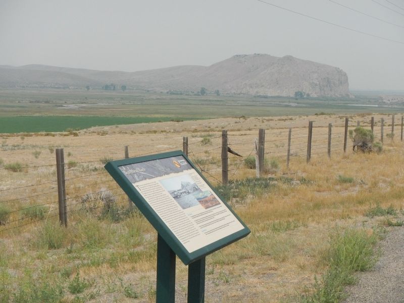
The prominent geological feature to the west is called Beaverhead Rock. On the afternoon of August 8, 1805, members of the Lewis and Clark Expedition pulled its canoes up the Beaverhead River toward the Continental Divide. They sighted what . . . — — Map (db m193249) HM
In midsummer, 1862, John White and party discovered gold on this creek several miles down stream. The first major gold rush to what is now Montana resulted. — — Map (db m124264) HM
About four million years ago, this part of the North American Plate slid over a gigantic source of heat in the mantle known as the Yellowstone hot spot. In Yellowstone National Park, this heat is responsible for the geysers, mud pots, and hot . . . — — Map (db m124335) HM
(Two panels are on this interpretive stand:)
July 8, 1806
The Way It Used To Be... Way Back
Just over two hundred years ago...
We proceeded down Willards Creek on the S.W. Side about 11 miles...The Country . . . — — Map (db m124268) HM
Across the valley is the Continental Divide and the beautiful Bitterroot Mountains. The famous Big Hole River winds through the valley that is noted for abundant hay, fine cattle and horses, great hunting and fishing, beautiful scenery and friendly . . . — — Map (db m124221) HM
Be silent, close you eyes, and listen to the breeze as it rustles through the prairie grasses. To many, the whispering sounds make this a spiritual place. Hunans have defined this lans by its uses and the emotions it stimulates.
First . . . — — Map (db m189806) HM
"See out at sunrise, the current very strong; passed a remarkable bluff of a crimson coloured east on Starboard intermixed with Stratas of black and brick red slate..."
Imagine canoeing against the Missouri's current, never sure of . . . — — Map (db m192881) HM
In 1864, prospectors discovered promising placer gold deposits in Confederate Gulch, named for their political sympathies during the Civil War. This led to a huge gold rush that brought thousands of people to the gulch and the discovery of some of . . . — — Map (db m141735) HM
(Three historical panels are located at this informational kiosk:)(Panel 1:)
Winston - A Town with Dreams of Striking it Rich
Winston History
Welcome to the community of Winston and this area of the . . . — — Map (db m188668) HM
The Pryor Mountains to the east cover roughly 300,000 acres. Once entirely Crow Indian territory, now only the north end of the range is on the Crow Reservation. The south end is in the Custer National Forest. The range is bound on the east by . . . — — Map (db m166982) HM
The Pryor Mountains are located on the horizon to the southeast. The prominent cliffs and dip slopes are Madison Limestone, which was deposited in shallow seas over 300 million years ago. Along the margins of the mountains, younger tan-colored . . . — — Map (db m166979) HM
Medicine Rocks State Park was once a sea of sand dunes. About 61 million years ago during the Tertiary Era, a large freshwater river deposited fine-grained sands along its shores. From there, coastal winds blew the sand into dunes that eventually . . . — — Map (db m164323) HM
If you had visited Medicine Rocks 61.5 million years ago, you would have needed gills to breathe!
A vast river once flowed through the regions, depositing layers of underwater sandbars along its deep channel. Over tine, other rivers buried the . . . — — Map (db m164615) HM
With prairie stretching toward the horizon in nearly every direction, Medicine Rocks seem like a tiny "island" in a vast, grassy sea.
Indeed, the rocky buttes, spires and columns stand tall above the prairie junegrass, little bluestem and . . . — — Map (db m164544) HM
The scenic Highwood Mountains, visible on the skyline to the northeast, are composed of resistant volcanic rocks which tower above the relatively soft surrounding sedimentary rocks. The mountains contain an unusual abundance of a dark igneous rock . . . — — Map (db m143648) HM
During a geologically brief interval of only 3 million years, between 76 and 73 millions years ago. volcanoes erupted blocks of congealed lava and volcanic ash interspersed with lava flows. The volcanoes that erupted this material have since been . . . — — Map (db m245763) HM
On July 16, 1805 as the Expedition was about to enter the Rocky Mountains, Lewis describes some rapids "immediately at the foot of the mountain were the Missouri first enters." He also wrote about a "large pine tree situated on a small island at . . . — — Map (db m245808) HM
Tower Rock marks he (sic) point where the Corps of Discovery left the plains and entered the Rocky Mountains The point where they left the familiar prairies and entered an new terrain.
Only July 16, 1805 Lewis recorded that "at this place . . . — — Map (db m245811) HM
The Lewis and Clark Expedition passed through this canyon of "nearly perpendicular rocks" during its journey up the Missouri River in July 1805. Although the men grumbled about mosquitos and prickly pear cactus, the Corps of Discovery was clearly . . . — — Map (db m245761) HM
While walking the trail, look for the angular red, purple, gray, and green colored rocks. You are looking at geologic signs of transition between soft rock of the prairie and erosion-resistant igneous rock that make up the Adel Mountains. Volcanics. . . . — — Map (db m245815) HM
Lewis and Clark
On their historic Expedition to the Pacific Coast
discovered this
Giant Fountain
June 18 - 1805
In honor of the courage, fidelity and
patriotism of the explorers
this tablet is here
placed and . . . — — Map (db m148969) HM
Discovered by
Capt. Meriwether Lewis
June 13 1805
Power development
The Montana Power Co.
--- 1915 ---
Height of Falls 77.8 Ft.
Height of Dam 65 Ft.
Length of Spillway 1000 Ft.
Maximum Head 155 Ft.
Maximum Capacity . . . — — Map (db m246040) HM
Over 150 million gallons of water flow from Giant Springs everyday and cascade into the Missouri River.
The springs occur where cracks in the rocks above the Madison Limestone allow water to leak upward to the land surface. It is similar to a . . . — — Map (db m127798) HM
...the river appears here to have woarn (sic) a channel in the process of time through a solid rocks." -- Meriwether Lewis, June 13, 1805.
The Early Cretaceous world
The layered sedimentary rocks in the falls and gorge walls . . . — — Map (db m246025) HM
On June, 13, 1805 Captain Meriwether Lewis confirmed the existence of what had been just a legend to many - the Great Falls of the Missouri River. Earlier that day, Lewis, who as suspected the falls were in the area based on what the Minnetaree . . . — — Map (db m141983) HM
From here you can witness one of the shortest rivers in the country flowing into the longest river. The Roe River ranks as one of the shortest rivers at only 201 feet in length. The Missouri River is the longest in the country stretching 2,540 . . . — — Map (db m82765)
Geologists have determined that water seeps into the ground southeast of Great Falls in the Little Belt Mountains, where the Madison Limestone formation is exposed at the land surface. The water then travels through the formation toward Giant . . . — — Map (db m82764)
Bird Tail Rock to the southeast was one of the most prominent landmarks along the Benton Road between Fort Benton and Helena. An igneous intrusion about 55 million years old, it acquired its name because it resembled a "bird's tail" erect and spread . . . — — Map (db m144027) HM
Fifty-five to thirty-four million years ago, volcanoes erupted in several areas of central Montana. The upwelling of magma which fed these volcanoes was largely responsible for the Bears Paw Uplift and for several other isolated mountain ranges in . . . — — Map (db m142530) HM
Like much of Montana, the lands of the Wortman Ranch still look largely as they did even before the days of Lewis and Clark. Except for the irrigated farmland next to the river, the landscapes here haven't changed in character or appearance for . . . — — Map (db m161903) HM
In 1855, geologist Ferdinand V. Hayden explored the upper Missouri River for the United States Geologic Service. At that time, the area was the hunting grounds of the Lakota, Blackfeet, Atsina, and River Crow Indians. A lone white man in Indian . . . — — Map (db m161838) HM
Coal Banks Landing takes its name from the dark layer of lignite coal in the hillsides. The landing was used by steamboats during the Indian War of 1876-77 and the construction of Fort Assinniboine on the northwest side of the Bears Paw . . . — — Map (db m161806) HM
You stand about 500 miles from where the Yellowstone's 670-mile journey begins from its headwater in Yellowstone National Park to the confluence with the Missouri River. The last of America's free flowing rivers, the Yellowstone drains 70,100 square . . . — — Map (db m164403) HM
Striking red rock caps may of the hills of eastern Montana. Some of the rock looks volcanic, so it has incorrect; u been called scoria. Lewis and Clark attributed the red rock to burning coal beds and called the red areas "burnt hills." . . . — — Map (db m163875) HM
The mountains surrounding this valley began to form more than 100 million years ago when tectonic forces compressed the earth's crust and forced layers of underlying sedimentary rock eastward along great thrust faults. The faults stacked flat slices . . . — — Map (db m183612) HM
The Judith Basin occupies a central place in Montana's history. For centuries, the lush grasses of the region attracted large numbers of buffalo, antelope, and deer. The abundant game, in turn, drew Indian hunting parties to this area. But the late . . . — — Map (db m143626) HM
The Lewis and Clark Expedition was sailing when it passed by here!
We set out at a early hour this morning and proceed on principally by the chord untill about 9 A.M. when a fine breeze sprung up for the S.E. and enabled us though . . . — — Map (db m161037) HM
The Missouri River is a meandering oasis; a striking contrast to the harsh environment of the surrounding prairie For centuries, American Indians were drawn to this area to hunt game and gather plants. Ancient camps and bison kill sites are evidence . . . — — Map (db m162052) HM
For the last four miles, you have been floating past a family farm and ranch whose riverfront lands are world-renowned for still looking more as they did when Lewis and Clark journeyed here than virtually any others in America. Much the same can be . . . — — Map (db m246445) HM
A river of ice over 2,000 feet thick moved down this valley. Lake McDonald is evidence of its passing.
When the glacier receded more than ten thousand years ago, it revealed a changed landscape. The ice had quarried away huge amounts of rock. A . . . — — Map (db m82767)
Geologic processes have created a winter wonderland for skiers and snow boarders on Lone Mountain, the prominent peak that rises above Big Sky. Some geologists think that if the mountain was cut in half, there would be a Christmas tree pattern of . . . — — Map (db m192623) HM
The black shale rocks seen in this area represent the muddy sediments deposited by the last ocean to exist in Montana. The shale, known by geologists as the Bearpaw Shale contains fossils of sea-going creatures that lived and died some 70 million . . . — — Map (db m9697) HM
One of the most impressive geologic features in Montana is the mountainside north of you. Notice the prominent layer of white limestone half way up the mountainside. The rocks above this layer were deposited more than 50 miles southwest of here and . . . — — Map (db m161417) HM
Chief Mountain, NINA-STA-QUAY, has alway been known to the Blackfeet people. Identified on maps as King Mountain as early as 1796, this outstanding landmark has long been revered for its supernatural powers. Generations of Blackfeet have used Chief . . . — — Map (db m220323) HM
Only about 26 glaciers remain from the 150 that were here in 1850. That number is dropping steadily. If the weather is clear, you might be able to see what is left of five glaciers in the Many Glacier Valley. As climate changes, both the visible and . . . — — Map (db m45058) HM
The limestone feature (outcrop), located across the road, known as the Madison Limestone Formation, was deposited about 350 million years ago in a shallow sea. It was uplifted about 65 million years ago during the Laramide Orogeny (when the Rocky . . . — — Map (db m80318) HM
This is the former site of the Lewis and Clark Caverns Park Entrance Building, a simple A-frame which welcomed visitors to the park for over fifty years.
In 1939, park management began plans to build a greeting center and caretaker residence . . . — — Map (db m141650) HM
The story of the Elkhorn Mountains Volcanics and the Boulder Batholith is the short of how molten magma or melted rock rising up through the crust of the earth just kept coming and coming and coming - from about 81 to about 74 million years ago. . . . — — Map (db m186551) HM
Rumors of gold in the Little Belt Mountains was enough to cause a stampede by hundreds of miners into the Pig-eye Basin and Yogo Gulch southwest of here in the spring of 1879. Although the placer mines soon played out, there was still enough gold in . . . — — Map (db m143631) HM
The mountains rising to the east lie in the Mission Mountain Wilderness and the Mission Mountain Tribal Wilderness. The range is more than a natural wonder, it is the first place in America where an Indian nation has designated tribal lands as a . . . — — Map (db m159547) HM
The Lewis and Clark Expedition passed through this canyon of "nearly perpendicular rocks" during its journey up the Missouri in July 1805. Although the men grumbled about mosquitoes and prickly pear cactus, the Corp of Discovery was clearly . . . — — Map (db m141859) HM
What makes this place, the Blackfoot River and its surrounding bioregion, so special? The Blackfoot watershed - with its headwaters near here, atop the Continental Divide at Roger's Pass - embraces 1.5 million acres. This vast area offers prime . . . — — Map (db m220015) HM
Here nestled deep in the Big Belt Mountains, is one of the most spectacular canyons in Montana. More than a billion years ago, during the Precambrian Era, and ancient inland seaway deposited these shales and sands, which over time, became these . . . — — Map (db m245714) HM
At an isolated gulch about thirteen miles south of here on August 5, 1949, twelve smokejumpers and a Forest Service employee died when a routine fire unexpectedly turned deadly. The lightning-caused fire at Mann Gulch was spotted by a Forest Ranger . . . — — Map (db m141799) HM
The Sweet Grass Hills posses special significance to the Blackfeet Indians and to other tribes on the northern Great Plains. According to legend, the creator Napi fashioned the hills in the dim past out of rocks left over from the formation of the . . . — — Map (db m161397) HM
Few natural events cause as much fear in people as earthquakes. They remind us that the Earth is always changing and renewing itself and that this sometimes occurs violently and without warning. Earthquakes happen when stored energy is suddenly . . . — — Map (db m141489) HM
The Madison Range rises from the east side of the Madison Valley along an active fault that threads its way along the base of the range. The mountains began to slowly rise along the fault about 50 million years ago and it remains active today. This . . . — — Map (db m192667) HM
August 1805 - The Corps of Discovery struggled upriver toward the Rockies. Illness and injury, along with the increasingly difficult river passage, had eroded the group's morale. But the afternoon of the 8th brought a much needed lift, when . . . — — Map (db m193127) HM
Both before and since the passage of Lewis and Clark, the limestone outcrop in front of you served as an important landmark and meeting area. The Shoshone tribe, from whom Sacagawea had been kidnapped as a child, came to this area every summer. By . . . — — Map (db m193132) HM
Many of the rangelands in this valley still look largely as they did even before the Lewis and Clark Expedition walked here. Yet people and animals have traveled through and use the lands around you since prehistoric times. Montana Highway 41, and . . . — — Map (db m193129) HM
During the last ice age about 15,000 years ago, an enormous glacier pushed down from British Columbia and blocked the Clark Fork River in northern Idaho. The glacier functioned as an ice dam creating the largest glacial lake known to have existed, . . . — — Map (db m123059) HM
Imagine a world very different than we know today. About 1.5 billion years ago during the Precambrian Era, the earth's environment was desolate, with no trees, fish, animals or birds. Shallow seas with extensive near-shore flats were fed by streams . . . — — Map (db m123024) HM
Highway 200 near this rest area passes through one of the most spectacular ice-age landscapes in Montana. Glaciers advanced out to the Mission and Swan ranges, and the mountains in the Bob Marshall-Scapegoat wildernesses, forming an ice cap that . . . — — Map (db m123100) HM
Lewis and Clark’s “CORPS OF DISCOVERY” was the first major expedition launched by the United States to explore new lands with an emphasis on scientific inquiry. Lewis spent months being tutored in both physical and biological sciences in . . . — — Map (db m123129) HM
The parallel lines etched on the side of Mount Jumbo are testimony to a series of dramatic geologic events, the Lake Missoula Floods. Occurring as recently as 15,000 years ago, the floods resulted when the Clark Fork River, which had been dammed by . . . — — Map (db m130301) HM
A Blue Ribbon Flowing Through Paradise
The Yellowstone is the longest free-flowing river in the lower 48 states. For the 103 miles downstream from Gardiner, the river is designated as a "Blue Ribbon" trout stream, the longest single . . . — — Map (db m40554) HM
Northern Yellowstone sustains one of the largest and most diverse populations of free-roaming wildlife seen anywhere on earth.
It is often called "America's Serengeti." About half of the approximately 30,000 elk that summer in the park . . . — — Map (db m40566) HM
In summer, pronghorn might be the only large mammals you see in this valley. In winter the wildlife picture changes dramatically. Herds of elk and bison, mule deer, and bighorn sheep descend from the snowy high country to look for food. Gardner . . . — — Map (db m40579) HM
Elk - Sometimes called "wapiti" (the Shawnee word for "one with a white rump"), elk are often seen in large herds in open areas where they graze on grasses and forbs. Bull elk have antlers that they shed every year. Each spring as the elk age, . . . — — Map (db m40576) HM
What is different about the northern range soils?
While most of Yellowstone is a high volcanic plateau composed of rhyolite, the northern portion of the park is more complex geologically. Here you find landslides, erodible shales and . . . — — Map (db m40572) HM
Captain William Clark and his party rode from the west, following a creek downstream (now called Billman Creek) to the Yellowstone River. Looking to the south, they could see that the Yellowstone River emerged from between the Absaroka Mountains on . . . — — Map (db m231563) HM
(Three panels make up this marker:) Yellowstone River:
Haven for Great Hers of Wildlife
July 24, 1806
"Saw emenc number of Deer Elk and buffalow on the banks. Some beaver...for me to mention or give an . . . — — Map (db m191921) HM
Like much of Montana, the lands of the Mission Ranch still look largely as they did in the days of Lewis and Clark. Ranching, anchored as it is in the land's own natural productivity, is one of the main reasons. The grassland prairies and wooded . . . — — Map (db m193374) HM
The black-capped bluffs located on the east side of the Yellowstone River are called Hepburn's Mesa. The mesa is capped by a basalt lava flow the erupted from a small local volcano vent that has long since eroded away. Geologically, the lava flow is . . . — — Map (db m191798) HM
This stretch of river runs warmer than most mountain streams. A half mile up the trail, underground discharge from Mammoth Hot Springs enters the current and creates a year-round climate for water birds, trout, and aquatic plants. Over the years, . . . — — Map (db m123426) HM
Many Indian people believe that spirits dwell in north central Montana's "island" mountains: the Sweet Grass Hills and the Bear Paw and Little Rocky ranges. Their rugged peaks, clustered like tepees in a camp, offer access to the supernatural and . . . — — Map (db m162053) HM
Many Indian people believe that spirits dwell in north central Montana's "island" mountains: the Sweet Grass Hills and the Bear Paw and Little Rocky ranges. Their rugged peaks, clustered like tepees in a camp, offer access to the supernatural and . . . — — Map (db m162055) HM
The geological history of the front range of the Rocky Mountains is just as jumbled and complicated as the mountains appear from this vantage point. Geological forces far to the west caused this remarkable backdrop. About seventy million years ago, . . . — — Map (db m220209) HM
From this overlook you can see areas of very old rock and nearly relatively young deposits. The Big Belt Mountains on the skyline east of Helena Valley in the far distance are primarily composed of Belt Supergroup rocks deposited about 1.4 billion . . . — — Map (db m188669) HM
During the last ice age about 18,000 years ago, an enormous glacier pushed down from British Columbia and blocked the Clark Fork River in northern Idaho. The glacier functioned as an ice dam creating the largest glacial lake known to have existed, . . . — — Map (db m212233) HM
(This marker is constructed of three attached panels:)
The Blackfoot River Corridor
Welcome to the Blackfoot Recreation corridor. The corridor stretches 26 mile along the Blackfoot River from Johnsrud Park to the Russel Gates . . . — — Map (db m219981) HM
(Two panels make up this marker.)
At 10,157 feet in elevation, magnificent Trapper Peak rises higher than any other peak in the 200 mile-long Bitterroot Mountain Range that extends along the Idaho-Montana border from the Snake River . . . — — Map (db m123595) HM
The spectacular Bitterroot Mountains northwest of Sula expose granite rocks of the Idaho batholith, a major geologic feature that consists of a series of igneous intrusions that pushed their way toward the surface between about 80 and 53 million . . . — — Map (db m123620) HM
This marker is composed of three panels on a common support
The Mystery May Never be Solved
Experts disagree on the exact route Lewis and Clark took over this divide. No one knows where they camped on that cold snowy night . . . — — Map (db m109625) HM
Native peoples occupied the Little Bitterroot River Valley and enjoyed its healing hot springs long before European trappers and traders encroached upon local resources. In 1855, an 80-acre area around the hot springs was set aside as a government . . . — — Map (db m219652) HM
Imagine a rock so old and so deep, that in some places, the bottom has never been found! The mountains you have been driving through are made up of such a rock—the Prichard Formation. Dating back 1.5 billion years, it is one of the oldest . . . — — Map (db m45192) HM
Stop by this wetland on a spring evening to hear the loud ribbitt, ribbitt of hundreds of Pacific tree frogs. They share their haven with a host of amphibians, reptiles, and aquatic insects. What makes this Western Montana wetland . . . — — Map (db m219343) HM
The Boulder Batholith originated as part of the Elkhorn Mountains Volcanics. Molten magma rose up through the earth's crust for 81 to about 74 million years ago. When it reached the surface, the magma created violent explosions that hurled chunks of . . . — — Map (db m186128) HM
This rest area lies near the southwest corner of the Boulder Batholith - a very large collection of igneous plutons. "Igneous" refers to rocks solidified from magma. "Plutons" harden from great blobs of magma that harden deep in the earth. . . . — — Map (db m180834) HM
For over sixty million years during the Cretaceous Period, much of eastern Montana was underwater, covered by an vast inland sea. As the Rocky Mountains formed to the west, it created a broad, flat coastal plain that was home to many different . . . — — Map (db m190925) HM
For over sixty million years during the Cretaceous Period, much of eastern Montana was underwater, covered by an vast inland sea. As the Rocky Mountains formed to the west, it created a broad, flat coastal plain that was home to many different . . . — — Map (db m29123) HM
President Thomas Jefferson's passion for botany fueled his instructions to Meriwether Lewis to notice "the soil and face of the country, it's growth & vegetable productions, especially those not in the U.S. ...the date at which particular . . . — — Map (db m191172) HM
Called Awaxaawippila by the Apsáalooka (Crow) Indians, The Crazy Mountains, which you can see to the northwest, are an igneous formation forged about 50 million years ago. For the Apsáalooka, they are the most sacred and revered mountains on the . . . — — Map (db m191042) HM
Called Awaxaawippiia by the Apsaalooka (Crow) Indians, the Crazy Mountains, which you can see to the northwest, are an igneous formation forged about 50 million years ago. For the Apsaalooka, they are the most sacred and revered mountains on the . . . — — Map (db m28947) HM
The largest hydraulically filled dam in the world, Fort Peck Dan was made from a slurry of sand, silt, clay, and gravel dredged from the Missouri River.
Nearly four miles long, the dam needed over 125 million cubic yards of . . . — — Map (db m162113) HM
For thousands of years, northern Montana was covered under massive ice sheets. Glaciologists aren't sure why the ice ages began, but the process of glaciation is known because of the mark it leaves on the landscape. About 190,000 years ago, . . . — — Map (db m142928) HM
Called Awaxaawippiia by the Apsaalooka (Crow) Indians, the Crazy Mountains, which you can see to the southwest, are an igneous formation forged about 50 million years ago. For the Apsaalooka, they are the most sacred and revered mountains on the . . . — — Map (db m188864) HM
According to geologists, during much of the Cretaceous Period (144 to 65 million years ago), a large portion of Montana was covered by a shallow inland sea called the Western Interior Seaway. The rims towering above Billings are composed of a . . . — — Map (db m167970) HM
River of the "Yellow Stone"
The snowfall in the mountains surrounding Yellowstone National Park feeds the Yellowstone River and its tributaries. Along the Yellowstone River's 678 miles are changes in water temperature, turbidity . . . — — Map (db m167882) HM
101 entries matched your criteria. The first 100 are listed above. The final 1 ⊳