Marker Logo
THE HISTORICAL
MARKER DATABASE
“Bite-Size Bits of Local, National, and Global History”


66 entries match your criteria.  


Historical Markers and War Memorials in Elgin County
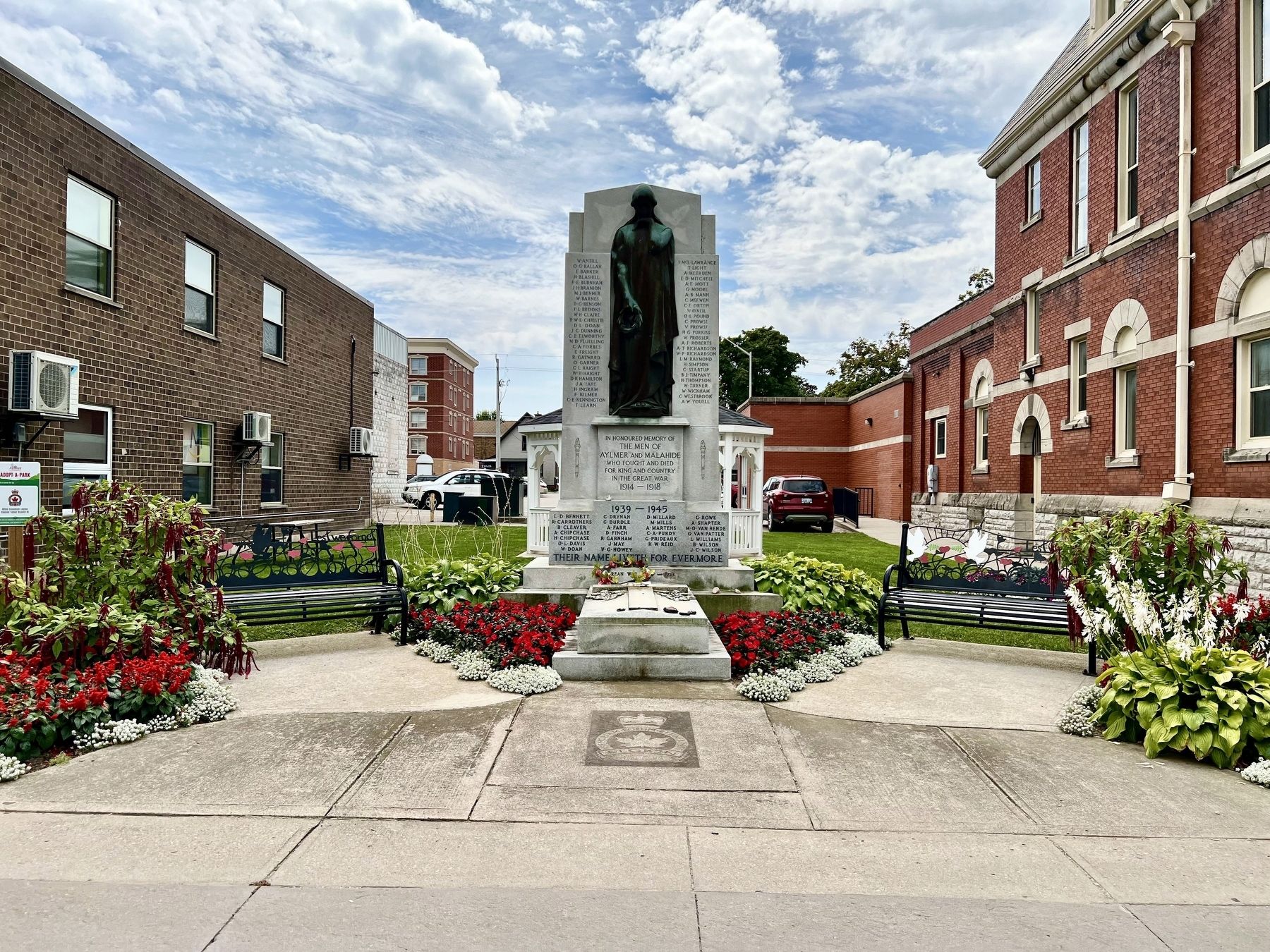
 
By Tim Boyd, August 23, 2024
Aylmer Cenotaph
1 Ontario, Elgin County, Aylmer — Aylmer Cenotaph
In honoured memory of the men of Aylmer and Malahide who fought and died for King and Country in the Great War 1914-1918 (names not transcribed)Map (db m273238) WM
2 Ontario, Elgin County, Aylmer — The Founding of Aylmer
In October, 1817, John Van Patter, an emigrant from New York State, obtained 200 acres of land and became the first settler on the site of Aylmer. During the 1830's a general store was opened and village lots sold. Originally called Tray, in 1835 it . . . Map (db m255222) HM
3 Ontario, Elgin County, Fingal — Burwell’s Corners
Burwell's Corners is named after Mahlon Burwell, the son of United Empire Loyalists, who came to the Talbot Settlement in 1809 at the request of Thomas Talbot, a colonial land administrator. Mahlon Burwell surveyed much of the land from Essex to . . . Map (db m255427) HM
4 Ontario, Elgin County, Fingal — Col. Mahlon BurwellVeteran of the War of 1812
Burwell, a surveyor, was a militia officer during the War of 1812 making him a prime target for enemy raiders who plundered Southwestern Ontario unopposed for most of the last year of the war. He moved to Port Talbot in 1809 with his family to . . . Map (db m255424) HM
5 Ontario, Elgin County, Fingal — Col. Thomas TalbotVeteran of the War of 1812
Col. Thomas Talbot landed immediately south of this location in May of 1803. From here, he would, for the next 30 years, direct the settlement of an immense area stretching from Windsor to Delhi. When he arrived there was nothing but dense bush, . . . Map (db m253447) HM
6 Ontario, Elgin County, Fingal — RCAF No. 4 Bombing and Gunnery School
No. 4 Bombing and Gunnery School was a unit of the British Commonwealth Air Training Plan. The Plan, from April 29, 1940 to March 15, 1945, graduated over 130,000 air crew, of which 73,000 were Canadians. No. 4 B&GS consisted of the main station at . . . Map (db m253435) HM WM
7 Ontario, Elgin County, Fingal — The Talbot Settlement / La Colonie de Talbot
The Talbot Settlement The settlement begun in May 1803 by Thomas Talbot was despite the controversial practices of its founder one of the most successful in Upper Canada. Major roads were constructed throughout the settlement and . . . Map (db m253442) HM
8 Ontario, Elgin County, Iona Station — John Kenneth Galbraith
John Kenneth Galbraith was born here October 15, 1908. Educated at the Ontario Agricultural College and the University of California, Berkeley, he joined the faculty of Harvard University in 1934. During World War II he administered price controls . . . Map (db m253523) HM
Paid Advertisement
9 Ontario, Elgin County, Iona Station — Southwold Earthworks/Les Fortifications en Terre de Southwold
Southwold Earthworks This prehistoric site was once a fortified village occupied by the Neutral Indians between about 1500 and 1650 A.D. An earth and palisade wall, later strengthened by a second wall, protected a cluster of . . . Map (db m255420) HM
10 Ontario, Elgin County, Iona Station — Southwold: The remains of an indian village/Southwold: Les vestiges d’un village amérindien
Southwold: The remains of an indian village Members of the Neutral Amerindian group built a village surrounded by a double palisade here, in Southwold, around the year 1500, it is not known how long the site was occupied, but it . . . Map (db m255419) HM
11 Ontario, Elgin County, Port Bruce — Port Bruce Site of the Royal SaluteAugust 25, 1761
Near here, Sir William Johnson, Superintendent of Indian Affairs for the British colonies, made camp while journeying from New York to negotiate with native tribes in the Detroit area. Upon news from General Amherst of the surrender of Belle . . . Map (db m255238) HM
12 Ontario, Elgin County, Port Burwell — Lieut.-Col. Mahlon Burwell1783 - 1846
Born of Loyalist parents, Burwell became a deputy-surveyor in 1809 and was instructed to lay out the Talbot road for settlement. He was granted 600 acres of land in Southwold Township where he settled in 1815. A close associate of Col. Thomas . . . Map (db m252695) HM
13 Ontario, Elgin County, Port Burwell — Port Burwell Lighthouse 1840
The Port Burwell lighthouse was constructed in 1840. It was part of a national network of light stations equipped with beacon lights to warn or guide ships at sea. The Port Burwell light was used to aid navigation and commercial shipping of local . . . Map (db m198238) HM
14 Ontario, Elgin County, Port Burwell — Trinity Anglican Church 1836
This frame building was begun in 1836 and completed the following year. An example of simple early Gothic Revival architecture, this church was constructed as a result of the interest and substantial financial assistance of Lieutenant-Colonel Mahlon . . . Map (db m252721) HM
15 Ontario, Elgin County, Port Glasgow — Aldborough Pioneers/ Pioneer Parliamentarian
Aldborough Pioneers In the year 1816, Alexander Forbes, Archibald Gillies and Neil Haggart, natives of Scotland, moved from Caledonia, New York and were each granted fifty acres of land by Colonel Talbot in Concessions 12 and 13 of Aldborough . . . Map (db m255531) HM
16 Ontario, Elgin County, Port Glasgow — Aldborough Pioneers’ and Soldiers’ Memorial Park “Historic Stone”
Following the burning of the mill at Port Talbot in 1814 by American forces after the War of 1812 Colonel Talbot donated this stone to Peter McKellar to use in the valley mill he was building on Sixteen Mile Creek in Aldborough west of New . . . Map (db m255521) HM
17 Ontario, Elgin County, Port Glasgow — Burning of the Mills, 1814
With the British loss at the Battle of Lake Erie in September of 1813, supplies could no longer be brought by boat to Forts Detroit and Malden on the Detroit River. With many Native Allies to feed, the British were forced to withdraw along the . . . Map (db m255492) HM
Paid Advertisement
18 Ontario, Elgin County, Port Glasgow — Port Glasgow Summer Dance Pavilion
In 1921 the Aldborough Old Boys Association constructed this summer dance pavilion. The first dance was held Wednesday, August 3, 1921 with the music supplied by a local group: Vernon "Hubby" Morris - violin, Ada (Johnson) Murray - piano, and . . . Map (db m255547) HM
19 Ontario, Elgin County, Port Stanley — Bridges
Originally, Port Stanley residents had to use small boats to cross Kettle Creek. In 1843, the Province of Canada built a swing bridge across the Harbour. This bridge would allow vessels to travel north of the bridge if the creek was deepened . . . Map (db m253079) HM
20 Ontario, Elgin County, Port Stanley — Col. John BostwickVeteran of the War of 1812
Port Stanley was not yet settled when the War of 1812 broke out, however, the land on which it sits had been granted to John Bostwick, a native of Massachusetts, then living in the Long Point region. He had come to Upper Canada with his brother in . . . Map (db m252879) HM
21 Ontario, Elgin County, Port Stanley — Commemoration of Port Stanley Harbour1827 - 1939
This tablet erected in 1939 commemorates more than one hundred years of development of Port Stanley harbour beginning with the launching of schooner “Sterling” in 1827 of 90 tons burthen and commencement of first harbour pier. The steamer “Thames" . . . Map (db m253080) HM
22 Ontario, Elgin County, Port Stanley — Lieut.-Col. John Bostwick1780 - 1849
Born in Massachusetts, Bostwick came as a child to Norfolk County. He was appointed high constable of the London District in 1800 and sheriff in 1805. A deputy surveyor, he laid out some of the earliest roads in the Talbot Settlement and in 1804 was . . . Map (db m284031) HM
23 Ontario, Elgin County, Port Stanley — Port Stanley
Kettle Creek was called by the Iroquois the "Kanagio", by the Ojibwas the "Akiksibi", by the French the "Rivière Tonti". Among early visitors were: Louis Jolliet, September, 1669; Dollier and Galinée, April, 1670; the Celoron expedition, . . . Map (db m252912) HM
24 Ontario, Elgin County, Port Stanley — The London and Port Stanley Railroad / Le Chemin de Fer London and Port Stanley
The London and Port Stanley Railroad After the Great Western Railway reached London in 1853, local businessmen and politicians began promoting a competitive line south to Lake Erie. The London and Port Stanley Railway began . . . Map (db m253034) HM
25 Ontario, Elgin County, Port Stanley — The Telegraph Office and the Traction Line
H   E   L    L    O ....  .   ._.. ._.. _ _ _ In the early years of the last century, if you wanted your cousin in the Northwest Territories to know that his Aunt Millie had taken a turn for the worse you would probably have headed for the . . . Map (db m253428) HM
26 Ontario, Elgin County, Sparta — 10 — Baptist Parsonage1855
A modest example of Greek Revival architecture and suited to the plain tastes of a Quaker-influenced community, this house was built in 1855. It is characterized by a symmetrical facade, and a centre doorway with pilasters and a dentiled cornice. . . . Map (db m260329) HM
Paid Advertisement
27 Ontario, Elgin County, Sparta — Eli Mann Cairn
This cairn was first erected in 1935 on the farm of Eli Mann by the Boy Scouts of St. Thomas. Eli had hosted all of the scout camps and activities on his farm for many years. In 1935, he died as a result of a goring by his bull and the scouts built . . . Map (db m260321) HM
28 Ontario, Elgin County, Sparta — Hiram Burley Smith Early Home and Store
Hiram came to Sparta in 1830 at the age of 19 with $5.00 and a tailor's goose (a 21 lb. iron for ironing woolen garments). He set up as a tailor on this site, building the house in 1842 for himself, his wife Sarah (Mills) and their two sons, Isaac . . . Map (db m260314) HM
29 Ontario, Elgin County, Sparta — 13 — Israel Doan House1845
The Doan family were the first settlers in the Corners (later named Sparta). Jonathan Doan came in 1813 from the Niagara Region and settled just west of the current village. His son Josfa took part in the 1837 Rebellion and fled to the United . . . Map (db m260218) HM
30 Ontario, Elgin County, Sparta — Quilt Block: Drunkard’s Path
In the late 1800s, excessive drinking had become a major concern in the village of Sparta and a Temperance Society was formed with leadership from the Baptist minister, Rev. J.J. Baker, the Methodist minister, Rev. W.H. Graham and Dr. G.A. Shannon. . . . Map (db m260312) HM
31 Ontario, Elgin County, Sparta — Sparta Church Museum and Cultural Centre
This yellow brick building was constructed in 1886, and served as a Methodist Church until 1925 when it became a part of the new United Church of Canada. After substantial fundraising and local participation in its construction, it opened to great . . . Map (db m260359) HM
32 Ontario, Elgin County, Sparta — 15 — The Abbey
Built in the 1840's adjacent to the Mills Hotel (Sparta House), the Abbey was first used as an inn. For a brief time, The True Teller, a Sparta newspaper was published in this building. R.J. Stratton operated a furniture and coffin business . . . Map (db m260357) HM
33 Ontario, Elgin County, Sparta — 21 — The Eakins StoreCirca 1838
Built by Henry Yarwood and sold to John Eakins. The years 1840-1880 marked the prime years of the Sparta Settlement. As the centre of the agricultural community, Sparta had good supplies of water and power supplied by numerous mills on Mill and . . . Map (db m260215) HM
34 Ontario, Elgin County, Sparta — The Founding of Sparta, 1813Elgin County in the War of 1812
As the War of 1812 began Sir Isaac Brock, Upper Canada's military governor, called all men for the militia to assist with the defense of the colony. Because of their historic Peace Testimony, and the understanding established when they came to . . . Map (db m255244) HM
35 Ontario, Elgin County, Sparta — The Sanderson House
This property was originally settled by John Kipp, a Quaker who came up from Pennsylvania after the War of 1812, at the urging of Jonathan Doan. He began this home between 1819 and 1820. Early Quaker Meetings were held here and at Elias Moore's home . . . Map (db m260361) HM
Paid Advertisement
36 Ontario, Elgin County, Sparta — 20 — The Sparta House
David Mills erected this finely built hotel in the American Colonial style: it had double verandas and classical proportions with a large ballroom on the second floor. It features dentils under the eaves, eave returns, a boomtown, pilastered doorway . . . Map (db m260216) HM
37 Ontario, Elgin County, Sparta — The Sparta Settlement
This area of Ontario was originally inhabited by the Attawandarons (Neutrals), but they were dispersed by the conflict between the Hurons and the Iroquois two hundred years before Europeans came to the area. In 1813 Jonathan Doan, a Quaker came . . . Map (db m255291) HM
38 Ontario, Elgin County, Sparta — The Temperance House
This hotel was built in the 1840's by Hitchcock and sold to Isaac Moore who renamed it Elgín House after the governor of the day. Later the Elgin became Ontario House in 1872. This hotel seemed to have the better business than the other hotels in . . . Map (db m260358) HM
39 Ontario, Elgin County, Sparta — 14 — Ye Olde Forge & AnvilCirca 1827
Here is one of the pioneer necessities of any village- the blacksmith's shop, which was built by a Mr. Keller from England. A pit was dug in the clay bank, water added, straw scattered on this and oxen tramped down the mixture which was then built . . . Map (db m260355) HM
40 Ontario, Elgin County, Springfield — Springfield Cenotaph
In memory of the men of Springfield and South Dorchester who fell - and in honour of those who served in the Great War 1914-1918 1939-1945Map (db m273258) WM
41 Ontario, Elgin County, Springfield — The Founding of Springfield
About 1850, some ten years after this area was settled, a school and a Methodist meeting house were erected here on the town line between the Townships of South Dorchester and Malahide. Shortly afterwards a post-office named Clunas was opened, with . . . Map (db m255220) HM
42 Ontario, Elgin County, St. Thomas — Captain. Daniel Rapelje1774-1828
Emigrating from New York State to the Long Point Settlement in 1802, Rapelje later received 200 acres of land on the south side of the Talbot Road at Kettle Creek. He settled here with his family in 1810. A veteran of Lundy's Lane and other battles . . . Map (db m255828) HM
43 Ontario, Elgin County, St. Thomas — Col. the Hon. Thomas Talbot 1771-1853
Founder of the Talbot Settlement, he was born at Castle Malahide, Ireland, a member of the Anglo-Irish nobility. In 1803, after serving in the British Army, and on Simcoe's staff, he was granted 5,000 acres in this region and settled in Dunwich . . . Map (db m255637) HM
44 Ontario, Elgin County, St. Thomas — Dr. Charles Duncombe (1791-1867)
This house was built in 1848 by Dr. Elijah Duncombe brother of Dr. Charles Duncombe. The latter, born in Connecticut, came to Upper Canada in 1819 and settled on this property shortly thereafter. In 1824, with Dr. John Rolph, he opened at St. . . . Map (db m255573) HM
Paid Advertisement
45 Ontario, Elgin County, St. Thomas — Elgin County Courthouse / Palais de Justice Elgin CountyLand Registry Office / Bureau d'enregistrement immobilier
The Elgin Registry Office was built in 1874 during a formative period (1870 to 1886) of constructing separate buildings for the registry offices. A standard design was developed by the Ontario Department of Public Works for registry office . . . Map (db m255730) HM
46 Ontario, Elgin County, St. Thomas — Elgin County Courthouse/ Palais de Justice Elgin CountyGovernor’s Residence/ Résidence du Gouverneur
The former Governor's residence was a two-storey, yellow-brick, Queen Anne-style house. It sat at the south-west corner of the Elgin County Courthouse, facing west towards Stanley Street and the Kettle Creek river valley. The house was . . . Map (db m255655) HM
47 Ontario, Elgin County, St. Thomas — Elgin County Courthouse/ Palais de Justice Elgin CountySite History/ Historique du Site
The Provisional Elgin County Council accepted a site for the courthouse and jail from a local landowner, Benjamin Drake. The site was conveyed to Queen Victoria for county and district buildings in October of 1848. During the planning of . . . Map (db m255656) HM
48 Ontario, Elgin County, St. Thomas — Elgin County Courthouse/ Palais de Justice Elgin County (1853)
The Elgin County Courthouse was built in 1852-53 and is one of the earliest pre-Confederation county courthouses in Ontario. Along with the courthouses of Brant and Norfolk Counties, the Elgin County Courthouse is one of the three . . . Map (db m255667) HM
49 Ontario, Elgin County, St. Thomas — Elgin County Courthouse/ Palais de Justice Elgin County (1898)
After a fire in 1898, St. Thomas architect Neil R. Darrach was commissioned to repair and enlarge the courthouse to meet its growing needs. Darrach's plans closely followed the designs done by the original architect John Turner when he . . . Map (db m255665) HM
50 Ontario, Elgin County, St. Thomas — Elgin County Courthouse/ Palais de Justice Elgin County (2014)
The Elgin County Courthouse has stood as a St. Thomas cultural landmark for more than 150 years. Its restoration and renovation will preserve its historical stature and allow it to continue serving the local and the extended community for . . . Map (db m255657) HM
51 Ontario, Elgin County, St. Thomas — Elgin’s Finest
On Sunday, June 25 1916, a crowd of 20,000 gathered at the Michigan Central Station to see off the 940 men of the Elgin Regiment's 91st Battalion. Travelling by train from St. Thomas to Halifax, they crossed the Atlantic aboard the Olympic and . . . Map (db m255841) HM
52 Ontario, Elgin County, St. Thomas — Hon. Mitchell F. Hepburn 1896-1953
Ontario's eleventh prime minister was born in nearby Yarmouth Township and educated at St. Thomas Collegiate. After serving in World War I, he was elected to the federal parliament in 1926 as member for Elgin West. In 1930 he was named leader of the . . . Map (db m255738) HM
53 Ontario, Elgin County, St. Thomas — Jumbo
On September 15, 1885, the giant African elephant, star of the Barnum and Bailey Circus, met a untimely death when struck in St. Thomas by a Grand Trunk locomotive. To commemorate the one hundredth anniversary of this tragic event, the citizens of . . . Map (db m78342) HM
Paid Advertisement
54 Ontario, Elgin County, St. Thomas — McArthur’s Raid, November 11, 1814Elgin County in the War of 1812
In a fall of 1814 American general Duncan McArthur lead an expedition of 600 mounted riflemen, mostly Kentucky and Ohio volunteers, into Upper Canada from Detroit. He intended to attack Burlington Heights, the closest British encampment, in concert . . . Map (db m255604) HM
55 Ontario, Elgin County, St. Thomas — RCAF Technical Training School / L’École de Formation de L’Aviation Royale du Canada
RCAF Technical Training School The only facility of its kind in Ontario during the Second World War, No. 1 Technical Training School, St. Thomas, was established by the Royal Canadian Air Force in 1939 to produce skilled ground crews for . . . Map (db m255293) HM
56 Ontario, Elgin County, St. Thomas — St. Thomas Canada Southern Railway Station / Gare ferroviaire de St. Thomas
[English] The St. Thomas Canada Southern (CASO) Station, financed by American railway promoters, was constructed between 1871 and 1873 to serve as both the passenger station for St. Thomas and CASO's corporate headquarters. During the 1920s, . . . Map (db m198268) HM
57 Ontario, Elgin County, St. Thomas — St. Thomas Street Railway: 1908
The St. Thomas Street railway opened in 1879. Although it was originally a horse drawn trolley line, the ten mile line was modernized with electrical power in 1898. By 1908, St. Thomas was home to seven different railways. It was then that St. . . . Map (db m255838) HM
58 Ontario, Elgin County, St. Thomas — St. Thomas’ Church 1824
This church was completed in 1824 on land given by Capt. Daniel Rapelje, the founder of the city of St. Thomas. It is one of the province's finest remaining examples of Early English Gothic Revival architecture. In 1825 a tower, steeple and . . . Map (db m255608) HM
59 Ontario, Elgin County, St. Thomas — The Honourable John Rolph, M.D.1793-1870
This property once belonged to John Rolph, a prominent physician, lawyer and legislator. Born in England, he emigrated to Upper Canada in 1812. In 1824, with Dr. Charles Duncombe, he established at St. Thomas the province's first medical school, . . . Map (db m255560) HM
60 Ontario, Elgin County, St. Thomas — The Quaker Settlement at Sparta / La Colonie Quaker de Sparta
Jonathan Doan (1765-1847), a member of the Society of Friends, came to Upper Canada from Pennsylvania about 1789. He settled first in the Niagara peninsula, and then purchased 200 acres of wilderness here in south Yarmouth Township in . . . Map (db m252787) HM
61 Ontario, Elgin County, Vienna — The Edison Homestead
On this site stood the home of Samuel Edison, a Loyalist from New Jersey who had moved to Nova Scotia in 1783 and settled here in 1811. During the War of 1812 he served as a captain in the 1st Middlesex Militia. Tradition maintains that this . . . Map (db m283492) HM
62 Ontario, Elgin County, Wallacetown — Ellis Wellwood Sifton, V.C.1891 - 1917
Born and educated in Walllacetown, Sifton joined the 18th Battalion, Canadian Expeditionary Force, in October, 1914. During the Canadian attack on Vimy Ridge on April 9, 1917, his company was held up by the fire of a German machine gun. . . . Map (db m253504) HM
Paid Advertisement
63 Ontario, Elgin County, Wallacetown — Raids on the Talbot Settlement, 1814Elgin County in the War of 1812
Elgin County's first settlers arrived near this spot in 1809 and by the time the War of 1812 broke out they had only been on the land for a few years. Outside of occasional militia service, the war had little impact on their lives until the fall of . . . Map (db m253508) HM
64 Ontario, Elgin County, Wallacetown — St. Peter’s Church 1827
A fine example of early Gothic Revival-architecture, this Anglican church lies in the midst of the original Talbot Settlement. The nave was erected by the congregation in 1827. The belfry and tower, added in 1845 to accommodate a bell donated by . . . Map (db m253500) HM
65 Ontario, Elgin County, Wallacetown — Tyrconnell
• One of Elgin County's most successful early communities, Tyrconnell was a busy port community during pioneer days. • Mills, greatly needed in the region, were established as early as 1817. Other early additions included a warehouse, post . . . Map (db m255471) HM
66 Ontario, Elgin County, West Lorne — Brock’s Creek
At the beginning of the war of 1812, US General William Hull briefly invaded Southwestern Ontario from Fort Detroit. General Sir Isaac Brock both military commander and civilian governor of Upper Canada at the start of the war, responded by . . . Map (db m255473) HM
 
 
CeraNet Cloud Computing sponsors the Historical Marker Database.
This website earns income from purchases you make after using our links to Amazon.com. We appreciate your support.
Paid Advertisement
Sep. 7, 2026
