600 entries match your criteria. The first 100 are listed. ⊳
California Historical Landmarks Historical Markers
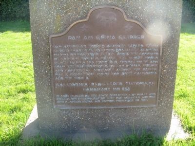
By Syd Whittle, March 14, 2010
Pan Am China Clipper Marker
| 1 ► California, Alameda County, Alameda — 968 — Pan Am China Clipper — |
| On West Mall Square. | |||
| 2 ► California, Alameda County, Berkeley, Southside — 908 — Berkeley City Club — |
| On Durant Avenue near Ellsworth Street, on the right when traveling west. | |||
| 3 ► California, Alameda County, Castro Valley — 776 — Site of First Public School in Castro Valley — |
| On Redwood Road near James Avenue, on the right when traveling north. | |||
| 4 ► California, Alameda County, Fremont, Mission San Jose — 334 — Mission San José — |
| On Mission Boulevard at Washington Boulevard, on the right when traveling north on Mission Boulevard. | |||
| 5 ► California, Alameda County, Fremont, Niles — 46 — Vallejo Flour Mill — ← ½ Mile — |
| On Mission Boulevard (California Route 238) 0.5 miles west of Niles Canyon Road, on the left when traveling west. | |||
| 6 ► California, Alameda County, Fremont, Vineyards - Avalon — 642 — Leland Stanford Winery — |
| On Stanford Avenue near Vineyard Avenue, on the left when traveling east. | |||
| 7 ► California, Alameda County, Livermore — 641 — Concannon Vineyard — |
| Near Tesla Road. | |||
| 8 ► California, Alameda County, Livermore — 586 — Cresta Blanca Winery — |
| Near Arroyo Road. | |||
| 9 ► California, Alameda County, Livermore — 957 — Wente Bros. Winery — |
| Near Tesla Road. | |||
| 10 ► California, Alameda County, Oakland — 970 — Rainbow Trout Species Identified — |
| Near Redwood Road, 0.1 miles north of Redwood Gate, on the left when traveling north. | |||
| 11 ► California, Alameda County, Oakland — 962 — Site of Blossom Rock Navigation Trees — |
| Near Skyline Boulevard, 0.5 miles north of Joaquin Miller Road. | |||
| 12 ► California, Alameda County, Oakland, Downtown Oakland — 896 — First Unitarian Church of Oakland — |
| On Fourteenth Street at Castro Street, on the left on Fourteenth Street. | |||
| 13 ► California, Alameda County, Oakland, Downtown Oakland — 884 — Paramount Theatre — |
| On Broadway at 21st Street, on the left on Broadway. | |||
| 14 ► California, Alameda County, Oakland, Downtown Oakland — 45 — Site of College of California — Original Campus of University of California — |
| On Franklin Street at 14th Street, on the right when traveling north on Franklin Street. | |||
| 15 ► California, Alameda County, San Leandro, Farrelly Pond District — 285 — Peralta House — |
| Near Lafayette Avenue near Leo Avenue, on the right when traveling south. | |||
| 16 ► California, Alameda County, San Leandro, Farrelly Pond District — 246 — Rancho San Antonio — |
| Near East 14th Street (California Route 185) near Toler Avenue, on the right when traveling south. | |||
| 17 ► California, Alameda County, San Leandro, Old San Leandro — 279 — Estudillo Home — |
| On West Estudillo Avenue near San Leandro Boulevard, on the right when traveling west. | |||
| 18 ► California, Alameda County, Union City — 503 — First County Courthouse — |
| On Union City Boulevard near Cambridge Way, on the right when traveling west. | |||
| 19 ► California, Alameda County, Union City — 768 — Site of the Nation’s First Successful Beet Sugar Factory — |
| On Dyer Street at Ratekin Drive, on the right when traveling west on Dyer Street. | |||
| 20 ► California, Alpine County, Kirkwood — 661 — Old Emigrant Road |
| On Carson Pass Scenic Byway (State Highway 88), on the right when traveling east. Reported missing. | |||
| 21 ► California, Amador County, Fiddletown — 35 — Fiddletown — |
| On Fiddletown Road, on the right when traveling east. | |||
| 22 ► California, Amador County, Ione — 788 — Daniel Stewart Co. Store — |
| On East Main Street, on the right when traveling west. | |||
| 23 ► California, Amador County, Ione — 506 — Methodist Episcopal Church — |
| On West Marlette Street at South Sacramento St, on the left when traveling south on West Marlette Street. | |||
| 24 ► California, Amador County, Ione — 867 — Preston Castle — |
| On Highway 104, on the right when traveling east. | |||
| 25 ► California, Amador County, Jackson — 786 — Argonaut and Kennedy Mines — |
| Near State Highway 49. | |||
| 26 ► California, Amador County, Jackson — 865 — Site of Pioneer Jewish Synagogue — |
| On Church Street at North Street, on the right when traveling north on Church Street. | |||
| 27 ► California, Amador County, Plymouth — 762 — D'Agostini Winery — |
| On Plymouth - Shenandoah Road, on the right when traveling north. | |||
| 28 ► California, Amador County, Sutter Creek — 1007 — Knight Foundry — |
| On Eureka Street, on the left when traveling east. | |||
| 29 ► California, Amador County, Volcano — 715 — Astronomical Observatory — |
| On Consolation Street at Main Street, on the right when traveling north on Consolation Street. | |||
| 30 ► California, Amador County, Volcano — 715 — Astronomical Observatory — |
| On Shake Ridge Road, 1 mile west of Rams Horn Grade, on the left when traveling west. | |||
| 31 ► California, Amador County, Volcano — 1001 — Chaw Sé Roundhouse — |
| Near Pine Grove Volcano Road. | |||
| 32 ► California, Amador County, Volcano — 29 — Volcano — |
| On Main Street at Consolation Street, on the right when traveling north on Main Street. | |||
| 33 ► California, Butte County, Chico — 840-2 — Chico Forestry Station and Nursery — |
| Near South Park Drive. | |||
| 34 ► California, Butte County, Chico — 329 — Rancho Del Arroyo Chico — |
| Near Esplanade near Memorial Way. | |||
| 35 ► California, Butte County, Oroville — 770 — Chinese Temple — |
| On Broderick Street, on the right when traveling east. | |||
| 36 ► California, Butte County, Oroville — 1043 — Mother Orange Tree of Butte County — |
| Near Glenn Drive south of Meadowview Drive, on the right when traveling south. | |||
| 37 ► California, Butte County, Oroville — 807 — Oregon City — |
| On Oregon Gulch Road at Oregon City Trail, on the left when traveling south on Oregon Gulch Road. | |||
| 38 ► California, Butte County, Oroville — 809 — The Last Yahi Indian — |
| On Oroville-Quincy Highway at Oak Avenue, on the left when traveling east on Oroville-Quincy Highway. | |||
| 39 ► California, Calaveras County, Altaville — 499 — Altaville Grammar School — |
| Near Main Street (State Highway 49). | |||
| 40 ► California, Calaveras County, Altaville — 735 — Prince-Garibardi Building — |
| On South Main Street (State Highway 49) near Demarest Street, on the right when traveling south. | |||
| 41 ► California, Calaveras County, Angels Camp — 734 — Angels Hotel — |
| On Main Street at Bird Way, on the left when traveling south on Main Street. | |||
| 42 ► California, Calaveras County, Angels Camp — 274 — Carson Hill — |
| On State Highway 49, 3.7 miles south of State Highway 4, on the left when traveling south. | |||
| 43 ► California, Calaveras County, Angels Camp — 276 — Robinson's Ferry — |
| On State Highway 49, on the left when traveling south. | |||
| 44 ► California, Calaveras County, Burson — 254 — Camanche — |
| Near Camanche Parkway South. | |||
| 45 ► California, Calaveras County, Calaveritas — 255 — Calaveritas — |
| On Calaveritas Road at Costa Road, on the right when traveling east on Calaveritas Road. | |||
| 46 ► California, Calaveras County, Campo Seco — 257 — Campo Seco — |
| On Campo Seco Road, on the left when traveling east. | |||
| 47 ► California, Calaveras County, Copperopolis — 296 — Copperopolis — State Registered Landmark No.296 — |
| On Main Street, on the left when traveling south. | |||
| 48 ► California, Calaveras County, Mokelumne Hill — 663 — Calaveras County Courthouse and Leger Hotel — |
| On Main Street at Lafayette Street, on the right when traveling north on Main Street. | |||
| 49 ► California, Calaveras County, Mokelumne Hill — 265 — Chili Gulch — |
| On State Highway 49, on the right when traveling north. | |||
| 50 ► California, Calaveras County, Murphys — 267 — Murphys Hotel — |
| On Main Street at Algiers Street on Main Street. | |||
| 51 ► California, Calaveras County, Murphys — 466 — Peter L. Traver Building — |
| On Main Street. | |||
| 52 ► California, Calaveras County, Murphys — 465 — Site of Brownsville — |
| On Pennsyvania Gulch Road, on the right when traveling south. | |||
| 53 ► California, Calaveras County, San Andreas — 264 — Double Springs — ← 2 Miles — |
| On State Highway 12,, 1.3 miles east of State Route 26, on the left when traveling east. | |||
| 54 ► California, Calaveras County, San Andreas — 258 — Fourth Crossing — |
| On State Highway 49, on the right when traveling south. | |||
| 55 ► California, Calaveras County, Valley Springs — 264 — Double Springs — ← 1 Mile — |
| On State Highway 12/26 west of Double Springs Road, on the right when traveling east. | |||
| 56 ► California, Calaveras County, Valley Springs — 295 — Paloma (Fosteria) — |
| On Paloma Road at Edster Street, on the right when traveling south on Paloma Road. | |||
| 57 ► California, Calaveras County, West Point — 268 — West Point — |
| On State Highway 26 (State Highway 26) at Main Street, on the left when traveling east on State Highway 26. | |||
| 58 ► California, Colusa County, Colusa — 890 — Colusa County Courthouse — |
| Near Market Street. | |||
| 59 ► California, Contra Costa County, Antioch — 932 — Mount Diablo Coal Field — |
| On Somersville Road, in the median. | |||
| 60 ► California, Contra Costa County, Crockett — 731 — The Old Homestead — |
| 61 ► California, Contra Costa County, Diablo — 905 — Mount Diablo — |
| On Summit Road, on the right when traveling north. | |||
| 62 ► California, Contra Costa County, Martinez — 312 — John Muir Home — |
| Near Alhambra Avenue, on the right when traveling south. | |||
| 63 ► California, Contra Costa County, Martinez — 511 — Vicente Martinez Adobe — |
| Near Alhambra Avenue, on the right when traveling south. | |||
| 64 ► California, Contra Costa County, Richmond — 1002-1 — Site of Giant Powder Company — |
| Near Giant (Highway) Road near Atlas Road, on the right when traveling south. | |||
| 65 ► California, Del Norte County, Crescent City — 951 — Battery Point Lighthouse — |
| Near Lighthouse Way. | |||
| 66 ► California, Del Norte County, Crescent City — 541 — Brother Jonathan Cemetery — |
| On South Pebble Beach Drive, on the right when traveling north. | |||
| 67 ► California, El Dorado County, Coloma — 748 — The Coloma Road — |
| Near State Highway 49. | |||
| 68 ► California, El Dorado County, Diamond Springs — 487 — Diamond Springs — |
| On Pleasant Valley Road (State Highway 49), on the right when traveling west. | |||
| 69 ► California, El Dorado County, El Dorado — 486 — El Dorado — |
| On Main Street (Pleasant Valley Road) at Church Street, on the right when traveling west on Main Street (Pleasant Valley Road). | |||
| 70 ► California, El Dorado County, El Dorado — 700 — El Dorado (Mud Springs) — |
| On Pleasant Valley Road, on the right when traveling east. | |||
| 71 ► California, El Dorado County, El Dorado Hills — 699 — Mormon Tavern — Overland Pony Express Route - California — |
| On PG&E-Clarksville Sub-Station Road, on the right when traveling west. | |||
| 72 ► California, El Dorado County, Georgetown — 484 — Georgetown — |
| On Lower Main Street (aka Wentworth Springs Road), on the right when traveling south. | |||
| 73 ► California, El Dorado County, Georgetown — 521 — Greenwood — |
| On Greenwood Road near Georgetown Road (California Highway 193), on the right when traveling east. | |||
| 74 ► California, El Dorado County, Gold Hill — 815 — Wakamatsu Tea and Silk Farm Colony — |
| On Cold Springs Road, on the right when traveling north. | |||
| 75 ► California, El Dorado County, Kyburz — 705 — Moore’s (Riverton) — |
| On U.S. 50 near Ice House Road, on the right when traveling west. | |||
| 76 ► California, El Dorado County, Kyburz — 706 — Webster’s — (Sugar Loaf House) — |
| On Interstate 50, on the left when traveling east. | |||
| 77 ► California, El Dorado County, Meyers — 708 — Yank’s Station — |
| On US Highway 50 (U.S. 50) west of Pioneer Trail, on the left when traveling west. | |||
| 78 ► California, El Dorado County, Pilot Hill — 551 — California’s First Grange Hall — |
| On State Highway 49, on the left when traveling north. | |||
| 79 ► California, El Dorado County, Placerville — 475 — Placerville — Originally Known as “Hangtown” — Incorporated May 13, 1854 — |
| On Main Street at Bradford Street, on the right when traveling west on Main Street. | |||
| 80 ► California, El Dorado County, Placerville — 701 — Placerville Pony Express — Station and Terminus — |
| On Main Street at Sacramento Street, on the right when traveling east on Main Street. | |||
| 81 ► California, El Dorado County, Pollock Pines — 704 — Sportsman’s Hall — |
| On Pony Express Trail east of Exit 57 (U.S. 50), on the right when traveling east. | |||
| 82 ► California, El Dorado County, Rescue — 747 — The Coloma Road — |
| On Green Valley Road at Deer Valley Road, on the right when traveling east on Green Valley Road. | |||
| 83 ► California, El Dorado County, Shingle Springs — 456 — Camp Site of Boston-Newton Party — |
| 84 ► California, El Dorado County, Skinners — 703 — Pleasant Grove House — |
| On Green Valley Road, on the left when traveling east. | |||
| 85 ► California, El Dorado County, South Lake Tahoe — 1048 — Site of Echo Summit — |
| Near U.S. 50. | |||
| 86 ► California, El Dorado County, Strawberry — 707 — Strawberry Valley House — |
| On Highway 50 (U.S. 50) west of Strawberry Lane, on the right when traveling west. | |||
| 87 ► California, Fresno County, Coalinga — 344 — Arroyo de Cantua — 14 Miles — |
| On California Route 33, 0.1 miles south of Dorris Road (California Route 198), on the left when traveling south. | |||
| 88 ► California, Fresno County, Coalinga — 344 — Arroyo de Cantua — 14 Miles — |
| On Dorris Avenue (State Highway 198) 0.1 miles east of State Highway 33, on the left when traveling east. | |||
| 89 ► California, Fresno County, Fresno — 916 — Forestiere Underground Gardens — |
| On Shaw Avenue near Forestiere Avenue, on the right when traveling east. | |||
| 90 ► California, Fresno County, Fresno — 934 — Fresno Assembly Center — |
| Near South Chance Avenue, 0.2 miles Kings Canyon Road, on the left when traveling south. | |||
| 91 ► California, Humboldt County, Eureka — 154 — Fort Humboldt — |
| On Fort Avenue, on the right. | |||
| 92 ► California, Humboldt County, Eureka — 882 — Humboldt Harbor Historical District — |
| Near Highway 101 at S Broadway Street, on the right when traveling north. | |||
| 93 ► California, Humboldt County, Ferndale — 883 — Ferndale — |
| On Highway 211 at Herbert Street, on the left when traveling south on Highway 211. | |||
| 94 ► California, Humboldt County, Petrolia — 543 — California's First Drilled Oil Wells — |
| On Front Street east of Sherman Avenue, on the right when traveling west. | |||
| 95 ► California, Humboldt County, Trinidad — 216 — Town of Trinidad — |
| On Edwards Street at Hector Street, on the left when traveling north on Edwards Street. | |||
| 96 ► California, Humboldt County, Trinidad — 838 — Tsurai — |
| On Edwards Street at Ocean Avenue, on the right when traveling north on Edwards Street. | |||
| 97 ► California, Imperial County, Calexico — 808 — Camp Salvation — |
| On East 5th Street at Heber Avenue, on the right when traveling west on East 5th Street. | |||
| 98 ► California, Imperial County, El Centro — 1008 — Yuha Well — |
| On Interstate 8 at milepost 108, on the right when traveling east. | |||
| 99 ► California, Imperial County, Felicity — 985 — Site of Camp Pilot Knob — |
| On Sidewinder Road North at Tucker Road, on the right when traveling south on Sidewinder Road North. | |||
| 100 ► California, Imperial County, Holtville — 1034 — Site of Rancho El Tecolote — |
| On Country Club Drive, 0.3 miles south of California Route 115 when traveling south. | |||
600 entries matched your criteria. The first 100 are listed above. Next 100 ⊳