1755 entries match your criteria. Entries 301 through 400 are listed.⊲ Previous 100 — Next 100 ⊳
E Clampus Vitus Historical Markers
The Ancient and Honorable Order of E Clampus Vitus (ECV) is a fraternal organization dedicated to the preservation of the heritage of the American West, especially the history of the Mother Lode and gold mining regions of the area. More than 1,400 markers point the way to the past.
On Sidewinder Road North at Tucker Road, on the right when traveling south on Sidewinder Road North.
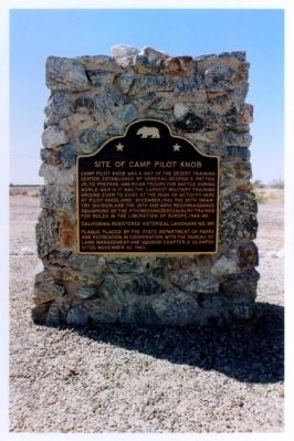
Camp Pilot Knob was a unit of the Desert Training Center, established by General George S. Patton Jr., to prepare American troops for battle during World War II. It was the largest military training ground ever to exist. At the peak of activity here . . . — — Map (db m50590) HM
On West 5th Street at Pine Avenue, on the right when traveling west on West 5th Street.
E Clampus Vitus marker dedicated 1983
Holtville
W. F. Holt established this townsite in 1903; built the first electric power plant at 3rd and Holt, the Holton Interurban RR; started the first church, the first newspaper and donated . . . — — Map (db m62031) HM
On Vanderlinden Road at Interstate 8, on the right when traveling south on Vanderlinden Road.
The church was organized January 14, 1911. The building was constructed the same year on one-half acre of land given by W.J. Seat, located one-quarter mile south of this site. The founders saw Imperial Valley as a land of opportunity for their . . . — — Map (db m153393) HM
On East Worthington Road (County Highway S28) at Bypass Federal Highway 116, on the right when traveling east on East Worthington Road.
From their arrival in Fall, 1901, Swiss and their "Americans of Swiss Descent" have contributed greatly to the ethnic diversity of this valley. Their Schwingfests since 1921 and this club since 1924 have celebrated both their ancestral traditions . . . — — Map (db m108846) HM
On Country Club Drive, 0.3 miles south of California Route 115 when traveling south.
Prolific author Harold Bell Wright purchased 160 acres here in 1907. While living in a tent he built Rancho El Tecolote, constructing a woven arrow weed studio in 1908 and a ranch house in 1909. From 1907 to 1916 he wrote three best sellers, . . . — — Map (db m62032) HM
On West Worthington Road (County Highway S28), on the right when traveling east. Reported missing.
In 1774, Spain opened an overland route from Sonora to California but it was closed by Yuma Indians in 1781. In 1822, Mexico attempted to reopen this route. Lt. Romualdo Pacheco and soldiers built an adobe fort at this site in 1825-26, the only . . . — — Map (db m50589) HM
Bert Vaughn of Jacumba built the stone tower in 1922-23 to commemorate the pioneers and road and railroad builders who opened the area. In the 1930s W.T. Ratcliffe carved the stone animal figures which lurk in the rocks surrounding the tower, . . . — — Map (db m149171) HM
From 1862-70, Peter Larkin and Joe Stancliff used a stone house about a mile north of here as a store from which ox teams pulled wagons up a 30% grade. The San Diego and Fort Yuma Turnpike Co. used the site as a toll road station until 1876. The . . . — — Map (db m50232) HM
On Main Street at Route 111, on the right when traveling east on Main Street.
Three miles east of Niland are the remains of Camp Dunlap, established 15 October 1942 as a training base of the 12th Marines, the Artillery Regiment of the 3rd Marine Division. The camp was named in honor of Brigadier General Robert H. Dunlap, . . . — — Map (db m172159) HM
On Beal Road near Telephone Road, on the right when traveling north.
This is the culmination of a personal religious intensity few mortals will ever experience. Started as a temporary monument to God's love in 1984 by Leonard Knight, it grew into the worldwide phenomenon you see before you.
Born on November 1, . . . — — Map (db m114541) HM
Near Frontage Road, 0.3 miles west of Imperial Highway.
The Imperial Valley College Desert Museum represents the creative vision of noted archaeologist and anthropologist Jay Crawford von Werlhof (1923-2009)
A prolific author, von Werlhof wrote many scholarly books and articles on the archaeology . . . — — Map (db m82451) HM
On Ben Hulse Highway (California Route 78) at 1st Street, on the right when traveling south on Ben Hulse Highway.
Near this spot, situated on the west bank of the Colorado River, about 45 miles north of Fort Yuma, Camp Gaston was established in 1859 by Captain Henry S. Burton, Company F 3rd Artillery. The camp served as a supply post for the Hoffman Expedition . . . — — Map (db m138177) HM
On Ben Hulse Highway (California Route 78) at 1st Street on Ben Hulse Highway.
When Jim Taylor acquired his ferry in 1922, he had just completed his connecting, hand-made highway on both sides of the Colorado River. His plan to attract the Los Angeles to Phoenix traffic had faded with the continued success of the . . . — — Map (db m138179) HM
On Quechan Drive, on the right when traveling south.
Originally called Camp Calhoun, the site was first used as a U.S. Military Post in 1849. A fire destroyed the original buildings. By 1855 the barracks had been rebuilt. Called Camp Yuma in 1852 it became Fort Yuma after reconstruction. Transferred . . . — — Map (db m149168) HM
On Interstate 186, 0.2 miles south of Interstate 8, on the left when traveling south.
Alarcon's mission was to provide supplies for Francisco Coronado's expedition in search of the fabled Seven Cities of Cibola. The Spaniards led by Hernando De Alarcon ascended the Colorado River by boat from the Gulf of California past this point, . . . — — Map (db m88572) HM
As Avi-Milikit of Quechen legends; Picacho noted Spanish arrival in 1640, lured Sonora miners after 1852, brought steamboats to its mining and milling port until 1910. Her mines were never worked to extinction, but Picacho became a squatter haven. . . . — — Map (db m51576) HM
On Picacho Road, on the right when traveling north.
Opened by placer miners after 1852, the gold mines expanded into hard rock quarrying by 1872. Picacho employed 700 miners at its peak from 1895 to 1900. Mill accidents, low ore quality, and the loss of cheap river transport with the building of . . . — — Map (db m50584) HM
On Grays Well Road, on the right when traveling east.
This unique plank road seven miles long was the only means early motorists had for crossing the treacherous Imperial Sand Dunes. The eight by twelve foot sections were moved with a team of horses whenever the shifting sands covered portions of the . . . — — Map (db m50682) HM
On Quechan Drive, 0.1 miles north of Quechan Road, on the left when traveling north.
In October 1780, Father Francisco Garces and companions began Mission La Purisima Concepcion. The mission/pueblo site was inadequately supported, colinists ignored Indian rights, usurped the best lands and destroyed Indian crops. Completely . . . — — Map (db m46896) HM
On West Mehring Road, 0.1 miles west of Imperial Road, on the right when traveling west.
To protect the Anza Trail where it forded the Colorado River, the Spanish founded a pueblo and mission nearby on January 7, 1781. Threatened with the loss of their land, the Quechans (Yumas) attacked this strategic settlement on July 17, 1781. The . . . — — Map (db m29057) HM
On Gold Rock Ranch Road at Walker Way on Gold Rock Ranch Road.
Pete Walters of Ogilby discovered the first gold vien at Gold Rock on January 6, 1884. From his little Mary claim began a gold camp which reached its peak development between 1893 and 1899 as Hedges, with 3200 residents. Nearly closed, 1900-10, it . . . — — Map (db m50581) HM
On California Route 168 north of Reservoir Road and Cataract Road, on the right when traveling east.
With the discovery of gold and silver in Nevada at Goldfield and Tonopah, the need for electric power for mining operations was fulfilled in September, 1905, by construction of a hydro-electric plant on Bishop Creek, which supplied 1,300 . . . — — Map (db m629) HM
On Three Flags Highway (State Highway 395) at County Route 168, on the right when traveling north on Three Flags Highway.
Camp Independence soldiers needed a road to Waucoba-Deep Springs. In 1873 J. S. "Scott" Broder completed this road and collected tolls until 1900. In 1913 A. L. Westgaard led an American Automobile Assn. tour across here, seeking a new . . . — — Map (db m54425) HM
On California Route 168, 1.9 miles east of U.S. 395, on the right when traveling east.
Zurich Station, formerly Alvord, was established in 1884 as a freight and passenger station on the Carson & Colorado Railway - known locally as "The Slim Princess."
Zurich was the main railroad station for Big Pine and points east. Its name . . . — — Map (db m92763) HM
On North Main Street, on the left when traveling north.
This historic mining artifact is known as a track mucking machine. It dates back to the 1960s and was used by Union Carbide Corporation at the nearby Pine Creek Tungsten mine 20 miles North West of Bishop. During World War II and for some years . . . — — Map (db m78131) HM
On Buttermilk Road near California Route 168, on the right when traveling west.
Behind this plaque is the original road that went to the Bishop Creek Drainage. Built at the turn of the 20th Century, this road brought miners and supplies to the Wilshire Mine, known today as the Cardinal Mine.
Seven miles up this road was . . . — — Map (db m189377) HM
Near this location, on Oct. 1, 1871, escaped convicts Moses Black and Leander Morton were lynched by vigilantes to avenge the killing of Robert Morrison, a well liked Wells Fargo agent from Benton. Morrison was a member of the sheriff's posse who . . . — — Map (db m72571) HM
On Highway 6 (U.S. 6) at Silver Canyon Road, on the right when traveling east on Highway 6.
The first white man’s settlement in northern Owens Valley was built here in 1861 and two years later prospectors named it Owensville. It thrived for some time but in 1864, as mining in the White Mts. petered out the miners moved on to better . . . — — Map (db m2953) HM
On Highway 395, on the right when traveling south.
West of this spot, gold was discovered in the Pine Creek drainage by Civil War veterans. It was not until April, 1916, when tungsten was discovered by four men: O.E. Vaughn, A.E. & C.C. Beauregard, and James Sproul on their claims, Blizzard 1, 2, 3 . . . — — Map (db m2952) HM
On Airport Road, 0.7 miles north of East Line Street.
Fifty years ago, the eastern edge of the Sierra Nevada was the site of intense atmospheric research to explore the cause and dynamics of the newly appreciated and powerful mountain wave phenomenon known locally as the Sierra Wave.
This . . . — — Map (db m156150) HM
On West Line Road (California Route 168) west of Muny Road, on the right when traveling west.
In 1861, Samuel A. Bishop, his wife and party left Fort Tejon for the Owens Valley driving 650 head of stock. On August 22, Bishop reached a creek later named for him and southwest of this spot, established San Francis Ranch. There a peace treaty . . . — — Map (db m627) HM
On Main Street (U.S. 395) at East Pine Street, on the right when traveling north on Main Street.
In August 1924 Matt Wilkenson opened the Kittie Lee Inn, which was named for his daughter. When William R. Whorff purchased it in 1925, the Kittie Lee became "the" place to stay for Hollywood's finest.
When Bishop Airport was a training center . . . — — Map (db m72572) HM
A hybrid offspring of a male donkey, commonly known as a jackass and a female horse. Characterized by long ears, a braying voice and short mane, this patient and sure footed animal has been used as a beast of burden throughout the world.
Its . . . — — Map (db m92729) HM
On South Main Street (U.S. 395) at Lagoon Street, on the right when traveling south on South Main Street.
The early days of Inyo County presented many challenges to the original settlers, particularly for peacekeepers. The first sheriff, W.A. Greenly, served only one year. Many officials served only one or two years before resigning. Territorial and . . . — — Map (db m200934) HM
On U.S. 395 at and an un-named dirt road, on the left when traveling south on U.S. 395.
In June 1873 Colonel Sherman Stevens built a sawmill and flume on Cottonwood Creek high in the Sierra’s directly west of this spot. The flume connected with the Los Angeles Bullion Road. The lumber from the flume was used for timbering in the . . . — — Map (db m52104) HM
On Death Valley Road (State Highway 127) at Ash Meadows Road, on the right when traveling south on Death Valley Road.
This building was originally built by the Pacific Coast Borax Company in 1924. The original name of the facility was Corkill Hall, and was the social center for Death Valley Junction between 1924 to 1948.
Between the years 1948 to 1967, Corkill . . . — — Map (db m78582) HM
On State Highway 127, 0.2 miles south of State Highway 190, on the right when traveling south.
This historic crossroad has been used by Indians, Clampers, Death Valley 49ers, ranchers, farmers, settlers and tourists. The town was originally called Amargosa. In 1907, the name was changed to Death Valley Junction. At this junction, the Tonopah . . . — — Map (db m78583) HM
Near California Route 190 near Greenland Boulevard, on the left when traveling north.
Furnace Creek is a spring fed stream flowing into Death Valley. Native Americans lived here centuries prior to its discovery by lost Forty Niners. In 1881, Aaron Winters found borax nearby, and sold his claims and water rights to William Tell . . . — — Map (db m159457) HM
On Shabbell Lane, 0.3 miles north of U.S. 395, on the right when traveling north.
At the request of settlers, Colonel George Evans led a military expedition to this site on July 4, 1862. Hence its name “Independence”. Indian hostilities ceased and the camp closed. War again broke out in 1865 and the camp was reoccupied as Fort . . . — — Map (db m2954) HM
On West Market Street west of Three Flags Highway (U.S. 395), on the left when traveling west.
Thomas Edwards came to the Owens Valley in 1863, acquired land and founded the township of Independence. He built this house in 1865. It is the oldest house in Inyo County. — — Map (db m52101) HM
On Grant Street at Onion Valley Road on Grant Street.
An oil burning steam locomotive, built by Baldwin in 1911, was purchased by the Southern Pacific R.R. in 1928 to haul passengers and freight along the 300 mile narrow gauge line, known locally as the “Slim Princess”. Jim Butler of Tonopah said, “It . . . — — Map (db m52099) HM
Built originally as a stagecoach depot in 1866, it evolved into a railroad station in 1883 to carry freight and passengers on the Carson & Colorado Railroad line, known locally as the "Slim Princess". It served the Independence community from 1883 . . . — — Map (db m72573) HM
On Fish Hatchery Road, 1 mile west of U.S. 395, on the right when traveling west.
In 1916, the citizens of Independence
purchased a 40 acre tract of land and
donated it to the State of California
for the building of a fish hatchery.
This structure was the result. The
first trout were produced in 1918, and
since that . . . — — Map (db m218383) HM
On Cerro Gordo Road just north of California Route 136, on the right when traveling north.
Cerro Gordo discovered by Mexicans in 1865 was at $17,000,000 Inyo's wealthiest mineral producer. Silver, lead, zinc, water and supplies all went by mule train, tram. The "Bessie Brady" boat across Owens Lake and Remi Nadeau mule teams to build the . . . — — Map (db m72747) HM
On California Route 136 at Dolomite Loop (east end) on State Route 136.
In 1862 this high quality deposit of dolomitic limestone was discovered. Its remorte location delayed development until 1883, when the Carson & Colorado Railroad was constructed. In 1885, Drew Haven Dunn filed a mining claim and the Inyo Marble . . . — — Map (db m72577) HM
On Malone Street just south of Railroad Avenue, on the left when traveling south.
From Mound House, Nevada, narrow gauge rails of the Carson & Colorado Railroad reached this site in 1883. Cerro Gordo and other mines faltered, the rail line fell on hard times, so plans to extend the line to Mojave were abandoned, leaving Keeler as . . . — — Map (db m72574) HM
On California Route 136, 1 mile north of Keeler, on the left when traveling north.
Owens Lake was once over 300 feet deep and part of a large ancient freshwater lake. As the climate changed over centuries, the lake began to dry up leaving behind concentrated minerals and salts. By 1905, diversion of water by farmers in the Owens . . . — — Map (db m72575) HM
Near U.S. 395 at Los Angles Aqueduct Road, on the left when traveling north.
The Alabama Gates and gate house were constructed in 1913 when the Los Angeles Aqueduct was built to dewater the aqueduct when maintenance is necessary. On November 16, 1924, seventy or more local citizens seized the aqueduct at the Alabama Gates . . . — — Map (db m93252) HM
On U.S. 395, 2.7 miles north of California Route 190, on the right when traveling north.
In the 1870’s bullion bars from Cerro Gordo mines were hauled across Owens Lake on the steamer “Bessie Brady” to Cartago Boat Landing. Remi Nadeau’s 14 mule teams hauled the bullion to Los Angeles, returning with freight. — — Map (db m81960) HM
On Sub Station Road at Esha Street, on the right when traveling east on Sub Station Road.
This cemetery was established in 1865 when Mrs McGuire and her son were killed on Jan. 1, 1865, during the last battle of the 1860's Owens Valley Indian Wars. Those buried here were the Town's founders, including C. Begole and A. Johnson, who along . . . — — Map (db m93443) HM
On Whitney Portal Road at Movie Road, on the left when traveling east on Whitney Portal Road.
Since 1920, hundreds of movies and TV episodes, including Gunga Din, How The West Was Won, Khyber Rifles, Bengal Lancers, and High Sierra, along with, The Lone Ranger and Bonanza, with such stars as Tom Mix, Hopalong Cassidy, Roy Rogers, Gary . . . — — Map (db m52103) HM
On Whitney Portal Road, 0.4 miles west of U.S. 395, on the right when traveling west.
Mt. Whitney Pack Trains was established in 1921 by Frank Chrysler
and Ted Cook. In 1946, Norman B. Livermore, Jr. ("Ike") saw the need
for a large pack operation to handle the Sierra Club trips. He
acquired over 130 horses and mules by purchasing . . . — — Map (db m242716) HM
On Main Sreet (U.S. 395) south of Busch Street, on the right when traveling south.
On March 26, 1872 at 2:30AM, one of the largest earthquakes ever recorded destroyed 52 out of the 59 buildings in Lone Pine.
Because of the scarcity of building materials the largely immigrant population of Lone Pine, (estimated 250-300), . . . — — Map (db m52102) HM
On California Route 178, on the right when traveling north.
Located at Metbury Spring on the Tonopah and Tidewater Railroad, Shoshone was founded in 1910 by Ralph Jacobus "DAD" Fairbanks. After the collapse of the mining camp of Greenwater (approximately 20 miles northwest of here), "DAD" Fairbanks came to . . . — — Map (db m78511) HM
On Trona Wildrose Road at Ballarat Road, on the right when traveling north on Trona Wildrose Road.
3 1/2 miles east of this point lies Ballarat. Established in 1897 as a mining camp and supply center for the gold and silver mines located on the western slope of the Panamint Mountains. It was named after a well-known gold producing area in . . . — — Map (db m159351) HM
On Trona Wildrose Road at Ballarat Road, on the right when traveling north on Trona Wildrose Road.
Rich sliver ore was discovered in December 1872 at the head of Surprise Canyon 12 miles northeast of here. The United States Senators for Nevada, John P. Jones and William Morris Stewart, invested in and promoted the camp which drew a peak . . . — — Map (db m159349) HM
On 17th Street at H Street, on the left when traveling west on 17th Street.
This is the original site of the residence of pioneer merchant Alphone Weill, wife Henrietta, and three children, Irma, Blanche, and Lawrence. The house, built in 1882-3, and now standing in Pioneer Village, was constructed by Alexis Godey, former . . . — — Map (db m55120) HM
Near Lerdo Highway, 1 mile west of California Route 65, on the right when traveling west.
This plaque is dedicated to the men and women who have served in the Armed
Forces of the United States of America and to all the first responders of
this great nation.
Their dedication and commitment to the principals and values of our . . . — — Map (db m247132) HM
Near 4310 Old Alfred Harrell Highway, on the right when traveling west.
These days restaurants come and go in the blink of an eye. But every so often a venue dishes up just the right mix of food and ambiance. Ethel's Old Corral is a perfect example of a restaurant getting it right. Great food, entertainment, customer . . . — — Map (db m89308) HM
On Truxton Street, on the right when traveling east.
This was the site of the original county courthouse in Bakersfield (1874). In 1913 it was purchased by the city for use as a city hall and was occupied until the earthquakes of 1952. The present city hall was dedicated in 1954. — — Map (db m116962) HM
In 1875 a one story wooden building was erected here facing G Street in a swampy area. Facilities were primitive. Cost of the structure was $1,400. — — Map (db m83295) HM
Approximately 3,000 men labored on railroad construction up and over the Tehachapi Mountains in the 1870s.
It took over three years for the line to be completed through Kern County. As the railroad slowly progressed through the county, . . . — — Map (db m25606) HM
Near Lake Isabella Boulevard (County Route 155) south of Kilbreth Drive, on the right when traveling south.
In 1855 gold was discovered in the Kern Valley. Miners flocked here from throughout the world to get in on what was believed to be California's second great gold rush. Towns sprung up in the area but many were abandoned within a few years when the . . . — — Map (db m51825) HM
On 20 Mule Team Parkway east of Rudnick Boulevard, on the right when traveling west.
From 1883 to 1889, wagons hauled borax along this road 165 miles from Death Valley to Mohave. The route was laid out by J.W.S. Perry. He and a muleskinner named Ed Stiles designed the wagons to carry the heavy loads to the rail depot.
The wagon . . . — — Map (db m123893) HM
On Randsburg Mojave Road at 20 Mule Team Parkway on Randsburg Mojave Road.
The Randsburg Mojave Road was built by Rice & Shippee of Mojave to speed stage transportation from the Southern Pacific railroad station at Mojave, to the rich gold mines in the Randsburg area; service commenced on November 22, 1898. The stage left . . . — — Map (db m143407) HM
On Aerospace Highway (California Route 14), on the right when traveling south.
Florence Leontine Lowe was born July 29, 1901 in Pasadena. Through an arranged marriage in 1921, she became the wife of a minister, Rankin Barnes. She ended her relationship with him a few years after bearing a son, Billy.
Florence acquired the . . . — — Map (db m51666) HM
Near South Lancaster Boulevard, 0.4 miles west of 120th Street East, on the right when traveling west.
Home of the Air Force Flight Test Center, Edwards
Air Force Base provides the premier aerospace research, development, test and evaluation and support
for the United States and its allies. More aviation
records have been set at Edwards than . . . — — Map (db m207942) HM
El Camino Viejo (The Old Highway) began as an inland trail prior to 1800. It was originally a refugee route running between present day San Pedro in Southern California to the East Oakland area in the north. It was used by Indians, trappers, . . . — — Map (db m116500) HM
This is the site of the first Catholic Church St. Joseph's and Cemetery built in Kern County in August 1866. It was established by Father Francis Dade, the circuit priest headquartered in Visalia. The Catholic Church here in Havilah was moved to . . . — — Map (db m89215) HM
On Caliente-Bodfish Road (County Route 483), on the right when traveling north.
The last stage coach robbery in Kern County occurred near here on August 26, 1896. The Kernville stage to Caliente was held-up by a lone gunman on horseback who got $1,700 in coin and gold bullion from the Wells Fargo strong box. He did not molest . . . — — Map (db m83415) HM
A fifth generation native of Kern River Valley, Bob is best remembered for the 9 history books he wrote. Without him much of what happened in our valley’s past would have been lost. He was a cowboy, cattleman, ranger, family man and historian. But . . . — — Map (db m25238) HM
On State Highway 178, on the left when traveling east.
Located to the northwest of here, Isabella, a ranching and mining town, was named by Steven Barton in 1893, after Queen Isabella of Spain, Patron of Christopher Columbus. A post office was established here in 1896. In 1953 the community was moved a . . . — — Map (db m76872) HM
Near Lebec Road (Interstate 5), on the left when traveling north.
The first and only "Camel Brigade" of the United States Army Commanded by Lt. Edward F. Beale 1857-1864 San Antonio, Texas to Fort Tejon, California — — Map (db m140695) HM
Near Fort Tejon Road near Interstate 5, on the right when traveling south.
In 1856 the U.S. Army started an experiment using camel for supply transport in the southwest. The camels proved ill suited to the American southwest.
In November 1859 a civilian contractor turned over 28 camels to the Army at Fort Tejon. . . . — — Map (db m32821) HM
On California Route 33 at D Street, on the left when traveling north on State Route 33.
The McKittrick Hotel and Penny Bar is the direct successor to the old Headquarters Hotel and Saloon built by Armando Bandattini in 1898. After the business was destroyed by fire in 1903, Bandattini rebuilt it here, in its original location at the . . . — — Map (db m130415) HM
On Jawbone Canyon Road at Aerospace Highway (California Highway 14), on the right when traveling north on Jawbone Canyon Road.
"Josie" was born on June 18, 1875 in Silver City, New Mexico to Harvey and Harriet Whitehall. At 19 years old, she taught school in Pinos Altos, New Mexico. She married Herbert Hall Bishop on March 4, 1896, bearing him seven children. The Bishops . . . — — Map (db m78560) HM
On Isabella Walker Pass Road (State Highway 178) west of Doyle Ranch Road, on the left when traveling west.
William Scodie, born in 1827 in Prussia, originally moved to Keyesville in 1856 and opened an eating establishment. He relocated to this area in 1861 operating a way-station from his house. Stocking his front room with supplies, he sold to locals as . . . — — Map (db m113824) HM
On Isabella Walker Pass Road (State Highway 178 at milepost 79.8), on the right when traveling east.
Discovered by Joseph R. Walker, American trail-blazer who left the San Joaquin Valley through this pass in 1834. This area was traversed by topographer Edward M. Kern, after whom the Kern River was named, while accompanying the Fremont expedition of . . . — — Map (db m159834) HM
Came to territory by
covered wagon in 1865
Settled here in 1876
Owned and operated
Gwynne Gold Mine, store
hotel and stage station
cattle rancher, Indian agent
Postmistress — — Map (db m83310) HM
On Red Rock Randsberg Road at Butte Avenue, on the left when traveling north on Red Rock Randsberg Road.
Gold was discovered on the slope of Rand Mountain in 1895. From this discovery, the town of Randsburg sprang up almost overnight. By 1899, the town had over 3500 residents. Randsburg boasted a 100-stamp mill and conservative estimates are that . . . — — Map (db m78578) HM
On U.S. 395 just north of Red Moutain Road, on the left when traveling north. Reported missing.
One of the richest silver strikes occurred in the community of Red Mountain. The Kelly and Grady claims started a silver boom which brought prosperity to this region in the 1900's. In one 60 day period over $170,000 in silver was mined from a hole . . . — — Map (db m158901) HM
On U.S. 395, 0.2 miles south of Red Mountain Road, on the right when traveling south.
The Owl Hotel, where the action was!
Dedicated to Hattie, Little Eva and the girls of the line.
While the men mined silver, they dug for gold. — — Map (db m152430) HM
A Monument to
Determination and Perserverance
William Henry "Burro" Schmidt
Took thirty eight years to hand dig this
half-mile long tunnel--Completed in 1936
Born in Rhode Island, January 30, 1871
Died in Ridgecrest, Calif., January . . . — — Map (db m114470) HM
In memory of the men,
women and children who
were the pioneers of the
Midway Sunset Oilfields,
never to be forgotten. This
cemetery was established
November 1911 by
William Brooks of the Taft
Undertaking Company on
land supplied by . . . — — Map (db m200454) HM
On North 10th Street south of West Ash Street, on the right when traveling south.
Built of native adobe, The Fort is a replica of Sutter's Fort in Sacramento. Originally it was built to accommodate county, state, and federal offices, as well as be utilized as a town hall. The Fort was dedicated on May 22, 1940. — — Map (db m169407) HM
Near Wood Street, on the right when traveling east.
The Jameson # 17 oil derrick, which was drilled in 1917 and produced until
the 1980’s, was scheduled to be torn down. In 1974 the local American
Association of University Women and several dedicated people convinced
Jameson Oil Company to donate . . . — — Map (db m88603) HM
To quote the authors, Frank F. Latta, Arnold R. Rojas, and Bonnie Ketterl Kane, per Rancho El Tejon’s Mayordomo (Supervisor) of almost sixty years, Don Jose Jesus Lopez (J.J.), about Avelino Martinez; “He was a little dried up gnome of a man, . . . — — Map (db m98873) HM
On Bear Valley Road, 3.8 miles north of Cummings Valley Road, on the left when traveling north.
In 1872, the fifteen families residing in what is now Bear Valley Springs joined together to
build a schoolhouse in order to provide an education and source of community structure for
their children. The original schoolhouse was erected near . . . — — Map (db m209103) HM
On Iris Way at Violette Court, on the right when traveling north on Iris Way.
“I’m coming to see you Tom”, said James Hayes. “Well, come a’ shooting” Godwin replied ---and he did!
Tom Godwin was a farmer, stock raiser, and owner/manager of the Mountain House bar and restaurant, but he was also the Tehachapi town . . . — — Map (db m232409) HM
Near Woodford-Tehachapi Road south of Country Club Drive, on the left when traveling south.
“The reports of my death are greatly exaggerated,” as we were assured by Mark Twain, and so it is with the Nüwa/Kawaiisu people, the hunter/gatherers who inhabited the areas from the Southern Sierra Nevada, through the Tehachapi . . . — — Map (db m139925) HM
On Tehachapi Boulevard, on the right when traveling west.
Tehachapi Pass became the preferred route connecting the Mojave and the San Joaquin Valley after John C. Fremont and Kit Carson passed this way during the 2nd Fremont Expedition in 1844. Situated at the southern edge of the Sierra Nevada, Tehachapi . . . — — Map (db m51786) HM
On Woodford-Tehachapi Road, on the left when traveling east.
On September 30th torrential rains flooded Tehachapi Creek, undermining the tracks under Santa Fe Engine No. 3834 which was waiting out the storm about ½ mile east of Woodford Station. The engine disappeared into the raging water below. It remained . . . — — Map (db m202039) HM
On Caliente-Bodfish Road (County Road 483) at Walker Basin Road, on the left when traveling south on Caliente-Bodfish Road.
This valley, Walker Basin, was originally named "The Park" before being named for Joseph R. Walker, an early day scout.
The founder of Rankin Ranch, Walker Rankin was 22 when he left Pennsylvania in 1854 for the California "Gold Rush." He . . . — — Map (db m71073) HM
On Glennville-Bakersfield/Granite Road, on the right when traveling south.
Built it 1873 by John Elden, this stand of buildings served as store, restaurant, and lodging place on the stage route between Bakersfield and Glennville. In later years it became a stopping place for freighters and sheepmen who were on their trek . . . — — Map (db m25716) HM
On Woody Road, 0.2 miles south of California Highway 155, on the left when traveling south.
Joseph Weringer, Sr., Born 1855 in Vienna, established the “Weringer Brewery and Bowling Alley” in Bakersfield in 1881. In 1889 he moved here and established the original townsite of Woody, named after pioneer rancher Sparrel Woody. . . . — — Map (db m113825) HM
On Woody Road at State Highway 155, on the left when traveling east on Woody Road.
Dr. Sparrell W. Woody, pioneer rancher, settled in this area in 1862. In 1894 quartz gold was discovered on Blue Mountain. Copper was discovered in 1891 by Joseph Weringer who operated both the Greenback Copper Mine and the Weringdale Hotel. The . . . — — Map (db m83341) HM
Considered by some to be the oldest dwelling in Lake County, the Ranch House was built in the 1850’s to 1860’s. It was associated with the earliest settlement of High Valley and beginnings of agriculture in Lake County. It is a one and one half . . . — — Map (db m26738) HM
On Main Street, 0.1 miles east of California Route 29, on the left when traveling east.
Built in 1876 at the height of the quicksilver mining boom, the Lower Lake stone jail was a response to rapid town growth and the urgent need for civil order. Stephen Nicolai, one of the first stone masons in Lower Lake, built the jail from local . . . — — Map (db m8509) HM
On Milford Grade Road at Hamlin Drive, on the right when traveling south on Milford Grade Road.
First settled by Robert J. Scott on May 10, 1856, Milford is one of the oldest settlements in the Honey Lake Valley. In 1861 the first important flour mill in northeastern California was built here. In recognition of this, and of a sawmill, the . . . — — Map (db m87776) HM
1755 entries matched your criteria. Entries 301 through 400 are listed above. ⊲ Previous 100 — Next 100 ⊳