On Vermont Route 30, on the right when traveling south.
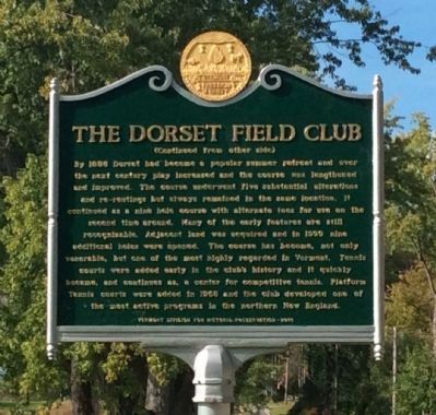
Marker Front: On September 12, 1886 a group of golfers, principally from Troy and New York City, who summered in Dorset, laid out a nine hole golf course, then known as The Dorset Golf Links on this present site. The Club's first president . . . — — Map (db m77585) HM
On Mad Tom Road at Village Street, on the right when traveling north on Mad Tom Road.
Bill Wilson was born November 26, 1895, in a room behind the bar at the Wilson House Hotel. From age 11 until entering the Army, he lived at the Griffith House across the church yard from his birthplace. Bill W. wrote the book "Alcoholics Anonymous" . . . — — Map (db m94430) HM
On Vermont Route 30, on the right when traveling north.
On the site at Hagar Brook stood the small clapboarded mint-house in which Reuben Harmon, Jr. coined copper for the Republic of Vermont, 1785-1788. When the Federal Government was instituted in 1789, Vermont abandoned minting. This rare currency of . . . — — Map (db m73639) HM
On Hildene Road, on the right when traveling north.
Eastward on the hillside can be seen the Manchester estate of Robert Todd Lincoln, eldest son of President Abraham Lincoln and Mary Todd Lincoln. He became fond of Vermont, and for over twenty years made this his summer home. He died here July 25, . . . — — Map (db m95552) HM
On Highland Avenue near Elm Street, on the left when traveling north.
Manchester has three commercial hubs: the Village, the Center, and the Depot, which owes its name and development to the arrival of the Western Vermont Railroad in 1852. Just south of Route 11/30 (originally called the Flat Road and later Depot . . . — — Map (db m176409) HM
On Main Street (Alternate Vermont Route 7) at Union Street, on the right when traveling north on Main Street.
Ethan Allen crossed Lake Champlain to capture Fort Ticonderoga on May 10, 1775 for "America's First Victory." Allen's expedition passed through here on May 5, 1775. Nathan Beman from Manchester guided the expedition into the fort; John Roberts of . . . — — Map (db m78237) HM
On Southern Vermont Art Center Drive, 0.2 miles west of West Road, on the right when traveling west.
Begun in the 1920s as an informal artists' group for the exhibition of painting and sculpture, the Southern Vermont Arts Center has grown to become a leading Vermont institution devoted to performance, exhibition and studio art. It acquired the . . . — — Map (db m78227) HM
On Murphy Road, 0.1 miles south of N Bennington Road (Vermont Route 67A), on the right when traveling north.
A Bridge From An Industrial Past to a Green Future
In New England, the industrial revolution was driven by water power.
With its many rivers, this made Bennington an early leader in manufacturing of many types. Many of these dams now lie . . . — — Map (db m193203) HM
On U.S. 67 close to Harrington Rd, on the right when traveling east.
A few feet east of this marker stood the house, removed about 1870, in which Lieutenant Colonel Friedrich Baum died. Commander of the enemy forces, he was mortally wounded in the battle of Bennington and died two days later, August 18, 1777.
He was . . . — — Map (db m58451) HM
On River Road at Murphy Road, on the left when traveling west on River Road.
A Bridge from Past to Present
You are standing at a hub of Vermont history. The Green Mountain Boys were born here. General John Stark and Colonel Seth Warner marched on to victory at the nearby 1777 Battle of Bennington through here. This . . . — — Map (db m193190) HM
On River Road at Murphy Road, on the left when traveling west on River Road.
A Brief History
The Village of North Bennington established McWaters Park in 2007. The Park is named in honor of Rob and Jean McWaters in recognition of local community involvement. Residents are
creating a perma forest consisting of berry . . . — — Map (db m193197) HM
On Murphy Road, 0.1 miles south of N Bennington Road (Vermont Route 67A), on the left when traveling north.
Paper Mill History The former Vermont Tissue plant is located in Bennington in "Paper Mill Village” on the north side of the island on the Walloomsac River. The plant is a listed Brownfields site. The site is privately owned by AOE, Inc. who . . . — — Map (db m193206) HM
Near Buckley Road (Vermont Route 67) at Depot Street, on the right when traveling north.
The North Bennington Railroad Station was constructed in 1880, replacing an earlier wood frame station located on the same site.
For over half a century, the depot served as the gateway to the village.
Beginning in the 1930’s, with the gradual . . . — — Map (db m116755) HM
On Murphy Road at Riverside Drive, on the right when traveling south on Murphy Road.
Forty feet west of this spot
stood the home of
Seth Warner
Colonel of the Green Mountain Boys,
during his residence in Bennington.
Hero of Hubbardton and Bennington
Battles, 1777.
The house was destroyed by fire
in 1858.
Erected . . . — — Map (db m193183) HM
On Murphy Road near Austin Hill Road, on the right when traveling west.
Near this site
stood the homestead of
Lieut. James Breakenridge
after years of peaceable possession his farm was claimed by New York land speculators - A sheriff and over three hundred men came from Albany to evict him from his home - . . . — — Map (db m77019) HM
On Murphy Road near Ore Bed Road, on the left when traveling north.
This quiet spot was once a major river crossing. Traffic between southwestern Vermont and New York State crossed here, until the railroad was built in 1852, troops marched from Manchester, Vermont to the Battle of Bennington in 1777, and teams and . . . — — Map (db m77062) HM
Editor and publisher the Vermont Gazette
Bennington
Uncompromising in defense of freedom of the press
Imprisoned in 1800 for opposition to Alien and Sedition Laws as threats to the newborn democracy
Erected in 1912
On site of first . . . — — Map (db m77021) HM
On Monument Circle at Monument Avenue on Monument Circle.
was built there was no circular road on this hill top. The original road from Williamstown, Mass. came through Pownal, Vt. to Bennington, and continued straight through the village, over this hill north towards Shaftsbury.
All of the buildings . . . — — Map (db m77051) HM
On Monument Ave. at Main Street (Vermont Route 9), on the left when traveling north on Monument Ave..
On August 16, 1777, British forces sent by Gen'l Burgoyne to seize supplies at Bennington were turned back by New Englanders under Gen'l John Stark and Vermont's Col. Seth Warner. This 306 foot commemorative shaft planned 100 years later, was . . . — — Map (db m13600) HM
On Monument Avenue at Bank Street, on the right when traveling north on Monument Avenue.
Near this spot in 1761
Captain Samuel Robinson
the pioneer settler of Bennington, the first magistrate in what is now Vermont, and during his lifetime, the acknowledged leader of the settlers of the town built his first log cabin. . . . — — Map (db m77052) HM
On Monument Circle at Monument Avenue on Monument Circle.
The Warner monument has text on the four sides of the base Born in
Roxbury (then Woodbury) C.T. May 17, 1743
Resided in
Bennington VT. 1765-1784
Died Dec. 26, 1784 at Roxbury CT
Where he was buried with Honors of War
Age 41 . . . — — Map (db m77023) HM
On Monument Circle, on the right when traveling south.
On this site
stood the
Continental Storehouse
Object of
the British attack
that was repulsed
by the Colonial Forces
at the
Battle of Bennington
August 16, 1777 — — Map (db m14828) HM
Erected in honor of Brigadier General John Stark and the 1400 New Hampshire men who came to the defense of Vermont in August 1777. Assembling at Fort Number Four in Charleston, New Hampshire, Stark and his troops crossed the Green Mountains to aid . . . — — Map (db m77022) HM
The Catamount Tavern, which was built in 1767, was originally named the Green Mountain Tavern. The Council of Safety and the “Green Mountain Boys” met here from 1767 to 1775. On May 9, 1775, Ethan Allen and 270 men, 40 whom were . . . — — Map (db m77053) HM
On Center Street south of N Pownal Road, on the left when traveling south.
Pownal was the site of one of the state’s oldest white settlement’s when Dutch settlers lived here for a short time after 1724. Up this valley came the pioneers from Connecticut including Ethan Allen, who led the dauntless Green Mountain Boys & . . . — — Map (db m150438) HM
On Vermont Route 346, 0.1 miles west of Indian Massacre Road, on the right when traveling east.
This site commemorates the gateway of Vermont’s earliest Dutch settlement, the Rensselaerwyck Manor settlement. The Diel Homestead, built by Bastion Diel in the early 1700s, is considered the second earliest dwelling in Pownal. The property’s large . . . — — Map (db m157547) HM
On Vermont Route 346 at North Pownal Road, on the right when traveling north on State Route 346.
Here two Presidents taught school at the beginning of their careers. Chester A. Arthur, a graduate of Union College, educated Pownal youth in 1851. Later while an undergraduate at Williams College, James A. Garfield did likewise. When Garfield was . . . — — Map (db m78255) HM
On Dean Road west of Vermont Route 346, on the left when traveling west.
Like many Vermont communities, North Pownal developed around an industry powered by
a waterway. An eighteenth century grist mill and
a mid-nineteenth-century woolen mill were the first
industries to locate here along the Hoosic River. The . . . — — Map (db m248540) HM
On Dean Road west of Vermont Route 346, on the left when traveling west.
Widow Krieger said to escape
drowning in this river when
tried as a witch ca. 1785.
Accusers believed witches
floated. She sank & was saved. — — Map (db m248538) HM
Condemned to death by the N.Y. Assembly, Col. Cochran fought the Yorkers for Vermont land grants. Joining the Green Mt. Boys, he was with Ethan Allen at Ticonderoga and Seth Warner at Crown Point. Later he commanded Continental forces in the Mohawk . . . — — Map (db m77947) HM
On Rupert Road (Vermont Route 315), on the right when traveling west.
In grateful remembrance of the men
from the Town of Rupert
who entered the Great War of
1914-1919
to fight for the triumph of
right and freedom
names were not transcribed — — Map (db m138813) WM
On Rupert Road (Vermont Route 315), on the right when traveling west.
Citizens
of Town of Rupert, Vermont
who served their country in World War II
David S.Cramer, John Rafter denoted as having died in service.
further names were not transcribed — — Map (db m138811) WM
On Ethan Allen Highway (Vermont Route 7A) 0.5 miles north of Tunic Road, on the right when traveling south.
Jonas Galusha, born in Norwich, CT in 1753, moved his family to Shaftsbury in 1775. During the Revolutionary War he served with Seth Warner's Green Mountain Boys and was at the Battle of Hubbardton and a Captain during the Battle of Bennington. A . . . — — Map (db m27799) HM
On Ethan Allen Highway (Alternate Vermont Route 7A) at Tunic Road, on the right when traveling north on Ethan Allen Highway.
Moving west, Howard became Senator from Michigan, & wrote resolutions adopted by Convention at Jackson, July 6, 1854, on which The Republican Party was founded. He was also the sole author of the 13th Amendment to the Constitution. His birthplace . . . — — Map (db m90226) HM
On Alternate Vermont Route 7, 0.1 miles south of Hill Farm Road, on the right when traveling south.
Ira Allen lived on this site by the Batten Kill and as Treasurer and Surveyor-General his "Office" helped shape the destiny of the Republic of Vermont. Here Ethan's family lived; here he dictated his freethinking "Oracles of Reason" in 1782. To his . . . — — Map (db m78238) HM
On Sunderland Hill Road, on the right when traveling north.
Named for the fine quality chisels and edge tools manufactured on site, the small village of Chiselville lies southwest of this 1870 Town lattice truss covered bridge. In 1853, a group of entrepreneurs led by Norman R. Douglass of Shaftsbury . . . — — Map (db m103815) HM
On Upper Taylor Hill Road at Stone Cabin Road, on the left when traveling south on Upper Taylor Hill Road.
SCOTT NEARING (August 6, 1883 - August 24, 1983)
HELEN KNOTHE NEARING (February 23, 1904 - September 17, 1995)
Prominent economist, socialist, teacher, writer and scholar, Scott and his wife Helen Knothe, lived in Winhall from 1932 to 1952. . . . — — Map (db m103814) HM
This water-powered mill on the Stevens River was built in 1872 by Alexander Jack. It originally housed a patented woolen print and dye works. In 1893, James Judkins retooled it as a wagon and woodworking shop. Judkins’ Shop was later run by sons . . . — — Map (db m136055) HM
Henry Stevens
Born in Barnet on December 13, 1791, and educated at Peacham Academy, Henry Stevens was at various times a farmer, innkeeper, mill owner, legislator, postmaster, temperance leader, stage line proprietor, and operator of the . . . — — Map (db m77691) HM
On Vermont Route 5, on the left when traveling south.
Local builder Fred “Silo” Quimby built this round barn, considered a great curiosity, in 1900 for farmer James R. Moore. Popularized by Midwest agricultural colleges in the 1890s, round barns were considered more economical to build and . . . — — Map (db m136060) HM
On Interstate 91 at milepost 121.8, on the right when traveling north.
The Connecticut River, starting at the International Boundary, flows 380 miles to the Atlantic Ocean. In its course the river falls 1640 feet. In 1928, the New England Power Association started a two-year project to build one of the largest . . . — — Map (db m74467) HM
In honor of the brave men of Danville who victoriously defended the Union during the War of the Rebellion
1861 - 1865
Commissioned Officers
Colonel Addison W. Preston •
Captain James M. Ayer •
Captain Charles D. Brainerd • . . . — — Map (db m140332) WM
On Greenbanks Hollow Road at Brook Road, on the right when traveling south on Greenbanks Hollow Road.
On this site, in 1849, Benjamin Greenbank converted an existing small mill into a 5-story woolen factory. As many as 45 people worked here to produce up to 700 yards of cloth a day. Greenbank's Hollow, as it became known, included a company store, . . . — — Map (db m61392) HM
On Theodore Roosevelt Hwy (U.S. 2) at Peacham Road, on the right when traveling east on Theodore Roosevelt Hwy.
Born crippled and poor in Danville in 1792, Stevens was schooled by his mother, Sally Morrill Stevens, and at nearby Caledonia County Grammar School, graduating from Dartmouth College in 1814. He became a brilliant lawyer, committed to racial . . . — — Map (db m20664) HM
On Darling Hill Road at East Darling Hill Road, on the right when traveling south on Darling Hill Road.
This farm was established in 1883 by Elmer A. Darling (1848-1931), a native of East Burke who became part owner/manager of the world famous Fifth Avenue Hotel in New York City. After the hotel closed in 1908, Mr. Darling retired to the life of a . . . — — Map (db m75981) HM
On Scott Highway (U.S. 302) at Mill Street, on the right when traveling west on Scott Highway.
In Memory
Of
The Brave Soldiers
Of The
Town Of Groton
Who Served During
The Civil War
1861 – 1865
Left Face:
Groton's Roll Of Honor
In The Civil War
Vermont Infantry Co. Regt.
Sergeant . . . — — Map (db m157719) WM
On Scott Highway (U.S. 302) 1.2 miles west of Seyon Pond Road (County Route 24), on the left when traveling west.
In memory of William Scott the sleeping sentinel pardoned by Abraham Lincoln Sept. 9th, 1861. Born on this farm Apr. 9th, 1839. Enl. in Co. K, 3rd Vt. Vol. July 10th, 1861. Died of wounds at Lees Mills Apr. 16th, 1862. — — Map (db m155867) HM WM
Dr. Merle Frampton established Camp Wapanacki here in 1938. It was the first camp in the country dedicated to children with blindness and visual impairments. Dr. Frampton and his wife, Iris, managed Wapanacki until 1942, when operations were . . . — — Map (db m136061) HM
Founded in 1780, the Town of Lyndon was home to 59 residents at the time of the 1790 census. In June 1791 the inhabitants and freeholders were invited to the first town meeting, held here at the home of Daniel Reniff.
On July 4, Elder Philemon . . . — — Map (db m177610) HM
Near Cemetery Circle west of Center Street, on the right when traveling west.
The children of Lyndon Center attended school in this wooden building for 43 years. It then served as a cemetery storage garage until its restoration by the Lyndon Historical Society during 2002-2004. Now it is home to an exhibit depicting life in a . . . — — Map (db m136692) HM
On Institute Circle just north of College Road, on the left when traveling north.
Born in Lyndon, Vermont, in a log house, February 21, 1821. Daughter of Samuel Rowell, a farmer and Mary Atwood. Being one of twelve children and brought up under hardships and privations, Elizabeth had little schooling. At age nine she went out to . . . — — Map (db m152259) HM
Near Center Street at Cemetery Circle, on the left when traveling north.
Built by the Town of Lyndon in the summer of 1809 as a meeting house for the religious services of four congregations – Baptist, Congregational, Methodist, and Universalist – and for town meetings. The “Town House” was . . . — — Map (db m136690) HM
On Center Street (Vermont Route 122) at College Road, on the right when traveling north on Center Street.
Dedicated to the memory of Theodore Newton Vail (1848–1920), president of the American Telephone and Telegraph Company, a most generous benefactor of Lyndon Institute and Vail Agricultural School – one who had faith in the young people . . . — — Map (db m87926) HM
On College Road, 1 mile Center Street (Vermont Route 122), on the left when traveling south.
bought a farmhouse on this site in 1883. Continually enlarged by Vail, it became his permanent residence and office. Conferences held here culminated in the creation of the American Telephone and Telegraph Company with Vail its president, who . . . — — Map (db m75108) HM
On Bridge Street at U.S. 5, in the median on Bridge Street.
Dedicated to all Veterans
of the armed forces of the
United States of America
WW II
F. C. Converse
That others may live
( reverse side )
WW II
★R. F. Kipp · P. E. Kipp · R. W. Irwin · E. G. Hall · I. A. Foran · . . . — — Map (db m157294) HM
On Bayley-Hazen Road, 0.1 miles south of Church Street, on the right when traveling south.
Caledonia County was set out from Orange County in 1792. Peacham chose to provide a County grammar school rather than a courthouse. The Caledonia County Grammar School (Peacham Academy) was chartered in 1795, the third County grammar school in . . . — — Map (db m77694) HM
On Peacham Road at Stonehouse Road, on the right when traveling south on Peacham Road.
In the style of a Scottish stone croft (farmhouse), this house was erected by James Whitehill, a prosperous farmer and one of a large number of immigrants from Inchinnan Parish, Scotland, who settled Ryegate under the sponsorship of the Scotch . . . — — Map (db m77692) HM
On Main Street near Eastern Avenue, on the right when traveling south.
Line of Duty Death
Eugene “Geno” McDonough
December 6, 1943 – September 5, 1998
19 Years of Service
On September 5th, 1998 Firefighter Eugene McDonough responded on Engine Company 3 to a mutual aid call for a multiple alarm warehouse fire at . . . — — Map (db m180782) HM
On Railroad Street north of Eastern Avenue, on the left when traveling north.
On this site in 1852 the former Cottage Hotel opened for business owned by a Mr. Flint. Later, being part of the Calderwood Family holdings it was sold to Dominico and Maria Costa in 1920. —— By 1935 William T. Costa, Sr. and Joseph Caplan had . . . — — Map (db m180717) HM
On Main Street (U.S. 2) near Eastern Avenue, on the right when traveling north.
Parrot Gun No. 126
Presented To
Chamberlin Post No. 1 G.A.R.
August 1899
By Sec. of Navy on request of
Hon. W.W. Grout.
This gun was in service during
Civil War on U.S.S. Kanawha — — Map (db m180787) WM
On Main Street (U.S. 2) at Eastern Avenue, on the right when traveling north on Main Street.
Parrot Gun No. 126
Presented To
Chamberlin Post No. 1 G.A.R.
August 1899
By Sec. of Navy on request of
Hon. W.W. Grout.
This gun was in service during
Civil War on U.S.S. Magnolia — — Map (db m180785) WM
On Main Street (U.S. 2) at Eastern Avenue, on the right when traveling north on Main Street.
In Honor of
The St. Johnsbury Volunteers
Who Sacrificed Their Lives
In Defence of The Union.
Fredricksburgh. · Gettysburg. · Winchester. · Spotsylvania. · Wilderness. · Port Hudson. · Williamsburg. · Cold Harbor. · Petersburg. · Lees Mills. . . . — — Map (db m180784) WM
On Main Street (U.S. 2) at Eastern Avenue, on the right when traveling north on Main Street.
To the Honor and Glory
of the
Men and Women
of St. Johnsbury
Who Served Their Country in the
1914 World War 1919
and in Memory of
These Noble Dead
Audette Albert A · Bartlett Lowell Arthur · Batchelder Raymond · Birch Arthur B · . . . — — Map (db m180789) HM
On Main Street (U.S. 2) near Eastern Avenue, on the right when traveling north.
This Memorial Erected In
Grateful Memory of Those
Who Died to Preserve Our
Way of Life in World War II
Graydon L. Adams · Glenn C. Badger · Stanley R. Bailey · Kenneth R. Bailey · William W. Balch · Arnold L. Bartlett · Donald R. Bean · . . . — — Map (db m180791) WM
On Vermont Route 18 just east of Slate Ledge Road.
Opened on July 18, 1959 as Vermont’s first organized auto racing track under the guidance of the Northeastern Racing Association, the State’s first motor sports sanctioning body. By instituting formal point and purse structures and focusing on . . . — — Map (db m65865) HM
On Main Street (U.S. 2) south of Eastern Avenue (U.S. 2), on the right when traveling north.
On June 28, 1790, Jonathan Arnold donated the land now occupied by the courthouse and park to the "South Parish" of the Village of St. Johnsbury for use as a "Buryal Ground."
By 1855 the burial ground had fallen into disrepair.
Families . . . — — Map (db m116650) HM
On Portland Street (U.S. 2) at Spaulding Road, on the right when traveling east on Portland Street. Reported permanently removed.
After experimenting with new types of farm equipment, plows, and stoves, Thaddeus Fairbanks invented the platform scale here in 1830. With his brothers Erastus and Joseph, he founded the company which still bears their name. Many St. Johnsbury . . . — — Map (db m74468) HM
On Western Avenue (U.S. 2) at Mount Vernon Street, on the right when traveling east on Western Avenue.
After experimenting with new types of farm equipment, plows and stoves, Thaddeus Fairbanks invented the platform scale here in 1830. With his brothers Erastus and Joseph, he founded the company which still bears their name. Many St. Johnsbury . . . — — Map (db m77603) HM
On Main Street (U.S. 2) at Eastern Avenue (U.S. 2), on the left when traveling north on Main Street.
(National Register of Historic Places Plaque)
St. Johnsbury Athenaeum
Has been designated a
National Historic Landmark
This building possesses National Significance
in commemorating the history of the
. . . — — Map (db m116649) HM
On Western Avenue (U.S. 2) 0.3 miles west of Main Street, on the left when traveling west.
Vermont's first and for many years only four year vocational school opened on Western Avenue on September 3, 1918. Needing skilled workers during World War I, Fairbanks, Morse & Co. started an all-day co-operative school where young men could learn . . . — — Map (db m77584) HM
On Vermont Route 122 at Sutton Road, on the right when traveling north on State Route 122.
When Eleazer Wheelock founded Dartmouth in 1769, he sought land grants to support the new college. In 1785 the Vermont legislature chartered and named a town of 23,000 acres for Wheelock. In the early 1800's substantial support for financially . . . — — Map (db m87807) HM
On Vermont Route 2, on the left when traveling east.
“Footpath in the Wilderness” extends length of state. This 261 – mile hiker’s trail, built by the Green Mountain club during the years 1910-29, extends along the mountain summits from the Mass. State line to the Canadian border. . . . — — Map (db m151129) HM
Near Church Street, 0.1 miles north of College Street, on the right when traveling south.
This may be one of the oldest buildings surviving on
Church Street, possibly built in the 1820s and hidden
behind a modern façade applied in the 1980s. Here,
the famous jewelry firm of Pangorn and Brinsmaid was
formed in 1832. Brinsmaid, who . . . — — Map (db m117838) HM
On Saint Paul Street at King Street, on the left when traveling north on Saint Paul Street.
This distinctive building is probably a c.1925 remodeling of an early 19th-century, Federal Style building. Throughout the 19th century, the building was a private residence, and by the turn of the century, it was run as a boarding house. In . . . — — Map (db m246220) HM
Near Park Street (Vermont Route 127) at Sherman Street, on the right when traveling south.
On June 24, 1861, the first Vermont soldiers who enlisted for service in the Civil War for three years left Burlington for Washington by rail. Four days earlier, the 866 officers and men from across the state had been mustered into the Union Army . . . — — Map (db m75584) HM
Arahmi
"A place where I would like to be," from the language of the people of the
dawn who lived in harmony in this area for 10,000 or more years, the real
discoverers and explorers of Vermont.
This building was rebuilt from the spirit of . . . — — Map (db m118593) HM
Here in June 1813, a Vermonter, Lieut. Churchill, and men built a parapet and set up a battery. On Aug. 3 a British gunboat and 2 sloops, 1½ miles offshore, began a cannonade. This attack was repulsed in 20 minutes by the American Battery and . . . — — Map (db m75582) HM
On College Street at St. Paul Street, on the right when traveling east on College Street.
Erected by Stannard Womans Relief Corps in Memory of Our Soldiers and Sailor Dead 1861-1865 In honor of the brave men who victoriously defended the union on land and sea during the war of the great rebellion. — — Map (db m89144) WM
Near Park Street at Sherman Street, on the left when traveling north.
Between June of 1812 and June of 1815, Burlington’s War of 1812 military cantonment stood in this vicinity. Its structures included a guardhouse, stables, barracks, carpenters’ and blacksmiths’ shops, a large general hospital, officers quarters, . . . — — Map (db m200487) HM
On St. Paul Street north of Main Street (U.S. 2), on the right when traveling north.
In this park on July 22, 1863, Vermont's only ethnic Civil War unit was welcomed home from the battle of Gettysburg. Lonergan commanded Co. A, 13th VT Regiment - the Irish Company - and he received the Medal of Honor for gallantry in the battle. . . . — — Map (db m88639) HM
On College Street at Lake Street, on the right when traveling west on College Street.
In July 1609, Samuel de Champlain became the first European to set eyes on Lake Champlain. Three hundred years later, in July of 1909, communities around Lake Champlain celebrated the tercentenial of Champlain's expedition. Burlington marked the . . . — — Map (db m91649) HM
On Church Street south of College Street, on the right when traveling south.
This Beaux Arts-style building, with its symmetrical marble facades, prominent cornices, sculptural ancient Greek and Roman details, and arched windows and doors, was designed by famed Boston architects Harper & West at the request of the . . . — — Map (db m93055) HM
On Main Street (U.S. 2) at Church Street, on the right when traveling west on Main Street.
Had you stood at this location in the early 1800s, you would have had to lift your skirt off the dirt lane to step up onto the plank sidewalk or guard your hat from the danger of low wooden canopies. Pedestrians competed with horse and carriage on . . . — — Map (db m23579) HM
Near Main Street (U.S. 2) east of St. Paul Street when traveling west.
In 1797, a city planned grid system was laid out for Burlington, incorporating the few transportation routes that existed, including King, Pearl, Church and Battery Streets. At the city’s center, space was reserved for a park (now City Hall Park) . . . — — Map (db m23580) HM
On Main Street at Church Street, on the right when traveling west on Main Street.
This impressive Italianate-style commercial building with a massive five-foot tall cast iron cornice was historically known as the Exchange Block. Designed by local builder William Townsend, the building was intended to stylistically complement the . . . — — Map (db m209095) HM
On Cherry Street at St. Paul Street, on the right when traveling west on Cherry Street.
Imagine yourself back in time...
As you walk up the steps into the Cathedral of the Immaculate Conception you are awed by the Gothic building's vaulted ceilings, soaring stained glass windows, marble altars, gilded tabernacles and . . . — — Map (db m200489) HM
On Lake Street, 0.2 miles north of College Street, on the left when traveling north.
First International
Ice Hockey Game
In February 1886 the Burlington Coasting Club hosted a week-long Carnival of Winter Sports. In addition to parades and concerts, activities included coasting (bobsledding), ice skating, and snowshoe races. . . . — — Map (db m151137) HM
On St. Paul Street at College Street, on the right when traveling north on St. Paul Street.
In 1983, a group of lesbian feminists began planning for the first Vermont Pride march to be held in Burlington and invited the gay male community to join. At the time, public celebration of pride in Vermont was controversial. Vermonters attended . . . — — Map (db m203159) HM
On Church Street at College Street, on the right when traveling north on Church Street.
Howard Bank Building
1902 ---------
This granite-faced brick building, designed and built
by Hiram Salls, is a fine example of Renaissance Revival
Classicism. Constructed for the Howard National Bank
it replaced a smaller, c.1867 bank . . . — — Map (db m118014) HM
On Battery Street at Cherry Street, on the right when traveling south on Battery Street.
Beginning in the early 1900s, the area directly to the east housed numerous emigrants. Many moved here from Italy with hopes to build better lives. Some worked in the lumber mills and railroad yards that bordered the lake. In the process, they . . . — — Map (db m75562) HM
On Church Street at Pearl Street, on the left when traveling north on Church Street.
The corner stone of the Masonic Temple was laid in an elaborate ceremony on October 20, 1897. The building was constructed for approximately $80,000 and was designed by John McArthur Harris of Wilson Brothers and Company, an architectural and . . . — — Map (db m200484) HM
Near Park Street at Sherman Street, on the left when traveling north.
"Burlington, a city of beauty, energy and hospitality" - Francis Cain, June 2017
Francis J. Cain served as Mayor of Burlington for three terms from 1965-1971.
"Mayor Cain is an honest and realistic executive who perhaps has accomplished more . . . — — Map (db m200488) HM
828 entries matched your criteria. Entries 101 through 200 are listed above. ⊲ Previous 100 — Next 100 ⊳