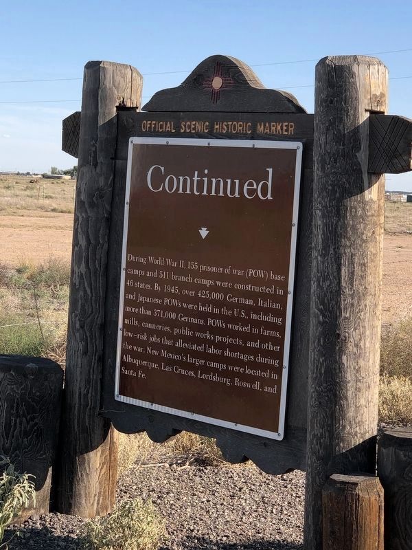
By Duane and Tracy Marsteller, October 9, 2023
Roswell Prisoner of War Camp (Side Two)
| On U.S. 285 0.2 miles south of East Orchard Park Road (County Road 59), on the right when traveling north. |
| On U.S. 285 at milepost 88, on the right when traveling south. |
| On State Road 2 0.5 miles south of East Chicksaw Road, on the left when traveling south. |
| On U.S. 285 1 mile north of State Road 438, on the right when traveling south. |
| On U.S. 70 at milepost 314, on the right when traveling east. |
| On U.S. 380 at milepost 165, on the right when traveling west. |
| On Main Street near E. 4th Street, on the right when traveling north. |
| On Main Street at E. 4th Street, on the right when traveling north on Main Street. |
| On Main Street at E. 4th Street, on the right when traveling north on Main Street. |
| On Main Street at E. 4th Street, on the right when traveling north on Main Street. |
| On North Main Street, on the right when traveling south. |
| On North Pennsylvania Avenue north of West 10th Street, on the right when traveling north. |
| On U.S. 285 at West 11th Street, on the right when traveling south on U.S. 285. |
| On U.S. 380 at milepost 167, on the right when traveling west. |
| Near Campus Circle at West College Boulevard, on the right when traveling west. |
| On Main Street near E. 4th Street, on the left when traveling north. |
| On North Main Street, on the right when traveling south. |
| Near Campus Circle at West College Boulevard when traveling west. |
| On U.S. 380 at milepost 165, on the right when traveling west. |
| On Main Street at E. 4th Street, on the right when traveling north on Main Street. |
| On Main Street at E. 4th Street, on the right when traveling north on Main Street. |
| On North Virginia Avenue, on the left when traveling south. |
| On U.S. 285 0.1 miles north of West College Boulevard, on the left when traveling north. |
| On East Second Street, on the right when traveling west. |
| On North Main Street (U.S. 285) at U.S. 70, on the right when traveling south on North Main Street. |
| On SE Main Street (U.S. 285) 0.4 miles north of East Brasher Road, on the right when traveling north. |
| On North Richardson Avenue, on the right when traveling north. |
| On North Main Street south of West 5th Street, on the right when traveling south. |
| On Main Street near E. 4th Street, on the left when traveling north. |
| On North Main Street, on the right when traveling south. |
| Near West 10th Street 0.1 miles west of North Pennsylvania Avenue. |
| On U.S. 380 at milepost 196, on the right when traveling east. |
| On Relief Route at South Main Street (U.S. 285), on the right when traveling east on Relief Route. |
| On Campus Circle 0.1 miles north of West College Boulevard, on the right when traveling west. |
| On Billy the Kid Drive south of Pecan Drive, on the right when traveling south. |
| On Billy the Kid Drive south of Pecan Drive. |
| On U.S. 60 at milepost 331, on the right when traveling west. Reported permanently removed. |
| On State Road 272 south of State Road 212, on the right when traveling south. |
| On Billy the Kid Drive south of Pecan Drive, on the right when traveling south. |
| On Billy the Kid Drive south of Pecan Drive, on the right when traveling south. |
| On Billy the Kid Drive south of Pecan Drive. |
| On Billy the Kid Drive south of Pecan Drive. |
| On State Road 60 at milepost 329.5, on the left when traveling east. Reported permanently removed. |
| On U.S. 60 at State Road 20, on the right when traveling east on U.S. 60. |
| On U.S. 84 at Billy the Kid Drive, on the right when traveling west on U.S. 84. |
| On U.S. 84 at Billy the Kid Drive, on the right when traveling west on U.S. 84. |
| On Billy the Kid Drive south of Pecan Drive. |
| Near Billy the Kid Road (State Road 272) 0.1 miles south of State Road 212. |
| On Billy the Kid Road (State Road 272) south of State Road 212, on the right when traveling south. Reported permanently removed. |
| On Billy the Kid Drive south of Pecan Drive. |
| On Billy the Kid Drive south of Pecan Drive, on the right when traveling south. |
| On Billy the Kid Drive south of Pecan Drive, on the right when traveling south. |
| On U.S. 84 at State Road 203, on the right when traveling south on U.S. 84. |
| On U.S. 84 west of Cedarpost Road, on the right when traveling west. |
| On West Centre Avenue west of South 17th Street, on the right when traveling west. |
| On 7 Rivers Highway (U.S. 285 at milepost 61) south of East Dayton Road, on the right when traveling south. |
| On Roswell Highway (U.S. 285), on the right when traveling south. |
| On U.S. 285 at milepost 67, on the right when traveling north. |
| On West Main Street at North 2nd Street, on the right when traveling west on West Main Street. |
| On West Main Street at South 3rd Street, on the right when traveling east on West Main Street. |
| On U.S. 82 at U.S. 285, on the right when traveling west on U.S. 82. |
| On West Main Street (U.S. 82) east of South 6th Street, on the right when traveling east. |
| On West Main Street (U.S. 82) east of South 6th Street, on the right when traveling east. |
| On West Main Street (U.S. 82) at South 6th Street, on the right when traveling east on West Main Street. |
| On West Main Street (U.S. 82) at South 6th Street, on the right when traveling east on West Main Street. |
| On North 1st Street (U.S. 285) at East Main Street (U.S. 82), on the right when traveling north on North 1st Street. |
| On Lovington Highway (U.S. 82) 1 mile east of North Haldeman Road (New Mexico Highway 229), on the left when traveling east. |
| On U.S. 285 at milepost 61 south of East Dayton Road, on the right when traveling south. |
| On West Main Street (U.S. 82) at South 8th Street, on the left when traveling west on West Main Street. |
| On West Grand Avenue at South 3rd Street, on the left when traveling west on West Grand Avenue. |
| On West Main Street (U.S. 82) at North 4th Street, on the right when traveling west on West Main Street. |
| On West Quay Avenue at South 9th Street, on the left when traveling west on West Quay Avenue. |
| On North 1st Street (U.S. 285) at East Main Street (U.S. 82), on the right when traveling north on North 1st Street. |
| On South 1st Street (U.S. 285) at East Main Street (U.S. 82), on the right when traveling north on South 1st Street. |
| On West Main Street at South 6th Street, on the right when traveling east on West Main Street. |
| On West Missouri Avenue at South 5th Street, on the right when traveling east on West Missouri Avenue. |
| On North 1st Street (U.S. 285) at East Main Street (U.S. 82), on the right when traveling north on North 1st Street. |
| On West Main Street (U.S. 82) at South 6th Street, on the right when traveling east on West Main Street. |
| On West Richardson Avenue at South 8th Street, on the left when traveling west on West Richardson Avenue. |
| On South Roselawn Avenue at West Missouri Avenue, on the left when traveling south on South Roselawn Avenue. |
| On West Main Street (U.S. 82) east of South 6th Street, on the right when traveling east. |
| On West Texas Avenue at North 8th Street, on the left when traveling west on West Texas Avenue. |
| On West Main Street (U.S. 82) at South 6th Street on West Main Street. |
| On West Main Street (U.S. 82), on the right when traveling west. |
| On U.S. 62 at milepost 16, on the right when traveling west. |
| On U.S. 62 at milepost 10, on the right when traveling west. |
| On West Pierce Street near US 285 (U.S. 285), on the right when traveling south. |
| On Westridge Drive (U.S. 285) at Callaway Drive, on the right when traveling east on Westridge Drive. |
| On U.S. 285 at North 8th Street, on the right when traveling south on U.S. 285. |
| On North Canal Street north of West Mermod Street, on the right when traveling north. Reported missing. |
| On U.S. 285 at State Road 31, on the right when traveling north on U.S. 285. |
| On U.S. 62 at milepost 7.5, on the right when traveling west. |
| On U.S. 62 at milepost 7.5, on the right when traveling west. |
| On East Greene Street (U.S. 62/180) east of Muscatel Avenue, on the right when traveling west. |
| Near State Road 7 6.8 miles west of U.S. 62. |
| On U.S. 285 north of Horizon Road (County Road 719), on the right when traveling north. Reported missing. |
270 entries matched your criteria. The first 100 are listed above.
Next 100 ⊳
