THE HISTORICAL
MARKER DATABASE
“Bite-Size Bits of Local, National, and Global History”


123 entries match your criteria. The first 100 are listed.                                               The final 23 ⊳


King Philip's War 1675-1676 Historical Markers

Markers related to King Philip's War in early Colonial New England from June 1675 through October 1676 (initiated during the 350th anniversary of that war).
 
By Michael Herrick, July 7, 2010
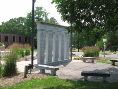
Farmington Veterans Monument
1 ► Connecticut, Capitol Region, Farmington — Farmington Veterans Memorial —
On Montieth Drive at Farmington Avenue (Connecticut Route 4), on the right when traveling east on Montieth Drive.
2 ► Connecticut, Capitol Region, Simsbury, Simsbury Center — Simsbury — (Massaco Plantation) —
On Hopmeadow Street (Connecticut Route 10) at Pent Road, on the left when traveling north on Hopmeadow Street.
3 ► Connecticut, Capitol Region, South Windsor — Bissell Ferry —
On Ferry Lane 0.7 miles west of Main Street, on the right when traveling west.
4 ► Connecticut, Naugatuck Valley Region, Waterbury — First Settlement of Waterbury —
On Highland Avenue at Sunnyside Avenue, on the right when traveling north on Highland Avenue.
5 ► Connecticut, Naugatuck Valley Region, Waterbury — Present Settlement of Waterbury —
On West Main Street at Church Street, on the right when traveling east on West Main Street.
6 ► Connecticut, Northeastern Region, Canterbury — Canterbury —
On S Canterbury Road (Connecticut Route 169) at Westminster Road ( Route 14), on the right when traveling north on S Canterbury Road.
7 ► Connecticut, South Central Region, New Haven, Downtown — Col William Goffe —
Near Temple Street 0.1 miles south of Elm Street, on the right when traveling south.
8 ► Connecticut, South Central Region, Wallingford, Wallingford Center — Hon. Abraham Doolittle —
Near Center Street (Connecticut Route 150) at South Colony Road, on the right when traveling east.
9 ► Connecticut, Southeastern Region, Montville, Uncasville — Montville —
On Norwich-New London Turnpike (Connecticut Route 32) south of Maple Avenue, on the right when traveling south.
10 ► Connecticut, Southeastern Region, Norwich, Norwichtown — John Mason —
On Town Street (Connecticut Route 642) at New London Turnpike, on the right when traveling east on Town Street.
11 ► Maine, Cumberland County, South Portland — Early Settlement —
Near McKernan Drive.
12 ► Maine, Kennebec County, Augusta — Map — Augusta, Maine — The Museum in the Streets —
On Cony Street just west of Arsenal Street, on the left when traveling west.
13 ► Maine, York County, Wells — Laudholm Farm: The foundation of the Wells Reserve —
Near Skinner Mill Road north of Laudholm Farm Road, on the right when traveling north.
14 ► Massachusetts, Barnstable County, Barnstable — Capt. John Gorham House —
On Main Street (Massachusetts Route 6A) east of Ryder Lane, on the left when traveling east.
15 ► Massachusetts, Bristol County, Berkley — Edward Bobbett Slain Here —
On Berkley Street 0.4 miles north of Elm Street, on the right when traveling north.
Paid Advertisement
16 ► Massachusetts, Bristol County, Dighton — Dighton Council Oak — Meeting Place of the Wampanoag Indians —
Near 1996 Elm Street.
17 ► Massachusetts, Bristol County, North Attleborough — Woodcock Burial Ground —
On North Washington Street at Park Street, on the right when traveling south on North Washington Street.
18 ► Massachusetts, Bristol County, Norton — King Philip's Cave —
On Stone Run Drive, in the median.
19 ► Massachusetts, Bristol County, Norton — Winneccunnett Pond Area —
On Bay Road, on the right when traveling north.
20 ► Massachusetts, Bristol County, Rehoboth — Anawan Rock — 1676 —
On U.S. 44 2 miles east of U.S. 118, on the right when traveling east.
21 ► Massachusetts, Bristol County, Rehoboth — Block House No. 2 — From 1675 — as seen in 1782 —
On Barney Avenue at Providence Road, on the right when traveling south on Barney Avenue.
22 ► Massachusetts, Bristol County, South Dartmouth — Russell Garrison Site c. 1664 —
On Fort Street north of Lucy Street, on the left when traveling north.
23 ► Massachusetts, Bristol County, South Dartmouth — The Russell Garrison —
Near Fort Street north of Lucy Street, on the left when traveling north.
24 ► Massachusetts, Bristol County, Swansea — King's Rock — Native American Ceremonial Site — Sachem's Knoll —
On Market Street (Massachusetts Route 136) south of Stoney Hill Road, on the right when traveling south.
25 ► Massachusetts, Bristol County, Swansea — Myles Garrison House Site —
On Old Providence Road at Barneyville Road, on the left when traveling east on Old Providence Road.
26 ► Massachusetts, Bristol County, Swansea, Gardner's Neck — HA-16;902 — Bourne Garrison King Philip's War —
On Gardners Neck Road at Milne Avenue, on the left when traveling south on Gardners Neck Road.
27 ► Massachusetts, Essex County, Danvers — Village Training Field — 1671 —
On Centre Street, on the right when traveling west.
28 ► Massachusetts, Essex County, Gloucester — Stage Fort Fisherman's Field —
Near Western Avenue (Massachusetts Route 127) at Essex Avenue ( Route 133), on the right when traveling north.
29 ► Massachusetts, Franklin County, Gill, Riverside — Captain William Turner —
On Mohawk Trail (Route 2/2A) at Riverview Drive, on the right when traveling east on Mohawk Trail.
30 ► Massachusetts, Franklin County, Greenfield — Capt. William Turner — Town of Greenfield — 1753 —
On Conway Street at Silver Street, on the right when traveling south on Conway Street.
31 ► Massachusetts, Franklin County, Northfield — Captain Richard Beers — 1630 - 1930 —
On Millers Falls Road (Massachusetts Route 63) south of South Mountain Road, on the right when traveling north.
Paid Advertisement
32 ► Massachusetts, Franklin County, Northfield — Indian Council Fires — 1630 - 1930 —
On Millers Falls Road (Massachusetts Route 63) south of Homer Road, on the right when traveling north.
33 ► Massachusetts, Franklin County, Northfield — King Philip's Hill — 1630 - 1930 — Sachem of the Wampanoag —
On Old Bernardston Road, on the left when traveling east.
34 ► Massachusetts, Franklin County, Northfield — First Settlement — 1630 - 1930 —
On Main Street (U.S. 10) south of Maple Street, on the left when traveling north.
35 ► Massachusetts, Franklin County, Northfield — Nathaniel Dickinson —
On Main Street (Massachusetts Route 10/63) south of Pauchaug Ramp Road, on the right when traveling north.
36 ► Massachusetts, Franklin County, South Deerfield — Bloody Brook Monument —
On North Main Street, on the right when traveling north.
37 ► Massachusetts, Franklin County, South Deerfield — Bloody Brook Stone Slab —
On North Main Street, on the right when traveling north.
38 ► Massachusetts, Hampden County, Springfield, Cozy Corner — A Fortified Village of the Agawam Indians —
On Longhill Street (Massachusetts Route 83), on the right when traveling south.
39 ► Massachusetts, Hampden County, Springfield, Metro Center — The “Old Fort” in Early Springfield — Location ~ Fort and Main Street —
On Fort Street north of E Columbus Avenue, on the left when traveling north.
40 ► Massachusetts, Hampden County, Springfield, South End — Lieut. Thomas Cooper and Constable Thomas Miller —
On Mill Street at Main Street, on the right when traveling east on Mill Street.
41 ► Massachusetts, Hampshire County, Hatfield — Hatfield — 1630 - 1930 —
On Elm Court near Interstate 91, on the right when traveling east.
42 ► Massachusetts, Middlesex County, Framingham — Site of Eames Massacre —
On Chatauqua Avenue when traveling north.
43 ► Massachusetts, Middlesex County, Framingham — Thomas Eames —
On Dudley Road at Mt. Wayte Avenue, on the right when traveling north on Dudley Road.
44 ► Massachusetts, Middlesex County, Groton — Groton — 1630 - 1930 —
On Main Street (Massachusetts Route 119), on the left when traveling south.
45 ► Massachusetts, Middlesex County, Groton — Parker House — 1630 - 1930 —
On Main Street (Massachusetts Route 119), on the left when traveling south.
46 ► Massachusetts, Middlesex County, Marlborough — 24 — Artemas Ward Park — Marlborough, Massachusetts — The Museum in the Streets® —
On Windsor Street south of Main Street, on the right when traveling south.
47 ► Massachusetts, Middlesex County, Marlborough — High School Common —
On Rawlins Avenue at Main Street (U.S. 20), on the right when traveling north on Rawlins Avenue.
Paid Advertisement
48 ► Massachusetts, Middlesex County, Marlborough — 4 — Old Common Cemetery — Marlborough, Massachusetts — The Museum in the Streets —
On Central Street at Prospect Street, on the right when traveling east on Central Street.
49 ► Massachusetts, Middlesex County, Marlborough — 9 — The Evolution of Marlborough (1656-2019) — Marlborough, Massachusetts — The Museum in the Streets® —
Near Main Street west of Court Street, on the right when traveling west.
50 ► Massachusetts, Middlesex County, Marlborough — 3 — The First Meeting House & The Old Common — Marlborough, Massachusetts — The Museum in the Streets —
On Rawlins Avenue at Main Street, on the left when traveling south on Rawlins Avenue.
51 ► Massachusetts, Middlesex County, Marlborough — 23 — The Parade of Colonial History — Marlborough, Massachusetts — The Museum in the Streets® —
On Main Street at Windsor Street, on the right when traveling east on Main Street.
52 ► Massachusetts, Middlesex County, Marlborough — 6 — The Praying Indians — Marlborough, Massachusetts — The Museum in the Streets —
On Prospect Street at West Main Street, on the right when traveling south on Prospect Street.
53 ► Massachusetts, Middlesex County, Natick — Indian Meetinghouse — 1630 - 1930 —
On Eliot Street (Massachusetts Route 16) at Union Street, on the left when traveling north on Eliot Street.
54 ► Massachusetts, Middlesex County, Sudbury — Capt. Samuel Wadsworth — of Milton —
On Concord Road south of Codjer Lane, on the left when traveling south.
55 ► Massachusetts, Middlesex County, Sudbury — Goodenow Garrison House Site —
On Boston Post Road (Massachusetts Route 20) 0.1 miles west of Goodman’s Hill Road, on the left when traveling west.
56 ► Massachusetts, Middlesex County, Sudbury — Haynes Garrison House —
On Water Row at Old Sudbury Road (State Route 27), on the left when traveling north on Water Row.
57 ► Massachusetts, Middlesex County, Sudbury — Men of the Sudbury Fight Monument —
Near Concord road south of Codjer Lane, on the left when traveling south.
58 ► Massachusetts, Middlesex County, Sudbury — Sudbury Fight — 1630 - 1930 —
On Boston Post Road (U.S. 20) at Concord Road, on the right when traveling west on Boston Post Road.
59 ► Massachusetts, Middlesex County, Sudbury — The Goodnow Garrison House — 1630 - 1930 —
On Boston Post Road (U.S. 20) just west of Goodmans Hill Road, on the left when traveling west.
60 ► Massachusetts, Middlesex County, Wayland — Old Town Bridge — Near Here are Buried —
Near Old Sudbury Road (Route 27), on the right when traveling north.
61 ► Massachusetts, Norfolk County, Canton — Ponkapoag Plantation — 1630 - 1930 —
On Washington Street (Massachusetts Route 138) south of Homans Lane, on the right when traveling south.
62 ► Massachusetts, Norfolk County, Medfield — Peak House — 1630 - 1930 —
On Main Street (Massachusetts Route 109) at Pound Street, on the right when traveling west on Main Street.
63 ► Massachusetts, Norfolk County, Sharon, King Philip’s Rock Trails Conservation Area — King Philip’s Rock —
Near Mansfield Road east of East Foxboro Road, on the left when traveling east.
Paid Advertisement
64 ► Massachusetts, Norfolk County, Weymouth — The Last Indian Attack —
On Washington Street (Massachusetts Route 53) at Winter Court, on the right when traveling east on Washington Street.
65 ► Massachusetts, Plymouth County, Halifax — Lieut. John Tomson Home Site —
On Thompson Street (Massachusetts Route 105) near Orchard Circle, on the left when traveling south.
66 ► Massachusetts, Plymouth County, Middleborough — Francis Miller —
On Plympton Street (Massachusetts Route 105) south of U.S. 44, on the left when traveling south.
67 ► Massachusetts, Plymouth County, Middleborough — In Memory of John Miller —
On Plympton Street (Massachusetts Route 105) near U.S. 44, on the left when traveling south.
68 ► Massachusetts, Plymouth County, Middleborough — Old Fort —
On North Main Street (Massachusetts Route 105) at Barrows Street, on the right when traveling north on North Main Street.
69 ► Massachusetts, Plymouth County, Plymouth — First Fort —
Near School Street, on the left when traveling north.
70 ► Massachusetts, Plymouth County, Plymouth — Jabez Howland House — 1667 —
On Sandwich Street, on the left when traveling east.
71 ► Massachusetts, Plymouth County, Plymouth — Metacomet (King Philip) —
On Main Street at Town Square, on the left when traveling north on Main Street.
72 ► Massachusetts, Plymouth County, Scituate — First Training Field — 1636 —
On Stockbridge Road at Meeting House Lane, on the right when traveling south on Stockbridge Road.
73 ► Massachusetts, Plymouth County, Scituate — Site of Stockbridge Mansion — 1630 - 1930 —
On Country Way just north of the Greenbush Rotary, on the left when traveling north.
74 ► Massachusetts, Plymouth County, Scituate — Williams-Barker House — 1630 - 1930 —
On Barker Road 0.1 miles north of Brookline Road, on the right when traveling north.
75 ► Massachusetts, Plymouth County, West Bridgewater — Home of Rev. James Keith —
On River Street east of Forest Street, on the right when traveling west.
76 ► Massachusetts, Suffolk County, Boston, D Street / West Broadway — Boston Harbor Islands — A national park area —
On Northern Avenue at Harborwalk, on the right when traveling west on Northern Avenue.
77 ► Massachusetts, Suffolk County, Boston, D Street / West Broadway — From Paradise to Prison — South Boston —
Near Head Island Causeway south of Harborwalk, on the right when traveling south.
78 ► Massachusetts, Worcester County, Brookfield — Foster Hill Road — West Brookfield —
On West Main Street (State Road 9) near West Brookfield Road, on the left when traveling east.
79 ► Massachusetts, Worcester County, Brookfield — Brookfield — 1630 -- 1930 —
On East Main Street (Massachusetts Route 9) west of West Brookfield Road, on the right when traveling west.
Paid Advertisement
80 ► Massachusetts, Worcester County, Grafton — Hassanamesit — 1630 - 1930 —
On Grafton Common at Worcester Street ( Route 140), on the right when traveling east on Grafton Common.
81 ► Massachusetts, Worcester County, Lancaster — Rowlandson Rock —
Near Winsor Road east of George Hill Road, on the left when traveling east.
82 ► Massachusetts, Worcester County, Lancaster, South Lancaster — Rowlandson Rock — 1630 - 1930 —
On Main Street (Massachusetts Route 70) at Sterling Road, on the right when traveling south on Main Street.
83 ► Massachusetts, Worcester County, Lancaster, South Lancaster — Site of Mary Rowlandson’s Capture —
On Main Street (Massachusetts Route 70) north of Bigelow Gardens, on the left when traveling north.
84 ► Massachusetts, Worcester County, Mendon — First Meeting House — 1630 - 1930 —
On Main Street at Hastings Street ( Route 16), on the left when traveling north on Main Street.
85 ► Massachusetts, Worcester County, Mendon — Founders’ Park —
On Main Street at Hastings Street ( Route 16), on the left when traveling north on Main Street.
86 ► Massachusetts, Worcester County, Mendon — Mendon’s First Meeting House —
On Hastings Street (Massachusetts Route 16) at Main Street, on the right when traveling east on Hastings Street.
87 ► Massachusetts, Worcester County, Mendon — Near This Spot —
On Providence Street at Hartford Avenue E., on the right when traveling south on Providence Street.
88 ► Massachusetts, Worcester County, New Braintree — Capt. Edward Hutchinson and His Company —
On West Road 0.3 miles north of Unitas Road, on the right when traveling north.
89 ► Massachusetts, Worcester County, New Braintree — Sarah P. Rowlandson — Shot by Indians at Lancaster; Taken to Winnimissett —
On Hardwick Road at Ravine Road, on the left when traveling east on Hardwick Road.
90 ► Massachusetts, Worcester County, New Braintree — Wheeler’s Surprise — 1630 – 1930 —
On Barre Road (Massachusetts Route 67) at Daniel Whitney Road, on the right when traveling north on Barre Road.
91 ► Massachusetts, Worcester County, Princeton — Site of Mary Rowlandson’s Release —
Near Midstate Trail south of Redemption Rock Trail North ( Route 140), on the left when traveling south.
92 ► Massachusetts, Worcester County, West Brookfield, Quaboag Plantation — John Ayres — Killed by Indians 2d - 1675 - Aug. —
On Foster Hill Road 0.1 miles west of George Allen Road, on the right when traveling west.
93 ► Massachusetts, Worcester County, West Brookfield, Quaboag Plantation — The First and Second Meeting Houses —
On Foster Hill Road west of George Allen Road, on the right when traveling west.
94 ► Massachusetts, Worcester County, West Brookfield, Quaboag Plantation — The Fortified House —
On Foster Hill Road just west of George Allen Road, on the left when traveling west.
95 ► Massachusetts, Worcester County, West Brookfield, Quaboag Plantation — The Well —
On Foster Hill Road just west of George Allen Road, on the left when traveling west.
Paid Advertisement
96 ► Massachusetts, Worcester County, West Brookfield, Quaboag Plantation — Thomas and Mary Millett’s Home Site —
On Foster Hill Road 0.1 miles west of George Allen Road, on the right when traveling west.
97 ► Massachusetts, Worcester County, Worcester — Worcester — 1630 - 1930 —
On Belmont Street (Massachusetts Route 9) at Shrewsbury Street, on the left when traveling west on Belmont Street.
98 ► Massachusetts, Worcester County, Worcester, Lake Park — Wigwam Hill — 1630 - 1930 —
On Belmont Street (Massachusetts Route 9), on the right when traveling west.
99 ► New Hampshire, Strafford County, Dover — 2 — Dover's Early Settlers — The Cochecho Massacre —
On Central Avenue (New Hampshire Route 9) south of First Street, on the right when traveling south.
100 ► New York, Westchester County, Rye — Old Rye Fort 1675 —
On Boston Post Road (U.S. 1 at milepost 25).

123 entries matched your criteria. The first 100 are listed above. The final 23 ⊳
 
 
CeraNet Cloud Computing sponsors the Historical Marker Database.
This website earns income from purchases you make after using our links to Amazon.com. We appreciate your support.
Paid Advertisement
Nov. 13, 2026
