411 entries match your criteria. The first 100 are listed. ⊳
Historical Markers and War Memorials on the Gulf Coast Region
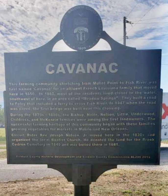
October 10, 2022
Cavanac Marker
1 ► Alabama, Baldwin County, Barnwell — Barnwell / Cavanac —  |
| On County Road 3 0.7 miles east of Greeno Road (U.S. 98), on the right when traveling east. | |||
| 2 ► Alabama, Baldwin County, Bay Minette — A County Older Than the State, Baldwin County — |
| On Courthouse Square (U.S. 31) at Hand Avenue, on the left when traveling east on Courthouse Square. | |||
| 3 ► Alabama, Baldwin County, Bay Minette — Baldwin County Eternal Flame Veterans Memorial — |
| On Courthouse Square (U.S. 31) at D'Olive Street, on the left when traveling east on Courthouse Square. | |||
| 4 ► Alabama, Baldwin County, Bay Minette — Bay Minette Korean War Memorial — |
| On Hall Avenue (U.S. 31) at D'Olive Street on Hall Avenue. | |||
| 5 ► Alabama, Baldwin County, Bay Minette — Bay Minette, Alabama — |
| On West 2nd Street east of McMillan Avenue, on the right when traveling east. | |||
| 6 ► Alabama, Baldwin County, Bay Minette — Bottle Creek Site — |
| On Courthouse Square (U.S. 31) at Hand Avenue, on the left when traveling east on Courthouse Square. | |||
| 7 ► Alabama, Baldwin County, Bay Minette — Judge Harry Toulmin — (1766 – 1823) — |
| On Courthouse Square (U.S. 31) at Hand Avenue, on the left when traveling west on Courthouse Square. | |||
| 8 ► Alabama, Baldwin County, Bay Minette — Lynching in America / The Lynching of Rueben Sims — Community Remembrance Project — |
| On Courthouse Square at U.S. 31, on the left when traveling north on Courthouse Square. | |||
| 9 ► Alabama, Baldwin County, Bay Minette — Stephen J. Boykin / The American Banner — |
| On Shedrick Hardy Parkway 0.1 miles south of Rain Drive, on the right when traveling south. | |||
| 10 ► Alabama, Baldwin County, Blakeley — Alabama — |
| On Washington Avenue south of Old Blakeley Road, on the right when traveling south. | |||
| 11 ► Alabama, Baldwin County, Blakeley — Battle of Blakeley — April 9, 1865 — |
| On Washington Avenue south of Old Blakeley Road, on the right when traveling south. | |||
| 12 ► Alabama, Baldwin County, Blakeley — Fort Blakeley (Blakely*) — |
| Near Battlefield Road 0.3 miles east of Green Street, on the right when traveling east. | |||
| 13 ► Alabama, Baldwin County, Blakeley — Redoubt Six — |
| On Old Blakeley Road, on the right when traveling south. | |||
| 14 ► Alabama, Baldwin County, Blakeley — Ruins of the original Foundation of Baldwin County's First Courthouse |
| On Franklin Street, on the right when traveling north. Reported permanently removed. | |||
| 15 ► Alabama, Baldwin County, Blakeley — Site of Baldwin County's First Courthouse — |
| On Franklin Street north of Washington Avenue, on the right when traveling north. | |||
| 16 ► Alabama, Baldwin County, Blakeley — The Apalachee Village — |
| On Franklin Street 0.4 miles north of Washington Avenue, on the right when traveling west. | |||
| 17 ► Alabama, Baldwin County, Blakeley — The Battle of Fort Blakeley — |
| On Battlefield Road 0.3 miles east of Green Street. | |||
| 18 ► Alabama, Baldwin County, Blakeley — The Battle of Fort Blakely — |
| On Battlefield Road 0.8 miles east of Green Street, on the right when traveling north. | |||
| 19 ► Alabama, Baldwin County, Blakeley — The Bottle Creek Site — Alabama Indigenous Mound Trail — |
| On Franklin Street 0.4 miles north of Washington Avenue, on the right when traveling west. | |||
| 20 ► Alabama, Baldwin County, Blakeley — The Siege of Fort Blakeley — |
| On Battlefield Road, on the left when traveling east. | |||
| 21 ► Alabama, Baldwin County, Blakeley — The Town of Blakeley — |
| On Franklin Street 0.1 miles north of Washington Avenue, on the left when traveling north. | |||
| 22 ► Alabama, Baldwin County, Blakeley — The United States Colored Troops (USCT) at the Battle of Fort Blakeley — |
| On Battlefield Road, on the left when traveling east. | |||
| 23 ► Alabama, Baldwin County, Blakeley — Union Artillery Batteries — |
| On Union Trail Loop west of Old Blakeley Road, on the left. | |||
| 24 ► Alabama, Baldwin County, Bon Secour — The Charles Swift Family / Swift Coles Historic Home — |
| On County Road 49 at Swift Coles Lane, on the left when traveling south on County Road 49. | |||
| 25 ► Alabama, Baldwin County, Bon Secour — Stop 3 — Vicinity of Salt Works and Camp Anderson — “Salt Is Eminently Contraband” — Civil War Trail Battle for Mobile Bay — |
| On River Road 0.2 miles west of Bon Secour Highway, on the left when traveling west. | |||
| 26 ► Alabama, Baldwin County, Daphne — 1814 - 1977 — General Andrew Jackson — |
| On Main Street south of Bayfront Park Drive, on the right when traveling south. | |||
| 27 ► Alabama, Baldwin County, Daphne — City of Daphne — Incorporated July 8, 1927 — |
| On Main Street at Manci Avenue, on the right when traveling south on Main Street. | |||
| 28 ► Alabama, Baldwin County, Daphne — Colonia Italiana 1888-The Beautiful Forest / The Founding Fathers of the Italian Colony — |
| On Daphne Road (County Road 64) near State Route 181, on the right when traveling west. | |||
| 29 ► Alabama, Baldwin County, Daphne — Daphne United Methodist Church — |
| Near 6th Avenue. | |||
| 30 ► Alabama, Baldwin County, Daphne — Fuller Memorial Park — |
| On Patrician Drive W 0.1 miles north of Patrician Drive S, in the median. | |||
| 31 ► Alabama, Baldwin County, Daphne — Little Bethel Baptist Church: — |
| On Main Street (County Road 98) at Magnolia Avenue, on the right when traveling north on Main Street. | |||
| 32 ► Alabama, Baldwin County, Daphne — Patriot's Point Memorial — |
| Near U.S. 98 at Whispering Pines Road. | |||
| 33 ► Alabama, Baldwin County, Daphne — The Eastern Shore Trail — |
| On N Main St. | |||
| 34 ► Alabama, Baldwin County, Daphne — The Village — |
| On Main Street south of U.S. 89. | |||
| 35 ► Alabama, Baldwin County, Daphne — Yancey Crane Cemetery — Baldwin County — |
| On U.S. 98 north of Whispering Pines Road, on the right when traveling north. | |||
| 36 ► Alabama, Baldwin County, Elsanor — Elsanor — |
| On U.S. 90 at Thelma Burke Road/Poplar Road, on the right when traveling west on U.S. 90. | |||
| 37 ► Alabama, Baldwin County, Fairhope — Brodbeck and Zundel General Merchandise Store — |
| On Scenic Highway 98 (Alternate U.S. 98) near Zundel Road, on the right when traveling south. | |||
| 38 ► Alabama, Baldwin County, Fairhope — City of Fairhope — |
| On North Section Street north of Fairhope Ave, on the right when traveling north. | |||
| 39 ► Alabama, Baldwin County, Fairhope — Confederate Rest Cemetery — |
| On Pine Grove Drive near Confederate Rest Road, on the right when traveling west. | |||
| 40 ► Alabama, Baldwin County, Fairhope — Craig Turner Sheldon — 1917-1997 — |
| On 24 N Section Street. | |||
| 41 ► Alabama, Baldwin County, Fairhope — Fairhope Colony Cemetery — 1895 / Historic Site — |
| On Oak Avenue at N Church Street, on the right when traveling west on Oak Avenue. | |||
| 42 ► Alabama, Baldwin County, Fairhope — Fairhope Museum of History — |
| On 24 N Section Street at Fairhope Avenue, on the right when traveling north on 24 N Section Street. | |||
| 43 ► Alabama, Baldwin County, Fairhope — Land, Capital, Labor — |
| On N Beach Road. | |||
| 44 ► Alabama, Baldwin County, Fairhope — Marietta Johnson — |
| On South Mobile Street. | |||
| 45 ► Alabama, Baldwin County, Fairhope — Nancy Lewis / Stewart the Picture Man — |
| On South Bancroft Street, on the left when traveling south on South Bancroft Street. | |||
| 46 ► Alabama, Baldwin County, Fairhope — Tears of Sorrow — Tears of Joy — |
| On N Beach Road. | |||
| 47 ► Alabama, Baldwin County, Fairhope — Welcome to the Fairhope Pier — Fairhope’s ‘town square’ — |
| On 4 N Beach Road. | |||
| 48 ► Alabama, Baldwin County, Fairhope, Montrose Historic District — Ecor Rouge — |
| On Eastern Shore Trail south of Taylor Street, on the left when traveling north. | |||
| 49 ► Alabama, Baldwin County, Foley — City of Foley — |
| On East Laurel Avenue. | |||
| 50 ► Alabama, Baldwin County, Foley — City of Foley Camellia Walk — |
| On North McKenzie Street near Laurel Avenue. | |||
| 51 ► Alabama, Baldwin County, Foley — Cobb's Light — |
| On Alabama Route 59, on the left when traveling south. | |||
| 52 ► Alabama, Baldwin County, Fort Morgan — Colors of Significance: Historic Flags of Mobile Point — |
| Near Fort Morgan Road (Alabama Route 180) 2 miles west of Dune Drive, on the left when traveling west. | |||
| 53 ► Alabama, Baldwin County, Fort Morgan — First Battle of Fort Bowyer — September 14, 1814 — |
| Near Fort Morgan Road (Alabama Route 180) 2 miles west of Dune Drive, on the right when traveling west. | |||
| 54 ► Alabama, Baldwin County, Fort Morgan — Fort Bowyer — 1813-1821 — |
| On Fort Morgan Road (Alabama Route 180) 2 miles west of Dune Drive, on the right when traveling west. | |||
| 55 ► Alabama, Baldwin County, Fort Morgan — Noble Leslie DeVotie — |
| Near Dixie Graves Parkway (State Highway 180) when traveling west. | |||
| 56 ► Alabama, Baldwin County, Fort Morgan — Second Battle of Fort Bowyer — February 8-12, 1815 — |
| On Fort Morgan Road (Alabama Route 180) 2 miles west of Dune Drive, on the left when traveling west. | |||
| 57 ► Alabama, Baldwin County, Fort Morgan — The Battery Bailey — Position of the 2nd Connecticut Light Artillery August 20-25, 1864 — |
| Near Fort Morgan Road (Alabama Route 180) 2 miles west of Dune Drive, on the right when traveling west. | |||
| 58 ► Alabama, Baldwin County, Fort Morgan — The Pride of Seven Flags — |
| On Dixie Graves Parkway near Route 180 W. | |||
| 59 ► Alabama, Baldwin County, Gulf Shores — "Damn The Torpedoes!" The Campaigns for Mobile, 1864 - 1865 — |
| On Fort Morgan Road (Alabama Route 180) 1.2 miles west of Dune Road, on the right when traveling west. | |||
| 60 ► Alabama, Baldwin County, Gulf Shores — Stop C4 — "The Shells Were Bursting All Around Us" — The Siege of Fort Morgan: — Stop C4 — |
| Near Fort Morgan Road 1.4 miles Dune Road, on the left when traveling west. | |||
| 61 ► Alabama, Baldwin County, Gulf Shores — 32 Pounder Sea Coast Defense Gun — On Barbette Carriage — |
| Near Fort Morgan Road (Alabama Route 180) 1.6 miles west of Dune Road, on the right when traveling west. | |||
| 62 ► Alabama, Baldwin County, Gulf Shores — 6.4” (100 pounder) Parrott Rifle / 7” Brooke Rifle — |
| On Fort Morgan Road (Road 180) 1.7 miles west of Dune Drive, on the right when traveling west. | |||
| 63 ► Alabama, Baldwin County, Gulf Shores — Alabama’s Coastal Connection — Bon Secour National Wildlife Refuge — Little Lagoon and Gator Lake — |
| Near Fort Morgan Road (State Road 180) east of Mobile Street. | |||
| 64 ► Alabama, Baldwin County, Gulf Shores — Battery Dearborn (1900-1924) — |
| Near Fort Morgan Road (State Road 180) 1 mile west of Dune Drive, on the left when traveling west. | |||
| 65 ► Alabama, Baldwin County, Gulf Shores — Battery Schenck (1899-1923) — |
| On Fort Morgan Road (State Road 180) 1.7 miles west of Dune Drive, on the right when traveling west. | |||
| 66 ► Alabama, Baldwin County, Gulf Shores — Battery Thomas (1898-1917) — |
| Near Fort Morgan Road (State Road 180) 1.7 miles west of Dune Drive. | |||
| 67 ► Alabama, Baldwin County, Gulf Shores — Camp Withers — |
| Near West Fort Morgan Road (Alabama Route 180) at Island Club Drive, on the right when traveling west. | |||
| 68 ► Alabama, Baldwin County, Gulf Shores — Citadel (1825-1865) — |
| Near Fort Morgan Road (Alabama Route 180) 1.7 miles west of Dune Drive when traveling west. | |||
| 69 ► Alabama, Baldwin County, Gulf Shores — Fort Bowyer War of 1812 — |
| On Dixie Graves Highway, on the right when traveling south. | |||
| 70 ► Alabama, Baldwin County, Gulf Shores — Gulf Shores Community — |
| On Sutton Place at Gulf Place, on the right when traveling south on Sutton Place. | |||
| 71 ► Alabama, Baldwin County, Gulf Shores — Here ends the Alabama Scenic River Trail — |
| Near Fort Morgan Road (Alabama Route 180) 1.2 miles west of Dune Drive, on the right when traveling west. | |||
| 72 ► Alabama, Baldwin County, Gulf Shores — Indian Village Achuse — |
| On Alabama Route 180 east of Gasque Lane, on the right when traveling west. | |||
| 73 ► Alabama, Baldwin County, Gulf Shores — 16 — Lafayette’s Tour — Mapping the Farewell Tour — The Lafayette Trail — |
| On Fort Morgan Road (State Road 180) west of Burgoyne Road, on the right when traveling west. | |||
| 74 ► Alabama, Baldwin County, Gulf Shores — Navy Cove / Pilot Town — |
| On Fort Morgan Road (Alabama Route 180) west of Pontoon Lane, on the right when traveling west. | |||
| 75 ► Alabama, Baldwin County, Gulf Shores — Officer’s Row — |
| On Fort Morgan Road (State Road 180) 1.3 miles west of Dune Drive, on the left when traveling west. | |||
| 76 ► Alabama, Baldwin County, Gulf Shores — Panama Mount — |
| Near Fort Morgan Road (Alabama Route 180) 1.7 miles west of Dune Drive (Route 180). | |||
| 77 ► Alabama, Baldwin County, Gulf Shores — Peace Magazine (1902-1924) — |
| Near Fort Morgan Road (State Road 180) 1 mile west of Dune Drive, on the left when traveling west. | |||
| 78 ► Alabama, Baldwin County, Gulf Shores — Post Hospital Complex — |
| Near Fort Morgan Road (Alabama Route 180) 1.2 miles west of Dune Road, on the right when traveling west. | |||
| 79 ► Alabama, Baldwin County, Gulf Shores — The Battery Lincoln — Position of Company “C” of the 20th Iowa Infantry — |
| Near Fort Morgan Road (State Road 180) 1.3 miles west of Dune Drive, on the left when traveling west. | |||
| 80 ► Alabama, Baldwin County, Gulf Shores — Stop C1 — The Battle of Mobile Bay — “A Deadly Rain of Shot and Shell” — Civil War Trail, Battle for Mobile Bay — |
| Near Fort Morgan Road (State Highway 180) 1.7 miles west of Dune Drive. | |||
| 81 ► Alabama, Baldwin County, Gulf Shores — Stop C2 — The Battle of Mobile Bay — “Now I Am In The Humor, I Will Have It Out!” — Civil War Trail, Battle for Mobile Bay — |
| Near Fort Morgan Road (State Highway 180) 1.7 miles west of Dune Drive. | |||
| 82 ► Alabama, Baldwin County, Gulf Shores — Stop C3 — The Battle of Mobile Bay — “Damn the Torpedoes!” — Civil War Trail, Battle for Mobile Bay — |
| Near Fort Morgan Road (Alabama Route 180) 1.7 miles west of Dune Drive when traveling west. | |||
| 83 ► Alabama, Baldwin County, Gulf Shores — The Citadel — (1821-1865) — |
| Near Fort Morgan Road (Alabama Route 180) 1.7 miles west of Dune Drive when traveling west. | |||
| 84 ► Alabama, Baldwin County, Gulf Shores — The Overland Campaign — Storm Clouds Gather — Civil War Trail, Battle for Mobile Bay — |
| On Fort Morgan Road (State Road 180) 1.7 miles west of Dune Drive, on the left when traveling west. | |||
| 85 ► Alabama, Baldwin County, Gulf Shores — U.S. Model 1918M1 155mm Gun and Model 1918A1 Carriage — |
| On Fort Morgan Road (State Road 180) 1.7 miles west of Dune Drive, on the right when traveling west. | |||
| 86 ► Alabama, Baldwin County, Josephine — Josephine — |
| On Josephine Drive, on the right when traveling east. | |||
| 87 ► Alabama, Baldwin County, Little River — “The Red Eagle” William Weatherford / Sehoy Tate Weatherford Princess — |
| On Red Eagle Road 0.1 miles west of T.J. Earle Road, in the median. | |||
| 88 ► Alabama, Baldwin County, Lottie — History of Lottie, Alabama — |
| On Jack Springs Road at Lottie Road (County Road 61), on the right when traveling south on Jack Springs Road. | |||
| 89 ► Alabama, Baldwin County, Loxley — Dedicated by the Town of Loxley — |
| On North Hickory Street (U.S. 90) at Municipal Park Drive on North Hickory Street. | |||
| 90 ► Alabama, Baldwin County, Loxley — Jenkins Farm / Jenkins Farmhouse — |
| On Jenkins Farm Road 0.2 miles east of U.S. 90, on the right when traveling east. | |||
| 91 ► Alabama, Baldwin County, Loxley — The Town of Loxley — |
| On North Hickory Street at Municipal Park Drive, on the right when traveling south on North Hickory Street. | |||
| 92 ► Alabama, Baldwin County, Magnolia Springs — Magnolia Springs, Alabama — |
| On Oak Street west of Magnolia Springs Highway, on the right when traveling west. | |||
| 93 ► Alabama, Baldwin County, Magnolia Springs — The Springs — |
| Near Magnolia Springs Highway (County Route 49) 0.1 miles east of Oak Street. | |||
| 94 ► Alabama, Baldwin County, Montrose — The Village of Montrose / Montrose — |
| On Sibley Street 0.1 miles west of U.S. 98, on the left when traveling west. | |||
| 95 ► Alabama, Baldwin County, Orange Beach — Bay Circle — |
| On Canal Road at Bay Circle, on the right when traveling west on Canal Road. | |||
| 96 ► Alabama, Baldwin County, Orange Beach — Hugh S. Branyon Backcountry Trail System — |
| On Orange Beach Boulevard (State Highway 161) at Catman Road, on the right when traveling south on Orange Beach Boulevard. | |||
| 97 ► Alabama, Baldwin County, Orange Beach — Orange Beach Community Cemetery — “Bear Point Cemetery” — Baldwin County — |
| On Canal Road (Alabama Route 180) at Pensacola Avenue, on the right when traveling east on Canal Road. | |||
| 98 ► Alabama, Baldwin County, Orange Beach — Orange Beach Municipal Complex — |
| On Orange Beach Boulevard (Alabama Route 161) at John M Snook Drive, on the right when traveling south on Orange Beach Boulevard. | |||
| 99 ► Alabama, Baldwin County, Orange Beach — Orange Beach, Alabama — |
| On Canal Road east of Nancy Lane, on the left when traveling east. | |||
| 100 ► Alabama, Baldwin County, Orange Beach — Perdido Pass — |
| On Perdido Beach Boulevard (Alabama Route 182) east of Parkway Drive, on the right when traveling east. | |||
411 entries matched your criteria. The first 100 are listed above. Next 100 ⊳