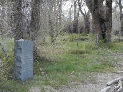
By Barry Swackhamer, May 28, 2016
Old Rock Creek Stage Crossing Marker
| On Elk Mountain-Arlington Road near Interstate 80 when traveling south. |
| On Wyoming Route 70, on the left when traveling east. |
| On Rattlesnake Pass Road near Interstate 80. |
| On Elk Mountain-Arlington Road (County Route 402) near Interstate 80, on the left when traveling west. |
| On East Main Street (County Route 72) at Elk Mountain-Medicine Bow Road (County Route 402), on the left when traveling south on East Main Street. |
| Near Interstate 80 at Elk Mountain Arlington Road. |
| Near Interstate 80 at Elk Mountain Arlington Road. |
| On Interstate 80 at Elk Mountain Arlington Road on Interstate 80. |
| On Freeman Avenue at 6th Street ( Route 70), on the left when traveling north on Freeman Avenue. |
| On McCaffrey Avenue (State Highway 70) near 2nd Street, on the left when traveling north. |
| On Winchell Avenue at 6th Street ( Route 70), on the right when traveling north on Winchell Avenue. |
| On Wyoming 70 (State Highway 70), on the left when traveling west. |
| On Winchell Avenue, on the right when traveling north. |
| On U.S. 30 near Medicine Bow-McFadden Road. |
| On U.S. 30 near Medicine Bow-McFadden Road, on the left when traveling west. |
| On State Highway 220 near U.S. 287, on the right when traveling north. |
| On West Walnut Street at 10th Street, on the right when traveling east on West Walnut Street. |
| On 5th Street near West Buffalo Avenue, on the right when traveling west. |
| On U.S. 287 near Gun Club Road, on the left when traveling north. |
| Near W. Davis Street at Bennett Street, on the right when traveling south. |
| Near West Pine Street at 5th Street, on the right when traveling west. |
| On West Walnut Street near 4th Street, on the right when traveling west. |
| On State Highway 130 44.9 miles west of the Laramie exit (Interstate 80), on the right when traveling east. |
| On East Bridge Avenue near North 1st Street ( Highway 130), on the right when traveling east. |
| On Unnamed Road 0.5 miles north of Saratoga Lake Campground Road, on the left when traveling north. |
| On State Highway 130 0.7 miles south of Pass Creek Rd, on the right when traveling south. |
| On Wyoming 487, on the left when traveling south. |
| On Wyoming 487, on the right when traveling north. |
| On County Route 347 near Interstate 80, on the right when traveling north. |
| Near County Route 347 near Interstate 80. |
| On County Route 347 near Interstate 80, on the right when traveling north. |
| On County Route 347 near Interstate 80, on the right when traveling north. |
| Near County Route 347 near Interstate 80. |
| On County Route 347 near Interstate 80, on the right when traveling north. |
| On Lincoln Avenue (State Highway 76) near 6th Street, in the median. |
| Near County Route 347 near Interstate 80, on the left when traveling north. |
| Near County Route 347 near Interstate 80, on the right when traveling west. |
| On County Route 347 near Interstate 80, on the right. |
| Near Old Highway 0.1 miles east of County Road 347, on the left when traveling east. |
| Near County Road 347 1.7 miles north of Old Highway. |
| On County Route 347 near Interstate 80, on the right when traveling west. |
| Near County Route 347 near Interstate 80, on the left when traveling north. |
| Near County Route 347 near Interstate 80, on the right when traveling west. |
| On County Route 347 near Interstate 80, on the right when traveling west. |
| On County Route 347 near Interstate 80, on the right when traveling west. |
| On County Route 347 near Interstate 80, on the right when traveling west. |
| On County Route 374 near Interstate 80, on the right when traveling north. |
| Near County Route 347 near Interstate 80, on the right when traveling west. |
| Near State Highway 347 near Interstate 80, on the right when traveling west. |
| On County Route 347 near Interstate 80, on the right when traveling north. |
| On State Highway 374 near Interstate 80, on the right when traveling north. |
| On County Route 347 near Interstate 80, on the right when traveling north. |
| Near Old Highway 0.1 miles east of County Road 347, on the left when traveling east. |
| On County Route 347 near Interstate 80, on the right when traveling north. |
| On Route 347 near Interstate 80, on the right. |
| On County Route 347 near Interstate 80, on the right when traveling north. |
| On County Route 347 near Interstate 80, on the right when traveling north. |
| On County Route 347 near Interstate 80, on the right when traveling west. |
| On Lincoln Avenue near 4th Street, in the median. |
| On County Route 347 near Interstate 80, on the right when traveling west. |
| On County Route 347 near Interstate 80. |
| On State Highway 347 near County Route 80. |
| Near County Route 374 near Interstate 80. |
| Near County Road 347 1.7 miles north of Old Highway. |
| On County Route 347 near 80, on the right when traveling west. |
| Near Old Highway 0.1 miles east of County Road 347, on the left when traveling east. |
| On State Highway 789 near Interstate 80, on the right when traveling south. |
| On State Highway 789 near Interstate 80, on the right when traveling south. |
| On Natural Bridge Road near I 25, on the right when traveling south. |
| On Natural Bridge Road (County Route 13) near Interstate 25, on the right when traveling south. |
| On State Highway 96 near Spring Canyon Road (County Route 11), on the left when traveling west. |
| On Ross Road (at milepost 6), 6 miles north of Hwy 93, on the right when traveling south. |
| On State Highway 93, on the right when traveling north. |
| On West Center Street just west of Meadowlark Lane, on the left when traveling west. |
| On Brownfield Road (County Route 61) near West Center Street (Business Interstate 25), on the left when traveling south. |
| On Brownfield Road (County Route 61) near West Center Street (Business Interstate 25), on the left when traveling south. |
| On Brownfield Road (County Route 61) near West Center Street (Business Interstate 25), on the left when traveling south. |
| On Brownfield Road (County Route 61) near West Center Street (Business Interstate 25), on the left when traveling south. |
| On 4th Street (Business Interstate 25) near Center Street, on the right when traveling north. |
| On North 2nd Street just north of West Center Street (Business U.S. 26), on the right when traveling north. |
| On North 3rd Street, on the left when traveling north. |
| On West Center Street just west of Meadowlark Lane, on the left when traveling west. |
| On Brownfield Road (County Route 61) near West Center Street (Business Interstate 25), on the left when traveling south. |
| On South 3rd Street 0.1 miles south of West Center Street (Business U.S. 20), on the right when traveling south. |
| On Brownfield Road (County Route 61) near West Center Street (Business Interstate 25), on the left when traveling south. |
| On South Riverbend Drive (Wyoming Route 94) south of Carver Street, on the left when traveling south. |
| On Brownfield Road (County Route 61) near West Center Street (Business Interstate 25), on the left when traveling south. |
| Near Natural Bridge Road (County Road 13) 2.5 miles south of Spring Canyon Road (County Road 11). |
| On Brownfield Road (County Road 61) just south of West Center Street (Business Interstate 25), on the left when traveling south. |
| On Brownfield Road (County Route 61) near West Center Street (Business Interstate 25), on the left when traveling south. |
| On Brownfield Road (County Route 61) near West Center Street (Business Interstate 25), on the left when traveling south. |
| On Route 93, on the right when traveling north. |
| On State Highway 319 near U.S. 18, on the left when traveling south. |
| On West Center Street at Meadowlark Lane, on the right when traveling west on West Center Street. |
| On Cold Springs Road (State Highway 91) near Bedtick Road (County Route 8), on the right when traveling west. |
| On Center Street just west of South 5th Street, on the left when traveling west. |
| Near Natural Bridge Road (County Road 13) 2.5 miles south of Spring Canyon Road (County Road 11). |
| On Natural Bridge Road (County Route 13) near County Route 11, on the left when traveling south. |
| On Esterbrook Road (State Highway 94 at milepost 10) near County Route 4, on the left when traveling south. |
530 entries matched your criteria. The first 100 are listed above.
Next 100 ⊳
