8928 entries match your criteria. The first 100 are listed. ⊳
Entries Containing the Word «california»
By Marc Belanger, December 29, 2024
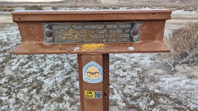
H.R.R 9 - West Branch of California Trail side of marker
RANKED BY RELEVANCE
1 ► Nevada, Pershing County, Lovelock — C-81 / HRR — California Trail - Granite Point / H.R.R-9 - West Branch of California Trail —  |
| On Derby Field Road. | |||
| 2 ► California, San Bernardino County, Victorville — California Route 66 Museum, Victorville, California — Route 66 Roadside Attraction — |
| On D Street (Business Interstate 15) east of 5th Street, on the right when traveling east. | |||
| 3 ► California, Alameda County, Fremont, Niles — California Nursery Historical Park — |
| Near Nursery Avenue near Niles Avenue. | |||
| 4 ► California, San Francisco City and County, San Francisco, Financial District — 3 — Bank of California — “The Grand Old Lady of California Street” — 400 California Street — |
| On California Street at Sansome Street, on the right when traveling west on California Street. | |||
| 5 ► Nebraska, Keith County, Brule — 313 — California Hill — |
| On U.S. 30 at M, on the right when traveling west on U.S. 30. | |||
| 6 ► California, Calaveras County, Cave City — 956 — California Caverns at Cave City — California Historical Landmark No. 956 — |
| On Cave City Rdoad 2 miles east of Michel Road, on the left when traveling east. | |||
| 7 ► California, Sacramento County, Sacramento, California State Capitol Park — California Native American Monument — |
| Near L Street west of 13th Street, on the left when traveling west. | |||
| 8 ► Nevada, Storey County, Virginia City — Bank of California — Historic Bank Site — 1864 – 1964 — |
| On South C Street (Nevada Route 341) at Taylor Street, on the right when traveling south on South C Street. | |||
| 9 ► California, Sacramento County, Sacramento, Central Business District — USS California Bell Memorial — |
| Near 10th Street. | |||
| 10 ► California, Monterey County, Monterey — Colton Hall – Site of California’s Original Constitution — |
| Near Pacific Street. | |||
| 11 ► California, Alameda County, Oakland, Downtown Oakland — 45 — Site of College of California — Original Campus of University of California — |
| On Franklin Street at 14th Street, on the right when traveling north on Franklin Street. | |||
| 12 ► California, Monterey County, Carmel-by-the-Sea — 135 — Junípero Serra / Establishing the California Missions / A Lasting Tribute — The Ave Maria Bell — |
| On Rio Road near Lausen Drive. | |||
| 13 ► Guatemala, Sacatepéquez, Antigua Guatemala — California Avocado Society Thanks Guatemala — Gracias a Guatemala de La Sociedad Aguacatera de California — |
| Near 4a Avenida Norte just south of 4a Avenida Norte and 4a Calle Poniente. | |||
| 14 ► California, Mariposa County, Mariposa — California State Mining and Mineral Museum — |
| Near Fairgrounds Road near California Highway 49, on the right when traveling east. | |||
| 15 ► California, Trinity County, Trinity Center — California – Oregon Trail — California – Oregon Road — |
| On Scott Mountain Road (Route 3 at milepost 83.3), on the right when traveling north. | |||
| 16 ► California, Alameda County, Berkeley, University of California Berkeley — 946 — University of California Berkeley Campus — |
| Near South Hall Road north of Campanile Way, on the right when traveling south. | |||
| 17 ► California, San Francisco City and County, San Francisco, Golden Gate Park — The California Midwinter International Exposition — |
| Near Music Concourse Drive north of Martin Luther King Jr. Drive, on the left. | |||
| 18 ► Virginia, Loudoun County, Leesburg — 1st California Regiment — |
| Near Ball’s Bluff Road, on the right when traveling east. | |||
| 19 ► California, Alameda County, Oakland, East Peralta — California Cotton Mill — Built in 1883 — Fruitvale History Tour Site — |
| On Calcot Place, on the left when traveling north. | |||
| 20 ► California, Sacramento County, Sacramento, Central Business District — 872 — California’s Historic Capitol — |
| On 10th Street at Capitol Mall, on the right when traveling north on 10th Street. | |||
| 21 ► California, Shasta County, Anderson — Northern California Veterans Memorials — Northern California Veterans Cemetery — |
| Near Gas Point Road. | |||
| 22 ► Idaho, Caribou County, Grace — California dreaming in 1841 — |
| On State Highway 34 near U.S. 30, on the right when traveling south. | |||
| 23 ► California, Sacramento County, Sacramento, New Era Park — 967 — California Almond Growers Exchange — Almond Processing Facility — |
| Near C Street. | |||
| 24 ► California, Los Angeles County, Los Angeles, South Los Angeles — California African American Museum — |
| On Figueroa Street at State Drive, on the right when traveling south on Figueroa Street. | |||
| 25 ► California, Santa Cruz County, Santa Cruz — California Pioneers — James Williams - Mary Patterson Williams — |
| Near Evergreen Street, on the right when traveling south. | |||
| 26 ► California, Monterey County, Monterey — The Great Seal of the State of California — |
| On Pacific Street near Jefferson Street. | |||
| 27 ► California, Alameda County, Fremont, Niles — California Nursery Historical Park Master Plan — |
| Near Nursery Avenue near Niles Avenue. | |||
| 28 ► California, Sacramento County, Sacramento, Central Business District — California Veterans Memorial — |
| On N St, on the right when traveling west. | |||
| 29 ► California, Imperial County, Seeley — Rock Art — California and Baja California Rock Art — |
| Near Kumeyaay Highway (Interstate 8) 3 miles west of Forester Road (County Road S30), on the right when traveling east. | |||
| 30 ► California, Orange County, Costa Mesa, South Coast Metro — California Scenario — Introduced in 1980 — |
| Near Anton Boulevard, on the right when traveling east. | |||
| 31 ► California, Alameda County, Emeryville — California & Nevada Railroad — 1884 – 1903 — |
| Near Horton Street near 59th Street, on the left when traveling north. | |||
| 32 ► California, Sacramento County, Sacramento, Central Business District — California Firefighters Memorial — |
| Near L Street. | |||
| 33 ► California, El Dorado County, Coloma — Changing California — |
| Near Coloma Road (California Route 49) north of Mt Murphy Road. | |||
| 34 ► California, El Dorado County, Pilot Hill — 551 — California’s First Grange Hall — |
| On State Highway 49, on the left when traveling north. | |||
| 35 ► California, Los Angeles County, Los Angeles, Downtown Los Angeles — First Gas Service in Southern California — |
| On Olvera Street at Paseo de la Plaza, on the right when traveling north on Olvera Street. | |||
| 36 ► California, Los Angeles County, Los Angeles, Northridge — Botanic Garden — California State University Northridge — |
| On Lindley Avenue 0.2 miles north of Nordhoff Street, on the right when traveling north. | |||
| 37 ► California, Los Angeles County, Lancaster — California Poppy Reserve — The Dream of a Poppy Park — |
| Near Lancaster Road at 150th Street West, on the right when traveling west. | |||
| 38 ► Oklahoma, Dewey County, Leedey — California Road — First Crossed Here 1849 — |
| On State Highway 34 - 0.5 miles north of Road N2050, on the right when traveling south. | |||
| 39 ► California, Napa County, Calistoga — Old Faithful Geyser of California — |
| Near Tubbs Lane east of Foothill Boulevard ( Route 128), on the left when traveling east. | |||
| 40 ► California, San Francisco City and County, San Francisco, Chinatown — 587 — Site of the First Public School in California — |
| Near Clay Street at Walter U Lum Place. | |||
| 41 ► California, Los Angeles County, Los Angeles, South Los Angeles — Creating Southern California — University of Southern California — USC — |
| Near Watt Way south of Downey Way. | |||
| 42 ► California, Plumas County, Portola — Central California Traction Company 24 — Steel Cupola Caboose — |
| Near Western Pacific Way 0.2 miles west of Main Street. | |||
| 43 ► California, Sonoma County, Sonoma — California Wine Heroes — |
| Near Old Winery Road east of Lovall Valley Road, on the right when traveling east. | |||
| 44 ► Kansas, Johnson County, Shawnee — Westport - Santa Fe Trail - Oregon/California Trail — |
| On Shawnee Mission Parkway near Melrose Lane, on the right when traveling east. | |||
| 45 ► Texas, Cooke County, Gainesville — The Old California Trail — 1849 - 1931 — |
| On West California Street (State Highway 51) at South Dixon Street, on the right when traveling east on West California Street. | |||
| 46 ► California, San Francisco City and County, San Francisco, Golden Gate Park — The California Academy of Sciences — |
| On Hagiwara Tea Garden Drive at Bowl Drive, on the left when traveling west on Hagiwara Tea Garden Drive. | |||
| 47 ► California, Contra Costa County, El Sobrante — California and Nevada Railroad — |
| Near San Pablo Dam Road. | |||
| 48 ► California, El Dorado County, Coloma — California Stamp Mill — |
| Near Coloma Road (California Route 49) north of Mt Murphy Road. | |||
| 49 ► California, Imperial County, Felicity — The Island of California — Felicity -- The Center of The World — |
| Near Center of The World Plaza 0.1 miles north of Frontage Road, on the left when traveling north. | |||
| 50 ► California, San Francisco City and County, San Francisco, Mission Dolores — California Volunteers' Memorial — |
| On Dolores Street near Market Street, in the median. | |||
| 51 ► Kansas, Doniphan County, Highland — The Oregon-California Trail — |
| Near Elgin Road. | |||
| 52 ► Kansas, Johnson County, Shawnee — California Road — |
| On Shawnee Mission Parkway near Melrose Lane, on the right when traveling east. | |||
| 53 ► Nevada, Elko County, Elko — The California Emigrant Trail Interpretive Center — |
| Near Interstate 80 at milepost 292, on the right when traveling west. | |||
| 54 ► California, Sacramento County, Sacramento, Midtown — 991 — California State Indian Museum — |
| On K Street. | |||
| 55 ► California, San Francisco City and County, San Francisco, Civic Center — Pioneer Monument / California Native Americans — Sculptor, Frank Happersberger / — |
| On Fulton Street east of Larkin Street, in the median. | |||
| 56 ► California, Sacramento County, Sacramento, Central Business District — California State Capitol Park — |
| Near L Street south of 12th Street, on the left when traveling west. | |||
| 57 ► California, San Diego County, San Diego, Balboa Park — California Quadrangle — |
| On El Prado, on the right when traveling west. | |||
| 58 ► California, Solano County, Benicia — 175 — Site of the First Protestant Church in California — |
| On West K Street, on the right when traveling west. | |||
| 59 ► California, Napa County, Yountville — Flags over California in 1870 — |
| Near Washington Street near Yount Street, on the left when traveling north. | |||
| 60 ► California, Sacramento County, Sacramento, Central Business District — The California Peace Officers Memorial — In Tribute — |
| Near 10th Street. | |||
| 61 ► Kansas, Douglas County, Lawrence — California and Oregon Trails Memorial — |
| On Crescent Road at West Campus Road, on the right when traveling east on Crescent Road. | |||
| 62 ► California, Los Angeles County, Los Angeles, South Los Angeles — California Science Center — |
| On Figueroa Street at State Drive, on the right when traveling south on Figueroa Street. | |||
| 63 ► California, San Diego County, San Diego, La Jolla — Conserving California's Coastal Treasures — Marine Protected Areas Safeguard Our Ocean's Bounty — |
| On Black's Beach Way. | |||
| 64 ► Pennsylvania, Washington County, California — California University of Pennsylvania — |
| On 3rd Street east of University Avenue, on the right when traveling east. | |||
| 65 ► California, San Francisco City and County, San Francisco, Chinatown — 85 — California Star — Office of the California Star Newspaper — |
| Near Washington Street near Grant Avenue, on the right when traveling east. | |||
| 66 ► Oklahoma, McClain County, Wayne — California Trail — Crossed here — |
| On State Highway 59 at U.S. 77, on the right when traveling west on State Highway 59. | |||
| 67 ► California, Sacramento County, Sacramento, Central Business District — California State Capitol Park — |
| Near 10th Street. | |||
| 68 ► California, Solano County, Benicia — 174 — First Masonic Hall Built in California — |
| On West J Street, on the right when traveling east. | |||
| 69 ► California, Monterey County, Monterey — First Newspaper in California — |
| Near Munras Avenue. | |||
| 70 ► California, Sacramento County, Sacramento, Central Business District — California State Capitol — |
| On 10th Street. | |||
| 71 ► California, Sonoma County, Jenner — California's First Windmill — |
| Near Coast Highway (State Highway 1) near Fort Ross Road, on the left when traveling north. | |||
| 72 ► Colorado, Garfield County, No Name — The California Zephyr — |
| Near Interstate 70 Frontage Road at milepost 119 east of No Name Lane (County Road 129). | |||
| 73 ► California, San Francisco City and County, San Francisco, Financial District — California Admission Day — Sept IX MDCCCL — |
| On Market Street at Montgomery Street on Market Street. | |||
| 74 ► California, Butte County, Oroville — 1043 — Northern California's Oldest Citrus Tree — Sweet Mother Orange and Her Seeds — |
| On Glenn Drive south of Meadowview Drive. | |||
| 75 ► California, Napa County, Yountville — Veterans Home of California — |
| On California Drive, on the left when traveling north. | |||
| 76 ► California, Orange County, Fullerton — 14 — California Hotel — |
| On Harbor Boulevard near Commonwealth Avenue, on the right when traveling south. | |||
| 77 ► California, Orange County, Yorba Linda — Richard Nixon — A California Native Son — |
| Near Yorba Linda Boulevard at Eureka Avenue. | |||
| 78 ► California, San Francisco City and County, San Francisco, Golden Gate Park — California Midwinter International Exposition — |
| On Hagiwara Tea Garden Drive south of Bowl Drive, on the left when traveling south. | |||
| 79 ► Missouri, Buchanan County, St. Joseph, Washington Township — The California - Oregon Trail — 1840s & 1850s — |
| Near Felix Street. | |||
| 80 ► Pennsylvania, Washington County, California — California — (Keystone Marker) — |
| On 3rd Street (Pennsylvania Route 88) at Mechanic Street, on the right when traveling east on 3rd Street. | |||
| 81 ► California, Orange County, Dana Point — California's Highway 1 — Pacific Coast Highway — |
| On Pacific Coast Highway (California Route 1) west of Doheny Park, on the right when traveling west. | |||
| 82 ► Delaware, Kent County, Dover, East Dover Hundred — Sequoia - A California Redwood — |
| Near Kings Highway Southwest at Pennsylvania Avenue, on the right when traveling north. | |||
| 83 ► Kansas, Pottawatomie County, Westmoreland — 20 — The California - Oregon Trail — |
| On The Road to Oz Highway (State Highway 99), on the right when traveling south. | |||
| 84 ► Pennsylvania, Washington County, California — California University of Pennsylvania — |
| On 3rd Street just east of University Avenue, on the right when traveling east. | |||
| 85 ► California, Sacramento County, Elk Grove — 817 — Site of the First County Free Library Branch in California |
| Near Elk Grove Boulevard. Reported missing. | |||
| 86 ► California, San Francisco City and County, San Francisco, Chinatown — 86 — California Theatre — |
| On Bush Street, on the left when traveling east. | |||
| 87 ► California, Ventura County, Ventura — A Brief History of California State Parks — Preserving and Protecting our Heritage — San Buenaventura State Beach — |
| Near San Pedro Street at Pierpoint Boulevard. | |||
| 88 ► Wyoming, Natrona County, Casper — Oregon-California Trail — C.H. King and Company — |
| On South Center Street at East 1st Steet, on the right when traveling north on South Center Street. | |||
| 89 ► California, Contra Costa County, Concord — Concord, California - Kitakami, Japan — |
| Near Parkside Drive near Salvio Street. | |||
| 90 ► California, Monterey County, Monterey — 136 — First Theater in California — California Historical Landmark No. 136 — |
| On Pacific Street at Scott Street, on the left when traveling north on Pacific Street. | |||
| 91 ► California, Napa County, Yountville — 828 — Veterans Home of California — |
| On California Drive at Solano Avenue, on the left when traveling west on California Drive. | |||
| 92 ► California, Stanislaus County, Newman — West of This Point is the California Aqueduct — |
| Near West Side Highway (Interstate 5) 0.1 miles south of Shields Road, on the right when traveling south. | |||
| 93 ► California, Santa Clara County, Sunnyvale, Heritage District — Hendy Stamp Mill / Hendy's "California" Stamp Mill — |
| Near North Sunnyvale Avenue near East California Avenue. | |||
| 94 ► California, Alameda County, Berkeley — California Memorial Stadium — War Memorial — |
| Near Gridiron Way. | |||
| 95 ► California, Humboldt County, Trinidad — Spain Claims Northern California — |
| Near Lighthouse Road. | |||
| 96 ► California, Mono County, Benton — Montgomery City California — |
| On Highway 6, on the right when traveling north. | |||
| 97 ► California, Sacramento County, Sacramento, Southside Park — 526 — California’s First Passenger Railroad — |
| On R Street at 3rd Street, on the left when traveling west on R Street. | |||
| 98 ► California, San Bernardino County, San Bernardino — California Theater — Historic Site — |
| On West 4th Street 0.1 miles west of N E Street, on the right when traveling west. | |||
| 99 ► California, San Francisco City and County, San Francisco, Tenderloin — California Labor School — Uptown Tenderloin Lost Landmarks — 1947 - 1951 — |
| Near Golden Gate Avenue west of Leavenworth Street. | |||
| 100 ► California, Sonoma County, Sonoma — Pioneer of the California Wine World — 1812-1869 — |
| Near Old Winery Road east of Lovall Valley Road, on the right when traveling east. | |||
8928 entries matched your criteria. The first 100 are listed above. Next 100 ⊳
Thin black lines indicate changes in relevance. Between each pair of lines entries are ordered geographically but all have the same relevance.
* Inflectional forms of words are their plurals, singulars, and possessives as well as gramatical tenses and similar variations.
Nov. 11, 2026