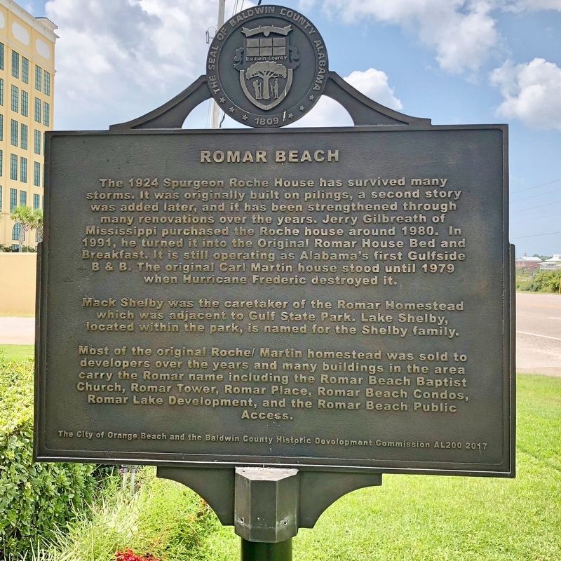
Romar Beach began as a large homestead property with three miles of beachfront spanning from Gulf State Park to Hwy 161 in Orange Beach. The original property now covers only 480 feet. It was a true homestead and the owners were required to ‘till . . . — — Map (db m122463) HM
"Alabama's First Farm Winery Since Prohibition"
A 50 acre Muscadine Grape Vineyard was established
at this site in 1972 to produce grapes for Bartels
Winery of Pensacola, Florida. In 1979, legislation
sponsored by Rep. John M. McMillan . . . — — Map (db m122470) HM
“Damn The Torpedoes!” is the familiar battle cry, but there’s much more to the story! The Mobile Bay Civil War Trail is your guide to military movements and the way of life on and around Mobile Bay in the closing two years of the Civil War. Stand . . . — — Map (db m81853) HM
In commemoration of all Sky Soldiers
whose valor and sacrifice in defense of
South Vietnam must never be forgotten
"All Gave Some – Some Gave All" — — Map (db m100946) WM
This earthen mound was part of a redoubt constructed by the 1st Division, U.S. Colored Troops in April, 1865. The regiment saw considerable action against Confederate warships protecting the Blakely River. These earthworks have been preserved as a . . . — — Map (db m100853) HM
Born in Winchester, Virginia, he moved to Missouri where at age 17 he enlisted in the State Guard. In 1861 he became a Private in the Confederate States Army, was captured during the Battle of Wilson's Creek and escaped.
Captain Danner . . . — — Map (db m100880) HM
The earliest outline of a recognizable bay on the northern coast of the Gulf of Mexico was shown on a 1507 map by German cartographer Martin Waldeseemuller–the same map to first apply the name "America" to the New World.
Alonso Álvarez de . . . — — Map (db m100841) HM
A trail used in early times by Indians, Spanish Explorers, French Settlers and later by soldiers during the battle of Spanish Fort 1865. At one time a stream driven train paralleled this trace. Its ancient road bed can still be seen south of this . . . — — Map (db m100877) HM
Named in honor of the 1,810 Men in Gray who defended the eastern approaches to Mobile in the battle of Spanish Fort March 26 ~ April 8-9, 1865. Here Brig. Gen. R. L. Gibson, C.S.A. engaged “…more than 20,000” enemy troops in the last . . . — — Map (db m100878) HM
Twenty-nine Union field guns, manned by men of the 3d Indiana,
1st Illinois and 2d Iowa Batteries, shelled these Confederate trenches
for 13 consecutive days and nights. The fact that these trenches were
never breached, attests to the courage of . . . — — Map (db m100873) HM
Confederate Redoubt No. 3
Capt. Cuthbert Slocomb of the 5th Company, Washington Artillery of New Orleans, commanded Redoubt No. 3, also known as Battery Blair,
consisted of one 8-inch Columbiad, two 12-pound Napoleons, one 3-inch ordinance . . . — — Map (db m168270) HM
Confederate Redoubt No. 4
Redoubt No. 4 was part of the Confederate line known as Red Fort. Capt. John Phillip’s Tennessee Light Artillery manned the redoubt until they were relieved on April 4, 1865 by Garrity's Alabama Light Artillery. Lt. . . . — — Map (db m120341) HM
Confederate Redoubt No. 5
Also called the Sandbag Battery, Redoubt No. 5 was originally commanded by Lt. Andrew Hargrove of Lumsden's Tuscaloosa Battery, Company F, 2nd Alabama Light Artillery Battalion. During the early stages of the . . . — — Map (db m168290) HM
From this Confederate Fort 15 heavy artillery guns, repelled elements of 2 Union Army Corps, routed 5 ironclad monitors attacking up the Blakely River and for 13 days helped prevent the capture of Mobile until after General Lee's Surrender at . . . — — Map (db m100911) HM
Highest point along 2 miles of Confederate battle lines extending east and north. Here 200 soldiers from Georgia, Louisiana & Arkansas, held off a numerically superior Union Force for thirteen days and nights in the last battle of the War Between . . . — — Map (db m100913) HM
Dedicated to the men of the Confederate States of America who valiantly fought for our American liberties, "Governments are instituted among men, deriving their just powers from the consent of the governed... whenever any form of government becomes . . . — — Map (db m100936) HM
Courts met under "Jury Oak" early 1800s. Judge presided while sitting on tree limb. Public executions held at nearby "hanging tree". — — Map (db m221963) HM
Built of red clay, armed with 12 heavy guns and served by 307 crack
Confederate Artilleryman from Batteries Perry (Tenn.) Phillips (Tenn.) Lumsden (Ala.) and Garrity (Mobile, Ala.). It was the keystone in the defense of Spanish Fort, 1865. — — Map (db m100868) HM
During the Revolutionary War, France, Spain, Britain, and the United States were interested in the fate of this region. In March 1780, Spanish forces captured Mobile. They established a palisaded fort with trenches (one mile north of here) to . . . — — Map (db m61451) HM
Saluda Hill Cemetery is a private historical cemetery established in 1824. Among the graves here is that of Zachariah Godbold, the only known Revolutionary War veteran buried in Baldwin County. Many Blakeley residents and Confederate soldiers also . . . — — Map (db m81854) HM
Manned with sailors and commanded by Lt. Commander Gillis of the U.S.S. Milwaukee, which was sunk by a Confederate torpedo in Blakeley River. Armed with two 4.2 in. Parrott rifled cannon firing projectiles weighing 30 lbs., these guns fired on . . . — — Map (db m266005) HM
Rendezvous for Indians, Spanish, French and English Explorers. In 1865, Three Confederate Brigades, outnumbered 10 to 1, engaged the Army of West Mississippi (Union Forces) in the last battle of the War Between the States. March 26~April 9, 1865. — — Map (db m100844) HM
Spanish Fort is the gateway to the second largest delta in the United States. The Mobile-Tensaw, River Delta is 30 miles long and 12 miles wide. It covers more than 200,000 acres of swamps, river bottomlands and marshes and is considered the best . . . — — Map (db m285174) HM
Late on March 26, C.S. General St. John Liddell withdrew into the relative safety of Fort Blakeley and Spanish Fort, Liddell, assisted by General Francis Cockrell, assumed personal responsibility for the defense of Blakeley and put the defense of . . . — — Map (db m88990) HM
Canby brought up his heavy guns from Stark’s Landing a process that took several days, beginning on the 28th. Supported by the Federal monitors, Chickasaw and Winnebago, Canby tried to pound the enemy into submission The Confederates naturally . . . — — Map (db m88991) HM
On the evening of April 8th, 1865, while the Confederate fortifications were being shelled by Union artillery, the 8th Iowa Infantry advanced from near this point to the Confederate left and captured a part of the works, in hand to hand fighting. . . . — — Map (db m100883) HM
At dusk on April 8, 1865, 300 yards west of this site, the Union Army's 8th lowa Infantry and three Illinois Regiments breached the Confederate main line of resistance. Under the cover of night, troops holding the thin gray line spiked their guns . . . — — Map (db m100855) HM
Incorporated in 1814 by the legislature of the Mississippi Territory, prior to Alabama's statehood, the town of Blakeley was envisioned by the founder Josiah Blakeley as a premier trading canter and a rival to Mobile as a port owing to its deep . . . — — Map (db m280482) HM
The Union First Parallel
The main Union siege line during the Battle of Spanish Fort ran along this ridge. Brig. Gen. Eugene Carr's Division occupied the right flank of the Union line between here and Minette Bay. Carr's men initially . . . — — Map (db m100857) HM
Near this site was the location of the first of twenty-two artillery positions the Union army set up to bombard the Confederate fortifications of Spanish Fort. The Confederate forces were under the command of Brig Gen. Randall Gibson. Battery Tracy, . . . — — Map (db m120331) HM
Union Siege
Battery No. 21
Located on this bluff overlooking Minette Bay, Battery No. 21 anchored the right flank of Maj. Gen. Edward Canby's Army of West Mississippi during the Battle of Spanish Fort. Maj. Gen. Andrew Smith's XVI Army . . . — — Map (db m120339) HM
Dedicated to all women veterans
who have served, sacrificed
and suffered for our nation.
Your patriotism and courage are greatly
appreciated and will never be forgotten.
[Seals of the U.S. Army, Air Force, Navy, Marine Corps & . . . — — Map (db m100943) WM
Don't weep for me
O' Land of the free
When it was my time to fall
'Twas for my country's call
'Twas for the land that I loved
That I gave my all
And for the land that I loved,
I did freely give
And in her freedom
And . . . — — Map (db m122607) WM
Korean War
The Forgotten War
Remembered
1950 - 1953
In honor of all who served
and in memory of those who died
Freedom is not free
More than 8000 MIA's still unaccounted for
Reverse
The . . . — — Map (db m122618) WM
In honor of all who served in Southeast Asia during the Vietnam war. “Welcome home"
This nation should never forget the more than 58,000 who paid the ultimate sacrifice in the service of our country or the ones who were left behind. . . . — — Map (db m122644) HM WM
World War II
December 1941 - September 1945
Dedicated to all who served at
home and abroad - military and civilian
Pacific Theater • European Theater
Asian Theater • African Theater
{Reverse}
. . . — — Map (db m122673) WM
World War I
1914 – 1918
Unites States Casualties
126,000 Killed - 234,000 Wounded
Reverse
World War I, also known as the Great War, the European War and in the United States, the war to end all wars, was a . . . — — Map (db m122615) WM
William Bartram, America’s first native born artist - naturalist, passed through Baldwin County during the Revolutionary era, making the first scientific notations of its flora, fauna and inhabitants. As the appointed botanist of Britain’s King . . . — — Map (db m81855) HM
27 July 1813 – Battle of Burnt Corn
30 August 1813 – Fort Mims Massacre
31 August 1813 – Kimbell – James Massacre
2 September 1813 – Attack at Fort Sinquefield
13 September 1813 – Wood's Bluff . . . — — Map (db m122631) HM WM
Front:
Historic Stockton
Modern Stockton is situated on a hill just above the original settlement, which was abandoned around 1840 because of Yellow Fever outbreaks. No verified source for the town name exists. Most likely it was . . . — — Map (db m66390) HM
Site of one of Alabama’s first sawmills. In 1811, Joshua Kennedy engaged Jesse Ember to build two water-powered sawmills, convertible to grist mills, for a total of $1400. The mills were operated by Kennedy through 1820; were burned twice, once by . . . — — Map (db m66379) HM
Here on the banks of the Tensaw River -- named for the Tensa Indian tribe whose principal village was located at this place -- Major Robert Farmar developed a plantation c. 1772. Farmar was one of the most prominent and controversial Alabamians of . . . — — Map (db m66380) HM
In 1799 the first public school in Alabama was built just north of this site at Boatyard Lake in the Tensaw Community. More than 90 small schools dotted Baldwin County in the early twentieth century. This one room school was built in 1920 by African . . . — — Map (db m122669) HM
Weight: 17,200 pounds
Bore: 13 inches
Maximum Range: 4,325 yards (almost 2.5 miles)
Cast in Ft. Pitt, PA in 1862
Largest piece of artillery used in the Civil War, It was used
for sea coast fortifications or on mortar boats for . . . — — Map (db m122473) HM
First known as Baldwin Presbyterian Church, members met in 1847, in Old Union Church near John Gallagher Springs. In 1903, the membership was moved to this site and the name was changed to Stockton Presbyterian Church. In 1956, the membership moved . . . — — Map (db m66387) HM
Surveyed in 1799 to mark the 31° North Latitude, this line charted the first southern boundary of the United States, separating the U.S. from Spanish Florida. The line was marked at one-mile intervals by earthen mounds approximately fifteen-feet . . . — — Map (db m81856) HM
The American Revolution gave the United States its independence but the War of 1812 gave it status among the nations and established permanent peace with Great Britain.
Alabama had a significant role during the War of 1812. The Creek Indian . . . — — Map (db m122670) HM
Sonora Community
The community of Sonora was named in 1901 by the wife of the first postmaster, G.L. Sharretts. Situated near Red Hill Ford on Baker Branch and the intersection of travel routes between Silverhill, Magnolia Springs, Marlow . . . — — Map (db m130878) HM
Summerdale
The Summerdale area was settled in the early 1850's by several families of Scotch and Irish descent. By 1900, the town had a church, a saw mill, a turpentine business, and a hotel. Many families of different nationalities moved . . . — — Map (db m188733) HM
Boatyard Landing and Aaron Burr Spring
For over 200 years Boatyard Landing has been used for transportation, commerce, and recreation. This historic landing was named “Boat Yard” during the 1790s when settlers-built boats here with lumber . . . — — Map (db m247480) HM
Here in Creek Indian War 1813-14 took place most brutal massacre in American history.
Indians took fort with heavy loss, then killed all but about 36 of some 550 in the fort.
Creeks had been armed by British at Pensacola in this phase . . . — — Map (db m86293) HM
Front:
In 1813, people on the United State’s southwestern frontier were fearful. The Redstick faction of the Creek Indian Nation opposed growing American influence in the area and had voted for war. However, Creeks living in the Tensaw . . . — — Map (db m116678) HM
Fort Mims was the
fortified home and
outbuildings of Samuel,
Mims. A stockade
enclosed about an acre of
land, a block house, and
sixteen buildings,
including the Mms family
home, barns, kitchen,
smokehouse, and spinning
and weaving . . . — — Map (db m247552) HM
Samuel Mims first
appeared in Spanish
records in 1786. In 1797,
he acquired a land grant
near Boatyard Lake.
Here he established a
plantation and operated
a ferry across the
Alabama River near his home.
The plantation
consisted of . . . — — Map (db m247556) HM
Montgomery Hill Landing
In the late 1800’s and into the early 20th Century, Montgomery Hill Landing was used by local plantations to send and receive goods from Mobile or points North. Huge paddlewheel boats would dock here for loading and . . . — — Map (db m247493) HM
Tensaw
The native Mississippians, Tohomes, Mobilians, and Creeks inhabited this area for centuries. Tensaw was named for the Taensa people who lived nearby during the 1720s. They farmed the bottomlands and hunted the dense forests. . . . — — Map (db m247482) HM
As the occupants of Fort Mims took their
mid-day meal on August 30, 1813, a force of
around 700 Redstick Creek warriors charged
toward the fort's open east gate (1). Major Daniel
Beasley, commander of the Mississippi Territorial
Volunteers . . . — — Map (db m247568) HM
A blockhouse was located
on the northwest corner of
the fort. Blockhouses were
often used on the
American frontier.
Blockhouses were
sometimes stand alone
buildings or they could also
be part of a larger
defensive structure like . . . — — Map (db m247532) HM
The Mims homestead
was made up of a main
house and several small
buildings. The kitchen
and smokehouse stood
near here.
These were important
buildings, necessary for.
the preservation and
preparation of food.
The smokehouse . . . — — Map (db m247560) HM
On the north side of the
stockade, a projection
called the "bastion" was
adjacent to a building
known as the loom house
- a building housing
looms for weaving cloth.
Here the local Tensaw
militia, led by Captain
Dixon Bailey, held . . . — — Map (db m247544) HM
The Old Federal Road
The Old Federal Road ran parallel to this present road and on the same course in many areas for centuries this was a walking path used by native Americans. In 1805, the U. S. Government negotiated with the Creek Indians to . . . — — Map (db m247489) HM
During the night of August 29, 1813 Red Stick Creek warriors scouted around the fort. They noticed gun ports, holes in the log wall to fire a gun through, had been placed low on the wall.
During the August 30 attack, the Red Stick Creeks . . . — — Map (db m247527) HM
In 1813 the region known as the Tensaw was part
of Mississippi Territory. Until April, the town of
Mobile and adjacent lands south of 31° latitude
belonged to Spain's colony, West Florida. On April
8, American military units crossed the . . . — — Map (db m247562) HM
Inside the fortified
homestead were two
hand dug wells, which
supplied water for
drinking, cooking, and
bathing.
These wells were
excavated in 1964 under
the direction of the
Alabama Department of
Conservation.
One well was almost . . . — — Map (db m247538) HM
The house was designed and constructed by
Donald Kirk in 1914 for his parents Charles
Martin and Mary Harding Kirk. He studied civil
engineering at Auburn University and graduated
from Columbia University's School of Mines in
1910. The house is . . . — — Map (db m226707) HM
The Blessing of the Fleet is a tradition that began centuries ago in Mediterranean fishing communities. The practice is predominantly Catholic, though sometimes Episcopalian, and a blessing from the local priest is meant to ensure a safe and . . . — — Map (db m117257) HM
Founded in 1786 by Joseph Bouzage (Bosarge), Bayou La Batre was incorporated in 1955. The local seafood industry in this seafaring town serves as a centerpiece for the Discovery Channel's series, Big Shrimping. In addition, the city was . . . — — Map (db m117254) HM
Originally called "Reviere D'Erbane," the bayou acquired present name from French-maintained battery of artillery on West Bank for defense. First permanent settlement on south Mobile County mainland. Founded 1786 when Joseph Bouzage (Bosarge), . . . — — Map (db m117256) HM
The stream near the site, known as Bayou la Batre, was known during the period of French occupation as "Riviere d'Erbane," then as "Rivere la batterie" because of the French artillery battery located on its banks. The town's name consists of bayou, . . . — — Map (db m117255) HM
On December 23, 1784, the Spanish civil-military governor
of Mobile, Don Henri Grimarest, granted a 1,938-acre tract of
land to Dr. John Baptist Chastang for habitation and
cultivation. At that time Dr. Chastang was living at Fuerte San
Esteban . . . — — Map (db m149279) HM
The name Chickasaw originated from Native Americans living in the area prior to the arrival of the French settlement at Twenty-Seven Mile Bluff in 1702. Native Americans from the Apalachee and Choctaw Tribes referred to the creek running through . . . — — Map (db m111286) HM
On April 30, 1865, C.S. General Richard Taylor, by then back in Meridian, received a wire from U. S. General Edward Canby. The truce negotiated at Magee Farm, Canby informed him, must end in 48 hours, because Washington had rejected the . . . — — Map (db m126690) HM
Here on May 4, 1865 Lt. Gen. Richard Taylor, C.S.A. surrendered the last organized Confederate forces, the Department of Alabama, Mississippi and East Louisiana, to Major Gen. E.R.S. Canby, U.S.A. thereby bringing to an official close the War . . . — — Map (db m126730) HM
(English)
Site of
Old Mobile
Fort Louis de la Louisiane
Founded 1702 by
Pierre Le Moyne d’Iberville
Under orders of Louis XIV
First Capital of French Louisiana
1702-1711
(French)
Site de
Vieux Mobile
Fort . . . — — Map (db m70588) HM
The Confederates built Fort Powell on Tower Island, an oyster shell bank fifty feet north of Grant's Pass. The Pass provided an easy route from Mobile Bay to New Orleans through Mississippi Sound. C.S. Lieutenant Colonel James M. Williams, only . . . — — Map (db m87239) HM
Once Farragut was in the Bay, capture of Fort Gaines and Powell would prevent his isolation there. So at 4:00 pm, August 3, 1864, 1,500 soldiers commanded by U.S. General Edward Canby (but under the operational direction of General Gordon . . . — — Map (db m87219) HM
At 7:25 a.m., August 5, 1864, Admiral Farragut’s lead monitor Tecumseh steered into the torpedo field at the mouth of Mobile Bay. The admiral had ordered Commander Tunis Craven, the Tecumseh’s captain, to engage the ram . . . — — Map (db m87234) HM
The huge timbers you see are a ship's keel section, washed ashore in the fury of Hurricane Georges in the fall of 1998. A house was destroyed with it's impact. The remains formed the bottom ridge line of the ship and would have held the ribs of . . . — — Map (db m87217) HM
This anchor came from the U.S.S. Hartford, Admiral Farragut's flagship during the Civil War "Battle of Mobile Bay" in August of 1864. It was there that he uttered the now famous words, "Damn the Torpedoes—Full Speed Ahead!" — — Map (db m87244) HM
When British forces arrived at Mobile Bay to assault Fort Bowyer on Mobile Point, half of the British army under the command of Sir John Kean, who was recovering from wounds suffered during the defeat at New Orleans, was landed on Dauphin Island to . . . — — Map (db m122427) HM
Incorporated in 1988, Dauphin Island
is recognized as the "Sunset Capital
of Alabama." Having served as the
capital of the Louisiana Territory in
the early 1700's, this unique barrier
island has a rich history. Today
Dauphin Island is admired . . . — — Map (db m226724) HM
This island, rich in history and legend, was
known to Europeans by 1502. Pineda visited in
1519, Narvaes and deVaca in 1528, the fleet of
deSoto in 1540, and the deLuna colonists in 1559.
In 1699, d'Iberville and Bienville arrived under
orders . . . — — Map (db m226727) HM
This park and bird refuge dates from the Mississippian Period (AD 1100 to 1550). Native Americans, who roasted oysters and fished in adjacent Dauphin Island Bay, visited the shell mounds for centuries. From excavations carried out in 1990, . . . — — Map (db m122350) HM
The platform that you can see east of Dauphin Island is operated by one of many oil and gas companies operating in Alabama waters. These platforms are extracting natural gas (methane), a relatively clean-burning petroleum product. The platform . . . — — Map (db m122548) HM
Established in 1821 for defense of Mobile Bay and named in honor of General Edmund Pendleton Gaines, 1777-1849 who played an important part in early Alabama History and while Commandant of Fort Stoddard captured Aaron Burr near McIntosh in February . . . — — Map (db m39393) HM
John F. Porter, Jr. Goat Tree Reserve
John F. Porter, Ph.D. served as volunteer Executive Director of Dauphin Island Bird Sanctuaries, Inc. (incorporated as Friends of Dauphin Island Audubon Sanctuary) from its inception in 1992 until his . . . — — Map (db m151634) HM
This was not you everyday outhouse. It had ten seats that connected by way of a culvert to the Bay. The tide would come in and out once a day and "flush" the toilets. This was necessary being that over 400 men used these latrines daily. It was . . . — — Map (db m260079) HM
In memory of the men and women
who answered the call of duty
to our beloved country (USA)
Gave the ultimate sacrifice
Their lives
These patriots, lost to eternity
Will not be forgotten — — Map (db m226760) WM
To Wait and Watch
In late August 1864 the Federals controlled Mobile Bay but could not attack Mobile. Admiral Farragut could not reach the City even with his light draft vessels, because the channels in the upper Bay had been obstructed. . . . — — Map (db m87243) HM
The building on this site has been called many names and served many functions in its long life. Originally known as the "Methodist-Episcopalian Church" and later as the "Little Church in the Pines," the structure was located a few miles from here . . . — — Map (db m146901) HM
The Grand Bay Elementary School for Colored was located on land adjacent to this building. Peter Alba donated the parcel on which the school was constructed in 1919. Soon thereafter, Black residents of Grand Bay and the Board of School . . . — — Map (db m189763) HM
This 'Mark 8' 2,700 pound
armor piercing (AP) projectile
is fired from one of the nine
16-inch, 45 caliber Mark 45
"Big Guns" aboard Battleship
USS Alabama (BB 60). It travels
at a speed of 2,300 feet per
second or 1,568 miles per . . . — — Map (db m245676) HM
Marks 1st Southern Boundary of the United States and the Mississippi Territory created in 1798
-----900 feet East-----
Stone marked 31° North Latitude separating the U.S. & Spanish Florida.
This line of demarcation ran from the . . . — — Map (db m104073) HM
"Damn the Torpedoes!" is a familiar battle cry, but there's more to the story! The Mobile Civil War Trail is your guide to military movements and the way of life on and around Mobile Bay in the closing two years of the Civil War. . . . — — Map (db m87288) HM
Medal of Honor Citation
For distinguished gallantry and valor above and beyond the call of duty as Commanding Officer of U. S. submarine GROWLER (SS-215) during her fourth war patrol in the Southwest Pacific from 10 January to 7 . . . — — Map (db m74811) WM
411 entries matched your criteria. Entries 101 through 200 are listed above. ⊲ Previous 100 — Next 100 ⊳